25.1.19. Vector overlay
25.1.19.1. Clip
Clips a vector layer using the features of an additional polygon layer.
Only the parts of the features in the input layer that fall within the polygons of the overlay layer will be added to the resulting layer.
警告
Geometry modification only
This operation modifies only the features geometry. The attribute values of the features are not modified, although properties such as area or length of the features will be modified by the clipping operation. If such properties are stored as attributes, those attributes will have to be manually updated.
このアルゴリズムは、プロバイダで空間インデックスを使用し、ジオメトリが準備されたジオメトリを使用し、ジオメトリがマスクジオメトリに完全に含まれていない場合に切り抜き操作を適用します。
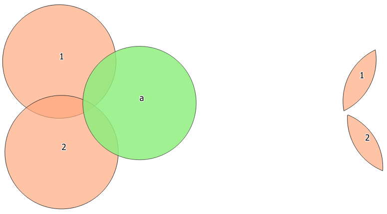
図 25.101 2つの地物入力レイヤと1つの地物オーバーレイレイヤの間のクリッピング操作(左)---明確にするために結果の地物は移動されています(右)
 Allows features in-place modification
of point, line, and polygon features
Allows features in-place modification
of point, line, and polygon features
Default menu:
パラメーター
ラベル |
名前 |
タイプ |
説明 |
|---|---|---|---|
Input layer |
|
[vector: any] |
Layer containing the features to be clipped |
Overlay layer |
|
[vector: polygon] |
Layer containing the clipping features |
Clipped |
|
[same as input] Default: |
Specify the layer to contain the features from the input layer that are inside the overlay (clipping) layer. One of:
The file encoding can also be changed here. |
出力
ラベル |
名前 |
タイプ |
説明 |
|---|---|---|---|
Clipped |
|
[same as input] |
Layer containing features from the input layer split by the overlay layer. |
Python code
Algorithm ID: qgis:clip
import processing
processing.run("algorithm_id", {parameter_dictionary})
The algorithm id is displayed when you hover over the algorithm in the Processing Toolbox. The parameter dictionary provides the parameter NAMEs and values. See プロセシングアルゴリズムをコンソールから使う for details on how to run processing algorithms from the Python console.
25.1.19.2. Difference
Extracts features from the input layer that don't fall within the boundaries of the overlay layer.
Input layer features that partially overlap the overlay layer feature(s) are split along the boundary of those feature(s) and only the portions outside the overlay layer features are retained.
警告
Geometry modification only
This operation modifies only the features geometry. The attribute values of the features are not modified, although properties such as area or length of the features will be modified by the clipping operation. If such properties are stored as attributes, those attributes will have to be manually updated.
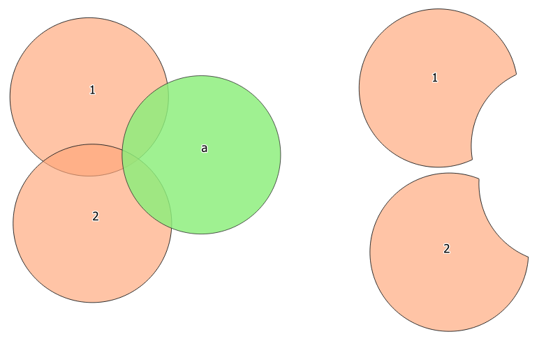
図 25.102 Difference operation between a two-features input layer and a single feature overlay layer (left) - resulting features are moved for clarity (right)
Allows features in-place modification
of point, line, and polygon features
Default menu:
パラメーター
ラベル |
名前 |
タイプ |
説明 |
|---|---|---|---|
Input layer |
|
[vector: any] |
Layer to extract (parts of) features from. |
Overlay layer |
|
[vector: any] |
Layer containing the geometries that will be subtracted from the input layer geometries. It is expected to have at least as many dimensions (point: 0D, line: 1D, polygon: 2D, volume: 3D) as the input layer geometries. |
Difference |
|
[same as input] Default: |
Specify the layer to contain the (parts of) features from the input layer that are not inside the overlay layer. One of:
The file encoding can also be changed here. |
出力
ラベル |
名前 |
タイプ |
説明 |
|---|---|---|---|
Difference |
|
[same as input] |
Layer containing (parts of) features from the input layer not overlapping the overlay layer. |
Python code
Algorithm ID: qgis:difference
import processing
processing.run("algorithm_id", {parameter_dictionary})
The algorithm id is displayed when you hover over the algorithm in the Processing Toolbox. The parameter dictionary provides the parameter NAMEs and values. See プロセシングアルゴリズムをコンソールから使う for details on how to run processing algorithms from the Python console.
25.1.19.3. Extract/clip by extent
Creates a new vector layer that only contains features which fall within a specified extent.
Any features which intersect the extent will be included.
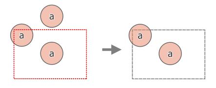
図 25.103 Extract operation between a three-feature input layer 'a' and a dashed extent (left) - resulting features with dashed extent for reference (right)
参考
パラメーター
ラベル |
名前 |
タイプ |
説明 |
|---|---|---|---|
Input layer |
|
[vector: any] |
Layer to extract (parts of) features from. |
Extent (xmin, xmax, ymin, ymax) |
|
[extent] |
Extent for clipping. Available methods are:
|
Clip features to extent |
|
[boolean] Default: False |
チェックを付けると、出力ジオメトリは自動的にマルチジオメトリに変換され、出力タイプが均一になります。さらに、それらのジオメトリは、ジオメトリ全体を出力として使用するのではなく、選択した範囲で切り取られます。 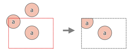
図 25.104 Extract operation between a three-feature input layer 'a' and a dashed extent (left) - resulting features with dashed extent for reference (right) |
Extracted |
|
[same as input] Default: |
Specify the layer to contain the features from the input layer that are inside the clip extent. One of:
The file encoding can also be changed here. |
出力
ラベル |
名前 |
タイプ |
説明 |
|---|---|---|---|
Extracted |
|
[same as input] |
Layer containing the clipped features. |
Python code
Algorithm ID: qgis:extractbyextent
import processing
processing.run("algorithm_id", {parameter_dictionary})
The algorithm id is displayed when you hover over the algorithm in the Processing Toolbox. The parameter dictionary provides the parameter NAMEs and values. See プロセシングアルゴリズムをコンソールから使う for details on how to run processing algorithms from the Python console.
25.1.19.4. Intersection
Extracts the portions of features from the input layer that overlap features in the overlay layer.
Features in the intersection layer are assigned the attributes of the overlapping features from both the input and overlay layers.
警告
Geometry modification only
This operation modifies only the features geometry. The attribute values of the features are not modified, although properties such as area or length of the features will be modified by the clipping operation. If such properties are stored as attributes, those attributes will have to be manually updated.
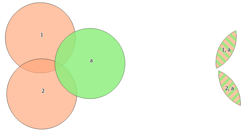
図 25.105 The intersection operation: A two-features input layer and a single feature overlay layer (left) - resulting features are moved for clarity (right)
Default menu:
参考
パラメーター
ラベル |
名前 |
タイプ |
説明 |
|---|---|---|---|
Input layer |
|
[vector: any] |
Layer to extract (parts of) features from. |
Overlay layer |
|
[vector: any] |
Layer containing the features to check for overlap. Its features' geometry is expected to have at least as many dimensions (point: 0D, line: 1D, polygon: 2D, volume: 3D) as the input layer's. |
Input fields to keep (leave empty to keep all fields) Optional |
|
[tablefield: any] [list] Default: None |
Field(s) of the input layer to keep in the output. If no fields are chosen all fields are taken. |
Overlay fields to keep (leave empty to keep all fields) Optional |
|
[tablefield: any] [list] Default: None |
Field(s) of the overlay layer to keep in the output. If no fields are chosen all fields are taken. |
Overlay fields prefix Optional |
|
[string] |
Prefix to add to the field names of the intersect layer's fields to avoid name collisions with fields in the input layer. |
Intersection |
|
[same as input] Default: |
Specify the layer to contain (the parts of) the features from the input layer that overlap one or more features from the overlay layer. One of:
The file encoding can also be changed here. |
出力
ラベル |
名前 |
タイプ |
説明 |
|---|---|---|---|
Intersection |
|
[same as input] |
Layer containing (parts of) features from the input layer that overlap the overlay layer. |
Python code
Algorithm ID: qgis:intersection
import processing
processing.run("algorithm_id", {parameter_dictionary})
The algorithm id is displayed when you hover over the algorithm in the Processing Toolbox. The parameter dictionary provides the parameter NAMEs and values. See プロセシングアルゴリズムをコンソールから使う for details on how to run processing algorithms from the Python console.
25.1.19.5. Line intersections
Creates point features where the lines from the two layers intersect.
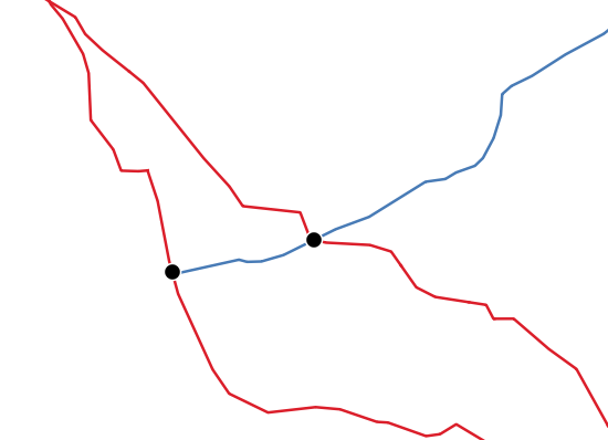
図 25.106 Points of intersection
Default menu:
パラメーター
Basic parameters
ラベル |
名前 |
タイプ |
説明 |
|---|---|---|---|
Input layer |
|
[vector: line] |
Input line layer. |
Intersect layer |
|
[vector: line] |
Layer to use to find line intersections. |
Input fields to keep (leave empty to keep all fields) Optional |
|
[tablefield: any] [list] Default: None |
Field(s) of the input layer to keep in the output. If no fields are chosen all fields are taken. |
Intersect fields to keep (leave empty to keep all fields) Optional |
|
[tablefield: any] [list] Default: None |
Field(s) of the intersect layer to keep in the output. If no fields are chosen all fields are taken. |
Intersection |
|
[vector: point] Default: |
Specify the layer to contain the intersection points of the lines from the input and overlay layers. One of:
The file encoding can also be changed here. |
Advanced parameters
ラベル |
名前 |
タイプ |
説明 |
|---|---|---|---|
Intersect fields prefix Optional |
|
[string] |
Prefix to add to the field names of the intersect layer's fields to avoid name collisions with fields in the input layer. |
出力
ラベル |
名前 |
タイプ |
説明 |
|---|---|---|---|
Intersections |
|
[vector: point] |
Point vector layer with the intersections. |
Python code
Algorithm ID: qgis:lineintersections
import processing
processing.run("algorithm_id", {parameter_dictionary})
The algorithm id is displayed when you hover over the algorithm in the Processing Toolbox. The parameter dictionary provides the parameter NAMEs and values. See プロセシングアルゴリズムをコンソールから使う for details on how to run processing algorithms from the Python console.
25.1.19.6. Split with lines
ラインまたはポリゴンを、別のレイヤのラインを使って切断します。両方のレイヤのジオメトリの交点が分割点とみなされます。
Output will contain multi geometries for split features.
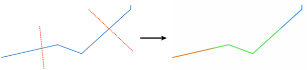
図 25.107 Split lines
Allows features in-place modification
of line and polygon features
パラメーター
ラベル |
名前 |
タイプ |
説明 |
|---|---|---|---|
Input layer |
|
[vector: line, polygon] |
Layer containing the lines or polygons to split. |
Split layer |
|
[vector: line] |
Line layer whose lines are used to define the breaking points. |
Split |
|
[same as input] Default: |
Specify the layer to contain the splitted (in case they are intersected by a line in the split layer) line/polygon features from the input layer. One of:
The file encoding can also be changed here. |
出力
ラベル |
名前 |
タイプ |
説明 |
|---|---|---|---|
Split |
|
[same as input] |
Output vector layer with split lines or polygons from input layer. |
Python code
Algorithm ID: qgis:splitwithlines
import processing
processing.run("algorithm_id", {parameter_dictionary})
The algorithm id is displayed when you hover over the algorithm in the Processing Toolbox. The parameter dictionary provides the parameter NAMEs and values. See プロセシングアルゴリズムをコンソールから使う for details on how to run processing algorithms from the Python console.
25.1.19.7. 対称差
入力レイヤとオーバーレイレイヤの両方からの地物を含むが、2つのレイヤ間の重なっている領域は削除されているレイヤを作成します。
対称差分レイヤの属性テーブルには、入力レイヤとオーバーレイレイヤの両方の属性とフィールドが含まれています。
警告
Geometry modification only
This operation modifies only the features geometry. The attribute values of the features are not modified, although properties such as area or length of the features will be modified by the clipping operation. If such properties are stored as attributes, those attributes will have to be manually updated.
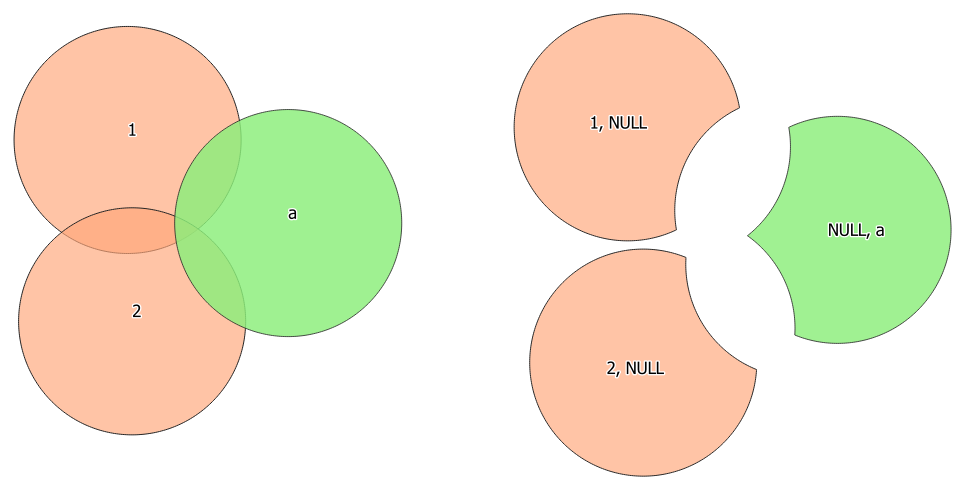
図 25.108 2つの地物入力レイヤと1つの地物オーバーレイレイヤの間の対称差操作(左)---明確にするために結果の地物は移動されています(右)
Default menu:
参考
パラメーター
Basic parameters
ラベル |
名前 |
タイプ |
説明 |
|---|---|---|---|
Input layer |
|
[vector: any] |
First layer to extract (parts of) features from. |
Overlay layer |
|
[vector: any] |
Second layer to extract (parts of) features from. Ideally the geometry type should be the same as input layer. |
Symmetrical difference |
|
[same as input] Default: |
Specify the layer to contain (the parts of) the features from the input and overlay layers that do not overlap features from the other layer. One of:
The file encoding can also be changed here. |
Advanced parameters
ラベル |
名前 |
タイプ |
説明 |
|---|---|---|---|
Overlay fields prefix Optional |
|
[string] |
Prefix to add to the field names of the overlay layer's fields to avoid name collisions with fields in the input layer. |
出力
ラベル |
名前 |
タイプ |
説明 |
|---|---|---|---|
Symmetrical difference |
|
[same as input] |
Layer containing (parts of) features from each layer not overlapping the other layer. |
Python code
Algorithm ID: qgis:symmetricaldifference
import processing
processing.run("algorithm_id", {parameter_dictionary})
The algorithm id is displayed when you hover over the algorithm in the Processing Toolbox. The parameter dictionary provides the parameter NAMEs and values. See プロセシングアルゴリズムをコンソールから使う for details on how to run processing algorithms from the Python console.
25.1.19.8. Union
入力レイヤの地物が互いに重なっていないかどうかをチェックし、重なった部分と重なっていない部分を別の地物に分解します。重なった部分は、重なった地物の数だけ同じ地物が作成されます。
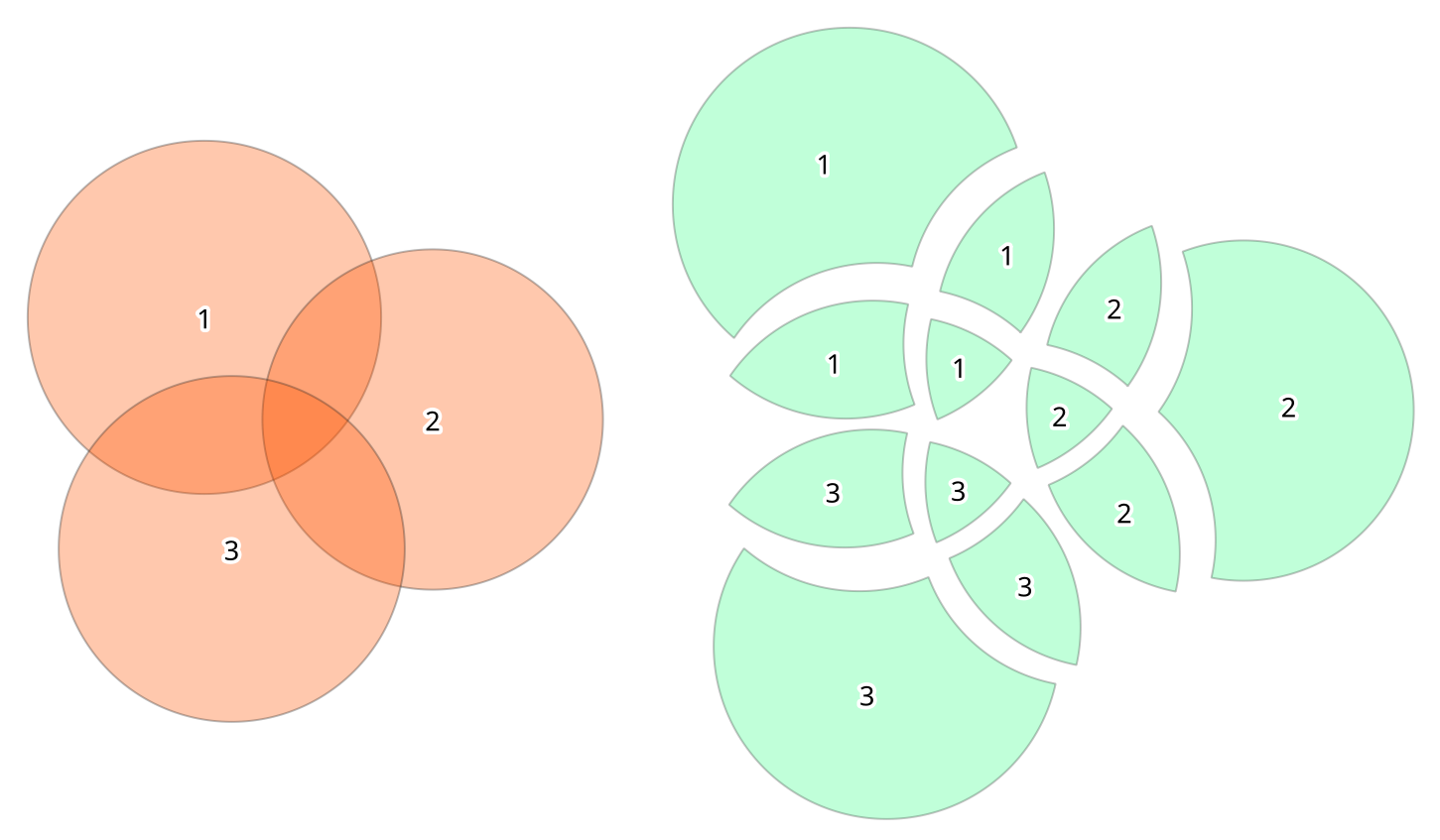
図 25.109 Union operation with a single input layer of three overlapping features (left) - resulting features are moved for clarity (right)
オーバーレイレイヤも使用できます。その場合、それぞれのレイヤの地物はもう一方のレイヤの地物と重なり合う部分で分割され、入力レイヤとオーバーレイレイヤの両方からのすべての部分を含むレイヤーが作成されます。和集合(ユニオン)レイヤの属性テーブルは、重ならない地物についてはそれぞれの元のレイヤからの属性値、重なり合う地物については両方のレイヤからの属性値が収納されます。
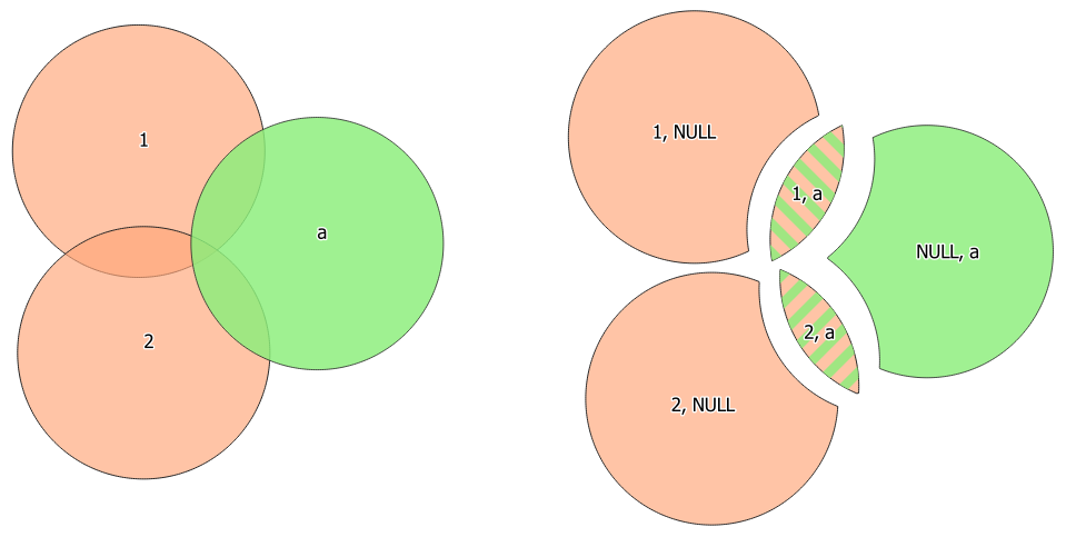
図 25.110 2つの地物入力レイヤと1つの地物オーバーレイレイヤの間の和操作(左)---明確にするために結果の地物は移動されています(右)
注釈
union(A,B) アルゴリズムの場合、レイヤAのジオメトリ同士またはレイヤBのジオメトリ同士の中で重なりがある場合、これらは溶解されません:すべての重なりを溶解するためには union(union(A,B)) をする必要があります。つまり作成された結果 X=union(A,B) に対して単一レイヤの union(X) を実行します。
Default menu:
参考
パラメーター
Basic parameters
ラベル |
名前 |
タイプ |
説明 |
|---|---|---|---|
Input layer |
|
[vector: any] |
Input vector layer to split at any intersections. |
Overlay layer Optional |
|
[vector: any] |
Layer that will be combined to the first one. Ideally the geometry type should be the same as input layer. |
Union |
|
[same as input] Default: |
Specify the layer to contain the (split and duplicated) features from the input layer and the overlay layer. One of:
The file encoding can also be changed here. |
Advanced parameters
ラベル |
名前 |
タイプ |
説明 |
|---|---|---|---|
Overlay fields prefix Optional |
|
[string] |
Prefix to add to the field names of the overlay layer's fields to avoid name collisions with fields in the input layer. |
出力
ラベル |
名前 |
タイプ |
説明 |
|---|---|---|---|
Union |
|
[same as input] |
Layer containing all the overlapping and non-overlapping parts from the processed layer(s). |
Python code
Algorithm ID: qgis:union
import processing
processing.run("algorithm_id", {parameter_dictionary})
The algorithm id is displayed when you hover over the algorithm in the Processing Toolbox. The parameter dictionary provides the parameter NAMEs and values. See プロセシングアルゴリズムをコンソールから使う for details on how to run processing algorithms from the Python console.