25.1.19. Vector overlay
25.1.19.1. Clip
Clips a vector layer using the features of an additional polygon layer.
Only the parts of the features in the input layer that fall within the polygons of the overlay layer will be added to the resulting layer.
Aviso
Apenas modificação de geometria
Esta operação modifica apenas a geometria das feições. Os valores dos atributos das características são não modificados, embora propriedades tais como área ou comprimento das características sejam modificadas pela operação de recorte. Se tais propriedades forem armazenadas como atributos, esses atributos terão que ser atualizados manualmente.
This algorithm uses spatial indexes on the providers, prepared geometries and apply a clipping operation if the geometry isn’t wholly contained by the mask geometry.
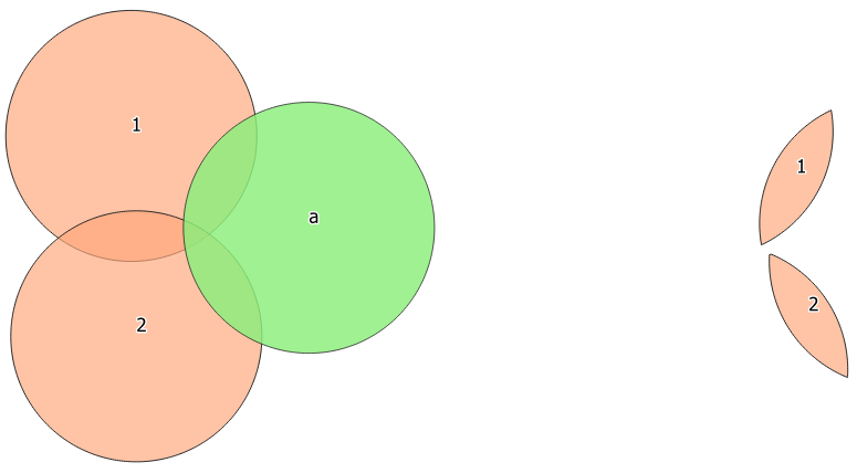
Fig. 25.101 Clipping operation between a two-features input layer and a single feature overlay layer (left) - resulting features are moved for clarity (right)
 Allows features in-place modification
of point, line, and polygon features
Allows features in-place modification
of point, line, and polygon features
Default menu:
Ver também
Parâmetros
Etiqueta |
Nome |
Tipo |
Descrição |
|---|---|---|---|
Camada de entrada |
|
[vetor: qualquer] |
Layer containing the features to be clipped |
Overlay layer |
|
[vetor: polígono] |
Layer containing the clipping features |
Clipped |
|
[same as input] Padrão: |
Specify the layer to contain the features from the input layer that are inside the overlay (clipping) layer. One of:
A codificação do arquivo também pode ser alterada aqui. |
Saídas
Etiqueta |
Nome |
Tipo |
Descrição |
|---|---|---|---|
Clipped |
|
[same as input] |
Layer containing features from the input layer split by the overlay layer. |
Código Python
Algorithm ID: qgis:clip
import processing
processing.run("algorithm_id", {parameter_dictionary})
The algorithm id is displayed when you hover over the algorithm in the Processing Toolbox. The parameter dictionary provides the parameter NAMEs and values. See Usando os algoritmos do processamento a partir do Terminal Python. for details on how to run processing algorithms from the Python console.
25.1.19.2. Diferença
Extracts features from the input layer that don’t fall within the boundaries of the overlay layer.
Input layer features that partially overlap the overlay layer feature(s) are split along the boundary of those feature(s) and only the portions outside the overlay layer features are retained.
Aviso
Apenas modificação de geometria
Esta operação modifica apenas a geometria das feições. Os valores dos atributos das características são não modificados, embora propriedades tais como área ou comprimento das características sejam modificadas pela operação de recorte. Se tais propriedades forem armazenadas como atributos, esses atributos terão que ser atualizados manualmente.
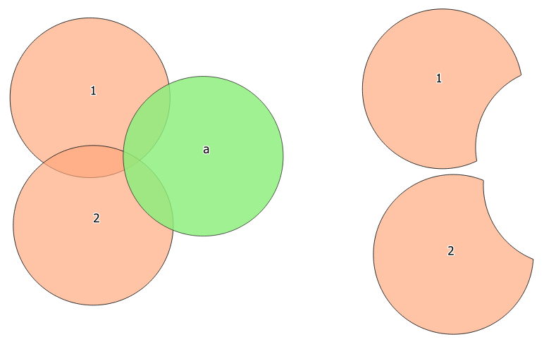
Fig. 25.102 Difference operation between a two-features input layer and a single feature overlay layer (left) - resulting features are moved for clarity (right)
Allows features in-place modification
of point, line, and polygon features
Default menu:
Ver também
Parâmetros
Etiqueta |
Nome |
Tipo |
Descrição |
|---|---|---|---|
Camada de entrada |
|
[vetor: qualquer] |
Layer to extract (parts of) features from. |
Overlay layer |
|
[vetor: qualquer] |
Layer containing the geometries that will be subtracted from the input layer geometries. It is expected to have at least as many dimensions (point: 0D, line: 1D, polygon: 2D, volume: 3D) as the input layer geometries. |
Diferença |
|
[same as input] Padrão: |
Especifique a camada para conter as (partes das) feições da camada de entrada que não estão dentro da camada de sobreposição. Um de:
A codificação do arquivo também pode ser alterada aqui. |
Saídas
Etiqueta |
Nome |
Tipo |
Descrição |
|---|---|---|---|
Diferença |
|
[same as input] |
Camada contendo (partes das) feições da camada de entrada que não se sobrepõe à camada de sobreposição. |
Código Python
Algorithm ID: qgis:difference
import processing
processing.run("algorithm_id", {parameter_dictionary})
The algorithm id is displayed when you hover over the algorithm in the Processing Toolbox. The parameter dictionary provides the parameter NAMEs and values. See Usando os algoritmos do processamento a partir do Terminal Python. for details on how to run processing algorithms from the Python console.
25.1.19.3. Extract/clip by extent
Cria uma nova camada vetorial que contém apenas feições que se enquadram em uma extensão especificada.
Quaisquer feições que cruzem a extensão serão incluídas.
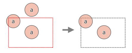
Fig. 25.103 Operação de extração entre uma camada de entrada de três características “a” e uma extensão tracejada (esquerda) - características resultantes com extensão tracejada para referência (direita)
Ver também
Parâmetros
Etiqueta |
Nome |
Tipo |
Descrição |
|---|---|---|---|
Camada de entrada |
|
[vetor: qualquer] |
Layer to extract (parts of) features from. |
Extensão (xmin, xmax, ymin, ymax) |
`` EXTENSÃO`` |
[extensão] |
Extent for clipping. Os métodos disponíveis são:
|
Clip features to extent |
|
[boleano] Padrão: Falso |
If checked, output geometries will be automatically converted to multi geometries to ensure uniform output types. Moreover the geometries will be clipped to the extent chosen instead of taking the whole geometry as output. 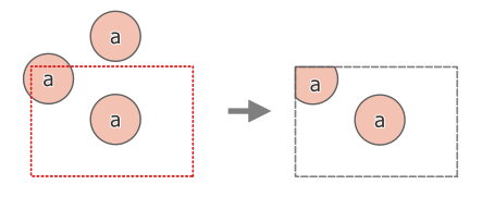
Fig. 25.104 Operação de extração entre uma camada de entrada de três características “a” e uma extensão tracejada (esquerda) - características resultantes com extensão tracejada para referência (direita) |
Extraído |
|
[same as input] Padrão: |
Specify the layer to contain the features from the input layer that are inside the clip extent. One of:
A codificação do arquivo também pode ser alterada aqui. |
Saídas
Etiqueta |
Nome |
Tipo |
Descrição |
|---|---|---|---|
Extraído |
|
[same as input] |
Layer containing the clipped features. |
Código Python
Algorithm ID: qgis:extractbyextent
import processing
processing.run("algorithm_id", {parameter_dictionary})
The algorithm id is displayed when you hover over the algorithm in the Processing Toolbox. The parameter dictionary provides the parameter NAMEs and values. See Usando os algoritmos do processamento a partir do Terminal Python. for details on how to run processing algorithms from the Python console.
25.1.19.4. Interseção
Extrai as partes das feições da camada de entrada que se sobrepõem aàs feições na camada de sobreposição.
As feições na camada de interseção são atribuídas aos atributos das feições sobrepostas das camadas de entrada e de sobreposição.
Aviso
Apenas modificação de geometria
Esta operação modifica apenas a geometria das feições. Os valores dos atributos das características são não modificados, embora propriedades tais como área ou comprimento das características sejam modificadas pela operação de recorte. Se tais propriedades forem armazenadas como atributos, esses atributos terão que ser atualizados manualmente.
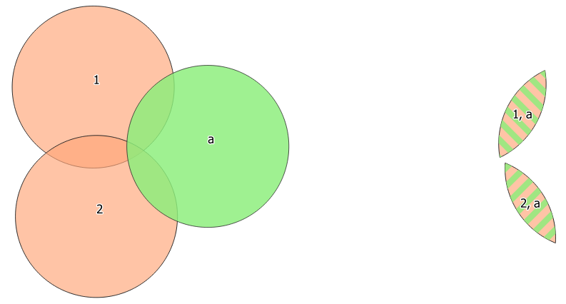
Fig. 25.105 The intersection operation: A two-features input layer and a single feature overlay layer (left) - resulting features are moved for clarity (right)
Default menu:
Parâmetros
Etiqueta |
Nome |
Tipo |
Descrição |
|---|---|---|---|
Camada de entrada |
|
[vetor: qualquer] |
Layer to extract (parts of) features from. |
Overlay layer |
|
[vetor: qualquer] |
Layer containing the features to check for overlap. Its features’ geometry is expected to have at least as many dimensions (point: 0D, line: 1D, polygon: 2D, volume: 3D) as the input layer’s. |
Input fields to keep (leave empty to keep all fields) Opcional |
|
[tablefield: any] [list] Padrão: Nenhum |
Field(s) of the input layer to keep in the output. If no fields are chosen all fields are taken. |
Overlay fields to keep (leave empty to keep all fields) Opcional |
|
[tablefield: any] [list] Padrão: Nenhum |
Field(s) of the overlay layer to keep in the output. If no fields are chosen all fields are taken. |
Overlay fields prefix Opcional |
|
[string] |
Prefix to add to the field names of the intersect layer’s fields to avoid name collisions with fields in the input layer. |
Intersecção |
|
[same as input] Padrão: |
Specify the layer to contain (the parts of) the features from the input layer that overlap one or more features from the overlay layer. One of:
A codificação do arquivo também pode ser alterada aqui. |
Saídas
Etiqueta |
Nome |
Tipo |
Descrição |
|---|---|---|---|
Intersecção |
|
[same as input] |
Layer containing (parts of) features from the input layer that overlap the overlay layer. |
Código Python
Algorithm ID: qgis:intersection
import processing
processing.run("algorithm_id", {parameter_dictionary})
The algorithm id is displayed when you hover over the algorithm in the Processing Toolbox. The parameter dictionary provides the parameter NAMEs and values. See Usando os algoritmos do processamento a partir do Terminal Python. for details on how to run processing algorithms from the Python console.
25.1.19.5. Interseções de linha
Cria feições de ponto onde as linhas das duas camadas se cruzam.
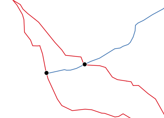
Fig. 25.106 Pontos de interseção
Default menu:
Parâmetros
Parâmetros básicos
Etiqueta |
Nome |
Tipo |
Descrição |
|---|---|---|---|
Camada de entrada |
|
[vetor: linha] |
Input line layer. |
camada de interseção* |
`` INTERSEÇÃO`` |
[vetor: linha] |
Layer to use to find line intersections. |
Input fields to keep (leave empty to keep all fields) Opcional |
|
[tablefield: any] [list] Padrão: Nenhum |
Field(s) of the input layer to keep in the output. If no fields are chosen all fields are taken. |
Intersect fields to keep (leave empty to keep all fields) Opcional |
|
[tablefield: any] [list] Padrão: Nenhum |
Field(s) of the intersect layer to keep in the output. If no fields are chosen all fields are taken. |
Intersecção |
|
[vetor: ponto] Padrão: |
Especifique a camada para conter os pontos de interseção das linhas das camadas de entrada e de sobreposição. Um de:
A codificação do arquivo também pode ser alterada aqui. |
Parâmetros avançados
Etiqueta |
Nome |
Tipo |
Descrição |
|---|---|---|---|
Intersect fields prefix Opcional |
|
[string] |
Prefix to add to the field names of the intersect layer’s fields to avoid name collisions with fields in the input layer. |
Saídas
Etiqueta |
Nome |
Tipo |
Descrição |
|---|---|---|---|
Interseções |
|
[vetor: ponto] |
Camada vetorial de ponto com as interseções. |
Código Python
Algorithm ID: qgis:lineintersections
import processing
processing.run("algorithm_id", {parameter_dictionary})
The algorithm id is displayed when you hover over the algorithm in the Processing Toolbox. The parameter dictionary provides the parameter NAMEs and values. See Usando os algoritmos do processamento a partir do Terminal Python. for details on how to run processing algorithms from the Python console.
25.1.19.6. Split with lines
Splits the lines or polygons in one layer using the lines in another layer to define the breaking points. Intersection between geometries in both layers are considered as split points.
Output will contain multi geometries for split features.
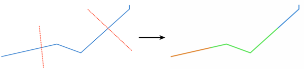
Fig. 25.107 Linhas divididas
Allows features in-place modification
of line and polygon features
Parâmetros
Etiqueta |
Nome |
Tipo |
Descrição |
|---|---|---|---|
Camada de entrada |
|
[vetor: linha, polígono] |
Camada que contém as linhas ou polígonos a serem divididos. |
Split layer |
|
[vetor: linha] |
Line layer whose lines are used to define the breaking points. |
Dividir |
|
[same as input] Padrão: |
Specify the layer to contain the splitted (in case they are intersected by a line in the split layer) line/polygon features from the input layer. One of:
A codificação do arquivo também pode ser alterada aqui. |
Saídas
Etiqueta |
Nome |
Tipo |
Descrição |
|---|---|---|---|
Dividir |
|
[same as input] |
Output vector layer with split lines or polygons from input layer. |
Código Python
Algorithm ID: qgis:splitwithlines
import processing
processing.run("algorithm_id", {parameter_dictionary})
The algorithm id is displayed when you hover over the algorithm in the Processing Toolbox. The parameter dictionary provides the parameter NAMEs and values. See Usando os algoritmos do processamento a partir do Terminal Python. for details on how to run processing algorithms from the Python console.
25.1.19.7. Diferença simétrica
Creates a layer containing features from both the input and overlay layers but with the overlapping areas between the two layers removed.
The attribute table of the symmetrical difference layer contains attributes and fields from both the input and overlay layers.
Aviso
Apenas modificação de geometria
Esta operação modifica apenas a geometria das feições. Os valores dos atributos das características são não modificados, embora propriedades tais como área ou comprimento das características sejam modificadas pela operação de recorte. Se tais propriedades forem armazenadas como atributos, esses atributos terão que ser atualizados manualmente.
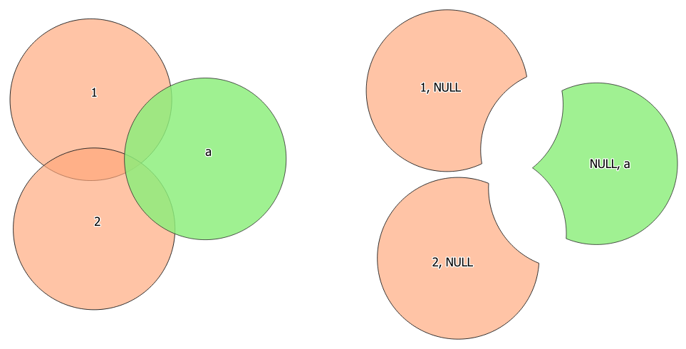
Fig. 25.108 Symmetrical difference operation between a two-features input layer and a single feature overlay layer (left) - resulting features are moved for clarity (right)
Default menu:
Ver também
Parâmetros
Parâmetros básicos
Etiqueta |
Nome |
Tipo |
Descrição |
|---|---|---|---|
Camada de entrada |
|
[vetor: qualquer] |
Primeira camada para extrair (partes de) feições de. |
Overlay layer |
|
[vetor: qualquer] |
Second layer to extract (parts of) features from. Ideally the geometry type should be the same as input layer. |
Diferença simétrica |
|
[same as input] Padrão: |
Specify the layer to contain (the parts of) the features from the input and overlay layers that do not overlap features from the other layer. One of:
A codificação do arquivo também pode ser alterada aqui. |
Parâmetros avançados
Etiqueta |
Nome |
Tipo |
Descrição |
|---|---|---|---|
Overlay fields prefix Opcional |
|
[string] |
Prefix to add to the field names of the overlay layer’s fields to avoid name collisions with fields in the input layer. |
Saídas
Etiqueta |
Nome |
Tipo |
Descrição |
|---|---|---|---|
Diferença simétrica |
|
[same as input] |
Layer containing (parts of) features from each layer not overlapping the other layer. |
Código Python
Algorithm ID: qgis:symmetricaldifference
import processing
processing.run("algorithm_id", {parameter_dictionary})
The algorithm id is displayed when you hover over the algorithm in the Processing Toolbox. The parameter dictionary provides the parameter NAMEs and values. See Usando os algoritmos do processamento a partir do Terminal Python. for details on how to run processing algorithms from the Python console.
25.1.19.8. União
Checks overlaps between features within the input layer and creates separate features for overlapping and non-overlapping parts. The area of overlap will create as many identical overlapping features as there are features that participate in that overlap.

Fig. 25.109 Union operation with a single input layer of three overlapping features (left) - resulting features are moved for clarity (right)
An overlay layer can also be used, in which case features from each layer are split at their overlap with features from the other one, creating a layer containing all the portions from both input and overlay layers. The attribute table of the union layer is filled with attribute values from the respective original layer for non-overlapping features, and attribute values from both layers for overlapping features.
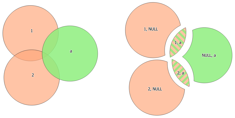
Fig. 25.110 Union operation between a two-features input layer and a single feature overlay layer (left) - resulting features are moved for clarity (right)
Nota
For union(A,B) algorithm, if there are overlaps among
geometries of layer A or among geometries of layer B, these are not
resolved: you need to do union(union(A,B)) to resolve all
overlaps, i.e. run single layer union(X) on the produced result
X=union(A,B).
Default menu:
Ver também
Parâmetros
Parâmetros básicos
Etiqueta |
Nome |
Tipo |
Descrição |
|---|---|---|---|
Camada de entrada |
|
[vetor: qualquer] |
Input vector layer to split at any intersections. |
Overlay layer Opcional |
|
[vetor: qualquer] |
Layer that will be combined to the first one. Ideally the geometry type should be the same as input layer. |
União |
|
[same as input] Padrão: |
Specify the layer to contain the (split and duplicated) features from the input layer and the overlay layer. One of:
A codificação do arquivo também pode ser alterada aqui. |
Parâmetros avançados
Etiqueta |
Nome |
Tipo |
Descrição |
|---|---|---|---|
Overlay fields prefix Opcional |
|
[string] |
Prefix to add to the field names of the overlay layer’s fields to avoid name collisions with fields in the input layer. |
Saídas
Etiqueta |
Nome |
Tipo |
Descrição |
|---|---|---|---|
União |
|
[same as input] |
Layer containing all the overlapping and non-overlapping parts from the processed layer(s). |
Código Python
Algorithm ID: qgis:union
import processing
processing.run("algorithm_id", {parameter_dictionary})
The algorithm id is displayed when you hover over the algorithm in the Processing Toolbox. The parameter dictionary provides the parameter NAMEs and values. See Usando os algoritmos do processamento a partir do Terminal Python. for details on how to run processing algorithms from the Python console.