重要
翻訳は あなたが参加できる コミュニティの取り組みです。このページは現在 71.46% 翻訳されています。
28.1.13. Point Cloud Data Management
NEW in 3.32
28.1.13.1. 投影法を設定
Assigns a Coordinate Reference System to a point cloud layer, if it is missing or wrong. A new layer is created.
参考
パラメータ
ラベル |
名前 |
データ型 |
説明 |
|---|---|---|---|
入力レイヤ |
|
[point cloud] |
Input point cloud layer to assign a CRS to |
設定する座標参照系(CRS) |
|
[crs] |
The CRS to apply to the layer |
オーバーラップ |
|
[point cloud] デフォルト: |
Specify the point cloud file to use as output. One of:
|
出力
ラベル |
名前 |
データ型 |
説明 |
|---|---|---|---|
出力レイヤ |
|
[point cloud] |
Output point cloud layer with a new CRS.
Currently supported formats are |
Python コード
Algorithm ID: pdal:assignprojection
import processing
processing.run("algorithm_id", {parameter_dictionary})
algorithm id は、プロセシングツールボックス内でアルゴリズムにマウスカーソルを乗せた際に表示されるIDです。 parameter dictionary は、パラメータの「名前」とその値を指定するマッピング型です。Python コンソールからプロセシングアルゴリズムを実行する方法の詳細については、 プロセシングアルゴリズムをコンソールから使う を参照してください。
28.1.13.2. Build virtual point cloud (VPC)
Creates a virtual point cloud (VPC) from input point cloud data.
If you leave the optional parameters unchecked, the VPC file will be built very quickly as the algorithm will only read metadata of input files. With any of the optional parameters set, the algorithm will read all points which can take some time.

図 28.13 Generating Virtual Point Cloud with overview from a set of point cloud tiles
参考
パラメータ
ラベル |
名前 |
データ型 |
説明 |
|---|---|---|---|
入力レイヤ |
|
[point cloud] [list] |
Input point cloud layers to combine inside a virtual point cloud layer |
Calculate boundary polygon |
|
[ブール値] デフォルト: False |
Set to True to show the exact boundaries of data (rather than just rectangular extent) |
Calculate statistics |
|
[ブール値] デフォルト: False |
Set to True to understand ranges of values of the various attributes |
Build overview point cloud |
|
[ブール値] デフォルト: False |
Generates a single “thinned” point cloud of all the input data (using only every 1000th point from original data). The overview point cloud will be created next to the VPC file -
for example, for |
Virtual point cloud |
|
[point cloud] デフォルト: |
Specify the point cloud file to build the data into. One of:
|
出力
ラベル |
名前 |
データ型 |
説明 |
|---|---|---|---|
Virtual point cloud |
|
[ラスタ] |
Output point cloud layer combining all the input data, as a virtual file. |
Python コード
Algorithm ID: pdal:virtualpointcloud
import processing
processing.run("algorithm_id", {parameter_dictionary})
algorithm id は、プロセシングツールボックス内でアルゴリズムにマウスカーソルを乗せた際に表示されるIDです。 parameter dictionary は、パラメータの「名前」とその値を指定するマッピング型です。Python コンソールからプロセシングアルゴリズムを実行する方法の詳細については、 プロセシングアルゴリズムをコンソールから使う を参照してください。
28.1.13.3. 切り抜く
Clips a point cloud layer by a polygon layer so that the resulting point cloud contains only points within the polygons.
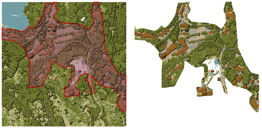
図 28.14 Clipping an input point cloud layer with a polygon coverage
パラメータ
基本パラメータ
ラベル |
名前 |
データ型 |
説明 |
|---|---|---|---|
入力レイヤ |
|
[point cloud] |
Input point cloud layer to clip |
Clipping polygons |
|
[ベクタ:ポリゴン] |
Polygon vector layer to use as coverage for clipping the points |
切り抜き結果 |
|
[point cloud] デフォルト: |
Specify the point cloud file to export the clipped points to. One of:
|
詳細パラメータ
ラベル |
名前 |
データ型 |
説明 |
|---|---|---|---|
フィルタ式 オプション |
|
[式] |
A PDAL expression for selecting a subset of features in the point cloud data |
Cropping extent オプション |
|
[範囲] |
A map extent for selecting a subset of features in the point cloud data 利用可能な方法:
|
出力
ラベル |
名前 |
データ型 |
説明 |
|---|---|---|---|
切り抜き結果 |
|
[ラスタ] |
Output point cloud whose features are the points within the coverage polygon layer. |
Python コード
Algorithm ID: pdal:clip
import processing
processing.run("algorithm_id", {parameter_dictionary})
algorithm id は、プロセシングツールボックス内でアルゴリズムにマウスカーソルを乗せた際に表示されるIDです。 parameter dictionary は、パラメータの「名前」とその値を指定するマッピング型です。Python コンソールからプロセシングアルゴリズムを実行する方法の詳細については、 プロセシングアルゴリズムをコンソールから使う を参照してください。
28.1.13.4. Create COPC
Creates the index for all the input point cloud files in a batch mode.
パラメータ
ラベル |
名前 |
データ型 |
説明 |
|---|---|---|---|
入力レイヤ |
|
[point cloud] [list] |
Input point cloud layers to create an index for |
出力フォルダ オプション |
|
[フォルダ] デフォルト: |
Specify the folder to create the new files in. One of:
|
出力
ラベル |
名前 |
データ型 |
説明 |
|---|---|---|---|
出力フォルダ |
|
[フォルダ] |
Output folder containing point cloud layers with accompanying COPC index files. |
Python コード
Algorithm ID: pdal:createcopc
import processing
processing.run("algorithm_id", {parameter_dictionary})
algorithm id は、プロセシングツールボックス内でアルゴリズムにマウスカーソルを乗せた際に表示されるIDです。 parameter dictionary は、パラメータの「名前」とその値を指定するマッピング型です。Python コンソールからプロセシングアルゴリズムを実行する方法の詳細については、 プロセシングアルゴリズムをコンソールから使う を参照してください。
28.1.13.5. Information
Outputs basic metadata from an input point cloud file.
Example of output information:
LAS           1.4
point format  6
count         56736130
scale         0.001 0.001 0.001
offset        431749.999 5440919.999 968.898
extent        431250 5440420 424.266
              432249.999 5441419.999 1513.531
crs           ETRS89 / UTM zone 34N (N-E) (EPSG:3046)  (vertical CRS missing!)
units         horizontal=metre  vertical=unknown

Attributes:
- X floating 8
- Y floating 8
- Z floating 8
- Intensity unsigned 2
- ReturnNumber unsigned 1
- NumberOfReturns unsigned 1
- ScanDirectionFlag unsigned 1
- EdgeOfFlightLine unsigned 1
- Classification unsigned 1
- ScanAngleRank floating 4
- UserData unsigned 1
- PointSourceId unsigned 2
- GpsTime floating 8
- ScanChannel unsigned 1
- ClassFlags unsigned 1
パラメータ
ラベル |
名前 |
データ型 |
説明 |
|---|---|---|---|
入力レイヤ |
|
[point cloud] |
Input point cloud layer to extract metadata information from |
出力ファイル |
|
[ファイル] デフォルト: |
Specify the file to store the metadata information. One of:
|
出力
ラベル |
名前 |
データ型 |
説明 |
|---|---|---|---|
出力ファイル |
|
[ベクタ] |
|
Python コード
Algorithm ID: pdal:info
import processing
processing.run("algorithm_id", {parameter_dictionary})
algorithm id は、プロセシングツールボックス内でアルゴリズムにマウスカーソルを乗せた際に表示されるIDです。 parameter dictionary は、パラメータの「名前」とその値を指定するマッピング型です。Python コンソールからプロセシングアルゴリズムを実行する方法の詳細については、 プロセシングアルゴリズムをコンソールから使う を参照してください。
28.1.13.6. 結合
Merges multiple point cloud files into a single one.
パラメータ
基本パラメータ
ラベル |
名前 |
データ型 |
説明 |
|---|---|---|---|
入力レイヤ |
|
[point cloud] [list] |
Input point cloud layers to merge into a single one |
出力レイヤ |
|
[point cloud] デフォルト: |
Specify the output point cloud merging input files. One of:
|
詳細パラメータ
ラベル |
名前 |
データ型 |
説明 |
|---|---|---|---|
フィルタ式 オプション |
|
[式] |
A PDAL expression for selecting a subset of features in the point cloud data |
Cropping extent オプション |
|
[範囲] |
A map extent for selecting a subset of features in the point cloud data 利用可能な方法:
|
出力
ラベル |
名前 |
データ型 |
説明 |
|---|---|---|---|
出力レイヤ |
|
[point cloud] |
Output point cloud layer merging all the input files. |
Python コード
Algorithm ID: pdal:merge
import processing
processing.run("algorithm_id", {parameter_dictionary})
algorithm id は、プロセシングツールボックス内でアルゴリズムにマウスカーソルを乗せた際に表示されるIDです。 parameter dictionary は、パラメータの「名前」とその値を指定するマッピング型です。Python コンソールからプロセシングアルゴリズムを実行する方法の詳細については、 プロセシングアルゴリズムをコンソールから使う を参照してください。
28.1.13.7. Reproject
Reprojects a point cloud to a different Coordinate Reference System (CRS).
参考
パラメータ
ラベル |
名前 |
データ型 |
説明 |
|---|---|---|---|
入力レイヤ |
|
[point cloud] |
Input point cloud layer to reproject to a different CRS |
ラスタのCRS |
|
[crs] |
The CRS to apply to the layer |
再投影したラスタファイル |
|
[point cloud] デフォルト: |
Specify the reprojected point cloud file. One of:
|
詳細パラメータ
ラベル |
名前 |
データ型 |
説明 |
|---|---|---|---|
Coordinate operation オプション |
|
[datum] |
The datum transformation to use to reproject the data between the origin and target systems. |
出力
ラベル |
名前 |
データ型 |
説明 |
|---|---|---|---|
REPROJECTED |
|
[point cloud] |
Output point cloud layer in the target CRS. |
Python コード
Algorithm ID: pdal:reproject
import processing
processing.run("algorithm_id", {parameter_dictionary})
algorithm id は、プロセシングツールボックス内でアルゴリズムにマウスカーソルを乗せた際に表示されるIDです。 parameter dictionary は、パラメータの「名前」とその値を指定するマッピング型です。Python コンソールからプロセシングアルゴリズムを実行する方法の詳細については、 プロセシングアルゴリズムをコンソールから使う を参照してください。
28.1.13.8. Thin (by sampling radius)
Creates a thinned version of the point cloud by performing sampling by distance point (reduces the number of points within a certain radius).
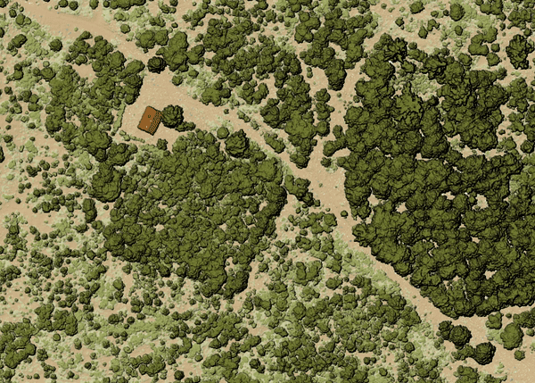
図 28.15 Thining point cloud (by sampling radius)
パラメータ
基本パラメータ
ラベル |
名前 |
データ型 |
説明 |
|---|---|---|---|
入力レイヤ |
|
[point cloud] |
Input point cloud layer to create a thinned version from |
Sampling radius (in map units) |
|
[数値] デフォルト: 1.0 |
Distance within which points are sampled to a unique point |
Thinned (by radius) |
|
[point cloud] デフォルト: |
Specify the output point cloud with reduced points. One of:
|
詳細パラメータ
ラベル |
名前 |
データ型 |
説明 |
|---|---|---|---|
フィルタ式 オプション |
|
[式] |
A PDAL expression for selecting a subset of features in the point cloud data |
Cropping extent オプション |
|
[範囲] |
A map extent for selecting a subset of features in the point cloud data 利用可能な方法:
|
出力
ラベル |
名前 |
データ型 |
説明 |
|---|---|---|---|
Thinned (by radius) |
|
[point cloud] |
Output point cloud layer with reduced points. |
Python コード
Algorithm ID: pdal:thinbyradius
import processing
processing.run("algorithm_id", {parameter_dictionary})
algorithm id は、プロセシングツールボックス内でアルゴリズムにマウスカーソルを乗せた際に表示されるIDです。 parameter dictionary は、パラメータの「名前」とその値を指定するマッピング型です。Python コンソールからプロセシングアルゴリズムを実行する方法の詳細については、 プロセシングアルゴリズムをコンソールから使う を参照してください。
28.1.13.9. Thin (by skipping points)
Creates a thinned version of the point cloud by keeping only every N-th point (reduces the number of points by skipping nearby points).
パラメータ
基本パラメータ
ラベル |
名前 |
データ型 |
説明 |
|---|---|---|---|
入力レイヤ |
|
[point cloud] |
Input point cloud layer to create a thinned version from |
Number of points to skip |
|
[数値] デフォルト: 1 |
Keep only every N-th point in the input layer |
Thinned (by decimation) |
|
[point cloud] デフォルト: |
Specify the output point cloud with reduced points. One of:
|
詳細パラメータ
ラベル |
名前 |
データ型 |
説明 |
|---|---|---|---|
フィルタ式 オプション |
|
[式] |
A PDAL expression for selecting a subset of features in the point cloud data |
Cropping extent オプション |
|
[範囲] |
A map extent for selecting a subset of features in the point cloud data 利用可能な方法:
|
出力
ラベル |
名前 |
データ型 |
説明 |
|---|---|---|---|
Thinned (by decimation) |
|
[point cloud] |
Output point cloud layer with reduced points. |
Python コード
Algorithm ID: pdal:thinbydecimate
import processing
processing.run("algorithm_id", {parameter_dictionary})
algorithm id は、プロセシングツールボックス内でアルゴリズムにマウスカーソルを乗せた際に表示されるIDです。 parameter dictionary は、パラメータの「名前」とその値を指定するマッピング型です。Python コンソールからプロセシングアルゴリズムを実行する方法の詳細については、 プロセシングアルゴリズムをコンソールから使う を参照してください。
28.1.13.10. Tile
Creates tiles from input point cloud files, recommended for best performance (in display or analysis) with such datasets in QGIS.
パラメータ
基本パラメータ
ラベル |
名前 |
データ型 |
説明 |
|---|---|---|---|
入力レイヤ |
|
[point cloud] [list] |
Input point cloud layers to create tiles from |
Tile length |
|
[数値] Default: 1000.0 |
Size of the edge of each generated tile |
出力フォルダ |
|
[フォルダ] デフォルト: |
Specify the folder to store the generated tiles. One of:
|
詳細パラメータ
ラベル |
名前 |
データ型 |
説明 |
|---|---|---|---|
Assign CRS オプション |
|
[crs] |
The CRS to apply to the layer |
出力
ラベル |
名前 |
データ型 |
説明 |
|---|---|---|---|
出力フォルダ |
|
[フォルダ] |
Output folder containing the tiles generated from input files. |
Python コード
Algorithm ID: pdal:tile
import processing
processing.run("algorithm_id", {parameter_dictionary})
algorithm id は、プロセシングツールボックス内でアルゴリズムにマウスカーソルを乗せた際に表示されるIDです。 parameter dictionary は、パラメータの「名前」とその値を指定するマッピング型です。Python コンソールからプロセシングアルゴリズムを実行する方法の詳細については、 プロセシングアルゴリズムをコンソールから使う を参照してください。