重要
翻訳は あなたが参加できる コミュニティの取り組みです。このページは現在 74.87% 翻訳されています。
28.1.14. Point Cloud Extraction
NEW in 3.32
28.1.14.1. トポロジカル境界
Exports a polygon file containing point cloud layer boundary. It may contain holes and it may be a multi-part polygon.
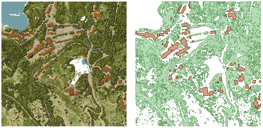
図 28.16 Extracting high vegetation and building polygons from an input point cloud layer
パラメータ
基本パラメータ
ラベル |
名前 |
データ型 |
説明 |
|---|---|---|---|
入力レイヤ |
|
[point cloud] |
Input point cloud layer to calculate boundary for |
Resolution of cells used to calculate boundary オプション |
|
[数値] |
Resolution of cells used to calculate boundary |
Minimal number of points in a cell to consider cell occupied オプション |
|
[数値] |
Minimal number of points in a cell to consider cell occupied |
トポロジカル境界 |
|
[ベクタ:ポリゴン] デフォルト: |
Specify the point cloud file to use as output. One of:
|
詳細パラメータ
ラベル |
名前 |
データ型 |
説明 |
|---|---|---|---|
フィルタ式 オプション |
|
[式] |
A PDAL expression for selecting a subset of features in the point cloud data |
Cropping extent オプション |
|
[範囲] |
A map extent for selecting a subset of features in the point cloud data 利用可能な方法:
|
出力
ラベル |
名前 |
データ型 |
説明 |
|---|---|---|---|
トポロジカル境界 |
|
[ベクタ:ポリゴン] |
Output polygon vector layer with the point cloud boundary.
Currently supported format is |
Python コード
Algorithm ID: pdal:boundary
import processing
processing.run("algorithm_id", {parameter_dictionary})
algorithm id は、プロセシングツールボックス内でアルゴリズムにマウスカーソルを乗せた際に表示されるIDです。 parameter dictionary は、パラメータの「名前」とその値を指定するマッピング型です。Python コンソールからプロセシングアルゴリズムを実行する方法の詳細については、 プロセシングアルゴリズムをコンソールから使う を参照してください。
28.1.14.2. Density
Exports a raster file based on the number of points within each raster cell - useful for quality checking of point cloud datasets.
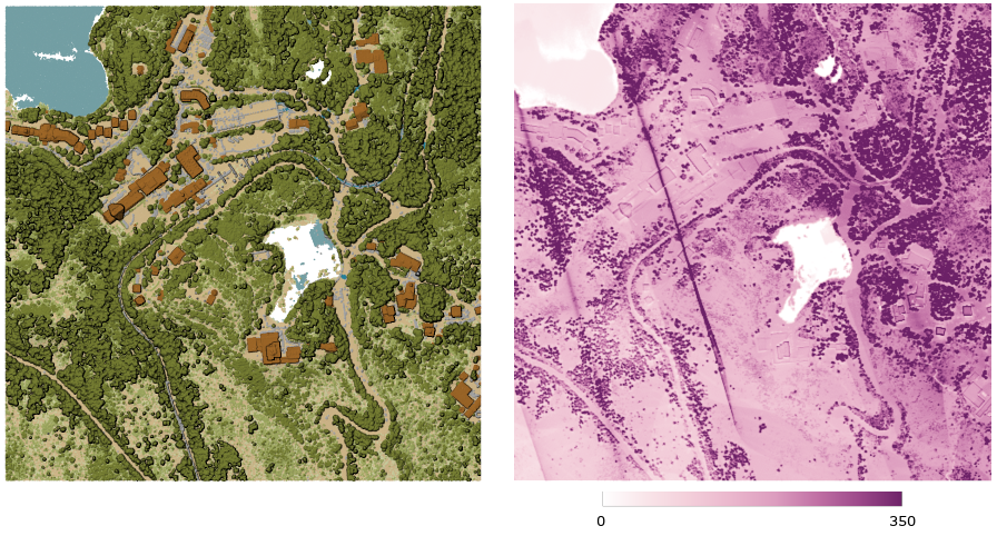
図 28.17 Point density (number of points per 2x2 m) as a raster
パラメータ
基本パラメータ
ラベル |
名前 |
データ型 |
説明 |
|---|---|---|---|
入力レイヤ |
|
[point cloud] |
Input point cloud layer to export |
Resolution of the density raster |
|
[数値] デフォルト: 1.0 |
Cell size of the output raster |
Tile size for parallel runs |
|
[数値] デフォルト: 1000 |
Size of the tiles to split the data into for parallel runs |
Density |
|
[ラスタ] デフォルト: |
Specify the raster file to export the data to. One of:
|
詳細パラメータ
ラベル |
名前 |
データ型 |
説明 |
|---|---|---|---|
フィルタ式 オプション |
|
[式] |
A PDAL expression for selecting a subset of features in the point cloud data |
Cropping extent オプション |
|
[範囲] |
A map extent for selecting a subset of features in the point cloud data 利用可能な方法:
|
X origin of a tile for parallel runs オプション |
|
[数値] |
|
Y origin of a tile for parallel runs オプション |
|
[数値] |
出力
ラベル |
名前 |
データ型 |
説明 |
|---|---|---|---|
Density |
|
[ラスタ] |
Output raster layer with number of points within each cell.
Currently supported format is |
Python コード
Algorithm ID: pdal:density
import processing
processing.run("algorithm_id", {parameter_dictionary})
algorithm id は、プロセシングツールボックス内でアルゴリズムにマウスカーソルを乗せた際に表示されるIDです。 parameter dictionary は、パラメータの「名前」とその値を指定するマッピング型です。Python コンソールからプロセシングアルゴリズムを実行する方法の詳細については、 プロセシングアルゴリズムをコンソールから使う を参照してください。
28.1.14.3. filter
Extracts point from the input point cloud which match PDAL expression and/or are inside of a cropping rectangle.
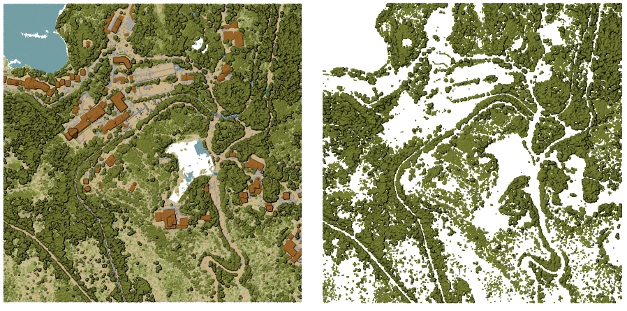
図 28.18 Filtering of high vegetation class from an input point cloud layer
パラメータ
ラベル |
名前 |
データ型 |
説明 |
|---|---|---|---|
入力レイヤ |
|
[point cloud] |
Input point cloud layer to export |
フィルタ式 オプション |
|
[式] |
A PDAL expression for selecting a subset of features in the point cloud data |
Cropping extent オプション |
|
[範囲] |
A map extent for selecting a subset of features in the point cloud data 利用可能な方法:
|
出力レイヤ |
|
[point cloud] デフォルト: |
Specify the point cloud file to export the data to. One of:
|
出力
ラベル |
名前 |
データ型 |
説明 |
|---|---|---|---|
出力レイヤ |
|
[point cloud] |
Output point cloud layer with the filtered features of the input point cloud layer.
Currently supported formats are |
Python コード
Algorithm ID: pdal:filter
import processing
processing.run("algorithm_id", {parameter_dictionary})
algorithm id は、プロセシングツールボックス内でアルゴリズムにマウスカーソルを乗せた際に表示されるIDです。 parameter dictionary は、パラメータの「名前」とその値を指定するマッピング型です。Python コンソールからプロセシングアルゴリズムを実行する方法の詳細については、 プロセシングアルゴリズムをコンソールから使う を参照してください。