Svarbu
Vertimas yra bendruomenės pastangos, prie kurių jūs galite prisijungti. Šis puslapis šiuo metu išverstas 95.72%.
24.1.14. Taškų masyvo ištraukimas
Pastaba
Šie algoritmai galimi tik jei QGIS naudoja PDAL bibliotekos 2.5.0 ar naujesnę versiją.
24.1.14.1. Ribos
Eksportuoja poligono failą su taškų masyvo sluoksnio ribomis. Jame gali būti skylės ir tai gali būti kelių dalių poligonas.
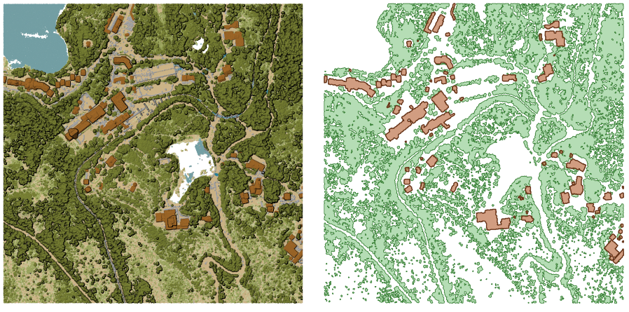
Fig. 24.16 Aukštos augmenijos ir pastatų poligonų ištraukimas iš įvesties taškų masyvo sluoksnio
Parametrai
Baziniai parametrai
Užrašas |
Pavadinimas |
Tipas |
Aprašymas |
|---|---|---|---|
Įvesties sluoksnis |
|
[taškų masyvas] |
Įvesties taškų masyvo sluoksnis ribų skaičiavimui |
Ribos skaičiavimui naudojamų celių rezoliucija Pasirinktinis |
|
[skaičius: slankaus kablelio] |
Ribos skaičiavimui naudojamų celių rezoliucija |
Minimalus skaičius taškų celėje, kad ji būtų laikoma užimta Pasirinktinis |
|
[skaičius: sveikas skaičius] |
Minimalus skaičius taškų celėje, kad ji būtų laikoma užimta |
Riba |
|
[vektorius: poligonas] Numatytas: |
Nurodykite taškų masyvo failą, kurį naudoti kaip išvestį. Vienas iš:
|
Išmanesni parametrai
Užrašas |
Pavadinimas |
Tipas |
Aprašymas |
|---|---|---|---|
Filtro išraiška Pasirinktinis |
|
[išraiška] |
PDAL išraiška parenkant taškų masyvo duomenų geoobjektų poaibį |
Apkarpymo apimtis Pasirinktinis |
|
[apimtis] |
Žemėlapio apimtis, parenkant taškų masyvo duomenų geoobjektų poaibį Galimi metodai yra:
|
Išvestys
Užrašas |
Pavadinimas |
Tipas |
Aprašymas |
|---|---|---|---|
Riba |
|
[vektorius: poligonas] |
Išvesties poligonų vektorinis sluoksnis su taškų masyvo ribomis. Šiuo metu palaikomas formatas yra |
Pythono kodas
Algoritmo ID: pdal:boundary
import processing
processing.run("algorithm_id", {parameter_dictionary})
algoritmo id rodomas, kai užvedate pelę virš algoritmo apdorojimo įrankinėje. parametrų žodynas teikia parametrų pavadinimus ir reikšmes. Daugiau informacijos apie tai, kaip vykdyti apdorojimo algoritmus Pythono konsolėje rasite skyriuje Using processing algorithms from the console.
24.1.14.2. Tankumas
Eksportuoja rastro failą pagal kiekvienoje rastro celėje esančių taškų skaičių - naudinga taškų masyvų duomenų aibių kokybės tikrinimui.
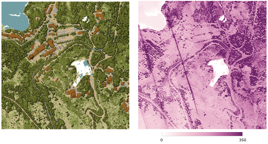
Fig. 24.17 Taškų tankumas (taškų skaičius 2x2 m) kaip rastras
Parametrai
Baziniai parametrai
Užrašas |
Pavadinimas |
Tipas |
Aprašymas |
|---|---|---|---|
Įvesties sluoksnis |
|
[taškų masyvas] |
Įvesties taškų masyvo sluoksnis eksportavimui |
Tankio rastro rezoliucija |
|
[skaičius: slankaus kablelio] Numatytas: 1.0 |
Išvesties rastro celės dydis |
Paralelinio vykdymo kaladėlės dydis |
|
[skaičius: sveikas skaičius] Numatytas: 1000 |
Kaladėlių dydis, dalinant duomenis paraleliniam skaičiavimui |
Tankumas |
|
[rastras] Numatytas: |
Nurodykite rastro failą, į kurį eksportuoti duomenis. Vienas iš:
|
Išmanesni parametrai
Užrašas |
Pavadinimas |
Tipas |
Aprašymas |
|---|---|---|---|
Filtro išraiška Pasirinktinis |
|
[išraiška] |
PDAL išraiška parenkant taškų masyvo duomenų geoobjektų poaibį |
Apkarpymo apimtis Pasirinktinis |
|
[apimtis] |
Žemėlapio apimtis, parenkant taškų masyvo duomenų geoobjektų poaibį Galimi metodai yra:
|
Paralelinio vykdymo kaladėlių X pradžia Pasirinktinis |
|
[skaičius: slankaus kablelio] |
|
Paralelinio vykdymo kaladėlių Y pradžia Pasirinktinis |
|
[skaičius: slankaus kablelio] |
Išvestys
Užrašas |
Pavadinimas |
Tipas |
Aprašymas |
|---|---|---|---|
Tankumas |
|
[rastras] |
Išvesties rastro sluoksnis su kiekvienoje celėje esančių taškų skaičiumi. Šiuo metu palaikomas formatas yra |
Pythono kodas
Algoritmo ID: pdal:density
import processing
processing.run("algorithm_id", {parameter_dictionary})
algoritmo id rodomas, kai užvedate pelę virš algoritmo apdorojimo įrankinėje. parametrų žodynas teikia parametrų pavadinimus ir reikšmes. Daugiau informacijos apie tai, kaip vykdyti apdorojimo algoritmus Pythono konsolėje rasite skyriuje Using processing algorithms from the console.
24.1.14.3. Filter
Extracts point from the input point cloud which match PDAL expression and/or are inside of a cropping rectangle.
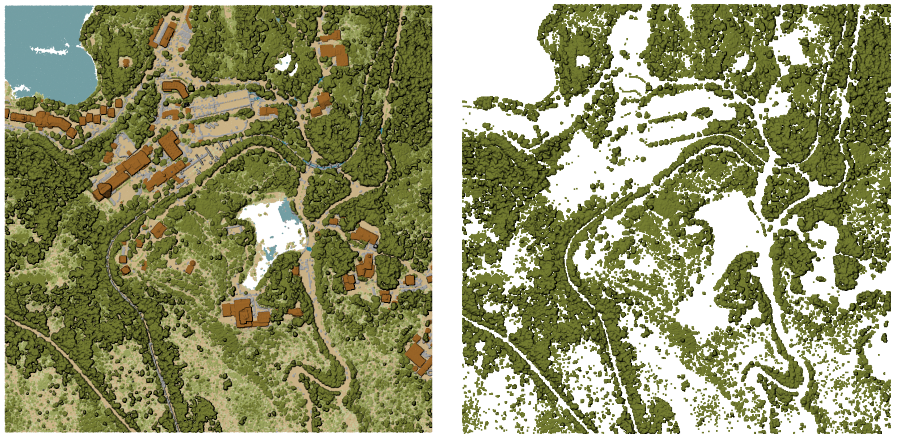
Fig. 24.18 Filtering of high vegetation class from an input point cloud layer
Parametrai
Užrašas |
Pavadinimas |
Tipas |
Aprašymas |
|---|---|---|---|
Įvesties sluoksnis |
|
[taškų masyvas] |
Įvesties taškų masyvo sluoksnis eksportavimui |
Filtro išraiška Pasirinktinis |
|
[išraiška] |
PDAL išraiška parenkant taškų masyvo duomenų geoobjektų poaibį |
Apkarpymo apimtis Pasirinktinis |
|
[apimtis] |
Žemėlapio apimtis, parenkant taškų masyvo duomenų geoobjektų poaibį Galimi metodai yra:
|
Filtered |
|
[taškų masyvas] Numatytas: |
Specify the point cloud file to export the data to. One of:
|
Išvestys
Užrašas |
Pavadinimas |
Tipas |
Aprašymas |
|---|---|---|---|
Filtered |
|
[taškų masyvas] |
Output point cloud layer with the filtered features of the input point cloud layer.
Currently supported formats are |
Pythono kodas
Algorithm ID: pdal:filter
import processing
processing.run("algorithm_id", {parameter_dictionary})
algoritmo id rodomas, kai užvedate pelę virš algoritmo apdorojimo įrankinėje. parametrų žodynas teikia parametrų pavadinimus ir reikšmes. Daugiau informacijos apie tai, kaip vykdyti apdorojimo algoritmus Pythono konsolėje rasite skyriuje Using processing algorithms from the console.