Svarbu
Vertimas yra bendruomenės pastangos, prie kurių jūs galite prisijungti. Šis puslapis šiuo metu išverstas 85.36%.
24.1.25. Vektorių parinkimas
24.1.25.1. Ištraukti pagal atributą
Iš įvesties sluoksnio sukuria du vektorinius sluoksnius: vieną tik su atitinkančiais geoobjektais ir antrą su neatitinkančiais geoobjektais.
Geoobjektų skirstymo į gaunamus sluoksnius kriterijus remiasi įvesties sluoksnio atributo reikšmėmis.
Taip pat žiūrėkite
Parametrai
Užrašas |
Pavadinimas |
Tipas |
Aprašymas |
|---|---|---|---|
Įvesties sluoksnis |
|
[vektorius: bet koks] |
Sluoksnis, iš kurio ištraukiami geoobjektai. |
Parinkimo atributas |
|
[lentelės laukas: bet koks] |
Sluoksnio filtravimo laukas |
Veiksmas |
|
[sąrašas] Numatytas: 0 |
Yra daug skirtingų galimų veiksmų:
|
Reikšmė Pasirinktinis |
|
[tekstas] |
Įvertinama reikšmė |
Ištraukti (atributas) |
|
[toks pat, kaip įvestis] Numatytas: |
Nurodykite išvesties vektorinį sluoksnį atitinkantiems geoobjektams. Vienas iš:
Čia taipogi galima pakeisti failo koduotę. |
Ištraukti (neatitinkantys) |
|
[toks pat, kaip įvestis] Numatytas: |
Nurodykite išvesties vektorinį sluoksnį neatitinkantiems geoobjektams. Vienas iš:
Čia taipogi galima pakeisti failo koduotę. |
Išvestys
Užrašas |
Pavadinimas |
Tipas |
Aprašymas |
|---|---|---|---|
Ištraukti (atributas) |
|
[toks pat, kaip įvestis] |
Vektorinis sluoksnis su atitinkančiais geoobjektais iš įvesties sluoksnio |
Ištraukti (neatitinkantys) |
|
[toks pat, kaip įvestis] |
Vektorinis sluoksnis su neatitinkančiais geoobjektais iš įvesties sluoksnio |
Pythono kodas
Algoritmo ID: native:extractbyattribute
import processing
processing.run("algorithm_id", {parameter_dictionary})
algoritmo id rodomas, kai užvedate pelę virš algoritmo apdorojimo įrankinėje. parametrų žodynas teikia parametrų pavadinimus ir reikšmes. Daugiau informacijos apie tai, kaip vykdyti apdorojimo algoritmus Pythono konsolėje rasite skyriuje Using processing algorithms from the console.
24.1.25.2. Ištraukti pagal išraišką
Iš įvesties sluoksnio sukuria du vektorinius sluoksnius: vieną tik su atitinkančiais geoobjektais ir antrą su neatitinkančiais geoobjektais.
Geoobjektų pridėjimo į rezultato sluoksnį kriterijus remiasi QGIS išraiška. Daugiau informacijos apie išraiškas rasite skyriuje Išraiškos.
Taip pat žiūrėkite
Parametrai
Užrašas |
Pavadinimas |
Tipas |
Aprašymas |
|---|---|---|---|
Įvesties sluoksnis |
|
[vektorius: bet koks] |
Įvesties vektorinis sluoksnis |
Išraiška |
|
[išraiška] |
Vektorinio sluoksnio filtravimo išraiška |
Atitinkantys geoobjektai |
|
[toks pat, kaip įvestis] Numatytas: |
Nurodykite išvesties vektorinį sluoksnį atitinkantiems geoobjektams. Vienas iš:
Čia taipogi galima pakeisti failo koduotę. |
Neatitinkantys |
|
[toks pat, kaip įvestis] Numatytas: |
Nurodykite išvesties vektorinį sluoksnį neatitinkantiems geoobjektams. Vienas iš:
Čia taipogi galima pakeisti failo koduotę. |
Išvestys
Užrašas |
Pavadinimas |
Tipas |
Aprašymas |
|---|---|---|---|
Atitinkantys geoobjektai |
|
[toks pat, kaip įvestis] |
Vektorinis sluoksnis su atitinkančiais geoobjektais iš įvesties sluoksnio |
Neatitinkantys |
|
[toks pat, kaip įvestis] |
Vektorinis sluoksnis su neatitinkančiais geoobjektais iš įvesties sluoksnio |
Pythono kodas
Algoritmo ID: native:extractbyexpression
import processing
processing.run("algorithm_id", {parameter_dictionary})
algoritmo id rodomas, kai užvedate pelę virš algoritmo apdorojimo įrankinėje. parametrų žodynas teikia parametrų pavadinimus ir reikšmes. Daugiau informacijos apie tai, kaip vykdyti apdorojimo algoritmus Pythono konsolėje rasite skyriuje Using processing algorithms from the console.
24.1.25.3. Ištraukti pagal vietą
Sukuria naują vektorinį sluoksnį, kuriame yra tik atitinkantys įvesties sluoksnio geoobjektai.
Geoobjektų pridėjimo į rezultatų sluoksnį kriterijus remiasi erdviniu ryšiu tarp kiekvieno geoobjekto ir geoobjektų papildomame sluoksnyje.
Taip pat žiūrėkite
Erdvinių ryšių tyrinėjimas
Geometriniai predikatai yra funkcijos, kurios naudojamos nustatant, kokį erdvinį ryšį geoobjektas turi su kitu, lyginant ar ir kaip jų geometrijos dalinasi erdvės dalimi.
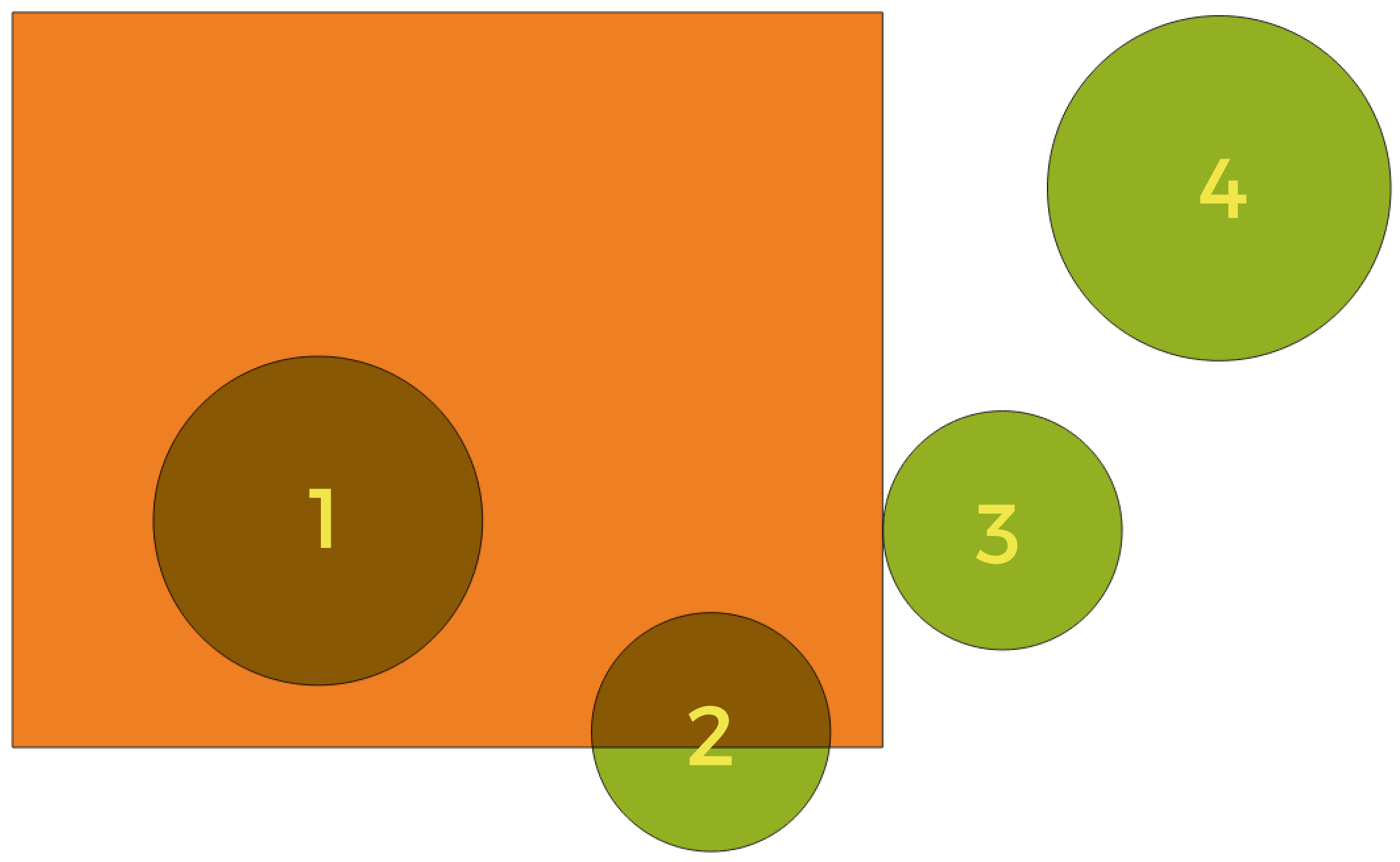
Fig. 24.133 Erdvinių ryšių tarp sluoksnių paieška
Naudojant aukščiau pateiktą iliustraciją, mes ieškome žalių apskritimų, erdviškai lygindami juos su oranžiniu stačiakampiu geoobjektus. Galimi geometriniai predikatai yra:
- Susikerta
Tikrina, ar viena geometrija kerta kitą. Grąžina 1 (true), jei geometrijos erdviškai kertasi (dalinasi kažkokia erdvės dalimi - persidengia arba liečia) ir 0, jei to nėra. Iliustracijoje aukščiau True bus grąžinama apskritimams 1, 2 ir 3.
- Įtraukia
Grąžina 1 (true) tada ir tik tada, jei nei vienas b taškas nėra už a ribų, ir bent vienas b vidaus taškas yra a viduje. Iliustracijoje nei vienas apskritimas nebūtų grąžintas, bet stačiakampis būtų, jei jūs ieškotumėte atvirkščiai, nes pilnai stačiakampyje yra 1 apskritimas. Tai yra priešingybė yra viduje.
- Atskiras
Grąžina 1 (true), jei geometrijos nesidalina jokia erdvės dalimi (nėra persidengimo, nėra susilietimo). Grąžinamas tik 4 apskritimas.
- Lygūs
Grąžina 1 (true), tada ir tik tada, jei geometrijos yra lygiai tokios pačios. Negrąžinami jokie apskritimai.
- Liečia
Tikrina, ar geometrija liečia kitą geometriją. Grąžina 1 (true), jei geometrijos turi bent vieną bendrą tašką, bet jų vidus nepersidengia. Grąžinamas tik 3 apskritimas.
- Persidengia
Tikrina, ar viena geometrija persidengia su kita. Grąžina 1 (true), jei geometrijos dalinasi erdve, turi tokius pačius matmenis, bet nei viena iš jų nėra pilnai kitoje. Grąžinamas tik 2 apskritimas.
- Yra viduje
Tikrina, ar geometrija yra kitos viduje. Grąžina 1 (true), jei geometrija a yra pilnai geometrijos b viduje. Grąžinamas tik apskritimas 1.
- Kerta
Grąžina 1 (true), jei pateiktos geometrijos turi kelis, bet ne visus, bendrus vidaus taškus ir jų susikirtimas turi mažiau matmenų nei daugiausiai matmenų turinti geometrija. Pavyzdžiui, linijos ir poligono susikirtimas bus linija (true). Poligono ir poligono susikirtimas yra poligonas (false). Iliustracijoje nebūtų grąžinamas nei vienas apskritimas.
Parametrai
Užrašas |
Pavadinimas |
Tipas |
Aprašymas |
|---|---|---|---|
Ištraukti geoobjektus iš |
|
[vektorius: geometrija] |
Įvesties vektorinis sluoksnis |
Kur geoobjektai (geometrinis predikatas) |
|
[enumeration] [list] Numatytas: [0] |
Tipas erdvinio ryšio, kurį įvesties geoobjektas turi turėti su susikertančiu objektu, kad jis būtų parinktas. Vienas ar daugiau iš:
Jei parinkta daugiau nei viena sąlyga, bent viena iš jų (OR veiksmas) turi būti tenkinama, kad geoobjektas būtų ištrauktas. |
Lyginant geoobjektus iš |
|
[vektorius: geometrija] |
Susidengimo vektorinis sluoksnis |
Ištrauktas (vieta) |
|
[toks pat, kaip įvestis] Numatytas: |
Nurodykite išvesties vektorinį sluoksnį geoobjektams, kurie turi pasirinktą erdvinį ryšį(ius) su vienu ar daugiau geobjektų iš palyginimo sluoksnio. Vienas iš:
Čia taipogi galima pakeisti failo koduotę. |
Išvestys
Užrašas |
Pavadinimas |
Tipas |
Aprašymas |
|---|---|---|---|
Ištrauktas (vieta) |
|
[toks pat, kaip įvestis] |
Vektorinis sluoksnis su geoobjektais iš įvesties sluoksnio, kurie turi pasirinktą erdvinį ryšį(ius) su vienu ar daugiau geoobjektų iš palyginimo sluoksnio. |
Pythono kodas
Algoritmo ID: native:extractbylocation
import processing
processing.run("algorithm_id", {parameter_dictionary})
algoritmo id rodomas, kai užvedate pelę virš algoritmo apdorojimo įrankinėje. parametrų žodynas teikia parametrų pavadinimus ir reikšmes. Daugiau informacijos apie tai, kaip vykdyti apdorojimo algoritmus Pythono konsolėje rasite skyriuje Using processing algorithms from the console.
24.1.25.4. Ištraukti pagal atstumą
Sukuria naują vektorinį sluoksnį, kuriame yra tik atitinkantys įvesties sluoksnio geoobjektai. Geoobjektai nukopijuojami kai jie yra nurodytu atstumu nuo papildomo atskaitos sluoksnio geoobjektų.
Taip pat žiūrėkite
Parametrai
Užrašas |
Pavadinimas |
Tipas |
Aprašymas |
|---|---|---|---|
Ištraukti geoobjektus iš |
|
[vektorius: geometrija] |
Įvesties vektorinis sluoksnis, iš kurio reikia kopijuoti geoobjektus |
Lyginant geoobjektus iš |
|
[vektorius: geometrija] |
Vektorinis sluoksnis, kurio geoobjektų artumas yra naudojamas |
Kur geoobjektai yra arčiau nei |
|
[skaičius: slankaus kablelio] Numatytas: 100.0 |
Maksimalus atstumas nuo atskaitos geoobjektų parenkant įvesties geoobjektus |
Keisti dabartinį parinkimą |
|
[sąrašas] Numatytas: 0 |
Kaip valdyti algoritmo parinkimą. Vienas iš:
|
Ištrauktas (vieta) |
|
[toks pat, kaip įvestis] Numatytas: |
Nurodykite išvesties vektorinį sluoksnį geoobjektams, kurie yra arčiau nei nurodytas atstumas nuo atskaitos geoobjektų. Vienas iš:
Čia taipogi galima pakeisti failo koduotę. |

Išvestys
Užrašas |
Pavadinimas |
Tipas |
Aprašymas |
|---|---|---|---|
Ištrauktas (vieta) |
|
[toks pat, kaip įvestis] |
Vektorinis sluoksnis su įvesties sluoksnio geoobjektais, kurie atitinka atstumo nuo atskaitos geoobjektų sąlygą |
Pythono kodas
Algoritmo ID: native:extractwithindistance
import processing
processing.run("algorithm_id", {parameter_dictionary})
algoritmo id rodomas, kai užvedate pelę virš algoritmo apdorojimo įrankinėje. parametrų žodynas teikia parametrų pavadinimus ir reikšmes. Daugiau informacijos apie tai, kaip vykdyti apdorojimo algoritmus Pythono konsolėje rasite skyriuje Using processing algorithms from the console.
24.1.25.5. Filter by geometry type
Filters features by their geometry type. Incoming features will be directed to different outputs based on whether they have a point, line or polygon geometry.
Parametrai
Užrašas |
Pavadinimas |
Tipas |
Aprašymas |
|---|---|---|---|
Įvesties sluoksnis |
|
[vektorius: bet koks] |
Layer to evaluate |
Išvestys
Užrašas |
Pavadinimas |
Tipas |
Aprašymas |
|---|---|---|---|
Point features Pasirinktinis |
|
[vector: point] |
Layer with points |
Line features Pasirinktinis |
|
[vektorius: linija] |
Layer with lines |
Polygon features Pasirinktinis |
|
[vektorius: poligonas] |
Layer with polygons |
Features with no geometry Pasirinktinis |
|
[vektorius: lentelė] |
Geometry-less vector layer |
Pythono kodas
Algorithm ID: native:filterbygeometry
import processing
processing.run("algorithm_id", {parameter_dictionary})
algoritmo id rodomas, kai užvedate pelę virš algoritmo apdorojimo įrankinėje. parametrų žodynas teikia parametrų pavadinimus ir reikšmes. Daugiau informacijos apie tai, kaip vykdyti apdorojimo algoritmus Pythono konsolėje rasite skyriuje Using processing algorithms from the console.
24.1.25.6. Random extract
Takes a vector layer and generates a new one that contains only a subset of the features in the input layer.
The subset is defined randomly, based on feature IDs, using a percentage or count value to define the total number of features in the subset.
Įspėjimas
This algorithm drops existing primary keys or FID values and regenerate them in output layers.
Taip pat žiūrėkite
Parametrai
Užrašas |
Pavadinimas |
Tipas |
Aprašymas |
|---|---|---|---|
Įvesties sluoksnis |
|
[vektorius: bet koks] |
Source vector layer to select the features from |
Metodas |
|
[sąrašas] Numatytas: 0 |
Random selection methods. One of:
|
Number/percentage of selected features |
|
[skaičius: sveikas skaičius] Numatytas: 10 |
Number or percentage of features to select |
Extracted (random) |
|
[toks pat, kaip įvestis] Numatytas: |
Specify the output vector layer for the randomly selected features. One of:
Čia taipogi galima pakeisti failo koduotę. |
Išvestys
Užrašas |
Pavadinimas |
Tipas |
Aprašymas |
|---|---|---|---|
Extracted (random) |
|
[toks pat, kaip įvestis] |
Vector layer containing randomly selected features from the input layer |
Pythono kodas
Algorithm ID: native:randomextract
import processing
processing.run("algorithm_id", {parameter_dictionary})
algoritmo id rodomas, kai užvedate pelę virš algoritmo apdorojimo įrankinėje. parametrų žodynas teikia parametrų pavadinimus ir reikšmes. Daugiau informacijos apie tai, kaip vykdyti apdorojimo algoritmus Pythono konsolėje rasite skyriuje Using processing algorithms from the console.
24.1.25.7. Random extract within subsets
Takes a vector layer and generates a new one that contains only a subset of the features in the input layer.
The subset is defined randomly, based on feature IDs, using a percentage or count value to define the total number of features in the subset. The percentage/count value is not applied to the whole layer, but instead to each category. Categories are defined according to a given attribute.
Taip pat žiūrėkite
Parametrai
Užrašas |
Pavadinimas |
Tipas |
Aprašymas |
|---|---|---|---|
Įvesties sluoksnis |
|
[vektorius: bet koks] |
Vector layer to select the features from |
ID field |
|
[lentelės laukas: bet koks] |
Category of the source vector layer to select the features from |
Metodas |
|
[sąrašas] Numatytas: 0 |
Random selection method. One of:
|
Number/percentage of selected features |
|
[skaičius: sveikas skaičius] Numatytas: 10 |
Number or percentage of features to select |
Extracted (random stratified) |
|
[toks pat, kaip įvestis] Numatytas: |
Specify the output vector layer for the randomly selected features. One of:
Čia taipogi galima pakeisti failo koduotę. |
Išvestys
Užrašas |
Pavadinimas |
Tipas |
Aprašymas |
|---|---|---|---|
Extracted (random stratified) |
|
[toks pat, kaip įvestis] |
Vector layer containing randomly selected features from the input layer |
Pythono kodas
Algorithm ID: qgis:randomextractwithinsubsets
import processing
processing.run("algorithm_id", {parameter_dictionary})
algoritmo id rodomas, kai užvedate pelę virš algoritmo apdorojimo įrankinėje. parametrų žodynas teikia parametrų pavadinimus ir reikšmes. Daugiau informacijos apie tai, kaip vykdyti apdorojimo algoritmus Pythono konsolėje rasite skyriuje Using processing algorithms from the console.
24.1.25.8. Random selection
Takes a vector layer and selects a subset of its features. No new layer is generated by this algorithm.
The subset is defined randomly, based on feature IDs, using a percentage or count value to define the total number of features in the subset.
Numatytas meniu:
Taip pat žiūrėkite
Parametrai
Užrašas |
Pavadinimas |
Tipas |
Aprašymas |
|---|---|---|---|
Įvesties sluoksnis |
|
[vektorius: bet koks] |
Vector layer for the selection |
Metodas |
|
[sąrašas] Numatytas: 0 |
Random selection method. One of:
|
Number/percentage of selected features |
|
[skaičius: sveikas skaičius] Numatytas: 10 |
Number or percentage of features to select |
Išvestys
Užrašas |
Pavadinimas |
Tipas |
Aprašymas |
|---|---|---|---|
Įvesties sluoksnis |
|
[toks pat, kaip įvestis] |
The input layer with features selected |
Pythono kodas
Algorithm ID: qgis:randomselection
import processing
processing.run("algorithm_id", {parameter_dictionary})
algoritmo id rodomas, kai užvedate pelę virš algoritmo apdorojimo įrankinėje. parametrų žodynas teikia parametrų pavadinimus ir reikšmes. Daugiau informacijos apie tai, kaip vykdyti apdorojimo algoritmus Pythono konsolėje rasite skyriuje Using processing algorithms from the console.
24.1.25.9. Random selection within subsets
Takes a vector layer and selects a subset of its features. No new layer is generated by this algorithm.
The subset is defined randomly, based on feature IDs, using a percentage or count value to define the total number of features in the subset.
The percentage/count value is not applied to the whole layer, but instead to each category.
Categories are defined according to a given attribute, which is also specified as an input parameter for the algorithm.
No new outputs are created.
Numatytas meniu:
Taip pat žiūrėkite
Parametrai
Užrašas |
Pavadinimas |
Tipas |
Aprašymas |
|---|---|---|---|
Įvesties sluoksnis |
|
[vektorius: bet koks] |
Vector layer to select features in |
ID field |
|
[lentelės laukas: bet koks] |
Category of the input layer to select the features from |
Metodas |
|
[sąrašas] Numatytas: 0 |
Random selection method. One of:
|
Number/percentage of selected features |
|
[skaičius: sveikas skaičius] Numatytas: 10 |
Number or percentage of features to select |
Išvestys
Užrašas |
Pavadinimas |
Tipas |
Aprašymas |
|---|---|---|---|
Įvesties sluoksnis |
|
[toks pat, kaip įvestis] |
The input layer with features selected |
Pythono kodas
Algorithm ID: qgis:randomselectionwithinsubsets
import processing
processing.run("algorithm_id", {parameter_dictionary})
algoritmo id rodomas, kai užvedate pelę virš algoritmo apdorojimo įrankinėje. parametrų žodynas teikia parametrų pavadinimus ir reikšmes. Daugiau informacijos apie tai, kaip vykdyti apdorojimo algoritmus Pythono konsolėje rasite skyriuje Using processing algorithms from the console.
24.1.25.10. Select by attribute
Creates a selection in a vector layer.
The criteria for selecting features is based on the values of an attribute from the input layer.
Taip pat žiūrėkite
Parametrai
Užrašas |
Pavadinimas |
Tipas |
Aprašymas |
|---|---|---|---|
Įvesties sluoksnis |
|
[vektorius: bet koks] |
Vector layer to select features in |
Parinkimo atributas |
|
[lentelės laukas: bet koks] |
Sluoksnio filtravimo laukas |
Veiksmas |
|
[sąrašas] Numatytas: 0 |
Yra daug skirtingų galimų veiksmų:
|
Reikšmė Pasirinktinis |
|
[tekstas] |
Įvertinama reikšmė |
Keisti dabartinį parinkimą |
|
[sąrašas] Numatytas: 0 |
Kaip valdyti algoritmo parinkimą. Vienas iš:
|
Išvestys
Užrašas |
Pavadinimas |
Tipas |
Aprašymas |
|---|---|---|---|
Įvesties sluoksnis |
|
[toks pat, kaip įvestis] |
The input layer with features selected |
Pythono kodas
Algorithm ID: qgis:selectbyattribute
import processing
processing.run("algorithm_id", {parameter_dictionary})
algoritmo id rodomas, kai užvedate pelę virš algoritmo apdorojimo įrankinėje. parametrų žodynas teikia parametrų pavadinimus ir reikšmes. Daugiau informacijos apie tai, kaip vykdyti apdorojimo algoritmus Pythono konsolėje rasite skyriuje Using processing algorithms from the console.
24.1.25.11. Select by expression
Creates a selection in a vector layer.
The criteria for selecting features is based on a QGIS expression. For more information about expressions see the Išraiškos.
Taip pat žiūrėkite
Parametrai
Užrašas |
Pavadinimas |
Tipas |
Aprašymas |
|---|---|---|---|
Įvesties sluoksnis |
|
[vektorius: bet koks] |
Įvesties vektorinis sluoksnis |
Išraiška |
|
[išraiška] |
Expression to filter the input layer |
Keisti dabartinį parinkimą |
|
[sąrašas] Numatytas: 0 |
Kaip valdyti algoritmo parinkimą. Vienas iš:
|
Išvestys
Užrašas |
Pavadinimas |
Tipas |
Aprašymas |
|---|---|---|---|
Įvesties sluoksnis |
|
[toks pat, kaip įvestis] |
The input layer with features selected |
Pythono kodas
Algorithm ID: qgis:selectbyexpression
import processing
processing.run("algorithm_id", {parameter_dictionary})
algoritmo id rodomas, kai užvedate pelę virš algoritmo apdorojimo įrankinėje. parametrų žodynas teikia parametrų pavadinimus ir reikšmes. Daugiau informacijos apie tai, kaip vykdyti apdorojimo algoritmus Pythono konsolėje rasite skyriuje Using processing algorithms from the console.
24.1.25.12. Select by location
Creates a selection in a vector layer.
The criteria for selecting features is based on the spatial relationship between each feature and the features in an additional layer.
Numatytas meniu:
Taip pat žiūrėkite
Erdvinių ryšių tyrinėjimas
Geometriniai predikatai yra funkcijos, kurios naudojamos nustatant, kokį erdvinį ryšį geoobjektas turi su kitu, lyginant ar ir kaip jų geometrijos dalinasi erdvės dalimi.
Fig. 24.134 Erdvinių ryšių tarp sluoksnių paieška
Naudojant aukščiau pateiktą iliustraciją, mes ieškome žalių apskritimų, erdviškai lygindami juos su oranžiniu stačiakampiu geoobjektus. Galimi geometriniai predikatai yra:
- Susikerta
Tikrina, ar viena geometrija kerta kitą. Grąžina 1 (true), jei geometrijos erdviškai kertasi (dalinasi kažkokia erdvės dalimi - persidengia arba liečia) ir 0, jei to nėra. Iliustracijoje aukščiau True bus grąžinama apskritimams 1, 2 ir 3.
- Įtraukia
Grąžina 1 (true) tada ir tik tada, jei nei vienas b taškas nėra už a ribų, ir bent vienas b vidaus taškas yra a viduje. Iliustracijoje nei vienas apskritimas nebūtų grąžintas, bet stačiakampis būtų, jei jūs ieškotumėte atvirkščiai, nes pilnai stačiakampyje yra 1 apskritimas. Tai yra priešingybė yra viduje.
- Atskiras
Grąžina 1 (true), jei geometrijos nesidalina jokia erdvės dalimi (nėra persidengimo, nėra susilietimo). Grąžinamas tik 4 apskritimas.
- Lygūs
Grąžina 1 (true), tada ir tik tada, jei geometrijos yra lygiai tokios pačios. Negrąžinami jokie apskritimai.
- Liečia
Tikrina, ar geometrija liečia kitą geometriją. Grąžina 1 (true), jei geometrijos turi bent vieną bendrą tašką, bet jų vidus nepersidengia. Grąžinamas tik 3 apskritimas.
- Persidengia
Tikrina, ar viena geometrija persidengia su kita. Grąžina 1 (true), jei geometrijos dalinasi erdve, turi tokius pačius matmenis, bet nei viena iš jų nėra pilnai kitoje. Grąžinamas tik 2 apskritimas.
- Yra viduje
Tikrina, ar geometrija yra kitos viduje. Grąžina 1 (true), jei geometrija a yra pilnai geometrijos b viduje. Grąžinamas tik apskritimas 1.
- Kerta
Grąžina 1 (true), jei pateiktos geometrijos turi kelis, bet ne visus, bendrus vidaus taškus ir jų susikirtimas turi mažiau matmenų nei daugiausiai matmenų turinti geometrija. Pavyzdžiui, linijos ir poligono susikirtimas bus linija (true). Poligono ir poligono susikirtimas yra poligonas (false). Iliustracijoje nebūtų grąžinamas nei vienas apskritimas.
Parametrai
Užrašas |
Pavadinimas |
Tipas |
Aprašymas |
|---|---|---|---|
Select features from |
|
[vektorius: geometrija] |
Įvesties vektorinis sluoksnis |
Kur geoobjektai (geometrinis predikatas) |
|
[enumeration] [list] Numatytas: [0] |
Tipas erdvinio ryšio, kurį įvesties geoobjektas turi turėti su susikertančiu objektu, kad jis būtų parinktas. Vienas ar daugiau iš:
Jei parinkta daugiau nei viena sąlyga, bent viena iš jų (OR veiksmas) turi būti tenkinama, kad geoobjektas būtų ištrauktas. |
Lyginant geoobjektus iš |
|
[vektorius: geometrija] |
Susidengimo vektorinis sluoksnis |
Keisti dabartinį parinkimą |
|
[sąrašas] Numatytas: 0 |
Kaip valdyti algoritmo parinkimą. Vienas iš:
|
Išvestys
Užrašas |
Pavadinimas |
Tipas |
Aprašymas |
|---|---|---|---|
Įvesties sluoksnis |
|
[toks pat, kaip įvestis] |
The input layer with features selected |
Pythono kodas
Algorithm ID: native:selectbylocation
import processing
processing.run("algorithm_id", {parameter_dictionary})
algoritmo id rodomas, kai užvedate pelę virš algoritmo apdorojimo įrankinėje. parametrų žodynas teikia parametrų pavadinimus ir reikšmes. Daugiau informacijos apie tai, kaip vykdyti apdorojimo algoritmus Pythono konsolėje rasite skyriuje Using processing algorithms from the console.
24.1.25.13. Select within distance
creates a selection in a vector layer. Features are selected wherever they are within the specified maximum distance from the features in an additional reference layer.
Taip pat žiūrėkite
Parametrai
Užrašas |
Pavadinimas |
Tipas |
Aprašymas |
|---|---|---|---|
Select features from |
|
[vektorius: geometrija] |
Input vector layer to select features from |
Lyginant geoobjektus iš |
|
[vektorius: geometrija] |
Vektorinis sluoksnis, kurio geoobjektų artumas yra naudojamas |
Kur geoobjektai yra arčiau nei |
|
[skaičius: slankaus kablelio] Numatytas: 100.0 |
The maximum distance around reference features to select input features |
Keisti dabartinį parinkimą |
|
[sąrašas] Numatytas: 0 |
Kaip valdyti algoritmo parinkimą. Vienas iš:
|
Išvestys
Užrašas |
Pavadinimas |
Tipas |
Aprašymas |
|---|---|---|---|
Įvesties sluoksnis |
|
[toks pat, kaip įvestis] |
The input layer with features selected |
Pythono kodas
Algorithm ID: native:selectwithindistance
import processing
processing.run("algorithm_id", {parameter_dictionary})
algoritmo id rodomas, kai užvedate pelę virš algoritmo apdorojimo įrankinėje. parametrų žodynas teikia parametrų pavadinimus ir reikšmes. Daugiau informacijos apie tai, kaip vykdyti apdorojimo algoritmus Pythono konsolėje rasite skyriuje Using processing algorithms from the console.