Svarbu
Vertimas yra bendruomenės pastangos, prie kurių jūs galite prisijungti. Šis puslapis šiuo metu išverstas 75.85%.
24.1.23. Vektorinė geometrija
24.1.23.1. Pridėti geometrijos atributus
Paskaičiuoja vektorinio sluoksnio geoobjektų geometrijos savybes ir įtraukia jas į išvesties sluoksnį.
Sukuria naują sluoksnį su tokiu pačiu turiniu, kaip ir įvesties, bet su papildomais atributais, kuriuose yra geometriniai matavimai paremti nurodyta CRS.
Į lentelę pridedami atributai priklauso nuo įvesties sluoksnio geometrijos tipo ir matmenų:
taškų sluoksniams: X (
xcoord), Y (ycoord), Z (zcoord) koordinatės ir/ar M reikšmė (mvalue)linijos sluoksniams:
length, o LineString ir CompoundCurve geometrijos tipams dar irsinuositybei tiesus atstumas (straightdis)poligonų sluoksniams:
perimeterirarea
Pastaba
Šis algoritmas naudoja elipse paremtus skaičiavimus ir atsižvelgia į dabartinius elipsoido nustatymus.
Numatytas meniu:
Parametrai
Užrašas |
Pavadinimas |
Tipas |
Aprašymas |
|---|---|---|---|
Įvesties sluoksnis |
|
[vektorius: geometrija] |
Įvesties vektorinis sluoksnis |
Skaičiuoti naudojant |
|
[sąrašas] Numatytas: 0 |
Geometrinių savybių skaičiavimo parametrai. Vienas iš:
|
Pridėta geometrinė informacija |
|
[toks pat, kaip įvestis] Numatytas: |
Nurodykite išvesties (įvesties kopijos su geometrija) sluoksnį. Vienas iš:
Čia taipogi galima pakeisti failo koduotę. |
Išvestys
Užrašas |
Pavadinimas |
Tipas |
Aprašymas |
|---|---|---|---|
Pridėta geometrinė informacija |
|
[toks pat, kaip įvestis] |
Įvesties vektorinio sluoksnio kopija su geometrijos laukų papildymais |
Pythono kodas
Algoritmo ID: qgis:exportaddgeometrycolumns
import processing
processing.run("algorithm_id", {parameter_dictionary})
algoritmo id rodomas, kai užvedate pelę virš algoritmo apdorojimo įrankinėje. parametrų žodynas teikia parametrų pavadinimus ir reikšmes. Daugiau informacijos apie tai, kaip vykdyti apdorojimo algoritmus Pythono konsolėje rasite skyriuje Using processing algorithms from the console.
24.1.23.2. Paprastoji transformacija
Taiko sluoksnio geometrijoms paprastą transformaciją. Paprastos transformacijos atlieka vertimą, mastelio keitimą ir pasukimą. Veiksmai vykdomi šia seka: mastelio keitimas, pasukimas ir vertimas.
Z ir M reikšmės (jei jos yra) gali būtų verčiamos ir keičiamas jų mastelis.
Fig. 24.59 Vektorinis taškų sluoksnis (žali taškai) prieš (kairėje) ir po (dešinėje) paprastos transformacijos (vertimo).
 Leidžia taškų, linijų ir poligonų geoobjektus keisti vietoje
Taip pat žiūrėkite
Parametrai
Užrašas |
Pavadinimas |
Tipas |
Aprašymas |
|---|---|---|---|
Įvesties sluoksnis |
|
[vektorius: geometrija] |
Įvesties vektorinis sluoksnis |
Vertimas (x-ašis) |
|
[skaičius: slankaus kablelio] Numatytas: 0.0 |
X ašyje taikomas poslinkis. |
Vertimas (y-ašis) |
|
[skaičius: slankaus kablelio] Numatytas: 0.0 |
Y ašyje taikomas poslinkis. |
Vertimas (z-ašis) |
|
[skaičius: slankaus kablelio] Numatytas: 0.0 |
Z ašyje taikomas poslinkis. |
Vertimas (m-reikšmės) |
|
[skaičius: slankaus kablelio] Numatytas: 0.0 |
M reikšmėms taikomas poslinkis. |
Mastelio koeficientas (x-ašis) |
|
[skaičius: slankaus kablelio] Numatytas: 1.0 |
Mastelio keitimo reikšmė (išplėtimas ar sutraukimas), kuri taikoma X ašyje. |
Mastelio koeficientas (y-ašis) |
|
[skaičius: slankaus kablelio] Numatytas: 1.0 |
Mastelio keitimo reikšmė (išplėtimas ar sutraukimas), kuri taikoma Y ašyje. |
Mastelio koeficientas (z-ašis) |
|
[skaičius: slankaus kablelio] Numatytas: 1.0 |
Mastelio keitimo reikšmė (išplėtimas ar sutraukimas), kuri taikoma Z ašyje. |
Mastelio koeficientas (m-reikšmės) |
|
[skaičius: slankaus kablelio] Numatytas: 1.0 |
Mastelio keitimo reikšmė (išplėtimas ar sutraukimas), kuri taikoma m reikšmėms. |
Sukimas aplink z-ašį (laipsniai prieš laikrodžio rodyklę) |
|
[skaičius: slankaus kablelio] Numatytas: 0.0 |
Pasukimo kampas laipsniais. |
Transformuotas |
|
[toks pat, kaip įvestis] Numatytas: |
Nurodykite išvesties vektorinį sluoksnį Vienas iš:
Čia taipogi galima pakeisti failo koduotę. |

Išvestys
Užrašas |
Pavadinimas |
Tipas |
Aprašymas |
|---|---|---|---|
Transformuotas |
|
[toks pat, kaip įvestis] |
Išvesties (transformuotas) vektorinis sluoksnis. |
Pythono kodas
Algoritmo ID: native:affinetransform
import processing
processing.run("algorithm_id", {parameter_dictionary})
algoritmo id rodomas, kai užvedate pelę virš algoritmo apdorojimo įrankinėje. parametrų žodynas teikia parametrų pavadinimus ir reikšmes. Daugiau informacijos apie tai, kaip vykdyti apdorojimo algoritmus Pythono konsolėje rasite skyriuje Using processing algorithms from the console.
24.1.23.3. Agreguoti
Ima vektorių ar lentelės sluoksnį ir sukuria naują sluoksnį agreguojant geoobjektus pagal group by išraišką.
Geoobjektai, kuriems group by išraiška grąžina tą pačią reikšmę, grupuojami kartu.
Galima grupuoti visus šaltinio geoobjektus naudojant parametrui group by konstantą, pavyzdžiui: NULL.
Taipogi galima grupuoti geoobjektus pagal kelis laukus naudojant funkciją Array, pavyzdžiui: Array(„Laukas1“, „Laukas2“).
Geometrijos (jei jos yra) kiekvienai grupei kombinuojamos į vieną kelių dalių geometriją. Išvesties atributai skaičiuojami priklausomai nuo kiekvienos nurodytos agregavimo funkcijos.
Šis algoritmas leidžia naudoti numatytas QGIS išraiškų variklio agregavimo funkcijas.
Pastaba
Šis algoritmas naudoja elipse paremtus skaičiavimus ir atsižvelgia į dabartinius elipsoido nustatymus.
Taip pat žiūrėkite
Parametrai
Užrašas |
Pavadinimas |
Tipas |
Aprašymas |
|---|---|---|---|
Įvesties sluoksnis |
|
[vektorius: bet koks] |
Įvesties vektorinis sluoksnis |
Group by išraiška |
|
[lentelės laukas: bet koks] Numatyta: „NULL“ |
Parinkite grupavimo lauką. Jei NULL - bus grupuojami visi geoobjektai. |
Agregatai |
|
[sąrašas] |
Sąrašas išvesties sluoksnio laukų apibrėžimų. Lauko apibrėžimo pavyzdys: {‚aggregate‘: ‚sum‘, ‚delimiter‘: ‚,‘, ‚input‘: ‚ $area‘, ‚length‘: 10, ‚name‘: ‚totarea‘, ‚precision‘: 0, ‚type‘: 6} Pagal nutylėjimą sąraše yra visi įvesties sluoksnio laukai. GUI leidžia jums keisti šiuos laukus ir jų apibrėžimus, jūs taipogi galite:
Kiekvienam laukui, iš kurio norite ištraukti informaciją, jums reikia nurodyti:
|
Įkelti laukus iš sluoksnio |
Tik GUI |
[vektorius: bet koks] |
Galite įkelti laukus iš kito sluoksnio ir naudoti juos agregavimui |
Agreguoti |
|
[toks pat, kaip įvestis] Numatytas: |
Nurodykite išvesties (agreguotą) sluoksnį Vienas iš:
Čia taipogi galima pakeisti failo koduotę. |


Išvestys
Užrašas |
Pavadinimas |
Tipas |
Aprašymas |
|---|---|---|---|
Agreguoti |
|
[toks pat, kaip įvestis] |
Daugiageometrinis vektorinis sluoksnis su agreguotomis reikšmėmis |
Pythono kodas
Algoritmo ID: native:aggregate
import processing
processing.run("algorithm_id", {parameter_dictionary})
algoritmo id rodomas, kai užvedate pelę virš algoritmo apdorojimo įrankinėje. parametrų žodynas teikia parametrų pavadinimus ir reikšmes. Daugiau informacijos apie tai, kaip vykdyti apdorojimo algoritmus Pythono konsolėje rasite skyriuje Using processing algorithms from the console.
24.1.23.4. Ribos
Grąžina įvesties geometrijų kombinatorinių ribų uždarą lotą (t.y. geometrijos topologinę ribą).
Tik poligonų ir linijų sluoksniams
Poligonų geometrijų riba sudaryta iš visų linijų, sudarančių poligono žiedus.
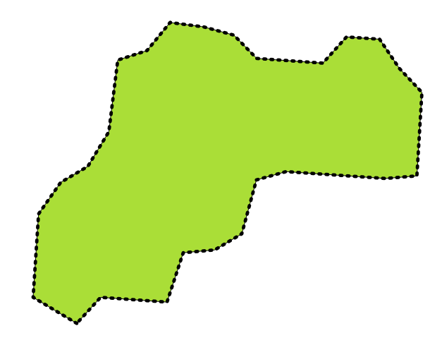
Fig. 24.60 Pradinio poligonų sluoksnio ribos (juodos punktyrinės linijos)
**Linijų geometrijų“ ribos yra jų pabaigos taškai.
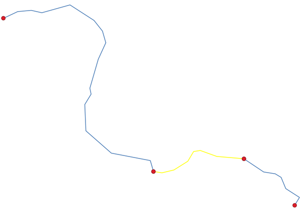
Fig. 24.61 Linijų ribų sluoksnis (raudoni taškai). Geltonas - parinktas geoobjektas.
Parametrai
Užrašas |
Pavadinimas |
Tipas |
Aprašymas |
|---|---|---|---|
Įvesties sluoksnis |
|
[vektorius: linija, poligonas] |
Įvesties linijų ar poligonų vektorinis sluoksnis |
Riba |
|
[vektorius: taškai, linijos] Numatytas: |
Nurodykite išvesties (ribų) sluoksnį. Vienas iš:
Čia taipogi galima pakeisti failo koduotę. |
Išvestys
Užrašas |
Pavadinimas |
Tipas |
Aprašymas |
|---|---|---|---|
Riba |
|
[vektorius: taškai, linijos] |
Įvesties ribų sluoksnis (taškai linijoms, linija poligonams) |
Pythono kodas
Algoritmo ID: native:boundary
import processing
processing.run("algorithm_id", {parameter_dictionary})
algoritmo id rodomas, kai užvedate pelę virš algoritmo apdorojimo įrankinėje. parametrų žodynas teikia parametrų pavadinimus ir reikšmes. Daugiau informacijos apie tai, kaip vykdyti apdorojimo algoritmus Pythono konsolėje rasite skyriuje Using processing algorithms from the console.
24.1.23.5. Apimties stačiakampiai
Skaičiuoja kiekvieno įvesties sluoksnio geoobjekto apimties stačiakampį (voką). Palaikomos poligonų ir linijų geometrijos.
Fig. 24.62 Juodos linijos vaizduoja kiekvieno poligono geoobjekto apimties stačiakampį
Leidžia vietoje keisti poligonų geoobjektus
Taip pat žiūrėkite
Parametrai
Užrašas |
Pavadinimas |
Tipas |
Aprašymas |
|---|---|---|---|
Įvesties sluoksnis |
|
[vektorius: linija, poligonas] |
Įvesties linijų ar poligonų vektorinis sluoksnis |
Aprėptis |
|
[vektorius: poligonas] Numatytas: |
Nurodykite išvesties (apimties stačiakampių) sluoksnį. Vienas iš:
Čia taipogi galima pakeisti failo koduotę. |
Išvestys
Užrašas |
Pavadinimas |
Tipas |
Aprašymas |
|---|---|---|---|
Aprėptis |
|
[vektorius: poligonas] |
Įvesties sluoksnio apimties stačiakampiai. Be įvesties atributų išvesties sluoksnyje taipogi yra šie laukai: sukurto poligono |
Pythono kodas
Algoritmo ID: native:boundingboxes
import processing
processing.run("algorithm_id", {parameter_dictionary})
algoritmo id rodomas, kai užvedate pelę virš algoritmo apdorojimo įrankinėje. parametrų žodynas teikia parametrų pavadinimus ir reikšmes. Daugiau informacijos apie tai, kaip vykdyti apdorojimo algoritmus Pythono konsolėje rasite skyriuje Using processing algorithms from the console.
24.1.23.6. Buferis
Skaičiuoja buferio plotą aplink visus įvesties sluoksnio geoobjektus, naudojant fiksuotą arba nuo duomenų priklausantį atstumą.
Poligono įvesties sluoksniams galima naudoti neigiamą atstumą. Tokiu atveju buferis reikš mažesnį poligoną (sutrauktą).
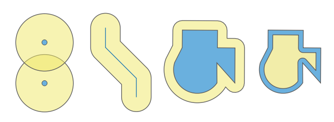
Fig. 24.63 Buferiai (geltoni) taškų, linijų, poligonų su teigiamu buferiu ir poligonas su neigiamu buferiu
Leidžia vietoje keisti poligonų geoobjektus
Numatytas meniu:
Įspėjimas
Šis algoritmas gali išmesti esamus pirminius raktus ar FID reikšmes ir perkurti juos išvesties sluoksniuose, priklausomai nuo to, kokie įvesties parametrai.
Taip pat žiūrėkite
Variable distance buffer, Multi-ring buffer (constant distance), Variable width buffer (by M value)
Parametrai
Baziniai parametrai
Užrašas |
Pavadinimas |
Tipas |
Aprašymas |
|---|---|---|---|
Įvesties sluoksnis |
|
[vektorius: geometrija] |
Įvesties vektorinis sluoksnis |
Atstumas |
|
[skaičius: slankaus kablelio] Numatytas: 10.0 |
Buferio atstumas (nuo kiekvieno geoobjekto ribos). Galite naudoti dešinėje pusėje esantį mygtuką, jei norite nustatyti nuo lauko duomenų priklausantį spindulį skaičiavimui. Tokiu būdu jūs galite skirtingiems geoobjektams turėti skirtingą spindulį. |
Segmentai |
|
[skaičius: sveikas skaičius] Numatytas: 5 |
Valdo skaičių linijų segmentų, kurie naudojami aproksimuojant apskritimo ketvirčius kuriant užapvalintus poslinkius. |
Pabaigos stilius |
|
[sąrašas] Numatytas: 0 |
Nurodo kaip valdomos buferio linijų pabaigos. Vienas iš:
Fig. 24.64 Apvali, plokščia arba kvadratinė pabaiga |
Jungimo stilius |
|
[sąrašas] Numatytas: 0 |
Nurodo, ar paslinkus linijos kampus reikia naudoti apvalias, mitros ar kampines jungtis. Parinktys yra:
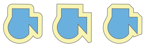
Fig. 24.65 Apvalūs, mitros ir kampo jungimo stiliai |
Mitros riba |
|
[skaičius: slankaus kablelio] Numatyta: 2.0 |
Nustato maksimalų atstumą nuo paslenkamos geometrijos kuriant mitros jungtį. Nurodomas kaip poslinkio atstumo koeficientas (taikoma tik mitros jungimo stiliui). Minimalus: 1.0 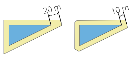
Fig. 24.66 10m buferis su 2 riba ir 10m buferis su 1 riba |
Sulieti rezultatą |
|
[loginis] Numatytas: ne |
Sulieti gautą buferį. Jei 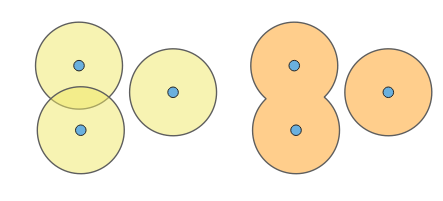
Fig. 24.67 Standartinis (trys vienos dalies geoobjektai - kairėje), sulietas (1 kelių dalių geoobjektas su 2 dalimis - dešinėje) |
Buferiai |
|
[vektorius: poligonas] Numatytas: |
Nurodykite išvesties (buferių) sluoksnį. Vienas iš:
Čia taipogi galima pakeisti failo koduotę. |
Išmanesni parametrai
Užrašas |
Pavadinimas |
Tipas |
Aprašymas |
|---|---|---|---|
Palikti nesusijusius geoobjektus atskirais |
|
[loginis] Numatytas: ne |
Jei 
Fig. 24.68 Rezultatai kaip 2 vienos dalies geoobjektai |
Išvestys
Užrašas |
Pavadinimas |
Tipas |
Aprašymas |
|---|---|---|---|
Buferiai |
|
[vektorius: poligonas] |
Išvesties (buferių) poligonų sluoksnis |
Pythono kodas
Algoritmo ID: native:buffer
import processing
processing.run("algorithm_id", {parameter_dictionary})
algoritmo id rodomas, kai užvedate pelę virš algoritmo apdorojimo įrankinėje. parametrų žodynas teikia parametrų pavadinimus ir reikšmes. Daugiau informacijos apie tai, kaip vykdyti apdorojimo algoritmus Pythono konsolėje rasite skyriuje Using processing algorithms from the console.
24.1.23.7. Centroidai
Sukuria naują taškų sluoksnį su taškais, reprezentuojančiais įvesties sluoksnio geometrijos centroidus.
Centroidas yra vienas taškas, reprezentuojantis geoobjekto (visų dalių) svorio centrą, taigi jis gali būti už geoobjekto ribų. Bet taipogi gali būti ir taškas ant bet kurios geoobjekto dalies.
Išvesties sluoksnio taškų atributai bus tokie patys, kaip pradinių geoobjektų.
Fig. 24.69 Raudonos žvaigždės reprezentuoja įvesties sluoksnio geoobjektų centroidus.
Leidžia taškų geoobjektus keisti vietoje
Numatytas meniu:
Įspėjimas
Šis algoritmas gali išmesti esamus pirminius raktus ar FID reikšmes ir perkurti juos išvesties sluoksniuose, priklausomai nuo to, kokie įvesties parametrai.
Taip pat žiūrėkite
Parametrai
Užrašas |
Pavadinimas |
Tipas |
Aprašymas |
|---|---|---|---|
Įvesties sluoksnis |
|
[vektorius: geometrija] |
Įvesties vektorinis sluoksnis |
Kurti centroidą kiekvienai daliai |
|
[loginis] Numatytas: ne |
Jei True (įjungtas), centroidas bus kuriamas kiekvienai geometrijos daliai |
Centroidai |
|
[vektorius: taškas] Numatytas: |
Nurodykite išvesties (centroidų) sluoksnį. Vienas iš:
Čia taipogi galima pakeisti failo koduotę. |
Išvestys
Užrašas |
Pavadinimas |
Tipas |
Aprašymas |
|---|---|---|---|
Centroidai |
|
[vektorius: taškas] |
Išvesties vektorinis taškų sluoksnis (centroidai) |
Pythono kodas
Algoritmo ID: native:centroids
import processing
processing.run("algorithm_id", {parameter_dictionary})
algoritmo id rodomas, kai užvedate pelę virš algoritmo apdorojimo įrankinėje. parametrų žodynas teikia parametrų pavadinimus ir reikšmes. Daugiau informacijos apie tai, kaip vykdyti apdorojimo algoritmus Pythono konsolėje rasite skyriuje Using processing algorithms from the console.
24.1.23.8. Tikrinti tvarkingumą
Vykdo vektorinio sluoksnio geometrijų tvarkingumo tikrinimą.
Geometrijos klasifikuojamos į tris grupes (tvarkingos, netvarkingos ir klaidos) ir kiekvienai grupei sukuriamas vektorinis sluoksnis su geoobjektais:
Tvarkingos išvesties sluoksnyje yra tik tvarkingi geoobjektai (be topologinių klaidų).
Netvarkingos išvesties sluoksnyje yra visi algoritmo aptikti netvarkingi geoobjektai.
Klaidų išvesties sluoksnyje yra taškai, kur buvo rasti netvarkingi geoobjektai.
Sukurtų sluoksnių atributų lentelėse bus pridėta šiek tiek papildomos informacijos („message“ prie klaidų sluoksnio, „FID“ ir „_errors“ prie netvarkingų sluoksnio ir tik „FID“ prie tvarkingų sluoksnio):
Kiekvieno sukurto vektorinio sluoksnio atributų lentelėje bus šiek tiek papildomos informacijos (rastų klaidų skaičius ir jų tipai):
Fig. 24.70 Kairėje: įvesties sluoksnis. Dešinėje: tinkamų sluoksnis (žalias), netinkamų sluoksnis (oranžinis)
Numatytas meniu:
Taip pat žiūrėkite
Fix geometries ir bazinis priedas Geometry Checker Plugin, Validate coverage
Parametrai
Užrašas |
Pavadinimas |
Tipas |
Aprašymas |
|---|---|---|---|
Įvesties sluoksnis |
|
[vektorius: geometrija] |
Įvesties vektorinis sluoksnis |
Metodas |
|
[sąrašas] Numatyta: 2 |
Tinkamumo tikrinimo metodas. Parinktys:
|
Ignoruoti žiedų susikirtimą |
|
[loginis] Numatytas: ne |
Ignoruoti save kertančius žiedus tikrinant tinkamumą. |
Tvarkingų išvestis |
|
[toks pat, kaip įvestis] Numatytas: |
Nurodykite vektorinį sluoksnį, kuriame bus pradinio sluoksnio tvarkingų geoobjektų kopijos. Vienas iš:
Čia taipogi galima pakeisti failo koduotę. |
Netvarkingų išvestis |
|
[toks pat, kaip įvestis] Numatytas: |
Vektorinis sluoksnis, kuriame bus pradinio sluoksnio netvarkingų geoobjektų kopijos su lauke
Čia taipogi galima pakeisti failo koduotę. |
Klaidų išvestis |
|
[vektorius: taškas] Numatytas: |
Taškų sluoksnis su tiksliomis aptiktų tvarkingumo problemų pozicijomis, lauke
Čia taipogi galima pakeisti failo koduotę. |
Išvestys
Užrašas |
Pavadinimas |
Tipas |
Aprašymas |
|---|---|---|---|
Klaidų skaičius |
|
[skaičius: sveikas skaičius] |
Klaidas sukėlusių geometrijų skaičius. |
Klaidų išvestis |
|
[vektorius: taškas] |
Taškų sluoksnis su tiksliomis aptiktų tinkamumo problemų pozicijomis ir lauke |
Netvarkingų geoobjektų skaičius |
|
[skaičius: sveikas skaičius] |
Netvarkingų geometrijų skaičius. |
Netvarkingų išvestis |
|
[toks pat, kaip įvestis] |
Vektorinis sluoksnis su pradinio sluoksnio netvarkingų geoobjektų kopijomis ir lauke |
Tvarkingų geoobjektų skaičius |
|
[skaičius: sveikas skaičius] |
Tvarkingų geometrijų skaičius. |
Tvarkingų išvestis |
|
[toks pat, kaip įvestis] |
Vektorinis sluoksnis su pradinio sluoksnio tvarkingų geoobjektų kopijomis. |
Pythono kodas
Algoritmo ID: qgis:checkvalidity
import processing
processing.run("algorithm_id", {parameter_dictionary})
algoritmo id rodomas, kai užvedate pelę virš algoritmo apdorojimo įrankinėje. parametrų žodynas teikia parametrų pavadinimus ir reikšmes. Daugiau informacijos apie tai, kaip vykdyti apdorojimo algoritmus Pythono konsolėje rasite skyriuje Using processing algorithms from the console.
Klaidų pranešimų tipai ir jų reikšmės
Geometrijos kontekstas |
GEOS tikrinimas ir klaidos pranešimas |
QGIS tikrinimas ir klaidos pranešimas |
|---|---|---|
Vienas po kito einantys linijos taškai turi tas pačias koordinates 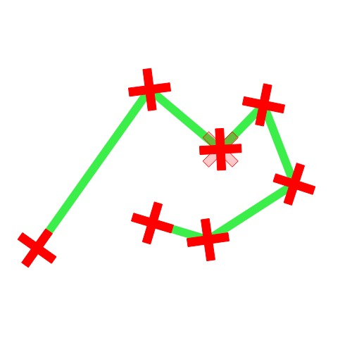
|
|
|
Linijos segmentai kerta vienas kitą 
|
|
|
Poligono geometrija liečia save ir sukuria žiedą 
|
|
|
Du poligono geometrijos žiedai (išorinis ir vidinis) yra identiški 
|
|
|
Geometrija liečia pati save 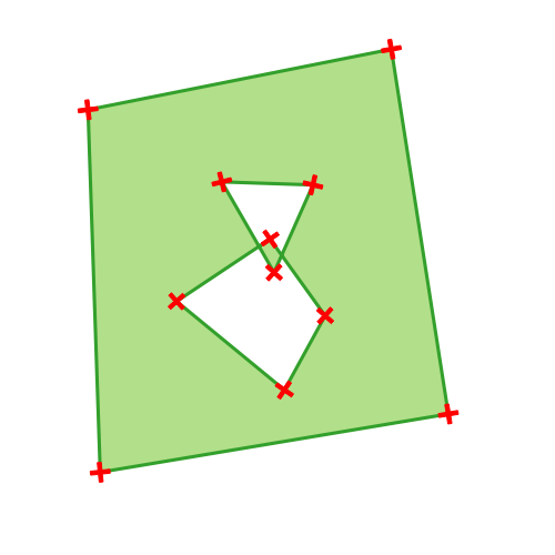
|
|
|
Poligono geometrija yra virš kitos poligono geometrijos 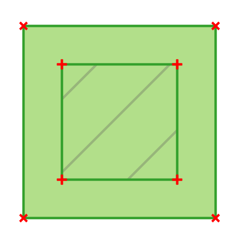
|
|
|
Dalis MultiPoligono geometrijos yra MultiPoligono geometrijos skylėje 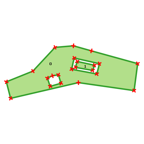
|
|
|
Taško geometrija neturi tinkamos koordinačių poros. Koordinačių poroje nėra platumos reikšmės ir ilgumos reikšmės tokioje rikiuotėje. |
|

24.1.23.9. Collect geometries
Takes a vector layer and collects its geometries into new multipart geometries.
One or more attributes can be specified to collect only geometries belonging to the same class (having the same value for the specified attributes), alternatively all geometries can be collected.
All output geometries will be converted to multi geometries, even those with just a single part. This algorithm does not dissolve overlapping geometries - they will be collected together without modifying the shape of each geometry part.
See the ‚Promote to multipart‘ or ‚Aggregate‘ algorithms for alternative options.
Numatytas meniu:
Įspėjimas
Šis algoritmas išmeta esamus pirminius raktus ar FID reikšmes ir perkuria jas išvesties sluoksniuose.
Taip pat žiūrėkite
Parametrai
Užrašas |
Pavadinimas |
Tipas |
Aprašymas |
|---|---|---|---|
Įvesties sluoksnis |
|
[vektorius: geometrija] |
Įvesties vektorinis sluoksnis |
Unique ID fields |
|
[lentelės laukas: bet koks] [sąrašas] |
Choose one or more attributes to collect the geometries |
Collected |
|
[toks pat, kaip įvestis] |
Vector layer with collected geometries |
Išvestys
Užrašas |
Pavadinimas |
Tipas |
Aprašymas |
|---|---|---|---|
Collected |
|
[toks pat, kaip įvestis] Numatytas: |
Specify the output vector layer for the collected geometries. One of:
Čia taipogi galima pakeisti failo koduotę. |
Pythono kodas
Algorithm ID: native:collect
import processing
processing.run("algorithm_id", {parameter_dictionary})
algoritmo id rodomas, kai užvedate pelę virš algoritmo apdorojimo įrankinėje. parametrų žodynas teikia parametrų pavadinimus ir reikšmes. Daugiau informacijos apie tai, kaip vykdyti apdorojimo algoritmus Pythono konsolėje rasite skyriuje Using processing algorithms from the console.
24.1.23.10. Concave hull
Computes the concave hull of the features from an input point layer.
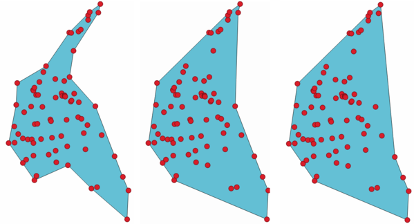
Fig. 24.71 Concave hulls with different thresholds (0.3, 0.6, 0.9)
Taip pat žiūrėkite
Parametrai
Užrašas |
Pavadinimas |
Tipas |
Aprašymas |
|---|---|---|---|
Input point layer |
|
[vektorius: taškas] |
Input point vector layer |
Threshold |
|
[skaičius: slankaus kablelio] Default: 0.3 |
Number from 0 (maximum concave hull) to 1 (convex hull). |
Allow holes |
|
[loginis] Numatytas: Taip |
Choose whether to allow holes in the final concave hull |
Split multipart geometry into singlepart geometries |
|
[loginis] Numatytas: ne |
Check if you want to have singlepart geometries instead of multipart ones. |
Concave hull |
|
[vektorius: poligonas] Numatytas: |
Nurodykite išvesties vektorinį sluoksnį Vienas iš:
Čia taipogi galima pakeisti failo koduotę. |
Išvestys
Užrašas |
Pavadinimas |
Tipas |
Aprašymas |
|---|---|---|---|
Concave hull |
|
[vektorius: poligonas] |
Išvesties vektorinis sluoksnis |
Pythono kodas
Algorithm ID: native:concavehull
import processing
processing.run("algorithm_id", {parameter_dictionary})
algoritmo id rodomas, kai užvedate pelę virš algoritmo apdorojimo įrankinėje. parametrų žodynas teikia parametrų pavadinimus ir reikšmes. Daugiau informacijos apie tai, kaip vykdyti apdorojimo algoritmus Pythono konsolėje rasite skyriuje Using processing algorithms from the console.
24.1.23.11. Convert geometry type
Generates a new layer based on an existing one, with a different type of geometry.
The attribute table of the output layer is the same as the one of the input layer.
Not all conversions are possible. For instance, a line layer can be converted to a point layer, but a point layer cannot be converted to a line layer.
Taip pat žiūrėkite
Polygonize, Lines to polygons, Polygons to lines, Points to path
Parametrai
Užrašas |
Pavadinimas |
Tipas |
Aprašymas |
|---|---|---|---|
Įvesties sluoksnis |
|
[vektorius: geometrija] |
Įvesties vektorinis sluoksnis |
New geometry type |
|
[sąrašas] Numatytas: 0 |
Geometry type to apply to the output features. One of:
|
Pakeistas |
|
[vektorius: geometrija] Numatytas: |
Nurodykite išvesties vektorinį sluoksnį Vienas iš:
Čia taipogi galima pakeisti failo koduotę. |
Išvestys
Užrašas |
Pavadinimas |
Tipas |
Aprašymas |
|---|---|---|---|
Pakeistas |
|
[vektorius: geometrija] |
Output vector layer - the type depends on the parameters |
Pythono kodas
Algorithm ID: qgis:convertgeometrytype
import processing
processing.run("algorithm_id", {parameter_dictionary})
algoritmo id rodomas, kai užvedate pelę virš algoritmo apdorojimo įrankinėje. parametrų žodynas teikia parametrų pavadinimus ir reikšmes. Daugiau informacijos apie tai, kaip vykdyti apdorojimo algoritmus Pythono konsolėje rasite skyriuje Using processing algorithms from the console.
24.1.23.12. Convert to curved geometries
Converts a geometry into its curved geometry equivalent.
Already curved geometries will be retained without change.
Allows
features in-place modification
of line and polygon features
Parametrai
Užrašas |
Pavadinimas |
Tipas |
Aprašymas |
|---|---|---|---|
Įvesties sluoksnis |
|
[vector: line or polygon] |
Įvesties vektorinis sluoksnis |
Maximum distance tolerance |
|
[skaičius: slankaus kablelio] Default: 0.000001 |
The maximum distance allowed between the original location of vertices and where they would fall on the converted curved geometries |
Maximum angle tolerance |
|
[skaičius: slankaus kablelio] Default: 0.000001 |
Segments are considered as suitable for replacing with an arc if the points are all regularly spaced on the candidate arc. This parameter specifies the maximum angular deviation (in degrees) allowed when testing for regular point spacing. Between 0 and 45°. |
Curves |
|
[vector: compoundcurve or curvepolygon] Numatytas: |
Nurodykite išvesties vektorinį sluoksnį Vienas iš:
Čia taipogi galima pakeisti failo koduotę. |
Išvestys
Užrašas |
Pavadinimas |
Tipas |
Aprašymas |
|---|---|---|---|
Curves |
|
[vector: compoundcurve or curvepolygon] |
Output vector layer with curved geometries |
Pythono kodas
Algorithm ID: native:converttocurves
import processing
processing.run("algorithm_id", {parameter_dictionary})
algoritmo id rodomas, kai užvedate pelę virš algoritmo apdorojimo įrankinėje. parametrų žodynas teikia parametrų pavadinimus ir reikšmes. Daugiau informacijos apie tai, kaip vykdyti apdorojimo algoritmus Pythono konsolėje rasite skyriuje Using processing algorithms from the console.
24.1.23.13. Convex hull
Calculates the convex hull for each feature in an input layer.
See the ‚Minimum bounding geometry‘ algorithm for a convex hull calculation which covers the whole layer or grouped subsets of features.
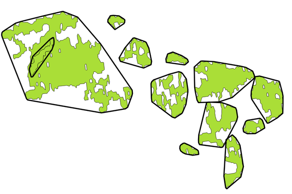
Fig. 24.72 Black lines identify the convex hull for each layer feature
Leidžia vietoje keisti poligonų geoobjektus
Numatytas meniu:
Taip pat žiūrėkite
Parametrai
Užrašas |
Pavadinimas |
Tipas |
Aprašymas |
|---|---|---|---|
Įvesties sluoksnis |
|
[vektorius: geometrija] |
Įvesties vektorinis sluoksnis |
Convex hull |
|
[vektorius: poligonas] Numatytas: |
Nurodykite išvesties vektorinį sluoksnį Vienas iš:
Čia taipogi galima pakeisti failo koduotę. |
Išvestys
Užrašas |
Pavadinimas |
Tipas |
Aprašymas |
|---|---|---|---|
Convex hull |
|
[vektorius: poligonas] |
The output (convex hull) vector layer.
Other than the input attributes, the output layer also contains the following fields:
|
Pythono kodas
Algorithm ID: native:convexhull
import processing
processing.run("algorithm_id", {parameter_dictionary})
algoritmo id rodomas, kai užvedate pelę virš algoritmo apdorojimo įrankinėje. parametrų žodynas teikia parametrų pavadinimus ir reikšmes. Daugiau informacijos apie tai, kaip vykdyti apdorojimo algoritmus Pythono konsolėje rasite skyriuje Using processing algorithms from the console.
24.1.23.14. Create layer from extent
Creates a new vector layer that contains a single feature with geometry matching the extent of the input layer.
It can be used in models to convert a literal extent (xmin,
xmax, ymin, ymax format) into a layer which can be used
for other algorithms which require a layer based input.
Taip pat žiūrėkite
Parametrai
Užrašas |
Pavadinimas |
Tipas |
Aprašymas |
|---|---|---|---|
Apimtis (xmin, xmax, ymin, ymax) |
|
[apimtis] |
Input extent Galimi metodai yra:
|
Apimtis |
|
[vektorius: poligonas] Numatytas: |
Nurodykite išvesties vektorinį sluoksnį Vienas iš:
Čia taipogi galima pakeisti failo koduotę. |
Išvestys
Užrašas |
Pavadinimas |
Tipas |
Aprašymas |
|---|---|---|---|
Apimtis |
|
[vektorius: poligonas] |
The output (extent) vector layer |
Pythono kodas
Algorithm ID: native:extenttolayer
import processing
processing.run("algorithm_id", {parameter_dictionary})
algoritmo id rodomas, kai užvedate pelę virš algoritmo apdorojimo įrankinėje. parametrų žodynas teikia parametrų pavadinimus ir reikšmes. Daugiau informacijos apie tai, kaip vykdyti apdorojimo algoritmus Pythono konsolėje rasite skyriuje Using processing algorithms from the console.
24.1.23.15. Create layer from point
Creates a new vector layer that contains a single feature with geometry matching a point parameter. It can be used in models to convert a point into a point layer for algorithms which require a layer based input.
Taip pat žiūrėkite
Parametrai
Užrašas |
Pavadinimas |
Tipas |
Aprašymas |
|---|---|---|---|
Point |
|
[koordinatės] |
Input point, including CRS info
(example: If the CRS is not provided, the Project CRS will be used. The point can be specified by clicking on the map canvas. |
Point |
|
[vektorius: taškas] Numatytas: |
Nurodykite išvesties sluoksnį. Vienas iš:
Čia taipogi galima pakeisti failo koduotę. |
Išvestys
Užrašas |
Pavadinimas |
Tipas |
Aprašymas |
|---|---|---|---|
Point |
|
[vektorius: taškas] |
The output point vector layer containing the input point. |
Pythono kodas
Algorithm ID: native:pointtolayer
import processing
processing.run("algorithm_id", {parameter_dictionary})
algoritmo id rodomas, kai užvedate pelę virš algoritmo apdorojimo įrankinėje. parametrų žodynas teikia parametrų pavadinimus ir reikšmes. Daugiau informacijos apie tai, kaip vykdyti apdorojimo algoritmus Pythono konsolėje rasite skyriuje Using processing algorithms from the console.
24.1.23.16. Create wedge buffers
Creates wedge shaped buffers from input points.
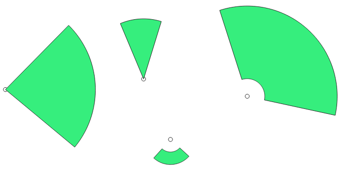
Fig. 24.73 Wedge buffers
The native output from this algorithm are CurvePolygon geometries, but these may be automatically segmentized to Polygons depending on the output format.
Taip pat žiūrėkite
Buferis, Variable width buffer (by M value), Tapered buffers
Parametrai
Užrašas |
Pavadinimas |
Tipas |
Aprašymas |
|---|---|---|---|
Įvesties sluoksnis |
|
[vektorius: taškas] |
Input point vector layer |
Azimuth (degrees from North) |
|
[skaičius: slankaus kablelio] Numatytas: 0.0 |
Angle (in degrees) as the middle value of the wedge |
Wedge width (in degrees) |
|
[skaičius: slankaus kablelio] Default: 45.0 |
Width (in degrees) of the buffer. The wedge will extend to half of the angular width either side of the azimuth direction. 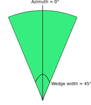
Fig. 24.74 Azimuth and width values of the wedge buffer |
Outer radius |
|
[skaičius: slankaus kablelio] Numatytas: 1.0 |
The outer size (length) of the wedge: the size is meant from the source point to the edge of the wedge shape. |
Inner radius Pasirinktinis |
|
[skaičius: slankaus kablelio] Numatytas: 0.0 |
Inner radius value. If 0 the wedge will begin from the source point. |
Buffers |
|
[vektorius: poligonas] Numatytas: |
Nurodykite išvesties vektorinį sluoksnį Vienas iš:
Čia taipogi galima pakeisti failo koduotę. |
Išvestys
Užrašas |
Pavadinimas |
Tipas |
Aprašymas |
|---|---|---|---|
Buffers |
|
[vektorius: poligonas] |
The output (wedge buffer) vector layer |
Pythono kodas
Algorithm ID: native:wedgebuffers
import processing
processing.run("algorithm_id", {parameter_dictionary})
algoritmo id rodomas, kai užvedate pelę virš algoritmo apdorojimo įrankinėje. parametrų žodynas teikia parametrų pavadinimus ir reikšmes. Daugiau informacijos apie tai, kaip vykdyti apdorojimo algoritmus Pythono konsolėje rasite skyriuje Using processing algorithms from the console.
24.1.23.17. Delaunay triangulation
Creates a polygon layer with the Delaunay triangulation corresponding to the input point layer.
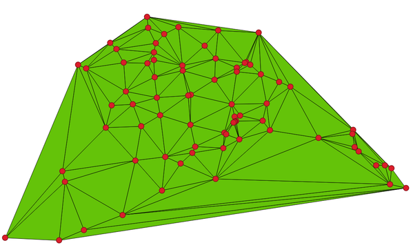
Fig. 24.75 Delaunay triangulation on points
Numatytas meniu:
Parametrai
Užrašas |
Pavadinimas |
Tipas |
Aprašymas |
|---|---|---|---|
Įvesties sluoksnis |
|
[vektorius: taškas] |
Input point vector layer |
Tolerancija Pasirinktinis |
|
[skaičius: slankaus kablelio] Numatytas: 0.0 |
Specifies an optional snapping tolerance which can be used to improve the robustness of the triangulation. |
Add point IDs to output |
|
[loginis] Numatytas: Taip |
Specifies whether fields storing involved point features ID should be added to the output.
If False, an |
Delaunay triangulation |
|
[vektorius: poligonas] Numatytas: |
Nurodykite išvesties vektorinį sluoksnį Vienas iš:
Čia taipogi galima pakeisti failo koduotę. |
Išvestys
Užrašas |
Pavadinimas |
Tipas |
Aprašymas |
|---|---|---|---|
Delaunay triangulation |
|
[vektorius: poligonas] |
The output (Delaunay triangulation) vector layer |
Pythono kodas
Algorithm ID: native:delaunaytriangulation
import processing
processing.run("algorithm_id", {parameter_dictionary})
algoritmo id rodomas, kai užvedate pelę virš algoritmo apdorojimo įrankinėje. parametrų žodynas teikia parametrų pavadinimus ir reikšmes. Daugiau informacijos apie tai, kaip vykdyti apdorojimo algoritmus Pythono konsolėje rasite skyriuje Using processing algorithms from the console.
24.1.23.18. Delete holes
Takes a polygon layer and removes holes in polygons. It creates a new vector layer in which polygons with holes have been replaced by polygons with only their external ring. Attributes are not modified.
An optional minimum area parameter allows removing only holes which
are smaller than a specified area threshold. Leaving this parameter at
0.0 results in all holes being removed.
Fig. 24.76 Before and after the cleaning
Leidžia vietoje keisti poligonų geoobjektus
Parametrai
Užrašas |
Pavadinimas |
Tipas |
Aprašymas |
|---|---|---|---|
Įvesties sluoksnis |
|
[vektorius: poligonas] |
Įvesties poligonų vektorinis sluoksnis |
Remove holes with area less than Pasirinktinis |
|
[skaičius: slankaus kablelio] Numatytas: 0.0 |
Only holes with an area less than this threshold will be
deleted.
With a value of |
Cleaned |
|
[toks pat, kaip įvestis] Numatytas: |
Nurodykite išvesties vektorinį sluoksnį Vienas iš:
Čia taipogi galima pakeisti failo koduotę. |
Išvestys
Užrašas |
Pavadinimas |
Tipas |
Aprašymas |
|---|---|---|---|
Cleaned |
|
[toks pat, kaip įvestis] |
The output (cleaned) vector layer |
Pythono kodas
Algorithm ID: native:deleteholes
import processing
processing.run("algorithm_id", {parameter_dictionary})
algoritmo id rodomas, kai užvedate pelę virš algoritmo apdorojimo įrankinėje. parametrų žodynas teikia parametrų pavadinimus ir reikšmes. Daugiau informacijos apie tai, kaip vykdyti apdorojimo algoritmus Pythono konsolėje rasite skyriuje Using processing algorithms from the console.
24.1.23.19. Densify by count
Takes a polygon or line layer and generates a new one in which the geometries have a larger number of vertices than the original one.
If the geometries have Z or M values present then these will be linearly interpolated at the added vertices.
The number of new vertices to add to each segment is specified as an input parameter.
Fig. 24.77 Red points show the vertices before and after the densify
Allows
features in-place modification
of line and polygon features
Numatytas meniu:
Taip pat žiūrėkite
Parametrai
Užrašas |
Pavadinimas |
Tipas |
Aprašymas |
|---|---|---|---|
Įvesties sluoksnis |
|
[vektorius: linija, poligonas] |
Įvesties linijų ar poligonų vektorinis sluoksnis |
Vertices to add |
|
[skaičius: sveikas skaičius] Numatytas: 1 |
Number of vertices to add to each segment |
Densified |
|
[toks pat, kaip įvestis] Numatytas: |
Nurodykite išvesties vektorinį sluoksnį Vienas iš:
Čia taipogi galima pakeisti failo koduotę. |
Išvestys
Užrašas |
Pavadinimas |
Tipas |
Aprašymas |
|---|---|---|---|
Densified |
|
[toks pat, kaip įvestis] |
The output (densified) vector layer |
Pythono kodas
Algorithm ID: native:densifygeometries
import processing
processing.run("algorithm_id", {parameter_dictionary})
algoritmo id rodomas, kai užvedate pelę virš algoritmo apdorojimo įrankinėje. parametrų žodynas teikia parametrų pavadinimus ir reikšmes. Daugiau informacijos apie tai, kaip vykdyti apdorojimo algoritmus Pythono konsolėje rasite skyriuje Using processing algorithms from the console.
24.1.23.20. Densify by interval
Takes a polygon or line layer and generates a new one in which the geometries have a larger number of vertices than the original one.
The geometries are densified by adding regularly placed extra vertices inside each segment so that the maximum distance between any two vertices does not exceed the specified distance.
If the geometries have Z or M values present then these will be linearly interpolated at the added vertices.
Pavyzdys
Specifying a distance of 3 would cause the segment
[0 0] -> [10 0] to be converted to
[0 0] -> [2.5 0] -> [5 0] -> [7.5 0] -> [10 0],
since 3 extra vertices are required on the segment and spacing these
at 2.5 increments allows them to be evenly spaced over the segment.
Fig. 24.78 Densify geometry at a given interval
Allows
features in-place modification
of line and polygon features
Taip pat žiūrėkite
Parametrai
Užrašas |
Pavadinimas |
Tipas |
Aprašymas |
|---|---|---|---|
Įvesties sluoksnis |
|
[vektorius: linija, poligonas] |
Įvesties linijų ar poligonų vektorinis sluoksnis |
Interval between vertices to add |
|
[skaičius: slankaus kablelio] Numatytas: 1.0 |
Maximum distance between two consecutive vertices |
Densified |
|
[toks pat, kaip įvestis] Numatytas: |
Nurodykite išvesties vektorinį sluoksnį Vienas iš:
Čia taipogi galima pakeisti failo koduotę. |
Išvestys
Užrašas |
Pavadinimas |
Tipas |
Aprašymas |
|---|---|---|---|
Densified |
|
[toks pat, kaip įvestis] |
The output (densified) vector layer |
Pythono kodas
Algorithm ID: native:densifygeometriesgivenaninterval
import processing
processing.run("algorithm_id", {parameter_dictionary})
algoritmo id rodomas, kai užvedate pelę virš algoritmo apdorojimo įrankinėje. parametrų žodynas teikia parametrų pavadinimus ir reikšmes. Daugiau informacijos apie tai, kaip vykdyti apdorojimo algoritmus Pythono konsolėje rasite skyriuje Using processing algorithms from the console.
24.1.23.21. Dissolve
Takes a vector layer and combines its features into new features. One or more attributes can be specified to dissolve features belonging to the same class (having the same value for the specified attributes), alternatively all features can be dissolved to a single feature.
All output geometries will be converted to multi geometries. In case the input is a polygon layer, common boundaries of adjacent polygons being dissolved will get erased. If enabled, the optional „Keep disjoint features separate“ setting will cause features and parts that do not overlap or touch to be exported as separate features (instead of parts of a single multipart feature).
The resulting attribute table will have the same fields as the input layer. The values in the output layer’s fields are the ones of the first input feature that happens to be processed.
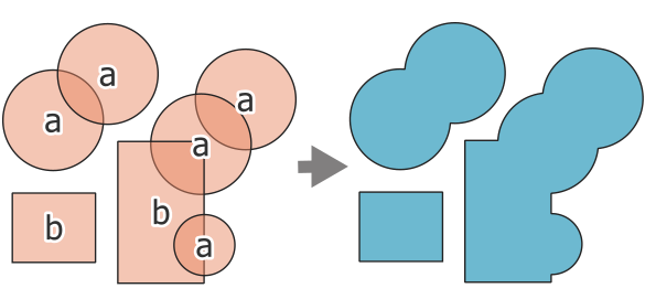
Fig. 24.79 Dissolving a layer into a single multipart feature
Numatytas meniu:
Įspėjimas
Šis algoritmas išmeta esamus pirminius raktus ar FID reikšmes ir perkuria jas išvesties sluoksniuose.
Taip pat žiūrėkite
Parametrai
Baziniai parametrai
Užrašas |
Pavadinimas |
Tipas |
Aprašymas |
|---|---|---|---|
Įvesties sluoksnis |
|
[vektorius: geometrija] |
Įvesties vektorinis sluoksnis |
Dissolve field(s) Pasirinktinis |
|
[lentelės laukas: bet koks] [sąrašas] Default: [] |
Features having the same value for the selected field(s) will be replaced with a single one and their geometries are merged. If no field is provided then all the features are dissolved, resulting in a single (multipart) feature. 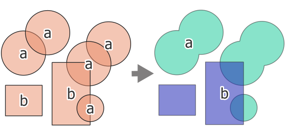
Fig. 24.80 Dissolve the polygon layer on a common attribute (2 multipart features) |
Sulietas |
|
[toks pat, kaip įvestis] Numatytas: |
Nurodykite išvesties vektorinį sluoksnį Vienas iš:
Čia taipogi galima pakeisti failo koduotę. |
Išmanesni parametrai
Užrašas |
Pavadinimas |
Tipas |
Aprašymas |
|---|---|---|---|
Palikti nesusijusius geoobjektus atskirais |
|
[loginis] Numatytas: ne |
Parts of dissolved features are exported as separate features (instead of parts of a multipart feature). 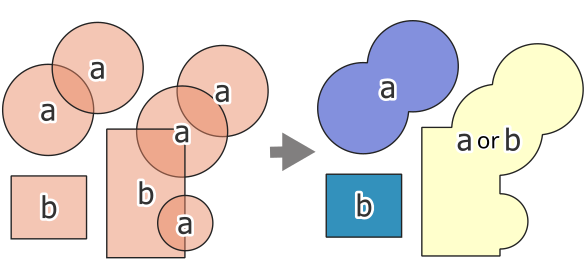
Fig. 24.81 source (left), dissolve all (3 distinct features - right) 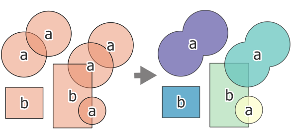
Fig. 24.82 source (left), dissolve on field (5 distinct features - right) |
Išvestys
Užrašas |
Pavadinimas |
Tipas |
Aprašymas |
|---|---|---|---|
Sulietas |
|
[toks pat, kaip įvestis] |
The output vector layer with dissolved geometries |
Pythono kodas
Algorithm ID: native:dissolve
import processing
processing.run("algorithm_id", {parameter_dictionary})
algoritmo id rodomas, kai užvedate pelę virš algoritmo apdorojimo įrankinėje. parametrų žodynas teikia parametrų pavadinimus ir reikšmes. Daugiau informacijos apie tai, kaip vykdyti apdorojimo algoritmus Pythono konsolėje rasite skyriuje Using processing algorithms from the console.
24.1.23.22. Drape (set Z value from raster)
Uses values sampled from a band within a raster layer to set the Z value for every overlapping vertex in the feature geometry. The raster values can optionally be scaled by a preset amount.
If Z values already exist in the layer, they will be overwritten with the new value. If no Z values exist, the geometry will be upgraded to include the Z dimension.
Allows
features in-place modification
of point, line, and polygon features with Z enabled
Taip pat žiūrėkite
Parametrai
Užrašas |
Pavadinimas |
Tipas |
Aprašymas |
|---|---|---|---|
Įvesties sluoksnis |
|
[vektorius: geometrija] |
Įvesties vektorinis sluoksnis |
Rastro sluoksnis |
|
[rastras] |
Raster layer with Z values |
Juostos numeris |
|
[rastro juosta] Numatytas: 1 |
The raster band to take the Z values from |
Value for NoData or non-intersecting vertices |
|
[skaičius: slankaus kablelio] Numatytas: 0.0 |
Value to use in case the vertex does not intersect (a valid pixel of) the raster |
Scale factor |
|
[skaičius: slankaus kablelio] Numatytas: 1.0 |
Scaling value: the band values are multiplied by this value. |
Offset |
|
[skaičius: slankaus kablelio] Numatytas: 0.0 |
Offset value: it is algebraically added to the band values after applying the „Scale factor“. |
Updated |
|
[toks pat, kaip įvestis] Numatytas: |
Specify the output vector layer (with Z values from the raster layer). One of:
Čia taipogi galima pakeisti failo koduotę. |
Išvestys
Užrašas |
Pavadinimas |
Tipas |
Aprašymas |
|---|---|---|---|
Updated |
|
[toks pat, kaip įvestis] |
The output vector layer with Z values from the raster layer |
Pythono kodas
Algorithm ID: native:setzfromraster
import processing
processing.run("algorithm_id", {parameter_dictionary})
algoritmo id rodomas, kai užvedate pelę virš algoritmo apdorojimo įrankinėje. parametrų žodynas teikia parametrų pavadinimus ir reikšmes. Daugiau informacijos apie tai, kaip vykdyti apdorojimo algoritmus Pythono konsolėje rasite skyriuje Using processing algorithms from the console.
24.1.23.23. Drop M/Z values
Removes M (measure) or Z (altitude) values from input geometries.
Taip pat žiūrėkite
Parametrai
Užrašas |
Pavadinimas |
Tipas |
Aprašymas |
|---|---|---|---|
Įvesties sluoksnis |
|
[vektorius: geometrija] |
Input vector layer with M or Z values |
Drop M Values |
|
[loginis] Numatytas: ne |
Removes the M values from the geometries |
Drop Z Values |
|
[loginis] Numatytas: ne |
Removes the Z values from the geometries |
Z/M Dropped |
|
[toks pat, kaip įvestis] Numatytas: |
Nurodykite išvesties vektorinį sluoksnį Vienas iš:
Čia taipogi galima pakeisti failo koduotę. |
Išvestys
Užrašas |
Pavadinimas |
Tipas |
Aprašymas |
|---|---|---|---|
Z/M Dropped |
|
[toks pat, kaip įvestis] |
The output vector layer (identical to the input layer, except that the M and/or Z dimensions have been removed from the geometries). |
Pythono kodas
Algorithm ID: native:dropmzvalues
import processing
processing.run("algorithm_id", {parameter_dictionary})
algoritmo id rodomas, kai užvedate pelę virš algoritmo apdorojimo įrankinėje. parametrų žodynas teikia parametrų pavadinimus ir reikšmes. Daugiau informacijos apie tai, kaip vykdyti apdorojimo algoritmus Pythono konsolėje rasite skyriuje Using processing algorithms from the console.
24.1.23.24. Eliminate selected polygons
Combines selected polygons of the input layer with certain adjacent polygons by erasing their common boundary. The adjacent polygon can be either the one with the largest or smallest area or the one sharing the largest common boundary with the polygon to be eliminated.
Eliminate is normally used to get rid of sliver polygons, i.e. tiny polygons that are a result of polygon intersection processes where boundaries of the inputs are similar but not identical.
Numatytas meniu:
Taip pat žiūrėkite
Parametrai
Užrašas |
Pavadinimas |
Tipas |
Aprašymas |
|---|---|---|---|
Įvesties sluoksnis |
|
[vektorius: poligonas] |
Įvesties poligonų vektorinis sluoksnis |
Merge selection with the neighboring polygon with the |
|
[sąrašas] Numatytas: jokio |
Choose the parameter to use in order to get rid of the selected polygons:
|
Eliminated |
|
[vektorius: poligonas] Numatytas: |
Nurodykite išvesties vektorinį sluoksnį Vienas iš:
Čia taipogi galima pakeisti failo koduotę. |
Išvestys
Užrašas |
Pavadinimas |
Tipas |
Aprašymas |
|---|---|---|---|
Eliminated |
|
[vektorius: poligonas] |
The output polygon vector layer. |
Pythono kodas
Algorithm ID: qgis:eliminateselectedpolygons
import processing
processing.run("algorithm_id", {parameter_dictionary})
algoritmo id rodomas, kai užvedate pelę virš algoritmo apdorojimo įrankinėje. parametrų žodynas teikia parametrų pavadinimus ir reikšmes. Daugiau informacijos apie tai, kaip vykdyti apdorojimo algoritmus Pythono konsolėje rasite skyriuje Using processing algorithms from the console.
24.1.23.25. Explode lines
Takes a lines layer and creates a new one in which each line layer is replaced by a set of lines representing the segments in the original line.
Each line in the resulting layer contains only a start and an end point, with no intermediate vertices between them.
If the input layer consists of CircularStrings or CompoundCurves, the output layer will be of the same type and contain only single curve segments.
Pastaba
Šis algoritmas išmeta esamus pirminius raktus ar FID reikšmes ir perkuria jas išvesties sluoksniuose.
This algorithm does not require valid geometries as input.
Fig. 24.83 The original line layer and the exploded one
Leidžia linijų geoobjektus keisti vietoje
Taip pat žiūrėkite
Parametrai
Užrašas |
Pavadinimas |
Tipas |
Aprašymas |
|---|---|---|---|
Įvesties sluoksnis |
|
[vektorius: linija] |
Įvesties vektorinis linijų sluoksnis |
Exploded |
|
[vektorius: linija] Numatytas: |
Nurodykite išvesties vektorinį sluoksnį Vienas iš:
Čia taipogi galima pakeisti failo koduotę. |
Išvestys
Užrašas |
Pavadinimas |
Tipas |
Aprašymas |
|---|---|---|---|
Exploded |
|
[vektorius: linija] |
The output line vector layer with features representing each segment of the input layer. |
Pythono kodas
Algorithm ID: native:explodelines
import processing
processing.run("algorithm_id", {parameter_dictionary})
algoritmo id rodomas, kai užvedate pelę virš algoritmo apdorojimo įrankinėje. parametrų žodynas teikia parametrų pavadinimus ir reikšmes. Daugiau informacijos apie tai, kaip vykdyti apdorojimo algoritmus Pythono konsolėje rasite skyriuje Using processing algorithms from the console.
24.1.23.26. Extend lines
Extends line geometry by a specified amount at the start and end of the line.
Lines are extended using the bearing of the first and last segment in the line.
Fig. 24.84 The red dashes represent the initial and final extension of the original layer
Leidžia linijų geoobjektus keisti vietoje
Taip pat žiūrėkite
Parametrai
Užrašas |
Pavadinimas |
Tipas |
Aprašymas |
|---|---|---|---|
Įvesties sluoksnis |
|
[vektorius: linija] |
Įvesties vektorinis linijų sluoksnis |
Start distance |
|
[skaičius: slankaus kablelio] Numatytas: 0.0 |
Distance by which to extend the first segment of the line (starting point) |
End distance |
|
[skaičius: slankaus kablelio] Numatytas: 0.0 |
Distance by which to extend the last segment of the line (ending point) |
Extended |
|
[vektorius: linija] Numatytas: |
Nurodykite išvesties vektorinį sluoksnį Vienas iš:
Čia taipogi galima pakeisti failo koduotę. |
Išvestys
Užrašas |
Pavadinimas |
Tipas |
Aprašymas |
|---|---|---|---|
Extended |
|
[vektorius: linija] |
The output (extended) line vector layer. |
Pythono kodas
Algorithm ID: native:extendlines
import processing
processing.run("algorithm_id", {parameter_dictionary})
algoritmo id rodomas, kai užvedate pelę virš algoritmo apdorojimo įrankinėje. parametrų žodynas teikia parametrų pavadinimus ir reikšmes. Daugiau informacijos apie tai, kaip vykdyti apdorojimo algoritmus Pythono konsolėje rasite skyriuje Using processing algorithms from the console.
24.1.23.27. Extract M values
Extracts M values from geometries into feature attributes.
By default only the M value from the first vertex of each feature is extracted, however the algorithm can optionally calculate statistics on all of the geometry’s M values, including sum, mean, minimum and maximum.
Taip pat žiūrėkite
Parametrai
Užrašas |
Pavadinimas |
Tipas |
Aprašymas |
|---|---|---|---|
Įvesties sluoksnis |
|
[vektorius: geometrija] |
Įvesties vektorinis sluoksnis |
Summaries to calculate |
|
[sąrašas] Numatytas: [0] |
Statistics on the M values of a geometry. One or more of:
|
Output column prefix |
|
[tekstas] Default: ‚m_‘ |
The prefix for the output (M) column |
Extracted |
|
[toks pat, kaip įvestis] Numatytas: |
Nurodykite išvesties sluoksnį. Vienas iš:
Čia taipogi galima pakeisti failo koduotę. |
Išvestys
Užrašas |
Pavadinimas |
Tipas |
Aprašymas |
|---|---|---|---|
Extracted |
|
[toks pat, kaip įvestis] |
The output vector layer (with M values) |
Pythono kodas
Algorithm ID: native:extractmvalues
import processing
processing.run("algorithm_id", {parameter_dictionary})
algoritmo id rodomas, kai užvedate pelę virš algoritmo apdorojimo įrankinėje. parametrų žodynas teikia parametrų pavadinimus ir reikšmes. Daugiau informacijos apie tai, kaip vykdyti apdorojimo algoritmus Pythono konsolėje rasite skyriuje Using processing algorithms from the console.
24.1.23.28. Extract specific vertices
Takes a vector layer and generates a point layer with points representing specific vertices in the input geometries.
For instance, this algorithm can be used to extract the first or last vertices in the geometry. The attributes associated to each point are the same ones associated to the feature that the vertex belongs to.
The vertex indices parameter accepts a comma separated string specifying the indices of the vertices to extract. The first vertex corresponds to an index of 0, the second vertex has an index of 1, etc. Negative indices can be used to find vertices at the end of the geometry, e.g., an index of -1 corresponds to the last vertex, -2 corresponds to the second last vertex, etc.
Additional fields are added to the vertices indicating the specific vertex position (e.g., 0, -1, etc), the original vertex index, the vertex’s part and its index within the part (as well as its ring for polygons), distance along the original geometry and bisector angle of vertex for the original geometry.
Leidžia taškų geoobjektus keisti vietoje
Įspėjimas
Šis algoritmas išmeta esamus pirminius raktus ar FID reikšmes ir perkuria jas išvesties sluoksniuose.
Taip pat žiūrėkite
Extract vertices, Filter vertices by M value, Filter vertices by Z value
Parametrai
Užrašas |
Pavadinimas |
Tipas |
Aprašymas |
|---|---|---|---|
Įvesties sluoksnis |
|
[vektorius: geometrija] |
Įvesties vektorinis sluoksnis |
Vertex indices |
|
[tekstas] Default: ‚0‘ |
Comma-separated string of the indices of the vertices to extract. |
Vertices |
|
[vektorius: taškas] Numatytas: |
Nurodykite išvesties vektorinį sluoksnį Vienas iš:
Čia taipogi galima pakeisti failo koduotę. |
Išvestys
Užrašas |
Pavadinimas |
Tipas |
Aprašymas |
|---|---|---|---|
Vertices |
|
[vektorius: taškas] |
The output (point) vector layer containing the specified vertices from the input layer geometries. Other than the input attributes, the output layer also contains the following fields:
|
Pythono kodas
Algorithm ID: native:extractspecificvertices
import processing
processing.run("algorithm_id", {parameter_dictionary})
algoritmo id rodomas, kai užvedate pelę virš algoritmo apdorojimo įrankinėje. parametrų žodynas teikia parametrų pavadinimus ir reikšmes. Daugiau informacijos apie tai, kaip vykdyti apdorojimo algoritmus Pythono konsolėje rasite skyriuje Using processing algorithms from the console.
24.1.23.29. Extract vertices
Takes a vector layer and generates a point layer with points representing the vertices in the input geometries.
The attributes associated to each point are the same ones associated to the feature that the vertex belongs to.
Additional fields are added to the vertices indicating the vertex index (beginning at 0), the feature’s part and its index within the part (as well as its ring for polygons), distance along original geometry and bisector angle of vertex for original geometry.
Fig. 24.85 Vertices extracted for line and polygon layer
Leidžia taškų geoobjektus keisti vietoje
Numatytas meniu:
Įspėjimas
Šis algoritmas išmeta esamus pirminius raktus ar FID reikšmes ir perkuria jas išvesties sluoksniuose.
Taip pat žiūrėkite
Extract specific vertices, Filter vertices by M value, Filter vertices by Z value
Parametrai
Užrašas |
Pavadinimas |
Tipas |
Aprašymas |
|---|---|---|---|
Įvesties sluoksnis |
|
[vektorius: geometrija] |
Įvesties vektorinis sluoksnis |
Vertices |
|
[vektorius: taškas] Numatytas: |
Nurodykite išvesties vektorinį sluoksnį Vienas iš:
Čia taipogi galima pakeisti failo koduotę. |
Išvestys
Užrašas |
Pavadinimas |
Tipas |
Aprašymas |
|---|---|---|---|
Vertices |
|
[vektorius: taškas] |
The output (point) vector layer containing the vertices from the input layer geometries. Other than the input attributes, the output layer also contains the following fields:
|
Pythono kodas
Algorithm ID: native:extractvertices
import processing
processing.run("algorithm_id", {parameter_dictionary})
algoritmo id rodomas, kai užvedate pelę virš algoritmo apdorojimo įrankinėje. parametrų žodynas teikia parametrų pavadinimus ir reikšmes. Daugiau informacijos apie tai, kaip vykdyti apdorojimo algoritmus Pythono konsolėje rasite skyriuje Using processing algorithms from the console.
24.1.23.30. Extract Z values
Extracts Z values from geometries into feature attributes.
By default only the Z value from the first vertex of each feature is extracted, however the algorithm can optionally calculate statistics on all of the geometry’s Z values, including sum, mean, minimum and maximum.
Taip pat žiūrėkite
Parametrai
Užrašas |
Pavadinimas |
Tipas |
Aprašymas |
|---|---|---|---|
Įvesties sluoksnis |
|
[vektorius: geometrija] |
Įvesties vektorinis sluoksnis |
Summaries to calculate |
|
[sąrašas] Numatytas: [0] |
Statistics on the Z values of a geometry. One or more of:
|
Output column prefix |
|
[tekstas] Default: ‚z_‘ |
The prefix for the output (Z) column |
Extracted |
|
[toks pat, kaip įvestis] Numatytas: |
Nurodykite išvesties sluoksnį. Vienas iš:
Čia taipogi galima pakeisti failo koduotę. |
Išvestys
Užrašas |
Pavadinimas |
Tipas |
Aprašymas |
|---|---|---|---|
Extracted |
|
[toks pat, kaip įvestis] |
The output vector layer (with Z values) |
Pythono kodas
Algorithm ID: native:extractzvalues
import processing
processing.run("algorithm_id", {parameter_dictionary})
algoritmo id rodomas, kai užvedate pelę virš algoritmo apdorojimo įrankinėje. parametrų žodynas teikia parametrų pavadinimus ir reikšmes. Daugiau informacijos apie tai, kaip vykdyti apdorojimo algoritmus Pythono konsolėje rasite skyriuje Using processing algorithms from the console.
24.1.23.31. Filter vertices by M value
Filters away vertices based on their M value, returning geometries with only vertex points that have a M value greater than or equal to the specified minimum value and/or less than or equal to the maximum value.
If the minimum value is not specified then only the maximum value is tested, and similarly if the maximum value is not specified then only the minimum value is tested.
Fig. 24.86 The red line represents the black line with only vertices whose M value is <=10.
Allows
features in-place modification
of point, line and polygon features with M enabled
Įspėjimas
Depending on the input geometry attributes and the filters used, the geometries created by this algorithm may no longer be valid.
Taip pat žiūrėkite
Filter vertices by Z value, Extract vertices, Extract specific vertices
Parametrai
Užrašas |
Pavadinimas |
Tipas |
Aprašymas |
|---|---|---|---|
Įvesties sluoksnis |
|
[vektorius: geometrija] |
Input vector layer to remove vertices from |
Minimum Pasirinktinis |
|
[skaičius: slankaus kablelio] Numatytas: jokio |
Minimum of M values allowed |
Maximum Pasirinktinis |
|
[skaičius: slankaus kablelio] Numatytas: jokio |
Maximum of M values allowed |
Filtered |
|
[toks pat, kaip įvestis] Numatytas: |
Nurodykite išvesties vektorinį sluoksnį Vienas iš:
Čia taipogi galima pakeisti failo koduotę. |
Išvestys
Užrašas |
Pavadinimas |
Tipas |
Aprašymas |
|---|---|---|---|
Filtered |
|
[toks pat, kaip įvestis] |
The output vector layer of features with only the filtered vertices. |
Pythono kodas
Algorithm ID: native:filterverticesbym
import processing
processing.run("algorithm_id", {parameter_dictionary})
algoritmo id rodomas, kai užvedate pelę virš algoritmo apdorojimo įrankinėje. parametrų žodynas teikia parametrų pavadinimus ir reikšmes. Daugiau informacijos apie tai, kaip vykdyti apdorojimo algoritmus Pythono konsolėje rasite skyriuje Using processing algorithms from the console.
24.1.23.32. Filter vertices by Z value
Filters away vertices based on their Z value, returning geometries with only vertex points that have a Z value greater than or equal to the specified minimum value and/or less than or equal to the maximum value.
If the minimum value is not specified then only the maximum value is tested, and similarly if the maximum value is not specified then only the minimum value is tested.
Fig. 24.87 The red line represents the black line with only vertices whose Z value is <=10.
Allows
features in-place modification
of point, line and polygon features with Z enabled
Įspėjimas
Depending on the input geometry attributes and the filters used, the geometries created by this algorithm may no longer be valid. You may need to run the Fix geometries algorithm to ensure their validity.
Taip pat žiūrėkite
Filter vertices by M value, Extract vertices, Extract specific vertices
Parametrai
Užrašas |
Pavadinimas |
Tipas |
Aprašymas |
|---|---|---|---|
Įvesties sluoksnis |
|
[vektorius: geometrija] |
Input vector layer to remove vertices from |
Minimum Pasirinktinis |
|
[skaičius: slankaus kablelio] Numatytas: jokio |
Minimum of Z values allowed |
Maximum Pasirinktinis |
|
[skaičius: slankaus kablelio] Numatytas: jokio |
Maximum of Z values allowed |
Filtered |
|
[toks pat, kaip įvestis] Numatytas: |
Nurodykite išvesties vektorinį sluoksnį Vienas iš:
Čia taipogi galima pakeisti failo koduotę. |
Išvestys
Užrašas |
Pavadinimas |
Tipas |
Aprašymas |
|---|---|---|---|
Filtered |
|
[toks pat, kaip įvestis] |
The output vector layer of features with only the filtered vertices. |
Pythono kodas
Algorithm ID: native:filterverticesbyz
import processing
processing.run("algorithm_id", {parameter_dictionary})
algoritmo id rodomas, kai užvedate pelę virš algoritmo apdorojimo įrankinėje. parametrų žodynas teikia parametrų pavadinimus ir reikšmes. Daugiau informacijos apie tai, kaip vykdyti apdorojimo algoritmus Pythono konsolėje rasite skyriuje Using processing algorithms from the console.
24.1.23.33. Fix geometries
Attempts to create a valid representation of a given invalid geometry without losing any of the input vertices. Already valid geometries are returned without further intervention. Always outputs multi-geometry layer.
Allows
features in-place modification
of point, line, and polygon features without M enabled
Įspėjimas
M values will be dropped from the output.
Taip pat žiūrėkite
Parametrai
Užrašas |
Pavadinimas |
Tipas |
Aprašymas |
|---|---|---|---|
Įvesties sluoksnis |
|
[vektorius: geometrija] |
Įvesties vektorinis sluoksnis |
Repair method |
|
[sąrašas] Numatytas: 1 |
Method used to repair the geometries. One of:
|
Fixed geometries |
|
[toks pat, kaip įvestis] Numatytas: |
Nurodykite išvesties vektorinį sluoksnį Vienas iš:
Čia taipogi galima pakeisti failo koduotę. |
Išvestys
Užrašas |
Pavadinimas |
Tipas |
Aprašymas |
|---|---|---|---|
Fixed geometries |
|
[toks pat, kaip įvestis] |
The output vector layer with fixed geometries. |
Pythono kodas
Algorithm ID: native:fixgeometries
import processing
processing.run("algorithm_id", {parameter_dictionary})
algoritmo id rodomas, kai užvedate pelę virš algoritmo apdorojimo įrankinėje. parametrų žodynas teikia parametrų pavadinimus ir reikšmes. Daugiau informacijos apie tai, kaip vykdyti apdorojimo algoritmus Pythono konsolėje rasite skyriuje Using processing algorithms from the console.
24.1.23.34. Force right-hand-rule
Forces polygon geometries to respect the Right-Hand-Rule, in which the area that is bounded by a polygon is to the right of the boundary. In particular, the exterior ring is oriented in a clockwise direction and any interior rings in a counter-clockwise direction.
Leidžia vietoje keisti poligonų geoobjektus
Parametrai
Užrašas |
Pavadinimas |
Tipas |
Aprašymas |
|---|---|---|---|
Įvesties sluoksnis |
|
[vektorius: poligonas] |
Įvesties vektorinis sluoksnis |
Reoriented |
|
[vektorius: poligonas] Numatytas: |
Nurodykite išvesties vektorinį sluoksnį Vienas iš:
Čia taipogi galima pakeisti failo koduotę. |
Išvestys
Užrašas |
Pavadinimas |
Tipas |
Aprašymas |
|---|---|---|---|
Reoriented |
|
[vektorius: poligonas] |
The output vector layer with reoriented geometries. |
Pythono kodas
Algorithm ID: native:forcerhr
import processing
processing.run("algorithm_id", {parameter_dictionary})
algoritmo id rodomas, kai užvedate pelę virš algoritmo apdorojimo įrankinėje. parametrų žodynas teikia parametrų pavadinimus ir reikšmes. Daugiau informacijos apie tai, kaip vykdyti apdorojimo algoritmus Pythono konsolėje rasite skyriuje Using processing algorithms from the console.
24.1.23.35. Geodesic line split at antimeridian
Splits a line into multiple geodesic segments, whenever the line crosses the antimeridian (±180 degrees longitude).
Splitting at the antimeridian helps the visual display of the lines in some projections. The returned geometry will always be a multi-part geometry.
Whenever line segments in the input geometry cross the antimeridian, they will be split into two segments, with the latitude of the breakpoint being determined using a geodesic line connecting the points either side of this segment. The current project ellipsoid setting will be used when calculating this breakpoint.
If the input geometry contains M or Z values, these will be linearly interpolated for the new vertices created at the antimeridian.
Pastaba
Šis algoritmas naudoja elipse paremtus skaičiavimus ir atsižvelgia į dabartinius elipsoido nustatymus.
Leidžia linijų geoobjektus keisti vietoje
Parametrai
Užrašas |
Pavadinimas |
Tipas |
Aprašymas |
|---|---|---|---|
Įvesties sluoksnis |
|
[vektorius: linija] |
Įvesties vektorinis linijų sluoksnis |
Split |
|
[vektorius: linija] Numatytas: |
Specify the output line vector layer. One of:
Čia taipogi galima pakeisti failo koduotę. |
Išvestys
Užrašas |
Pavadinimas |
Tipas |
Aprašymas |
|---|---|---|---|
Split |
|
[vektorius: linija] |
The output line vector layer split at the antimeridian. |
Pythono kodas
Algorithm ID: native:antimeridiansplit
import processing
processing.run("algorithm_id", {parameter_dictionary})
algoritmo id rodomas, kai užvedate pelę virš algoritmo apdorojimo įrankinėje. parametrų žodynas teikia parametrų pavadinimus ir reikšmes. Daugiau informacijos apie tai, kaip vykdyti apdorojimo algoritmus Pythono konsolėje rasite skyriuje Using processing algorithms from the console.
24.1.23.36. Geometry by expression
Updates existing geometries (or creates new geometries) for input features by use of a QGIS expression.
This allows complex geometry modifications which can utilize all the flexibility of the QGIS expression engine to manipulate and create geometries for output features.
For help with QGIS expression functions, see the inbuilt help available in the expression builder.
Parametrai
Užrašas |
Pavadinimas |
Tipas |
Aprašymas |
|---|---|---|---|
Įvesties sluoksnis |
|
[vektorius: bet koks] |
Įvesties vektorinis sluoksnis |
Output geometry type |
|
[sąrašas] Numatytas: 0 |
The output geometry strongly depends on the expression: for instance, if you create a buffer the geometry type has to be polygon. One of:
|
Output geometry has z values |
|
[loginis] Numatytas: ne |
Choose if the output geometry should include the Z dimension |
Output geometry has m values |
|
[loginis] Numatytas: ne |
Choose if the output geometry should include the M dimension |
Geometry expression |
|
[išraiška] Default: ‚$geometry‘ |
Add the geometry expression you want to use. You can use the button to open the Expression Dialog. The dialog lists all the relevant expressions, together with their help and guide. |
Modified geometry |
|
[vektorius: geometrija] Numatytas: |
Nurodykite išvesties vektorinį sluoksnį Vienas iš:
Čia taipogi galima pakeisti failo koduotę. |
Išvestys
Užrašas |
Pavadinimas |
Tipas |
Aprašymas |
|---|---|---|---|
Modified geometry |
|
[vektorius: geometrija] |
Išvesties vektorinis sluoksnis |
Pythono kodas
Algorithm ID: native:geometrybyexpression
import processing
processing.run("algorithm_id", {parameter_dictionary})
algoritmo id rodomas, kai užvedate pelę virš algoritmo apdorojimo įrankinėje. parametrų žodynas teikia parametrų pavadinimus ir reikšmes. Daugiau informacijos apie tai, kaip vykdyti apdorojimo algoritmus Pythono konsolėje rasite skyriuje Using processing algorithms from the console.
24.1.23.37. Interpolate point on line
Creates a point geometry interpolated at a set distance along line or curve geometries.
Z and M values are linearly interpolated from existing values.
If a multipart geometry is encountered, only the first part is considered when calculating the substring.
If the specified distance is greater than the input feature’s length, the resultant feature will have a null geometry.
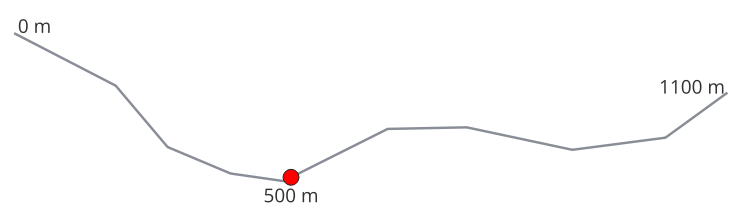
Fig. 24.88 Interpolated point at 500m of the beginning of the line
Taip pat žiūrėkite
Parametrai
Užrašas |
Pavadinimas |
Tipas |
Aprašymas |
|---|---|---|---|
Įvesties sluoksnis |
|
[vektorius: linija, poligonas] |
Įvesties linijų ar poligonų vektorinis sluoksnis |
Atstumas |
|
[skaičius: slankaus kablelio] Numatytas: 0.0 |
Distance from the beginning of the line |
Interpolated points |
|
[vektorius: taškas] Numatytas: |
Nurodykite išvesties vektorinį sluoksnį Vienas iš:
Čia taipogi galima pakeisti failo koduotę. |
Išvestys
Užrašas |
Pavadinimas |
Tipas |
Aprašymas |
|---|---|---|---|
Interpolated points |
|
[vektorius: taškas] |
The output point vector layer with features at a set distance along the line or polygon boundary |
Pythono kodas
Algorithm ID: native:interpolatepoint
import processing
processing.run("algorithm_id", {parameter_dictionary})
algoritmo id rodomas, kai užvedate pelę virš algoritmo apdorojimo įrankinėje. parametrų žodynas teikia parametrų pavadinimus ir reikšmes. Daugiau informacijos apie tai, kaip vykdyti apdorojimo algoritmus Pythono konsolėje rasite skyriuje Using processing algorithms from the console.
24.1.23.38. Keep N biggest parts
Takes a layer with polygons or multipolygons and returns a new layer in which only the n largest polygons of each multipolygon feature are kept. If a feature has n or fewer parts, the feature will just be copied.
Fig. 24.89 Clockwise from top left: original multipart feature, one, two and three biggest parts kept
Parametrai
Užrašas |
Pavadinimas |
Tipas |
Aprašymas |
|---|---|---|---|
Poligonai |
|
[vektorius: poligonas] |
Įvesties poligonų vektorinis sluoksnis |
Parts to keep |
|
[skaičius: sveikas skaičius] Numatytas: 1 |
Number of parts to keep. If 1, only the biggest part of the feature will be kept. |
Parts |
|
[vektorius: poligonas] Numatytas: |
Specify the output polygon vector layer. One of:
Čia taipogi galima pakeisti failo koduotę. |
Išvestys
Užrašas |
Pavadinimas |
Tipas |
Aprašymas |
|---|---|---|---|
Parts |
|
[vektorius: poligonas] |
The output polygon vector layer with the N biggest parts of each feature |
Pythono kodas
Algorithm ID: qgis:keepnbiggestparts
import processing
processing.run("algorithm_id", {parameter_dictionary})
algoritmo id rodomas, kai užvedate pelę virš algoritmo apdorojimo įrankinėje. parametrų žodynas teikia parametrų pavadinimus ir reikšmes. Daugiau informacijos apie tai, kaip vykdyti apdorojimo algoritmus Pythono konsolėje rasite skyriuje Using processing algorithms from the console.
24.1.23.39. Line substring
Returns the portion of a line (or curve) which falls between the specified start and end distances (measured from the beginning of the line).
Z and M values are linearly interpolated from existing values.
If a multipart geometry is encountered, only the first part is considered when calculating the substring.
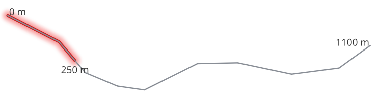
Fig. 24.90 Substring line with starting distance set at 0 meters and the ending distance at 250 meters.
Leidžia linijų geoobjektus keisti vietoje
Taip pat žiūrėkite
Parametrai
Užrašas |
Pavadinimas |
Tipas |
Aprašymas |
|---|---|---|---|
Įvesties sluoksnis |
|
[vektorius: linija] |
Įvesties vektorinis linijų sluoksnis |
Start distance |
|
[skaičius: slankaus kablelio] Numatytas: 0.0 |
Distance along the input line to the start point of the output feature |
End distance |
|
[skaičius: slankaus kablelio] Numatytas: 1.0 |
Distance along the input line to the end point of the output feature |
Substring |
|
[vektorius: linija] Numatytas: |
Specify the output line vector layer. One of:
Čia taipogi galima pakeisti failo koduotę. |
Išvestys
Užrašas |
Pavadinimas |
Tipas |
Aprašymas |
|---|---|---|---|
Substring |
|
[vektorius: linija] |
The output line vector layer. |
Pythono kodas
Algorithm ID: native:linesubstring
import processing
processing.run("algorithm_id", {parameter_dictionary})
algoritmo id rodomas, kai užvedate pelę virš algoritmo apdorojimo įrankinėje. parametrų žodynas teikia parametrų pavadinimus ir reikšmes. Daugiau informacijos apie tai, kaip vykdyti apdorojimo algoritmus Pythono konsolėje rasite skyriuje Using processing algorithms from the console.
24.1.23.40. Lines to polygons
Generates a polygon layer using as polygon rings the lines from an input line layer.
The attribute table of the output layer is the same as the one of the input layer.
Numatytas meniu:
Taip pat žiūrėkite
Parametrai
Užrašas |
Pavadinimas |
Tipas |
Aprašymas |
|---|---|---|---|
Įvesties sluoksnis |
|
[vektorius: linija] |
Įvesties vektorinis linijų sluoksnis |
Poligonai |
|
[vektorius: poligonas] Numatytas: |
Specify the output polygon vector layer. One of:
Čia taipogi galima pakeisti failo koduotę. |
Išvestys
Užrašas |
Pavadinimas |
Tipas |
Aprašymas |
|---|---|---|---|
Poligonai |
|
[vektorius: poligonas] |
The output polygon vector layer. |
Pythono kodas
Algorithm ID: qgis:linestopolygons
import processing
processing.run("algorithm_id", {parameter_dictionary})
algoritmo id rodomas, kai užvedate pelę virš algoritmo apdorojimo įrankinėje. parametrų žodynas teikia parametrų pavadinimus ir reikšmes. Daugiau informacijos apie tai, kaip vykdyti apdorojimo algoritmus Pythono konsolėje rasite skyriuje Using processing algorithms from the console.
24.1.23.41. Merge lines
Joins all connected parts of MultiLineString geometries into single LineString geometries.
If any parts of the input MultiLineString geometries are not connected, the resultant geometry will be a MultiLineString containing any lines which could be merged and any non-connected line parts.
Leidžia linijų geoobjektus keisti vietoje
Parametrai
Užrašas |
Pavadinimas |
Tipas |
Aprašymas |
|---|---|---|---|
Įvesties sluoksnis |
|
[vektorius: linija] |
Įvesties vektorinis linijų sluoksnis |
Sulietas |
|
[vektorius: linija] Numatytas: |
Specify the output line vector layer. One of:
Čia taipogi galima pakeisti failo koduotę. |
Išvestys
Užrašas |
Pavadinimas |
Tipas |
Aprašymas |
|---|---|---|---|
Sulietas |
|
[vektorius: linija] |
The output (merged) line vector layer. |
Pythono kodas
Algorithm ID: native:mergelines
import processing
processing.run("algorithm_id", {parameter_dictionary})
algoritmo id rodomas, kai užvedate pelę virš algoritmo apdorojimo įrankinėje. parametrų žodynas teikia parametrų pavadinimus ir reikšmes. Daugiau informacijos apie tai, kaip vykdyti apdorojimo algoritmus Pythono konsolėje rasite skyriuje Using processing algorithms from the console.
24.1.23.42. Minimum bounding geometry
Creates geometries which enclose the features from an input layer. The features can be grouped by a field. The output layer will then contain one feature per group value with a geometry (MBB) that covers the geometries of the features with matching value.
The following enclosing geometry types are supported:
bounding box (envelope)
oriented rectangle
circle
convex hull
Fig. 24.91 Clockwise from top left: envelope, oriented rectangle, circle, convex hull
Taip pat žiūrėkite
Parametrai
Užrašas |
Pavadinimas |
Tipas |
Aprašymas |
|---|---|---|---|
Įvesties sluoksnis |
|
[vektorius: geometrija] |
Įvesties vektorinis sluoksnis |
Field Pasirinktinis |
|
[lentelės laukas: bet koks] |
Features can be grouped by a field. If set, this causes the output layer to contain one feature per grouped value with a minimal geometry covering only the features with matching values. |
Geometry type |
|
[sąrašas] Numatytas: 0 |
Enclosing geometry types. One of:
|
Bounding geometry |
|
[vektorius: poligonas] Numatytas: |
Specify the output polygon vector layer. One of:
Čia taipogi galima pakeisti failo koduotę. |
Išvestys
Užrašas |
Pavadinimas |
Tipas |
Aprašymas |
|---|---|---|---|
Bounding geometry |
|
[vektorius: poligonas] |
The output (bounding) polygon vector layer.
It has the fields from the input layer
and, depending on the selected parameter
|
Pythono kodas
Algorithm ID: qgis:minimumboundinggeometry
import processing
processing.run("algorithm_id", {parameter_dictionary})
algoritmo id rodomas, kai užvedate pelę virš algoritmo apdorojimo įrankinėje. parametrų žodynas teikia parametrų pavadinimus ir reikšmes. Daugiau informacijos apie tai, kaip vykdyti apdorojimo algoritmus Pythono konsolėje rasite skyriuje Using processing algorithms from the console.
24.1.23.43. Minimum enclosing circles
Calculates the minimum enclosing circles of the features in the input layer.
Fig. 24.92 Enclosing circles for each feature
Leidžia vietoje keisti poligonų geoobjektus
Taip pat žiūrėkite
Parametrai
Užrašas |
Pavadinimas |
Tipas |
Aprašymas |
|---|---|---|---|
Įvesties sluoksnis |
|
[vektorius: geometrija] |
Įvesties vektorinis sluoksnis |
Number of segments in circles |
|
[skaičius: sveikas skaičius] Default: 72 |
The number of segments used to approximate a circle. Minimum 8, maximum 100000. |
Minimum enclosing circles |
|
[vektorius: poligonas] Numatytas: |
Specify the output polygon vector layer. One of:
Čia taipogi galima pakeisti failo koduotę. |
Išvestys
Užrašas |
Pavadinimas |
Tipas |
Aprašymas |
|---|---|---|---|
Minimum enclosing circles |
|
[vektorius: poligonas] |
The output polygon vector layer.
Other than the input attributes, the output layer also contains the following fields:
|
Pythono kodas
Algorithm ID: native:minimumenclosingcircle
import processing
processing.run("algorithm_id", {parameter_dictionary})
algoritmo id rodomas, kai užvedate pelę virš algoritmo apdorojimo įrankinėje. parametrų žodynas teikia parametrų pavadinimus ir reikšmes. Daugiau informacijos apie tai, kaip vykdyti apdorojimo algoritmus Pythono konsolėje rasite skyriuje Using processing algorithms from the console.
24.1.23.44. Multi-ring buffer (constant distance)
Computes multi-ring (donut) buffer for the features of the input layer, using a fixed or dynamic distance and number of rings.
Fig. 24.93 Multi-ring buffer for a line, point and polygon layer
Leidžia vietoje keisti poligonų geoobjektus
Įspėjimas
Šis algoritmas išmeta esamus pirminius raktus ar FID reikšmes ir perkuria jas išvesties sluoksniuose.
Taip pat žiūrėkite
Buferis, Variable distance buffer, Rectangles, ovals, diamonds, Single sided buffer
Parametrai
Užrašas |
Pavadinimas |
Tipas |
Aprašymas |
|---|---|---|---|
Įvesties sluoksnis |
|
[vektorius: geometrija] |
Įvesties vektorinis sluoksnis |
Number of rings |
|
[skaičius: sveikas skaičius] Numatytas: 1 |
The number of rings. It can be a unique value (same number of rings for all the features) or it can be taken from features data (the number of rings depends on feature values). |
Distance between rings |
|
[skaičius: slankaus kablelio] Numatytas: 1.0 |
Distance between the rings. It can be a unique value (same distance for all the features) or it can be taken from features data (the distance depends on feature values). |
Multi-ring buffer (constant distance) |
|
[vektorius: poligonas] Numatytas: |
Specify the output polygon vector layer. One of:
Čia taipogi galima pakeisti failo koduotę. |
Išvestys
Užrašas |
Pavadinimas |
Tipas |
Aprašymas |
|---|---|---|---|
Multi-ring buffer (constant distance) |
|
[vektorius: poligonas] |
The output polygon vector layer.
Other than the input attributes, the output layer also contains the following fields:
|
Pythono kodas
Algorithm ID: native:multiringconstantbuffer
import processing
processing.run("algorithm_id", {parameter_dictionary})
algoritmo id rodomas, kai užvedate pelę virš algoritmo apdorojimo įrankinėje. parametrų žodynas teikia parametrų pavadinimus ir reikšmes. Daugiau informacijos apie tai, kaip vykdyti apdorojimo algoritmus Pythono konsolėje rasite skyriuje Using processing algorithms from the console.
24.1.23.45. Multipart to singleparts
Splits multipart features in the input layer into singlepart features.
The attributes of the output layer are the same as the original ones but divided into single features.
Fig. 24.94 Left the multipart source layer and right the single part output result
Leidžia taškų, linijų ir poligonų geoobjektus keisti vietoje
Numatytas meniu:
Įspėjimas
Šis algoritmas išmeta esamus pirminius raktus ar FID reikšmes ir perkuria jas išvesties sluoksniuose.
Taip pat žiūrėkite
Parametrai
Užrašas |
Pavadinimas |
Tipas |
Aprašymas |
|---|---|---|---|
Įvesties sluoksnis |
|
[vektorius: geometrija] |
Įvesties vektorinis sluoksnis |
Single parts |
|
[toks pat, kaip įvestis] Numatytas: |
Specify the output polygon vector layer. One of:
Čia taipogi galima pakeisti failo koduotę. |
Išvestys
Užrašas |
Pavadinimas |
Tipas |
Aprašymas |
|---|---|---|---|
Single parts |
|
[toks pat, kaip įvestis] |
The output vector layer. |
Pythono kodas
Algorithm ID: native:multiparttosingleparts
import processing
processing.run("algorithm_id", {parameter_dictionary})
algoritmo id rodomas, kai užvedate pelę virš algoritmo apdorojimo įrankinėje. parametrų žodynas teikia parametrų pavadinimus ir reikšmes. Daugiau informacijos apie tai, kaip vykdyti apdorojimo algoritmus Pythono konsolėje rasite skyriuje Using processing algorithms from the console.
24.1.23.46. Offset lines
Offsets lines by a specified distance. Positive distances will offset lines to the left, and negative distances will offset them to the right.
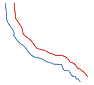
Fig. 24.95 Mėlynas - pradinis sluoksnis, raudonas - paslinktasis
Leidžia linijų geoobjektus keisti vietoje
Taip pat žiūrėkite
Parametrai
Užrašas |
Pavadinimas |
Tipas |
Aprašymas |
|---|---|---|---|
Įvesties sluoksnis |
|
[vektorius: linija] |
Įvesties vektorinis linijų sluoksnis |
Atstumas |
|
[skaičius: slankaus kablelio] Numatytas: 10.0 |
Offset distance. You can use the Data Defined button on the right to choose a field from which the radius will be calculated. This way you can have different radius for each feature (see Variable distance buffer). |
Segmentai |
|
[skaičius: sveikas skaičius] Numatyta: 8 |
Valdo skaičių linijų segmentų, kurie naudojami aproksimuojant apskritimo ketvirčius kuriant užapvalintus poslinkius. |
Jungimo stilius |
|
[sąrašas] Numatytas: 0 |
Nurodo, ar paslinkus linijos kampus reikia naudoti apvalias, mitros ar kampines jungtis. Parinktys yra:
Fig. 24.96 Apvalūs, mitros ir kampo jungimo stiliai |
Mitros riba |
|
[skaičius: slankaus kablelio] Numatyta: 2.0 |
Nustato maksimalų atstumą nuo paslenkamos geometrijos kuriant mitros jungtį. Nurodomas kaip poslinkio atstumo koeficientas (taikoma tik mitros jungimo stiliui). Minimalus: 1.0
Fig. 24.97 10m buferis su 2 riba ir 10m buferis su 1 riba |
Offset |
|
[vektorius: linija] Numatytas: |
Specify the output (offset) layer. One of:
Čia taipogi galima pakeisti failo koduotę. |
Išvestys
Užrašas |
Pavadinimas |
Tipas |
Aprašymas |
|---|---|---|---|
Offset |
|
[vektorius: linija] |
Output (offset) line layer |
Pythono kodas
Algorithm ID: native:offsetline
import processing
processing.run("algorithm_id", {parameter_dictionary})
algoritmo id rodomas, kai užvedate pelę virš algoritmo apdorojimo įrankinėje. parametrų žodynas teikia parametrų pavadinimus ir reikšmes. Daugiau informacijos apie tai, kaip vykdyti apdorojimo algoritmus Pythono konsolėje rasite skyriuje Using processing algorithms from the console.
24.1.23.47. Oriented minimum bounding box
Calculates the minimum area rotated rectangle for each feature in the input layer.
Fig. 24.98 Oriented minimum bounding box
Leidžia vietoje keisti poligonų geoobjektus
Taip pat žiūrėkite
Parametrai
Užrašas |
Pavadinimas |
Tipas |
Aprašymas |
|---|---|---|---|
Įvesties sluoksnis |
|
[vektorius: geometrija] |
Įvesties vektorinis sluoksnis |
Bounding boxes |
|
[vektorius: poligonas] Numatytas: |
Specify the output polygon vector layer. One of:
Čia taipogi galima pakeisti failo koduotę. |
Išvestys
Užrašas |
Pavadinimas |
Tipas |
Aprašymas |
|---|---|---|---|
Bounding boxes |
|
[vektorius: poligonas] |
The output polygon vector layer.
Other than the input attributes, the output layer also contains the following fields:
|
Pythono kodas
Algorithm ID: native:orientedminimumboundingbox
import processing
processing.run("algorithm_id", {parameter_dictionary})
algoritmo id rodomas, kai užvedate pelę virš algoritmo apdorojimo įrankinėje. parametrų žodynas teikia parametrų pavadinimus ir reikšmes. Daugiau informacijos apie tai, kaip vykdyti apdorojimo algoritmus Pythono konsolėje rasite skyriuje Using processing algorithms from the console.
24.1.23.48. Orthogonalize
Attempts to orthogonalize the geometries of the input line or polygon layer. This process shifts the vertices in the geometries to try to make every angle in the geometry either a right angle or a straight line.
Fig. 24.99 In blue the source layer and in the red orthogonalized result
Allows
features in-place modification
of line and polygon features
Parametrai
Užrašas |
Pavadinimas |
Tipas |
Aprašymas |
|---|---|---|---|
Įvesties sluoksnis |
|
[vektorius: linija, poligonas] |
Įvesties linijų ar poligonų vektorinis sluoksnis |
Maximum angle tolerance (degrees) |
|
[skaičius: slankaus kablelio] Default: 15.0 |
Specify the maximum deviation from a right angle or straight line a vertex can have for it to be adjusted. Smaller tolerances mean that only vertices which are already closer to right angles will be adjusted, and larger tolerances mean that vertices which deviate further from right angles will also be adjusted. |
Maximum algorithm iterations |
|
[skaičius: sveikas skaičius] Numatytas: 1000 |
Setting a larger number for the maximum number of iterations will result in a more orthogonal geometry at the cost of extra processing time. |
Orthogonalized |
|
[toks pat, kaip įvestis] Numatytas: |
Specify the output polygon vector layer. One of:
Čia taipogi galima pakeisti failo koduotę. |
Išvestys
Užrašas |
Pavadinimas |
Tipas |
Aprašymas |
|---|---|---|---|
Orthogonalized |
|
[toks pat, kaip įvestis] |
The output polygon vector layer with adjusted angles. |
Pythono kodas
Algorithm ID: native:orthogonalize
import processing
processing.run("algorithm_id", {parameter_dictionary})
algoritmo id rodomas, kai užvedate pelę virš algoritmo apdorojimo įrankinėje. parametrų žodynas teikia parametrų pavadinimus ir reikšmes. Daugiau informacijos apie tai, kaip vykdyti apdorojimo algoritmus Pythono konsolėje rasite skyriuje Using processing algorithms from the console.
24.1.23.49. Point on Surface
For each feature of the input layer, returns a point that is guaranteed to lie on the surface of the feature geometry.
Leidžia taškų geoobjektus keisti vietoje
Įspėjimas
Šis algoritmas gali išmesti esamus pirminius raktus ar FID reikšmes ir perkurti juos išvesties sluoksniuose, priklausomai nuo to, kokie įvesties parametrai.
Taip pat žiūrėkite
Parametrai
Užrašas |
Pavadinimas |
Tipas |
Aprašymas |
|---|---|---|---|
Įvesties sluoksnis |
|
[vektorius: geometrija] |
Įvesties vektorinis sluoksnis |
Create point on surface for each part |
|
[loginis] |
If checked, a point will be created for each part of the geometry. |
Point |
|
[vektorius: taškas] Numatytas: |
Specify the output point vector layer. One of:
Čia taipogi galima pakeisti failo koduotę. |
Išvestys
Užrašas |
Pavadinimas |
Tipas |
Aprašymas |
|---|---|---|---|
Point |
|
[vektorius: taškas] |
The output point vector layer. |
Pythono kodas
Algorithm ID: native:pointonsurface
import processing
processing.run("algorithm_id", {parameter_dictionary})
algoritmo id rodomas, kai užvedate pelę virš algoritmo apdorojimo įrankinėje. parametrų žodynas teikia parametrų pavadinimus ir reikšmes. Daugiau informacijos apie tai, kaip vykdyti apdorojimo algoritmus Pythono konsolėje rasite skyriuje Using processing algorithms from the console.
24.1.23.50. Points along geometry
Creates points at regular intervals along line or polygon geometries. Created points will have new attributes added for the distance along the geometry and the angle of the line at the point.
An optional start and end offset can be specified, which controls how far from the start and end of the geometry the points should be created.
Fig. 24.100 Points created along the source line layer
Įspėjimas
Šis algoritmas išmeta esamus pirminius raktus ar FID reikšmes ir perkuria jas išvesties sluoksniuose.
Taip pat žiūrėkite
Parametrai
Užrašas |
Pavadinimas |
Tipas |
Aprašymas |
|---|---|---|---|
Įvesties sluoksnis |
|
[vektorius: linija, poligonas] |
Įvesties linijų ar poligonų vektorinis sluoksnis |
Atstumas |
|
[skaičius: slankaus kablelio] Numatytas: 1.0 |
Distance between two consecutive points along the line |
Start offset |
|
[skaičius: slankaus kablelio] Numatytas: 0.0 |
Distance from the beginning of the input line, representing the position of the first point. |
End offset |
|
[skaičius: slankaus kablelio] Numatytas: 0.0 |
Distance from the end of the input line, representing the position beyond which no point feature shoud be created. |
Interpolated points |
|
[vektorius: taškas] Numatytas: |
Nurodykite išvesties vektorinį sluoksnį Vienas iš:
Čia taipogi galima pakeisti failo koduotę. |
Išvestys
Užrašas |
Pavadinimas |
Tipas |
Aprašymas |
|---|---|---|---|
Interpolated points |
|
[vektorius: taškas] |
Point vector layer with features placed along lines or polygon
boundaries of the input layer.
Other than the input attributes on every related point, the output layer
also contains the following fields:
|
Pythono kodas
Algorithm ID: native:pointsalonglines
import processing
processing.run("algorithm_id", {parameter_dictionary})
algoritmo id rodomas, kai užvedate pelę virš algoritmo apdorojimo įrankinėje. parametrų žodynas teikia parametrų pavadinimus ir reikšmes. Daugiau informacijos apie tai, kaip vykdyti apdorojimo algoritmus Pythono konsolėje rasite skyriuje Using processing algorithms from the console.
24.1.23.51. Points displacement
Given a distance of proximity, identifies nearby point features and radially distributes them over a circle whose center represents their barycenter. A convenient tool to scatter overlaid features.
Parametrai
Užrašas |
Pavadinimas |
Tipas |
Aprašymas |
|---|---|---|---|
Įvesties sluoksnis |
|
[vektorius: taškas] |
Input point vector layer |
Minimum distance to other points |
|
[skaičius: slankaus kablelio] Numatytas: 1.0 |
Distance below which point features are considered close. Close features are distributed altogether. |
Displacement distance |
|
[skaičius: slankaus kablelio] Numatytas: 1.0 |
Radius of the circle on which close features are placed |
Horizontal distribution for two point case |
|
[loginis] Numatytas: ne |
When only two points are identified as close, aligns them horizontally on the circle instead of vertically. |
Displaced |
|
[vektorius: taškas] Numatytas: |
Nurodykite išvesties vektorinį sluoksnį Vienas iš:
Čia taipogi galima pakeisti failo koduotę. |
Išvestys
Užrašas |
Pavadinimas |
Tipas |
Aprašymas |
|---|---|---|---|
Displaced |
|
[vektorius: taškas] |
Output point vector layer |
Pythono kodas
Algorithm ID: qgis:pointsdisplacement
import processing
processing.run("algorithm_id", {parameter_dictionary})
algoritmo id rodomas, kai užvedate pelę virš algoritmo apdorojimo įrankinėje. parametrų žodynas teikia parametrų pavadinimus ir reikšmes. Daugiau informacijos apie tai, kaip vykdyti apdorojimo algoritmus Pythono konsolėje rasite skyriuje Using processing algorithms from the console.
24.1.23.52. Pole of inaccessibility
Calculates the pole of inaccessibility for a polygon layer, which is the most distant internal point from the boundary of the surface.
This algorithm uses the ‚polylabel‘ algorithm (Vladimir Agafonkin, 2016), which is an iterative approach guaranteed to find the true pole of inaccessibility within a specified tolerance. A more precise tolerance (lower value) requires more iterations and will take longer to calculate.
Fig. 24.101 Pole of inaccessibility
Parametrai
Užrašas |
Pavadinimas |
Tipas |
Aprašymas |
|---|---|---|---|
Įvesties sluoksnis |
|
[vektorius: poligonas] |
Įvesties vektorinis sluoksnis |
Tolerancija |
|
[skaičius: slankaus kablelio] Numatytas: 1.0 |
Set the tolerance for the calculation |
Point |
|
[vektorius: taškas] Numatytas: |
Specify the output polygon vector layer. One of:
Čia taipogi galima pakeisti failo koduotę. |
Išvestys
Užrašas |
Pavadinimas |
Tipas |
Aprašymas |
|---|---|---|---|
Point |
|
[vektorius: taškas] |
The output point vector layer.
It will contain a new attribute with the distance |
Pythono kodas
Algorithm ID: native:poleofinaccessibility
import processing
processing.run("algorithm_id", {parameter_dictionary})
algoritmo id rodomas, kai užvedate pelę virš algoritmo apdorojimo įrankinėje. parametrų žodynas teikia parametrų pavadinimus ir reikšmes. Daugiau informacijos apie tai, kaip vykdyti apdorojimo algoritmus Pythono konsolėje rasite skyriuje Using processing algorithms from the console.
24.1.23.53. Polygonize
Creates a polygon layer whose features boundaries are generated from a line layer of closed features.
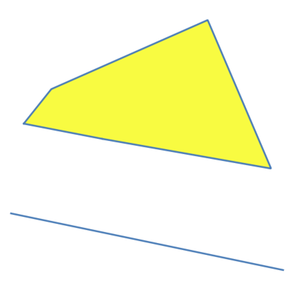
Fig. 24.102 The yellow polygons generated from the closed lines
Pastaba
The line layer must have closed shapes in order to be transformed into a polygon.
Taip pat žiūrėkite
Parametrai
Užrašas |
Pavadinimas |
Tipas |
Aprašymas |
|---|---|---|---|
Įvesties sluoksnis |
|
[vektorius: linija] |
Įvesties vektorinis linijų sluoksnis |
Keep fields from the input layer |
|
[loginis] Numatytas: ne |
Check to keep the fields (only the table structure, not the values) of the input layer |
Polygons from lines |
|
[vektorius: poligonas] Numatytas: |
Specify the output polygon vector layer. One of:
Čia taipogi galima pakeisti failo koduotę. |
Išvestys
Užrašas |
Pavadinimas |
Tipas |
Aprašymas |
|---|---|---|---|
Polygons from lines |
|
[vektorius: poligonas] |
The output polygon vector layer from lines |
Pythono kodas
Algorithm ID: native:polygonize
import processing
processing.run("algorithm_id", {parameter_dictionary})
algoritmo id rodomas, kai užvedate pelę virš algoritmo apdorojimo įrankinėje. parametrų žodynas teikia parametrų pavadinimus ir reikšmes. Daugiau informacijos apie tai, kaip vykdyti apdorojimo algoritmus Pythono konsolėje rasite skyriuje Using processing algorithms from the console.
24.1.23.54. Polygons to lines
Takes a polygon layer and creates a line layer, with lines representing the boundaries of the polygons in the input layer.
The attribute table of the output layer is the same as the one of the input layer.
Fig. 24.103 Black lines as the result of the algorithm
Numatytas meniu:
Taip pat žiūrėkite
Parametrai
Užrašas |
Pavadinimas |
Tipas |
Aprašymas |
|---|---|---|---|
Įvesties sluoksnis |
|
[vektorius: poligonas] |
Įvesties poligonų vektorinis sluoksnis |
Lines |
|
[vektorius: linija] Numatytas: |
Specify the output line vector layer. One of:
Čia taipogi galima pakeisti failo koduotę. |
Išvestys
Užrašas |
Pavadinimas |
Tipas |
Aprašymas |
|---|---|---|---|
Lines |
|
[vektorius: linija] |
The output line vector layer from polygons |
Pythono kodas
Algorithm ID: native:polygonstolines
import processing
processing.run("algorithm_id", {parameter_dictionary})
algoritmo id rodomas, kai užvedate pelę virš algoritmo apdorojimo įrankinėje. parametrų žodynas teikia parametrų pavadinimus ir reikšmes. Daugiau informacijos apie tai, kaip vykdyti apdorojimo algoritmus Pythono konsolėje rasite skyriuje Using processing algorithms from the console.
24.1.23.55. Project points (Cartesian)
Projects point geometries by a specified distance and bearing (azimuth).
Leidžia taškų geoobjektus keisti vietoje
Parametrai
Užrašas |
Pavadinimas |
Tipas |
Aprašymas |
|---|---|---|---|
Įvesties sluoksnis |
|
[vektorius: taškas] |
Input point vector layer |
Bearing (degrees from North) |
|
[skaičius: slankaus kablelio] Numatytas: 0.0 |
Clockwise angle starting from North, in degree (°) unit |
Atstumas |
|
[skaičius: slankaus kablelio] Numatytas: 1.0 |
Distance to offset geometries, in layer units |
Projected |
|
[vektorius: taškas] Numatytas: |
Specify the output point vector layer. One of:
Čia taipogi galima pakeisti failo koduotę. |
Išvestys
Užrašas |
Pavadinimas |
Tipas |
Aprašymas |
|---|---|---|---|
Projected |
|
[vektorius: taškas] |
The output (projected) point vector layer |
Pythono kodas
Algorithm ID: native:projectpointcartesian
import processing
processing.run("algorithm_id", {parameter_dictionary})
algoritmo id rodomas, kai užvedate pelę virš algoritmo apdorojimo įrankinėje. parametrų žodynas teikia parametrų pavadinimus ir reikšmes. Daugiau informacijos apie tai, kaip vykdyti apdorojimo algoritmus Pythono konsolėje rasite skyriuje Using processing algorithms from the console.
24.1.23.56. Promote to multipart
Takes a vector layer with singlepart geometries and generates a new one in which all geometries are multipart.
Input features which are already multipart features will remain unchanged.
This algorithm can be used to force geometries to multipart types in order to be compatible with data providers that require multipart features.
Leidžia taškų, linijų ir poligonų geoobjektus keisti vietoje
Taip pat žiūrėkite
Parametrai
Užrašas |
Pavadinimas |
Tipas |
Aprašymas |
|---|---|---|---|
Įvesties sluoksnis |
|
[vektorius: geometrija] |
Įvesties vektorinis sluoksnis |
Multiparts |
|
[toks pat, kaip įvestis] Numatytas: |
Specify the output multipart vector layer. One of:
Čia taipogi galima pakeisti failo koduotę. |
Išvestys
Užrašas |
Pavadinimas |
Tipas |
Aprašymas |
|---|---|---|---|
Multiparts |
|
[toks pat, kaip įvestis] |
The output multipart vector layer |
Pythono kodas
Algorithm ID: native:promotetomulti
import processing
processing.run("algorithm_id", {parameter_dictionary})
algoritmo id rodomas, kai užvedate pelę virš algoritmo apdorojimo įrankinėje. parametrų žodynas teikia parametrų pavadinimus ir reikšmes. Daugiau informacijos apie tai, kaip vykdyti apdorojimo algoritmus Pythono konsolėje rasite skyriuje Using processing algorithms from the console.
24.1.23.57. Rectangles, ovals, diamonds
Creates a buffer area with a rectangle, oval or diamond shape for each feature of the input point layer.
The shape parameters can be fixed for all features or dynamic using a field or an expression.
Fig. 24.104 Different buffer shapes with dynamic parameters
Parametrai
Užrašas |
Pavadinimas |
Tipas |
Aprašymas |
|---|---|---|---|
Įvesties sluoksnis |
|
[vektorius: taškas] |
Input point vector layer |
Buffer shape |
|
[sąrašas] |
The shape to use. One of:
|
Width |
|
[skaičius: slankaus kablelio] Numatytas: 1.0 |
Width of the buffer shape |
Height |
|
[skaičius: slankaus kablelio] Numatytas: 1.0 |
Height of the buffer shape |
Rotation Pasirinktinis |
|
[skaičius: slankaus kablelio] Numatytas: 0.0 |
Rotation of the buffer shape |
Number of segments |
|
[skaičius: sveikas skaičius] Default: 36 |
Number of segments for a full circle (Ovals shape) |
Išvestis |
|
[vektorius: poligonas] Numatytas: |
Nurodykite išvesties vektorinį sluoksnį Vienas iš:
Čia taipogi galima pakeisti failo koduotę. |
Išvestys
Užrašas |
Pavadinimas |
Tipas |
Aprašymas |
|---|---|---|---|
Išvestis |
|
[vektorius: poligonas] |
The output vector layer (with the buffer shapes) |
Pythono kodas
Algorithm ID: native:rectanglesovalsdiamonds
import processing
processing.run("algorithm_id", {parameter_dictionary})
algoritmo id rodomas, kai užvedate pelę virš algoritmo apdorojimo įrankinėje. parametrų žodynas teikia parametrų pavadinimus ir reikšmes. Daugiau informacijos apie tai, kaip vykdyti apdorojimo algoritmus Pythono konsolėje rasite skyriuje Using processing algorithms from the console.
24.1.23.58. Remove duplicate vertices
Removes duplicate vertices from features, wherever removing the vertices does not result in a degenerate geometry.
The tolerance parameter specifies the tolerance for coordinates when determining whether vertices are identical.
By default, Z values are not considered when detecting duplicate vertices. E.g. two vertices with the same X and Y coordinate but different Z values will still be considered duplicate and one will be removed. If the Use Z Value parameter is true, then the Z values are also tested and vertices with the same X and Y but different Z will be maintained.
Leidžia taškų, linijų ir poligonų geoobjektus keisti vietoje
Pastaba
Duplicate vertices are not tested between different parts of a multipart geometry, e.g. a multipoint geometry with overlapping points will not be changed by this method.
Taip pat žiūrėkite
Extract vertices, Extract specific vertices, Delete duplicate geometries
Parametrai
Užrašas |
Pavadinimas |
Tipas |
Aprašymas |
|---|---|---|---|
Įvesties sluoksnis |
|
[vektorius: geometrija] |
Įvesties vektorinis sluoksnis |
Tolerancija |
|
[skaičius: slankaus kablelio] Default: 0.000001 |
Vertices closer than the specified distance are considered duplicates |
Use Z value |
|
[loginis] Numatytas: ne |
If the Use Z Value parameter is true, then the Z values are also tested and vertices with the same X and Y but different Z will be maintained. |
Cleaned |
|
[toks pat, kaip įvestis] Numatytas: |
Nurodykite išvesties vektorinį sluoksnį Vienas iš:
Čia taipogi galima pakeisti failo koduotę. |
Išvestys
Užrašas |
Pavadinimas |
Tipas |
Aprašymas |
|---|---|---|---|
Cleaned |
|
[toks pat, kaip įvestis] |
The output vector layer (without duplicate vertices) |
Pythono kodas
Algorithm ID: native:removeduplicatevertices
import processing
processing.run("algorithm_id", {parameter_dictionary})
algoritmo id rodomas, kai užvedate pelę virš algoritmo apdorojimo įrankinėje. parametrų žodynas teikia parametrų pavadinimus ir reikšmes. Daugiau informacijos apie tai, kaip vykdyti apdorojimo algoritmus Pythono konsolėje rasite skyriuje Using processing algorithms from the console.
24.1.23.59. Remove null geometries
Removes any features which do not have a geometry from a vector layer. All other features will be copied unchanged.
The features with null geometries can be saved to a separate layer.
If Also remove empty geometries is checked, the algorithm removes features whose geometries have no coordinates, i.e., geometries that are empty. In that case, also the null output will reflect this option, containing both null and empty geometries.
Taip pat žiūrėkite
Parametrai
Užrašas |
Pavadinimas |
Tipas |
Aprašymas |
|---|---|---|---|
Įvesties sluoksnis |
|
[vektorius: geometrija] |
Input vector layer (with non-NULL geometries) |
Also remove empty geometries |
|
[loginis] |
|
Non null geometries |
Pasirinktinis |
[toks pat, kaip įvestis] Numatytas: |
Specify the output vector layer for the non-NULL (and non-empty) geometries. One of:
Čia taipogi galima pakeisti failo koduotę. |
Null geometries Pasirinktinis |
|
[toks pat, kaip įvestis] Numatytas: |
Specify the output vector layer for the NULL (and empty) geometries. One of:
Čia taipogi galima pakeisti failo koduotę. |
Išvestys
Užrašas |
Pavadinimas |
Tipas |
Aprašymas |
|---|---|---|---|
Null geometries |
|
[toks pat, kaip įvestis] |
Output vector layer (for NULL and, if chosen, empty geometries) |
Non null geometries |
|
[toks pat, kaip įvestis] |
The output vector layer (without NULL and, if chosen, empty geometries) |
Pythono kodas
Algorithm ID: native:removenullgeometries
import processing
processing.run("algorithm_id", {parameter_dictionary})
algoritmo id rodomas, kai užvedate pelę virš algoritmo apdorojimo įrankinėje. parametrų žodynas teikia parametrų pavadinimus ir reikšmes. Daugiau informacijos apie tai, kaip vykdyti apdorojimo algoritmus Pythono konsolėje rasite skyriuje Using processing algorithms from the console.
24.1.23.60. Reverse line direction
Inverts the direction of a line layer.
Fig. 24.105 Before and after the direction inversion
Leidžia linijų geoobjektus keisti vietoje
Parametrai
Užrašas |
Pavadinimas |
Tipas |
Aprašymas |
|---|---|---|---|
Įvesties sluoksnis |
|
[vektorius: linija] |
Įvesties vektorinis linijų sluoksnis |
Reversed |
|
[vektorius: linija] Numatytas: |
Specify the output line vector layer. One of:
Čia taipogi galima pakeisti failo koduotę. |
Išvestys
Užrašas |
Pavadinimas |
Tipas |
Aprašymas |
|---|---|---|---|
Reversed |
|
[vektorius: linija] |
The output line vector layer (with reversed lines) |
Pythono kodas
Algorithm ID: native:reverselinedirection
import processing
processing.run("algorithm_id", {parameter_dictionary})
algoritmo id rodomas, kai užvedate pelę virš algoritmo apdorojimo įrankinėje. parametrų žodynas teikia parametrų pavadinimus ir reikšmes. Daugiau informacijos apie tai, kaip vykdyti apdorojimo algoritmus Pythono konsolėje rasite skyriuje Using processing algorithms from the console.
24.1.23.61. Rotate
Rotates feature geometries by the specified angle clockwise. The rotation occurs around each feature’s centroid, or optionally around a unique preset point.
Leidžia taškų, linijų ir poligonų geoobjektus keisti vietoje
Taip pat žiūrėkite
Parametrai
Užrašas |
Pavadinimas |
Tipas |
Aprašymas |
|---|---|---|---|
Įvesties sluoksnis |
|
[vektorius: geometrija] |
Įvesties vektorinis sluoksnis |
Rotation (degrees clockwise) |
|
[skaičius: slankaus kablelio] Numatytas: 0.0 |
Angle of the rotation in degrees |
Rotation anchor point (x, y) Pasirinktinis |
|
[point] Numatytas: jokio |
X,Y coordinates of the point to rotate the features around. If not set the rotation occurs around each feature’s centroid. |
Rotated |
|
[toks pat, kaip įvestis] Numatytas: |
Specify the output vector layer (with rotated geometries). One of:
Čia taipogi galima pakeisti failo koduotę. |
Išvestys
Užrašas |
Pavadinimas |
Tipas |
Aprašymas |
|---|---|---|---|
Rotated |
|
[toks pat, kaip įvestis] |
The output vector layer with rotated geometries |
Pythono kodas
Algorithm ID: native:rotatefeatures
import processing
processing.run("algorithm_id", {parameter_dictionary})
algoritmo id rodomas, kai užvedate pelę virš algoritmo apdorojimo įrankinėje. parametrų žodynas teikia parametrų pavadinimus ir reikšmes. Daugiau informacijos apie tai, kaip vykdyti apdorojimo algoritmus Pythono konsolėje rasite skyriuje Using processing algorithms from the console.
24.1.23.62. Roundness
Calculates the roundness of each feature and stores it as a new field roundness. The input vector layer must contain polygons.
The roundness of a polygon is defined as 4π × polygon area / perimeter². The roundness value varies between 0 and 1. A perfect circle has a roundness of 1, while a completely flat polygon has a roundness of 0.
Pastaba
The algorithm returns NULL for multipart polygon features.
Leidžia vietoje keisti poligonų geoobjektus
Parametrai
Užrašas |
Pavadinimas |
Tipas |
Aprašymas |
|---|---|---|---|
Įvesties sluoksnis |
|
[vektorius: poligonas] |
Įvesties vektorinis sluoksnis |
Roundness |
|
[vektorius: poligonas] Numatytas: |
Specify the output vector layer (with roundness field). One of:
Čia taipogi galima pakeisti failo koduotę. |
Išvestys
Užrašas |
Pavadinimas |
Tipas |
Aprašymas |
|---|---|---|---|
Roundness |
|
[toks pat, kaip įvestis] |
The output vector layer with |
Pythono kodas
Algorithm ID: native:roundness
import processing
processing.run("algorithm_id", {parameter_dictionary})
algoritmo id rodomas, kai užvedate pelę virš algoritmo apdorojimo įrankinėje. parametrų žodynas teikia parametrų pavadinimus ir reikšmes. Daugiau informacijos apie tai, kaip vykdyti apdorojimo algoritmus Pythono konsolėje rasite skyriuje Using processing algorithms from the console.
24.1.23.63. Segmentize by maximum angle
Segmentizes a geometry by converting curved sections to linear sections.
The segmentization is performed by specifying the maximum allowed radius angle between vertices on the straightened geometry (e.g the angle of the arc created from the original arc center to consecutive output vertices on the linearized geometry). Non-curved geometries will be retained without change.
Taip pat žiūrėkite
Parametrai
Užrašas |
Pavadinimas |
Tipas |
Aprašymas |
|---|---|---|---|
Įvesties sluoksnis |
|
[vektorius: linija, poligonas] |
Įvesties linijų ar poligonų vektorinis sluoksnis |
Maximum angle between vertices (degrees) |
|
[skaičius: slankaus kablelio] Default: 5.0 |
Maximum allowed radius angle between vertices on the straightened geometry |
Segmentized |
|
[toks pat, kaip įvestis] Numatytas: |
Specify the output vector layer (with segmentized geometries). One of:
Čia taipogi galima pakeisti failo koduotę. |
Išvestys
Užrašas |
Pavadinimas |
Tipas |
Aprašymas |
|---|---|---|---|
Segmentized |
|
[toks pat, kaip įvestis] |
The output vector layer with segmentized geometries |
Pythono kodas
Algorithm ID: native:segmentizebymaxangle
import processing
processing.run("algorithm_id", {parameter_dictionary})
algoritmo id rodomas, kai užvedate pelę virš algoritmo apdorojimo įrankinėje. parametrų žodynas teikia parametrų pavadinimus ir reikšmes. Daugiau informacijos apie tai, kaip vykdyti apdorojimo algoritmus Pythono konsolėje rasite skyriuje Using processing algorithms from the console.
24.1.23.64. Segmentize by maximum distance
Segmentizes a geometry by converting curved sections to linear sections.
The segmentization is performed by specifying the maximum allowed offset distance between the original curve and the segmentized representation. Non-curved geometries will be retained without change.
Taip pat žiūrėkite
Parametrai
Užrašas |
Pavadinimas |
Tipas |
Aprašymas |
|---|---|---|---|
Įvesties sluoksnis |
|
[vektorius: linija, poligonas] |
Įvesties linijų ar poligonų vektorinis sluoksnis |
Maximum offset distance |
|
[skaičius: slankaus kablelio] Numatytas: 1.0 |
Maximum allowed offset distance between the original curve and the segmentized representation, in the layer units. |
Segmentized |
|
[toks pat, kaip įvestis] Numatytas: |
Specify the output vector layer (with segmentized geometries). One of:
Čia taipogi galima pakeisti failo koduotę. |
Išvestys
Užrašas |
Pavadinimas |
Tipas |
Aprašymas |
|---|---|---|---|
Segmentized |
|
[toks pat, kaip įvestis] |
The output vector layer with segmentized geometries |
Pythono kodas
Algorithm ID: native:segmentizebymaxdistance
import processing
processing.run("algorithm_id", {parameter_dictionary})
algoritmo id rodomas, kai užvedate pelę virš algoritmo apdorojimo įrankinėje. parametrų žodynas teikia parametrų pavadinimus ir reikšmes. Daugiau informacijos apie tai, kaip vykdyti apdorojimo algoritmus Pythono konsolėje rasite skyriuje Using processing algorithms from the console.
24.1.23.65. Set M value
Sets the M value for geometries in a layer.
If M values already exist in the layer, they will be overwritten with the new value. If no M values exist, the geometry will be upgraded to include M values and the specified value used as the initial M value for all geometries.
Allows
features in-place modification
of point, line, and polygon features with M enabled
Patarimas
Use the  Identify Features button to check
the added M value: the results are available in the
Identify Results dialog.
Identify Features button to check
the added M value: the results are available in the
Identify Results dialog.
Taip pat žiūrėkite
Parametrai
Užrašas |
Pavadinimas |
Tipas |
Aprašymas |
|---|---|---|---|
Įvesties sluoksnis |
|
[vektorius: geometrija] |
Įvesties vektorinis sluoksnis |
M Value |
|
[skaičius: slankaus kablelio] Numatytas: 0.0 |
M value to assign to the feature geometries |
M Added |
|
[toks pat, kaip įvestis] Numatytas: |
Nurodykite išvesties vektorinį sluoksnį Vienas iš:
Čia taipogi galima pakeisti failo koduotę. |
Išvestys
Užrašas |
Pavadinimas |
Tipas |
Aprašymas |
|---|---|---|---|
M Added |
|
[toks pat, kaip įvestis] |
The output vector layer (with M values assigned to the geometries) |
Pythono kodas
Algorithm ID: native:setmvalue
import processing
processing.run("algorithm_id", {parameter_dictionary})
algoritmo id rodomas, kai užvedate pelę virš algoritmo apdorojimo įrankinėje. parametrų žodynas teikia parametrų pavadinimus ir reikšmes. Daugiau informacijos apie tai, kaip vykdyti apdorojimo algoritmus Pythono konsolėje rasite skyriuje Using processing algorithms from the console.
24.1.23.66. Set M value from raster
Uses values sampled from a band within a raster layer to set the M value for every overlapping vertex in the feature geometry. The raster values can optionally be scaled by a preset amount.
If M values already exist in the layer, they will be overwritten with the new value. If no M values exist, the geometry will be upgraded to include M values.
Allows
features in-place modification
of point, line, and polygon features with M enabled
Taip pat žiūrėkite
Parametrai
Užrašas |
Pavadinimas |
Tipas |
Aprašymas |
|---|---|---|---|
Įvesties sluoksnis |
|
[vektorius: geometrija] |
Įvesties vektorinis sluoksnis |
Rastro sluoksnis |
|
[rastras] |
Raster layer with M values |
Juostos numeris |
|
[rastro juosta] Numatytas: 1 |
The raster band from which the M values are taken |
Value for NoData or non-intersecting vertices |
|
[skaičius: slankaus kablelio] Numatytas: 0.0 |
Value to use in case the vertex does not intersect (a valid pixel of) the raster |
Scale factor |
|
[skaičius: slankaus kablelio] Numatytas: 1.0 |
Scaling value: the band values are multiplied by this value. |
Offset |
|
[skaičius: slankaus kablelio] Numatytas: 0.0 |
Offset value: it is algebraically added to the band values after applying the „Scale factor“. |
Updated |
|
[toks pat, kaip įvestis] Numatytas: |
Specify the output vector layer (with updated M values). One of:
Čia taipogi galima pakeisti failo koduotę. |
Išvestys
Užrašas |
Pavadinimas |
Tipas |
Aprašymas |
|---|---|---|---|
Updated |
|
[toks pat, kaip įvestis] |
The output vector layer (with updated M values) |
Pythono kodas
Algorithm ID: native:setmfromraster
import processing
processing.run("algorithm_id", {parameter_dictionary})
algoritmo id rodomas, kai užvedate pelę virš algoritmo apdorojimo įrankinėje. parametrų žodynas teikia parametrų pavadinimus ir reikšmes. Daugiau informacijos apie tai, kaip vykdyti apdorojimo algoritmus Pythono konsolėje rasite skyriuje Using processing algorithms from the console.
24.1.23.67. Set Z value
Sets the Z value for geometries in a layer.
If Z values already exist in the layer, they will be overwritten with the new value. If no Z values exist, the geometry will be upgraded to include Z values and the specified value used as the initial Z value for all geometries.
Allows
features in-place modification
of point, line, and polygon features with Z enabled
Patarimas
Use the Identify Features button to check
the added Z value: the results are available in the
Identify Results dialog.
Taip pat žiūrėkite
Drape (set Z value from raster), Set M value, Drop M/Z values
Parametrai
Užrašas |
Pavadinimas |
Tipas |
Aprašymas |
|---|---|---|---|
Įvesties sluoksnis |
|
[vektorius: geometrija] |
Įvesties vektorinis sluoksnis |
Z Value |
|
[skaičius: slankaus kablelio] Numatytas: 0.0 |
Z value to assign to the feature geometries |
Z Added |
|
[toks pat, kaip įvestis] Numatytas: |
Nurodykite išvesties vektorinį sluoksnį Vienas iš:
Čia taipogi galima pakeisti failo koduotę. |
Išvestys
Užrašas |
Pavadinimas |
Tipas |
Aprašymas |
|---|---|---|---|
Z Added |
|
[toks pat, kaip įvestis] |
The output vector layer (with Z values assigned) |
Pythono kodas
Algorithm ID: native:setzvalue
import processing
processing.run("algorithm_id", {parameter_dictionary})
algoritmo id rodomas, kai užvedate pelę virš algoritmo apdorojimo įrankinėje. parametrų žodynas teikia parametrų pavadinimus ir reikšmes. Daugiau informacijos apie tai, kaip vykdyti apdorojimo algoritmus Pythono konsolėje rasite skyriuje Using processing algorithms from the console.
24.1.23.68. Simplify
Simplifies the geometries in a line or polygon layer. It creates a new layer with the same features as the ones in the input layer, but with geometries containing a lower number of vertices.
The algorithm gives a choice of simplification methods, including distance based (the „Douglas-Peucker“ algorithm), area based („Visvalingam“ algorithm) and snapping geometries to grid.
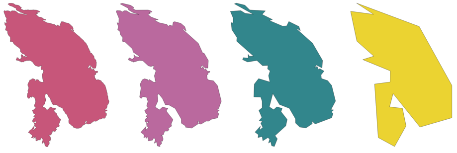
Fig. 24.106 From left to right, source layer and increasing simplification tolerances
Allows features in-place modification
of line and polygon features
Numatytas meniu:
Taip pat žiūrėkite
Paprastinti padengimą, Smooth, Densify by count, Densify by interval
Parametrai
Užrašas |
Pavadinimas |
Tipas |
Aprašymas |
|---|---|---|---|
Įvesties sluoksnis |
|
[vektorius: linija, poligonas] |
Įvesties linijų ar poligonų vektorinis sluoksnis |
Simplification method |
|
[sąrašas] Numatytas: 0 |
Simplification method. One of:
|
Tolerancija |
|
[skaičius: slankaus kablelio] Numatytas: 1.0 |
Threshold tolerance (in units of the layer): if the distance between two nodes is smaller than the tolerance value, the segment will be simplified and vertices will be removed. |
Supaprastinta |
|
[toks pat, kaip įvestis] Numatytas: |
Specify the output (simplified) vector layer. One of:
Čia taipogi galima pakeisti failo koduotę. |
Išvestys
Užrašas |
Pavadinimas |
Tipas |
Aprašymas |
|---|---|---|---|
Supaprastinta |
|
[toks pat, kaip įvestis] |
The output (simplified) vector layer |
Pythono kodas
Algorithm ID: native:simplifygeometries
import processing
processing.run("algorithm_id", {parameter_dictionary})
algoritmo id rodomas, kai užvedate pelę virš algoritmo apdorojimo įrankinėje. parametrų žodynas teikia parametrų pavadinimus ir reikšmes. Daugiau informacijos apie tai, kaip vykdyti apdorojimo algoritmus Pythono konsolėje rasite skyriuje Using processing algorithms from the console.
24.1.23.69. Single sided buffer
Computes a buffer on lines by a specified distance on one side of the line only.
Buffer always results in a polygon layer.
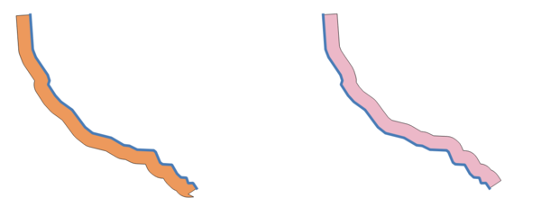
Fig. 24.107 Left versus right side buffer on the same vector line layer
Taip pat žiūrėkite
Parametrai
Užrašas |
Pavadinimas |
Tipas |
Aprašymas |
|---|---|---|---|
Įvesties sluoksnis |
|
[vektorius: linija] |
Įvesties vektorinis linijų sluoksnis |
Atstumas |
|
[skaičius: slankaus kablelio] Numatytas: 10.0 |
Buffer distance. |
Side |
|
[sąrašas] Numatytas: 0 |
Which side to create the buffer on. One of:
|
Segmentai |
|
[skaičius: sveikas skaičius] Numatyta: 8 |
Valdo skaičių linijų segmentų, kurie naudojami aproksimuojant apskritimo ketvirčius kuriant užapvalintus poslinkius. |
Jungimo stilius |
|
[sąrašas] Numatytas: 0 |
Nurodo, ar paslinkus linijos kampus reikia naudoti apvalias, mitros ar kampines jungtis. Parinktys yra:
Fig. 24.108 Apvalūs, mitros ir kampo jungimo stiliai |
Mitros riba |
|
[skaičius: slankaus kablelio] Numatyta: 2.0 |
Nustato maksimalų atstumą nuo paslenkamos geometrijos kuriant mitros jungtį. Nurodomas kaip poslinkio atstumo koeficientas (taikoma tik mitros jungimo stiliui). Minimalus: 1.0
Fig. 24.109 10m buferis su 2 riba ir 10m buferis su 1 riba |
Buferis |
|
[vektorius: poligonas] Numatytas: |
Nurodykite išvesties (buferių) sluoksnį. Vienas iš:
Čia taipogi galima pakeisti failo koduotę. |
Išvestys
Užrašas |
Pavadinimas |
Tipas |
Aprašymas |
|---|---|---|---|
Buferis |
|
[vektorius: poligonas] |
Išvesties (buferių) poligonų sluoksnis |
Pythono kodas
Algorithm ID: native:singlesidedbuffer
import processing
processing.run("algorithm_id", {parameter_dictionary})
algoritmo id rodomas, kai užvedate pelę virš algoritmo apdorojimo įrankinėje. parametrų žodynas teikia parametrų pavadinimus ir reikšmes. Daugiau informacijos apie tai, kaip vykdyti apdorojimo algoritmus Pythono konsolėje rasite skyriuje Using processing algorithms from the console.
24.1.23.70. Smooth
Smooths the geometries in a line or polygon layer by adding more vertices and corners to the feature geometries.
The iterations parameter dictates how many smoothing iterations will be applied to each geometry. A higher number of iterations results in smoother geometries with the cost of greater number of nodes in the geometries.
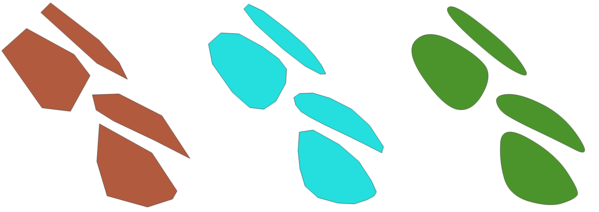
Fig. 24.110 Increasing number of iterations causes smoother geometries
The offset parameter controls how „tightly“ the smoothed geometries follow the original geometries. Smaller values results in a tighter fit, and larger values will create a looser fit.
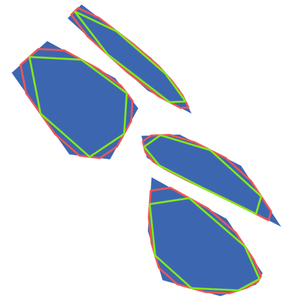
Fig. 24.111 Blue: the input layer. Offset 0.25 gives the red line, while offset 0.50 gives the green line.
The maximum angle parameter can be used to prevent smoothing of nodes with large angles. Any node where the angle of the segments to either side is larger than this will not be smoothed. For example, setting the maximum angle to 90 degrees or lower would preserve right angles in the geometry.
Allows
features in-place modification
of line and polygon features
Taip pat žiūrėkite
Simplify, Paprastinti padengimą, Densify by count, Densify by interval
Parametrai
Užrašas |
Pavadinimas |
Tipas |
Aprašymas |
|---|---|---|---|
Įvesties sluoksnis |
|
[vektorius: linija, poligonas] |
Įvesties linijų ar poligonų vektorinis sluoksnis |
Iterations |
|
[skaičius: sveikas skaičius] Numatytas: 1 |
Increasing the number of iterations will give smoother geometries (and more vertices). |
Offset |
|
[skaičius: slankaus kablelio] Numatyta: 0.25 |
Increasing values will move the smoothed lines / boundaries further away from the input lines / boundaries. |
Maximum node angle to smooth |
|
[skaičius: slankaus kablelio] Default: 180.0 |
Every node below this value will be smoothed |
Smoothed |
|
[toks pat, kaip įvestis] Numatytas: |
Specify the output (smoothed) layer. One of:
Čia taipogi galima pakeisti failo koduotę. |
Išvestys
Užrašas |
Pavadinimas |
Tipas |
Aprašymas |
|---|---|---|---|
Smoothed |
|
[toks pat, kaip įvestis] |
Output (smoothed) vector layer |
Pythono kodas
Algorithm ID: native:smoothgeometry
import processing
processing.run("algorithm_id", {parameter_dictionary})
algoritmo id rodomas, kai užvedate pelę virš algoritmo apdorojimo įrankinėje. parametrų žodynas teikia parametrų pavadinimus ir reikšmes. Daugiau informacijos apie tai, kaip vykdyti apdorojimo algoritmus Pythono konsolėje rasite skyriuje Using processing algorithms from the console.
24.1.23.71. Snap geometries to layer
Snaps the geometries in a layer either to the geometries from another layer, or to geometries within the same layer.
Matching is done based on a tolerance distance, and vertices will be inserted or removed as required to make the geometries match the reference geometries.
Leidžia taškų, linijų ir poligonų geoobjektus keisti vietoje
Taip pat žiūrėkite
Parametrai
Užrašas |
Pavadinimas |
Tipas |
Aprašymas |
|---|---|---|---|
Įvesties sluoksnis |
|
[vektorius: geometrija] |
Įvesties vektorinis sluoksnis |
Atskaitos sluoksnis |
|
[vektorius: geometrija] |
Vector layer to snap to |
Tolerancija |
|
[skaičius: slankaus kablelio] Numatytas: 10.0 |
Control how close input vertices need to be to the reference layer geometries before they are snapped. |
Behavior |
|
[sąrašas] Numatytas: 0 |
Snapping can be done to an existing node or a segment (its closest point to the vertex to move). Available snapping options:
|
Snapped geometry |
|
[toks pat, kaip įvestis] Numatytas: |
Specify the output (snapped) layer. One of:
Čia taipogi galima pakeisti failo koduotę. |
Išvestys
Užrašas |
Pavadinimas |
Tipas |
Aprašymas |
|---|---|---|---|
Snapped geometry |
|
[toks pat, kaip įvestis] |
Output (snapped) vector layer |
Pythono kodas
Algorithm ID: native:snapgeometries
import processing
processing.run("algorithm_id", {parameter_dictionary})
algoritmo id rodomas, kai užvedate pelę virš algoritmo apdorojimo įrankinėje. parametrų žodynas teikia parametrų pavadinimus ir reikšmes. Daugiau informacijos apie tai, kaip vykdyti apdorojimo algoritmus Pythono konsolėje rasite skyriuje Using processing algorithms from the console.
24.1.23.72. Snap points to grid
Modifies the coordinates of geometries in a vector layer, so that all points or vertices are snapped to the closest point of a grid.
If the snapped geometry cannot be calculated (or is totally collapsed) the feature’s geometry will be cleared.
Snapping can be performed on the X, Y, Z or M axis. A grid spacing of 0 for any axis will disable snapping for that axis.
Leidžia taškų, linijų ir poligonų geoobjektus keisti vietoje
Įspėjimas
Snapping to grid may generate an invalid geometry in some corner cases.
Taip pat žiūrėkite
Parametrai
Užrašas |
Pavadinimas |
Tipas |
Aprašymas |
|---|---|---|---|
Įvesties sluoksnis |
|
[vektorius: geometrija] |
Įvesties vektorinis sluoksnis |
X Grid Spacing |
|
[skaičius: slankaus kablelio] Numatytas: 1.0 |
Grid spacing on the X axis |
Y Grid Spacing |
|
[skaičius: slankaus kablelio] Numatytas: 1.0 |
Grid spacing on the Y axis |
Z Grid Spacing |
|
[skaičius: slankaus kablelio] Numatytas: 0.0 |
Grid spacing on the Z axis |
M Grid Spacing |
|
[skaičius: slankaus kablelio] Numatytas: 0.0 |
Grid spacing on the M axis |
Snapped |
|
[toks pat, kaip įvestis] Numatytas: |
Specify the output (snapped) layer. One of:
Čia taipogi galima pakeisti failo koduotę. |
Išvestys
Užrašas |
Pavadinimas |
Tipas |
Aprašymas |
|---|---|---|---|
Snapped |
|
[toks pat, kaip įvestis] |
Output (snapped) vector layer |
Pythono kodas
Algorithm ID: native:snappointstogrid
import processing
processing.run("algorithm_id", {parameter_dictionary})
algoritmo id rodomas, kai užvedate pelę virš algoritmo apdorojimo įrankinėje. parametrų žodynas teikia parametrų pavadinimus ir reikšmes. Daugiau informacijos apie tai, kaip vykdyti apdorojimo algoritmus Pythono konsolėje rasite skyriuje Using processing algorithms from the console.
24.1.23.73. Split lines by maximum length
Takes a line (or curve) layer and splits each feature into multiple parts, where each part is of a specified maximum length. Z and M values at the start and end of the new line substrings are linearly interpolated from existing values.
Leidžia linijų geoobjektus keisti vietoje
Įspėjimas
Šis algoritmas išmeta esamus pirminius raktus ar FID reikšmes ir perkuria jas išvesties sluoksniuose.
Parametrai
Užrašas |
Pavadinimas |
Tipas |
Aprašymas |
|---|---|---|---|
Įvesties sluoksnis |
|
[vektorius: linija] |
The input line vector layer |
Maximum line length |
|
[skaičius: slankaus kablelio] Numatytas: 10.0 |
The maximum length of a line in the output. |
Split |
|
[vektorius: linija] Numatytas: |
Specify the output line vector layer. One of:
Čia taipogi galima pakeisti failo koduotę. |
Išvestys
Užrašas |
Pavadinimas |
Tipas |
Aprašymas |
|---|---|---|---|
Split |
|
[vektorius: linija] |
The new line vector layer.
The length of the feature geometries is less than or equal to the length
specified in the LENGTH parameter. An additional field containing the
|
Pythono kodas
Algorithm ID: native:splitlinesbylength
import processing
processing.run("algorithm_id", {parameter_dictionary})
algoritmo id rodomas, kai užvedate pelę virš algoritmo apdorojimo įrankinėje. parametrų žodynas teikia parametrų pavadinimus ir reikšmes. Daugiau informacijos apie tai, kaip vykdyti apdorojimo algoritmus Pythono konsolėje rasite skyriuje Using processing algorithms from the console.
24.1.23.74. Subdivide
Subdivides the geometry. The returned geometry will be a collection containing subdivided parts from the original geometry, where no part has more than the specified maximum number of nodes.
This is useful for dividing a complex geometry into less complex parts, easier to spatially index and faster to perform spatial operations. Curved geometries will be segmentized before subdivision.
Fig. 24.112 Left the input layer, middle maximum nodes value is 100 and right maximum value is 200
Leidžia taškų, linijų ir poligonų geoobjektus keisti vietoje
Pastaba
Subdividing a geometry can generate geometry parts that may not be valid and may contain self-intersections.
Taip pat žiūrėkite
Parametrai
Užrašas |
Pavadinimas |
Tipas |
Aprašymas |
|---|---|---|---|
Įvesties sluoksnis |
|
[vektorius: geometrija] |
Įvesties vektorinis sluoksnis |
Maximum nodes in parts |
|
[skaičius: sveikas skaičius] Default: 256 |
Maximum number of vertices each new geometry part is allowed to have. Fewer sub-parts for higher values. |
Subdivided |
|
[toks pat, kaip įvestis] Numatytas: |
Specify the output (subdivided) vector layer. One of:
Čia taipogi galima pakeisti failo koduotę. |
Išvestys
Užrašas |
Pavadinimas |
Tipas |
Aprašymas |
|---|---|---|---|
Subdivided |
|
[toks pat, kaip įvestis] |
Output vector layer |
Pythono kodas
Algorithm ID: native:subdivide
import processing
processing.run("algorithm_id", {parameter_dictionary})
algoritmo id rodomas, kai užvedate pelę virš algoritmo apdorojimo įrankinėje. parametrų žodynas teikia parametrų pavadinimus ir reikšmes. Daugiau informacijos apie tai, kaip vykdyti apdorojimo algoritmus Pythono konsolėje rasite skyriuje Using processing algorithms from the console.
24.1.23.75. Swap X and Y coordinates
Switches the X and Y coordinate values in input geometries.
It can be used to repair geometries which have accidentally had their latitude and longitude values reversed.
Leidžia taškų, linijų ir poligonų geoobjektus keisti vietoje
Parametrai
Užrašas |
Pavadinimas |
Tipas |
Aprašymas |
|---|---|---|---|
Įvesties sluoksnis |
|
[vektorius: geometrija] |
Įvesties vektorinis sluoksnis |
Swapped |
|
[toks pat, kaip įvestis] Numatytas: |
Nurodykite išvesties vektorinį sluoksnį Vienas iš:
Čia taipogi galima pakeisti failo koduotę. |
Išvestys
Užrašas |
Pavadinimas |
Tipas |
Aprašymas |
|---|---|---|---|
Swapped |
|
[toks pat, kaip įvestis] |
Output (swapped) vector layer |
Pythono kodas
Algorithm ID: native:swapxy
import processing
processing.run("algorithm_id", {parameter_dictionary})
algoritmo id rodomas, kai užvedate pelę virš algoritmo apdorojimo įrankinėje. parametrų žodynas teikia parametrų pavadinimus ir reikšmes. Daugiau informacijos apie tai, kaip vykdyti apdorojimo algoritmus Pythono konsolėje rasite skyriuje Using processing algorithms from the console.
24.1.23.76. Tapered buffers
Creates tapered buffer along line geometries, using a specified start and end buffer diameter.
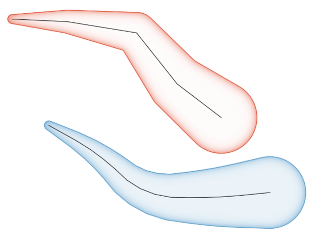
Fig. 24.113 Tapered buffer example
Taip pat žiūrėkite
Variable width buffer (by M value), Buferis, Create wedge buffers
Parametrai
Užrašas |
Pavadinimas |
Tipas |
Aprašymas |
|---|---|---|---|
Įvesties sluoksnis |
|
[vektorius: linija] |
Įvesties vektorinis linijų sluoksnis |
Start width |
|
[skaičius: slankaus kablelio] Numatytas: 0.0 |
Represents the radius of the buffer applied at the start point of the line feature |
End width |
|
[skaičius: slankaus kablelio] Numatytas: 0.0 |
Represents the radius of the buffer applied at the end point of the line feature. |
Segmentai |
|
[skaičius: sveikas skaičius] Default: 16 |
Valdo skaičių linijų segmentų, kurie naudojami aproksimuojant apskritimo ketvirčius kuriant užapvalintus poslinkius. |
Buferiai |
|
[vektorius: poligonas] Numatytas: |
Nurodykite išvesties (buferių) sluoksnį. Vienas iš:
Čia taipogi galima pakeisti failo koduotę. |
Išvestys
Užrašas |
Pavadinimas |
Tipas |
Aprašymas |
|---|---|---|---|
Buferiai |
|
[vektorius: poligonas] |
Išvesties (buferių) poligonų sluoksnis |
Pythono kodas
Algorithm ID: native:taperedbuffer
import processing
processing.run("algorithm_id", {parameter_dictionary})
algoritmo id rodomas, kai užvedate pelę virš algoritmo apdorojimo įrankinėje. parametrų žodynas teikia parametrų pavadinimus ir reikšmes. Daugiau informacijos apie tai, kaip vykdyti apdorojimo algoritmus Pythono konsolėje rasite skyriuje Using processing algorithms from the console.
24.1.23.77. Tessellate
Tessellates a polygon geometry layer, dividing the geometries into triangular components.
The output layer consists of multipolygon geometries for each input feature, with each multipolygon consisting of multiple triangle component polygons.
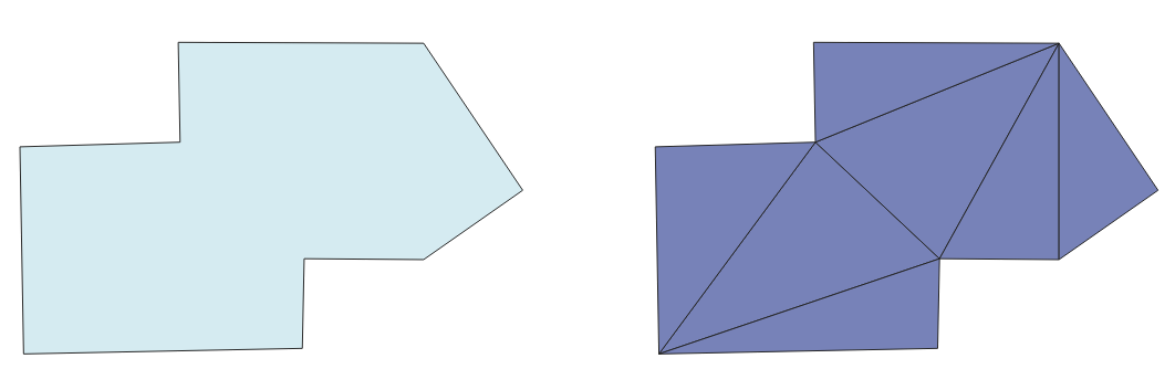
Fig. 24.114 Tessellated polygon (right)
Leidžia vietoje keisti poligonų geoobjektus
Parametrai
Užrašas |
Pavadinimas |
Tipas |
Aprašymas |
|---|---|---|---|
Įvesties sluoksnis |
|
[vektorius: poligonas] |
Įvesties poligonų vektorinis sluoksnis |
Tesselated |
|
[vektorius: poligonas] Numatytas: |
Nurodykite išvesties sluoksnį. Vienas iš:
Čia taipogi galima pakeisti failo koduotę. |
Išvestys
Užrašas |
Pavadinimas |
Tipas |
Aprašymas |
|---|---|---|---|
Tesselated |
|
[vektorius: poligonas] |
Output multipolygonZ layer |
Pythono kodas
Algorithm ID: 3d:tessellate
import processing
processing.run("algorithm_id", {parameter_dictionary})
algoritmo id rodomas, kai užvedate pelę virš algoritmo apdorojimo įrankinėje. parametrų žodynas teikia parametrų pavadinimus ir reikšmes. Daugiau informacijos apie tai, kaip vykdyti apdorojimo algoritmus Pythono konsolėje rasite skyriuje Using processing algorithms from the console.
24.1.23.78. Transect
Creates transects on vertices for (multi)linestring.
A transect is a line oriented from an angle (by default perpendicular) to the input polylines (at vertices).
Field(s) from feature(s) are returned in the transect with these new fields:
TR_FID: ID of the original feature
TR_ID: ID of the transect. Each transect have an unique ID
TR_SEGMENT: ID of the segment of the linestring
TR_ANGLE: Angle in degrees from the original line at the vertex
TR_LENGTH: Total length of the transect returned
TR_ORIENT: Side of the transect (only on the left or right of the line, or both side)
Įspėjimas
Šis algoritmas išmeta esamus pirminius raktus ar FID reikšmes ir perkuria jas išvesties sluoksniuose.
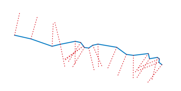
Fig. 24.115 Dashed red lines represent the transect of the input line layer
Parametrai
Užrašas |
Pavadinimas |
Tipas |
Aprašymas |
|---|---|---|---|
Įvesties sluoksnis |
|
[vektorius: linija] |
Įvesties vektorinis linijų sluoksnis |
Length of the transect |
|
[skaičius: slankaus kablelio] Default: 5.0 |
Length in map unit of the transect |
Angle in degrees from the original line at the vertices |
|
[skaičius: slankaus kablelio] Default: 90.0 |
Change the angle of the transect |
Side to create the transect |
|
[sąrašas] |
Choose the side of the transect. Available options are:
|
Transect |
|
[vektorius: linija] Numatytas: |
Specify the output line layer. One of:
Čia taipogi galima pakeisti failo koduotę. |
Išvestys
Užrašas |
Pavadinimas |
Tipas |
Aprašymas |
|---|---|---|---|
Transect |
|
[vektorius: linija] |
Output line layer |
Pythono kodas
Algorithm ID: native:transect
import processing
processing.run("algorithm_id", {parameter_dictionary})
algoritmo id rodomas, kai užvedate pelę virš algoritmo apdorojimo įrankinėje. parametrų žodynas teikia parametrų pavadinimus ir reikšmes. Daugiau informacijos apie tai, kaip vykdyti apdorojimo algoritmus Pythono konsolėje rasite skyriuje Using processing algorithms from the console.
24.1.23.79. Translate
Moves the geometries within a layer, by offsetting with a predefined X and Y displacement.
Z and M values present in the geometry can also be translated.
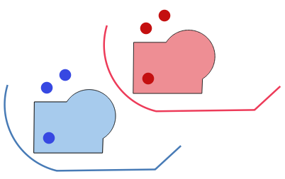
Fig. 24.116 Features in red represent the translated geometry of the input (blue) layer
Leidžia taškų, linijų ir poligonų geoobjektus keisti vietoje
Taip pat žiūrėkite
Pakeistų geoobjektų masyvas, Offset lines, Rotate, Swap X and Y coordinates
Parametrai
Užrašas |
Pavadinimas |
Tipas |
Aprašymas |
|---|---|---|---|
Įvesties sluoksnis |
|
[vektorius: geometrija] |
Įvesties vektorinis sluoksnis |
Offset distance (x-axis) |
|
[skaičius: slankaus kablelio] Numatytas: 0.0 |
X ašyje taikomas poslinkis |
Offset distance (y-axis) |
|
[skaičius: slankaus kablelio] Numatytas: 0.0 |
Y ašyje taikomas poslinkis |
Offset distance (z-axis) |
|
[skaičius: slankaus kablelio] Numatytas: 0.0 |
Z ašyje taikomas poslinkis |
Offset distance (m values) |
|
[skaičius: slankaus kablelio] Numatytas: 0.0 |
Displacement to apply on the M axis |
Pakeista |
|
[toks pat, kaip įvestis] Numatytas: |
Nurodykite išvesties vektorinį sluoksnį Vienas iš:
Čia taipogi galima pakeisti failo koduotę. |
Išvestys
Užrašas |
Pavadinimas |
Tipas |
Aprašymas |
|---|---|---|---|
Pakeista |
|
[toks pat, kaip įvestis] |
Output vector layer |
Pythono kodas
Algorithm ID: native:translategeometry
import processing
processing.run("algorithm_id", {parameter_dictionary})
algoritmo id rodomas, kai užvedate pelę virš algoritmo apdorojimo įrankinėje. parametrų žodynas teikia parametrų pavadinimus ir reikšmes. Daugiau informacijos apie tai, kaip vykdyti apdorojimo algoritmus Pythono konsolėje rasite skyriuje Using processing algorithms from the console.
24.1.23.80. Variable width buffer (by M value)
Creates variable width buffers along lines, using the M value of the line geometries as the diameter of the buffer at each vertex.
Fig. 24.117 Variable buffer example
Taip pat žiūrėkite
Tapered buffers, Buferis, Set M value, Variable distance buffer
Parametrai
Užrašas |
Pavadinimas |
Tipas |
Aprašymas |
|---|---|---|---|
Įvesties sluoksnis |
|
[vektorius: linija] |
Įvesties vektorinis linijų sluoksnis |
Segmentai |
|
[skaičius: sveikas skaičius] Default: 16 |
Number of the buffer segments per quarter circle. It can be a unique value (same value for all the features), or it can be taken from features data (the value can depend on feature attributes). |
Buferiai |
|
[vektorius: poligonas] Numatytas: |
Nurodykite išvesties (buferių) sluoksnį. Vienas iš:
Čia taipogi galima pakeisti failo koduotę. |
Išvestys
Užrašas |
Pavadinimas |
Tipas |
Aprašymas |
|---|---|---|---|
Buferiai |
|
[vektorius: poligonas] |
Variable buffer polygon layer |
Pythono kodas
Algorithm ID: native:bufferbym
import processing
processing.run("algorithm_id", {parameter_dictionary})
algoritmo id rodomas, kai užvedate pelę virš algoritmo apdorojimo įrankinėje. parametrų žodynas teikia parametrų pavadinimus ir reikšmes. Daugiau informacijos apie tai, kaip vykdyti apdorojimo algoritmus Pythono konsolėje rasite skyriuje Using processing algorithms from the console.
24.1.23.81. Voronoi polygons
Takes a point layer and generates a polygon layer containing the Voronoi polygons (known also as Thiessen polygons) corresponding to those input points.
Any location within a Voronoi polygon is closer to the associated point than to any other point.
Fig. 24.118 Voronoi polygons
Numatytas meniu:
Parametrai
Užrašas |
Pavadinimas |
Tipas |
Aprašymas |
|---|---|---|---|
Įvesties sluoksnis |
|
[vektorius: taškas] |
Input point vector layer |
Buffer region (% of extent) |
|
[skaičius: slankaus kablelio] Numatytas: 0.0 |
The extent of the output layer will be this much bigger than the extent of the input layer |
Tolerancija Pasirinktinis |
|
[skaičius: slankaus kablelio] Numatytas: 0.0 |
Specifies an optional snapping tolerance which can be used to improve the robustness of the voronoi. |
Copy attributes from input features |
|
[loginis] Numatytas: Taip |
Specifies whether fields storing involved point features ID should be added to the output.
If False, an |
Voronoi polygons |
|
[vektorius: poligonas] Numatytas: |
Specify the output layer (with the Voronoi polygons). One of:
Čia taipogi galima pakeisti failo koduotę. |
Išvestys
Užrašas |
Pavadinimas |
Tipas |
Aprašymas |
|---|---|---|---|
Voronoi polygons |
|
[vektorius: poligonas] |
Voronoi polygons of the input point vector layer |
Pythono kodas
Algorithm ID: native:voronoipolygons
import processing
processing.run("algorithm_id", {parameter_dictionary})
algoritmo id rodomas, kai užvedate pelę virš algoritmo apdorojimo įrankinėje. parametrų žodynas teikia parametrų pavadinimus ir reikšmes. Daugiau informacijos apie tai, kaip vykdyti apdorojimo algoritmus Pythono konsolėje rasite skyriuje Using processing algorithms from the console.