Svarbu
Vertimas yra bendruomenės pastangos, prie kurių jūs galite prisijungti. Šis puslapis šiuo metu išverstas 79.03%.
24.1.18. Rastro įrankiai
24.1.18.1. Lygiuoti rastrą
Lygiuoja rastrą perrenkant jį į tokį patį celių dydį ir perprojektuojant į tą pačią CRS kaip ir atskaitos rastras.
Įspėjimas
Šis algoritmas veikia TIK Modelių dizainerio kontekste. Kituose kontekstuose naudokite Lygiuoti rastrus.
Parametrai
Užrašas |
Pavadinimas |
Tipas |
Aprašymas |
|---|---|---|---|
Įvesties sluoksnis |
|
[rastras] |
Lygiuojamas įvesties rastras |
Perrinkimo metodas |
|
[sąrašas] Numatytas: 0 |
Method to use for input layer resampling.
|
Perskaičiuoti reikšmes pagal celės dydį |
|
[boolean] Numatytas: Ne |
|
Atskaitos sluoksnis |
|
[rastras] |
Rastro sluoksnis, kuris bus naudotas ištraukti apimčiai, celių dydžiui ir CRS, kurie bus taikomi įvesties sluoksniams. |
Permušti atskaitos CRS Pasirinktinis |
|
[crs] |
CRS, kurį naudoti vietoje rasto atskaitos sluoksnyje |
Permušti atskaitos celės dydį X Pasirinktinis |
|
[skaičius: slankaus kablelio] |
Celės dydis X kryptimi bus naudojamas vietoje rasto apskaitos sluoksnyje |
Permušti atskaitos celės dydį Y Pasirinktinis |
|
[skaičius: slankaus kablelio] |
Celės dydis Y kryptimi bus naudojamas vietoje rasto apskaitos sluoksnyje |
Permušti atskaitos tinklelio poslinkį X Pasirinktinis |
|
[skaičius: slankaus kablelio] |
Poslinkis X kryptimi, kurį taikyti celių tinkleliui |
Permušti atskaitos tinklelio poslinkį Y Pasirinktinis |
|
[skaičius: slankaus kablelio] |
Poslinkis Y kryptimi, kurį taikyti celių tinkleliui |
Apkarpyti pagal apimtį Pasirinktinis |
|
[apimtis] |
Nurodykite išvesties rastro sluoksnio apimtį. Ji viduje bus išplėsta iki kaladėlės dydžio kartotinio. Galimi metodai yra:
|
Sulygiuotas rastras |
|
[rastras] |
išvesties rastras su perrikiuotais taškais |
Išvestys
Užrašas |
Pavadinimas |
Tipas |
Aprašymas |
|---|---|---|---|
Sulygiuotas rastras |
|
[rastras] |
išvesties rastras su perrikiuotais taškais |
Pythono kodas
Algoritmo ID: native:alignsingleraster
import processing
processing.run("algorithm_id", {parameter_dictionary})
algoritmo id rodomas, kai užvedate pelę virš algoritmo apdorojimo įrankinėje. parametrų žodynas teikia parametrų pavadinimus ir reikšmes. Daugiau informacijos apie tai, kaip vykdyti apdorojimo algoritmus Pythono konsolėje rasite skyriuje Using processing algorithms from the console.
24.1.18.2. Lygiuoti rastrus
Lygiuoja rastrus perrenkant juos į tokį patį celių dydį ir perprojektuojant į tą pačią CRS kaip ir atskaitos rastras.
Įspėjimas
Šis algoritmas NEVEIKIA Modelių dizainerio kontekste. Vietoje to naudokite Lygiuoti rastrą.
Parametrai
Užrašas |
Pavadinimas |
Tipas |
Aprašymas |
|---|---|---|---|
Įvesties sluoksniai |
|
[rastras] [sąrašas] |
Sąrašas įvesties rastrų su susijusiomis perrinkimo parinktimis (užpildytomis kaip
Mastelio keitimo reikšmės pagal celės dydį [loginis] ( |
Atskaitos sluoksnis |
|
[rastras] |
Rastro sluoksnis, kuris bus naudotas ištraukti apimčiai, celių dydžiui ir CRS, kurie bus taikomi įvesties sluoksniams. |
Permušti atskaitos CRS Pasirinktinis |
|
[crs] |
CRS, kurį naudoti vietoje rasto atskaitos sluoksnyje |
Permušti atskaitos celės dydį X Pasirinktinis |
|
[skaičius: slankaus kablelio] |
Celės dydis X kryptimi bus naudojamas vietoje rasto apskaitos sluoksnyje |
Permušti atskaitos celės dydį Y Pasirinktinis |
|
[skaičius: slankaus kablelio] |
Celės dydis Y kryptimi bus naudojamas vietoje rasto apskaitos sluoksnyje |
Permušti atskaitos tinklelio poslinkį X Pasirinktinis |
|
[skaičius: slankaus kablelio] |
Poslinkis X kryptimi, kurį taikyti celių tinkleliui |
Permušti atskaitos tinklelio poslinkį Y Pasirinktinis |
|
[skaičius: slankaus kablelio] |
Poslinkis Y kryptimi, kurį taikyti celių tinkleliui |
Apkarpyti pagal apimtį Pasirinktinis |
|
[apimtis] |
Nurodykite išvesties rastro sluoksnio apimtį. Ji viduje bus išplėsta iki kaladėlės dydžio kartotinio. Galimi metodai yra:
|
Išvestys
Užrašas |
Pavadinimas |
Tipas |
Aprašymas |
|---|---|---|---|
Lygiuoti rastrai |
|
[rastras] [sąrašas] |
išvesties rastrai su perrinktais pikseliais |
Pythono kodas
Algoritmo ID: native:alignrasters
import processing
processing.run("algorithm_id", {parameter_dictionary})
algoritmo id rodomas, kai užvedate pelę virš algoritmo apdorojimo įrankinėje. parametrų žodynas teikia parametrų pavadinimus ir reikšmes. Daugiau informacijos apie tai, kaip vykdyti apdorojimo algoritmus Pythono konsolėje rasite skyriuje Using processing algorithms from the console.
24.1.18.3. Convert map to raster
Creates a raster image of map canvas content.
A map theme can be selected to render a predetermined set of layers with a defined style for each layer.
Alternatively, a single layer can be selected if no map theme is set.
If neither map theme nor layer is set, the current map content will be rendered. The minimum extent entered will internally be extended to be a multiple of the tile size.
Parametrai
Užrašas |
Pavadinimas |
Tipas |
Aprašymas |
|---|---|---|---|
Minimum extent to render (xmin, xmax, ymin, ymax) |
|
[apimtis] |
Nurodykite išvesties rastro sluoksnio apimtį. Ji viduje bus išplėsta iki kaladėlės dydžio kartotinio. Galimi metodai yra:
|
Tile size |
|
[skaičius: sveikas skaičius] Default: 1024 |
Size of the tile of the output raster layer. Minimum value: 64. |
Map units per pixel |
|
[skaičius: slankaus kablelio] Numatytas: 100.0 |
Pixel size (in map units). Minimum value: 0.0 |
Make background transparent |
|
[boolean] Numatytas: ne |
Allows exporting the map with a transparent background.
Outputs an RGBA (instead of RGB) image if set to |
Map theme to render Pasirinktinis |
|
[sąrašas] |
Use an existing map theme for the rendering. |
Single layer to render Pasirinktinis |
|
[sąrašas] |
Choose a single layer for the rendering |
Išvesties sluoksnis |
|
[rastras] Numatytas: |
Išvesties rastro specifikacija. Vienas iš:
|
Išvestys
Užrašas |
Pavadinimas |
Tipas |
Aprašymas |
|---|---|---|---|
Išvesties sluoksnis |
|
[rastras] |
Išvesties rastro sluoksnis |
Pythono kodas
Algorithm ID: native:rasterize
import processing
processing.run("algorithm_id", {parameter_dictionary})
algoritmo id rodomas, kai užvedate pelę virš algoritmo apdorojimo įrankinėje. parametrų žodynas teikia parametrų pavadinimus ir reikšmes. Daugiau informacijos apie tai, kaip vykdyti apdorojimo algoritmus Pythono konsolėje rasite skyriuje Using processing algorithms from the console.
24.1.18.4. Fill NoData cells
Resets the NoData values in the input raster to a chosen value, resulting in raster dataset with no NoData pixels.
The algorithm respects the input raster data type, e.g. a floating point fill value will be truncated when applied to an integer raster.
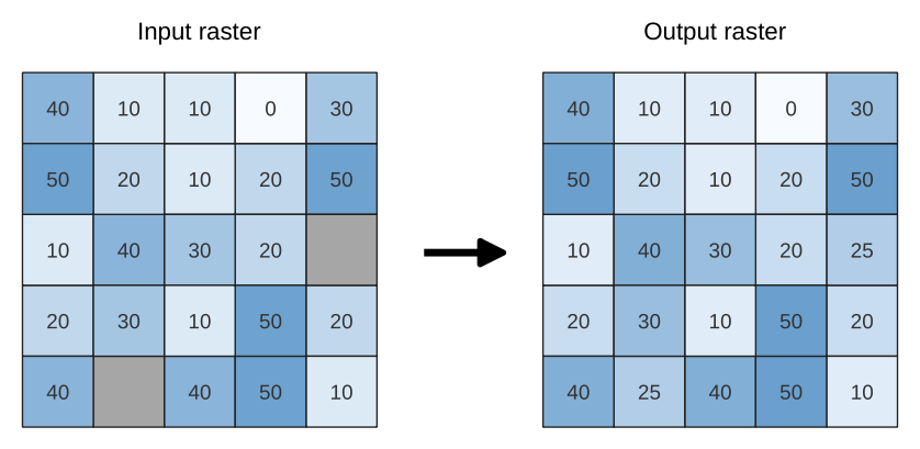
Fig. 24.39 Filling NoData values (in grey) of a raster
Parametrai
Baziniai parametrai
Užrašas |
Pavadinimas |
Tipas |
Aprašymas |
|---|---|---|---|
Input raster |
|
[rastras] |
The raster to process. |
Juostos numeris |
|
[rastro juosta] Numatytas: 1 |
The band of the raster |
Fill value |
|
[skaičius: slankaus kablelio] Numatytas: 1.0 |
Set the value to use for the NoData pixels |
Išvesties rastras |
|
[rastras] Numatytas: |
Išvesties rastro specifikacija. Vienas iš:
|
Išmanesni parametrai
Užrašas |
Pavadinimas |
Tipas |
Aprašymas |
|---|---|---|---|
Kūrimo parinktys Pasirinktinis |
|
[tekstas] Numatytas: ‚‘ |
Norint pridėti vieną ar daugiau kūrimo parinkčių, valdančių rastro kūrimą (spalvos, bloko dydis, failo suspaudimas…). Patogumui jūs galite remtis iš anksto sukurtais profiliais (žiūrėkite GDAL tvarkyklės parinkčių skiltį). Paketinis apdorojimas ir Modelių kūrimas: atskirkite kelias parinktis statmenu brūkšniu ( |
Išvestys
Užrašas |
Pavadinimas |
Tipas |
Aprašymas |
|---|---|---|---|
Išvesties rastras |
|
[rastras] |
The output raster layer with filled data cells. |
Pythono kodas
Algorithm ID: native:fillnodata
import processing
processing.run("algorithm_id", {parameter_dictionary})
algoritmo id rodomas, kai užvedate pelę virš algoritmo apdorojimo įrankinėje. parametrų žodynas teikia parametrų pavadinimus ir reikšmes. Daugiau informacijos apie tai, kaip vykdyti apdorojimo algoritmus Pythono konsolėje rasite skyriuje Using processing algorithms from the console.
24.1.18.5. Generate XYZ tiles (Directory)
Generates raster “XYZ” tiles using the current QGIS project as individual images to a directory structure.
Optionally, a Leaflet HTML output file using the generated tiles as a map layer could be created.
Parametrai
Baziniai parametrai
Užrašas |
Pavadinimas |
Tipas |
Aprašymas |
|---|---|---|---|
Apimtis (xmin, xmax, ymin, ymax) |
|
[apimtis] |
Specify the extent of the tiles. It will internally be extended to a multiple of the tile size. Galimi metodai yra:
|
Minimum zoom |
|
[skaičius: sveikas skaičius] Default: 12 |
Minimum 0, maximum 25. |
Maximum zoom |
|
[skaičius: sveikas skaičius] Default: 12 |
Minimum 0, maximum 25. |
DPI |
|
[skaičius: sveikas skaičius] Default: 96 |
Minimum 48, maximum 600. |
Background color Pasirinktinis |
|
[color] Default: QColor(0, 0, 0, 0) |
Choose the background color for the tiles |
Enable antialiasing |
|
[boolean] Numatytas: Taip |
Determines if antialiasing should be enabled |
Tile format |
|
[sąrašas] Numatytas: 0 |
Vienas iš:
|
Quality (JPG only) Pasirinktinis |
|
[skaičius: sveikas skaičius] Default: 75 |
Minimum 1, maximum 100. |
Metatile size Pasirinktinis |
|
[skaičius: sveikas skaičius] Default: 4 |
Specify a custom metatile size when generating XYZ tiles. Larger values may speed up the rendering of tiles and provide better labelling (fewer gaps without labels) at the expense of using more memory. Minimum 1, maximum 20. |
Tile width Pasirinktinis |
|
[skaičius: sveikas skaičius] Default: 256 |
Minimum 1, maximum 4096. |
Tile height Pasirinktinis |
|
[skaičius: sveikas skaičius] Default: 256 |
Minimum 1, maximum 4096. |
Use inverted tile Y axis (TMS conventions) |
|
[boolean] Numatytas: ne |
|
Išvesties aplankas |
|
[aplankas] Numatytas: |
Specification of the output directory (for the tiles). One of:
|
Output html (Leaflet) Pasirinktinis |
|
[html] Numatytas: |
Specification of the output HTML file. One of:
|
Išmanesni parametrai
Užrašas |
Pavadinimas |
Tipas |
Aprašymas |
|---|---|---|---|
Leaflet HTML output title Pasirinktinis |
|
[tekstas] Numatytas: jokio |
HTML <title>-tag used for the Leaflet HTML output file. |
Leaflet HTML output attribution Pasirinktinis |
|
[tekstas] Numatytas: jokio |
Custom map attribution used for the Leaflet HTML output file. HTML links are possible. |
Include OpenStreetMap basemap in Leaflet HTML output |
|
[boolean] Numatytas: ne |
An OpenStreetMap basemap layer (source: https://tile.openstreetmap.org) is included in the Leaflet HTML output file. Proper map attribution is added automatically. |
Išvestys
Užrašas |
Pavadinimas |
Tipas |
Aprašymas |
|---|---|---|---|
Išvesties aplankas |
|
[aplankas] |
Output directory (for the tiles) |
Output html (Leaflet) |
|
[html] |
The output HTML (Leaflet) file |
Pythono kodas
Algorithm ID: native:tilesxyzdirectory
import processing
processing.run("algorithm_id", {parameter_dictionary})
algoritmo id rodomas, kai užvedate pelę virš algoritmo apdorojimo įrankinėje. parametrų žodynas teikia parametrų pavadinimus ir reikšmes. Daugiau informacijos apie tai, kaip vykdyti apdorojimo algoritmus Pythono konsolėje rasite skyriuje Using processing algorithms from the console.
24.1.18.6. Generate XYZ tiles (MBTiles)
Generates raster “XYZ” tiles using the current QGIS project as a single file in the “MBTiles” format.
Parametrai
Užrašas |
Pavadinimas |
Tipas |
Aprašymas |
|---|---|---|---|
Apimtis (xmin, xmax, ymin, ymax) |
|
[apimtis] |
Specify the extent of the tiles. It will internally be extended to a multiple of the tile size. Galimi metodai yra:
|
Minimum zoom |
|
[skaičius: sveikas skaičius] Default: 12 |
Minimum 0, maximum 25. |
Maximum zoom |
|
[skaičius: sveikas skaičius] Default: 12 |
Minimum 0, maximum 25. |
DPI |
|
[skaičius: sveikas skaičius] Default: 96 |
Minimum 48, maximum 600. |
Background color Pasirinktinis |
|
[color] Default: QColor(0, 0, 0, 0) |
Choose the background color for the tiles |
Enable antialiasing |
|
[boolean] Numatytas: Taip |
Determines if antialiasing should be enabled |
Tile format |
|
[sąrašas] Numatytas: 0 |
Vienas iš:
|
Quality (JPG only) Pasirinktinis |
|
[skaičius: sveikas skaičius] Default: 75 |
Minimum 1, maximum 100. |
Metatile size Pasirinktinis |
|
[skaičius: sveikas skaičius] Default: 4 |
Specify a custom metatile size when generating XYZ tiles. Larger values may speed up the rendering of tiles and provide better labelling (fewer gaps without labels) at the expense of using more memory. Minimum 1, maximum 20. |
Output file (for MBTiles) |
|
[file] Numatytas: |
Išvesties failo specifikacija. Vienas iš:
|
Išvestys
Užrašas |
Pavadinimas |
Tipas |
Aprašymas |
|---|---|---|---|
Output file (for MBTiles) |
|
[file] |
The output file. |
Pythono kodas
Algorithm ID: native:tilesxyzmbtiles
import processing
processing.run("algorithm_id", {parameter_dictionary})
algoritmo id rodomas, kai užvedate pelę virš algoritmo apdorojimo įrankinėje. parametrų žodynas teikia parametrų pavadinimus ir reikšmes. Daugiau informacijos apie tai, kaip vykdyti apdorojimo algoritmus Pythono konsolėje rasite skyriuje Using processing algorithms from the console.