Svarbu
Vertimas yra bendruomenės pastangos, prie kurių jūs galite prisijungti. Šis puslapis šiuo metu išverstas 71.09%.
24.1.2. Kartografija
24.1.2.1. Lygiuoti taškus su geoobjektais
Paskaičiuoja pasukimą, kurio reikia, kad taškiniai geoobjektai būtų nukreipti į artimiausią geoobjektą iš kito atskaitos sluoksnio. Į išvesties sluoksnį pridedamas naujas laukas su kampu (laipsniais, pagal laikrodžio rodyklę) iki artimiausio atskaitos geoobjekto.
Pasirinktinai galima keisti išvesties sluoksnio simbologiją, kad ji automatiškai naudotų paskaičiuoto posūkio kampo lauką ir pasuktų žymeklių simbolius. Jei reikia, galima nurodyti maksimalų atstumą, kad būtų išvengta izoliuotų geoobjektų lygiavimo į toli esančius geoobjektus.
Patarimas
Šis algoritmas sukurtas tokiems atvejams kaip pastatų taškų lygiavimas pagal artimiausio kelio kryptį.
 Leidžia taškų geoobjektus keisti vietoje
Parametrai
Užrašas |
Pavadinimas |
Tipas |
Aprašymas |
|---|---|---|---|
Įvesties sluoksnis |
|
[vektorius: taškai] |
Taškų geoobjektai, kurių pasukimą reikia skaičiuoti |
Atskaitos sluoksnis |
|
[vektorius: geometrija] |
Sluoksnis, kuriame reikia ieškoti artimiausio geoobjekto pasukimo skaičiavimui |
Maksimalus įvertinamas atstumas Pasirinktinis |
|
[skaičius: slankaus kablelio] Numatytas: jokio |
Jei tokiu atstumu nerandamas atskaitos geoobjektas, taško geoobjektui nepriskiriamas joks pasukimas. |
Kampo lauko pavadinimas |
|
[tekstas] Numatytas: „pasukimas“ |
Laukas, į kurį reikia įrašyti pasukimo reikšmę. |
Automatiškai pritaikyti simbologiją |
|
[loginis] Numatytas: Taip |
Pasuka geoobjektų simbolio žymeklį naudojant kampo lauko reikšmę |
Lygiuojamas sluoksnis |
|
[vektorius: taškai] Numatytas: |
Nurodykite pasuktą išvesties vektorinį sluoksnį. Vienas iš:
Čia taipogi galima pakeisti failo koduotę. |
Išvestys
Užrašas |
Pavadinimas |
Tipas |
Aprašymas |
|---|---|---|---|
Lygiuojamas sluoksnis |
|
[vektorius: taškai] |
Taškų sluoksnis pridedamas su pasukimo lauku. Įkėlus į QGIS, jis taikomas pagal nutylėjimą įvesties sluoksnio simbologijoje naudojant nuo pasukimo duomenų priklausantį žymeklio simbolį. |
Pythono kodas
Algoritmo ID: native:angletonearest
import processing
processing.run("algorithm_id", {parameter_dictionary})
algoritmo id rodomas, kai užvedate pelę virš algoritmo apdorojimo įrankinėje. parametrų žodynas teikia parametrų pavadinimus ir reikšmes. Daugiau informacijos apie tai, kaip vykdyti apdorojimo algoritmus Pythono konsolėje rasite skyriuje Using processing algorithms from the console.
24.1.2.2. Sujungti stilių duomenų bazes
Sujungia kelias QGIS stilių duomenų bazes į vieną stilių duomenų bazę. Jei skirtingose pradinėse duomenų bazėse yra elementai su tokiu pačiu tipu ir pavadinimu, jei bus pervadinti, kad gautoje sudėtinėje duomenų bazėje turėtų unikalius pavadinimus.
Taip pat žiūrėkite
Parametrai
Užrašas |
Pavadinimas |
Tipas |
Aprašymas |
|---|---|---|---|
Įvesties duomenų bazės |
|
[file] [list] |
Failai su QGIS stilių elementais |
Sujungiami objektai |
|
[enumeration] [list] |
Stilių elementų tipai įvesties duomenų bazės, kuriuos jūs norite sudėti į naują duomenų bazę. Tai gali būti:
|
Išvesties stilių duomenų bazė |
|
[file] Numatytas: |
Išvesties
|
Išvestys
Užrašas |
Pavadinimas |
Tipas |
Aprašymas |
|---|---|---|---|
Spalvos rampų skaičius |
|
[skaičius: sveikas skaičius] |
|
Užrašų nustatymų skaičius |
|
[skaičius: sveikas skaičius] |
|
Išvesties stilių duomenų bazė |
|
[file] |
Išvesties |
Simbolių skaičius |
|
[skaičius: sveikas skaičius] |
|
Teksto formatų skaičius |
|
[skaičius: sveikas skaičius] |
Pythono kodas
Algoritmo ID: native:combinestyles
import processing
processing.run("algorithm_id", {parameter_dictionary})
algoritmo id rodomas, kai užvedate pelę virš algoritmo apdorojimo įrankinėje. parametrų žodynas teikia parametrų pavadinimus ir reikšmes. Daugiau informacijos apie tai, kaip vykdyti apdorojimo algoritmus Pythono konsolėje rasite skyriuje Using processing algorithms from the console.
24.1.2.3. Kurti kategorizuotą braižymą pagal stilius
Nustato vektorinio sluoksnio braižymą į kategorizuotą, naudojant atitinkamus simbolius iš stilių duomenų bazės. Jei stiliaus failas nenurodytas, vietoje jo naudojami simboliai iš dabartinio naudotojo simbolių bibliotekos.
Nurodyta išraiška ar laukas naudojami kuriant kategirojas braižytojui. Kiekviena kategorija individualiai atitaikoma simboliams, kurie egzistuoja nurodytoje QGIS XML stilių duomenų bazėje. Kai randamas atitinkamo pavadinimo simbolis, kategorijos simbolis nustatomas, kad atitiktų rastą simbolį.
Jei reikia, išvestys taipogi gali būti lentelės su sąrašu kategorijų, kurių nepavyko sutapdinti su simboliais ir simboliai, kurie nebuvo sutapdinti su kategorijomis.
Parametrai
Užrašas |
Pavadinimas |
Tipas |
Aprašymas |
|---|---|---|---|
Įvesties sluoksnis |
|
[vector: any] |
Vektorinis sluoksnis, kuriam reikia taikyti kategorizuotus stilius |
Kategorizuoti naudojant išraišką |
|
[išraiška] |
Laukas ar išraiška geoobjektų kategorizavimui |
Stilių duomenų bazė (palikite tuščią, jei norite naudoti įrašytus simbolius) |
|
[file] |
Failas ( |
Atsižvelgti į raidžių dydžius atitaikant simbolių pavadinimus |
|
[loginis] Numatytas: ne |
Jei True (įjungta), atsižvelgia į raidžių dydį, lyginant kategorijų ir simbolių pavadinimus. |
Lyginant ignoruoti ne raidžių ir skaitmenų simbolius |
|
[loginis] Numatytas: ne |
Jei True (įjungta), ne raidžių ar skaitmenų simboliai kategorijų ir simbolių pavadinimuose bus ignoruojami, taip leidžiant didesnę atitikimo toleranciją. |
Neatitinkančios kategorijos Pasirinktinis |
|
[vektorius: lentelė] Numatytas: |
Išvesties lentelė kategorijoms, kurios neatitinka nei vieno duomenų bazės simbolio. Vienas iš:
Čia taipogi galima pakeisti failo koduotę. |
Neatitinkančių simbolių pavadinimai Pasirinktinis |
|
[vektorius: lentelė] Numatytas: |
Išvesties lentelė pateiktos simbolių duomenų bazės simboliams, kurie neatitiko nei vienos kategorijos. Vienas iš:
Čia taipogi galima pakeisti failo koduotę. |
Išvestys
Užrašas |
Pavadinimas |
Tipas |
Aprašymas |
|---|---|---|---|
Neatitinkančios kategorijos |
|
[vektorius: lentelė] |
Išvardina kategorijas, kurios neatitiko nei vieno pateiktos stilių duomenų bazės simbolio |
Neatitinkančių simbolių pavadinimai |
|
[vektorius: lentelė] |
Išvardina pateiktos simbolių duomenų bazės simbolius, kurie neatitiko nei vienos kategorijos |
Kategorizuotas sluoksnis |
|
[toks pat, kaip įvestis] |
Įvesties vektorinis sluoksnis su pritaikytu kategorizuotu stiliumi. Naujas sluoksnis neišvedamas. |
Pythono kodas
Algoritmo ID: native:categorizeusingstyle
import processing
processing.run("algorithm_id", {parameter_dictionary})
algoritmo id rodomas, kai užvedate pelę virš algoritmo apdorojimo įrankinėje. parametrų žodynas teikia parametrų pavadinimus ir reikšmes. Daugiau informacijos apie tai, kaip vykdyti apdorojimo algoritmus Pythono konsolėje rasite skyriuje Using processing algorithms from the console.
24.1.2.4. Create style database from project
Extracts all style objects (symbols, color ramps, text formats and label settings) from a QGIS project.
The extracted symbols are saved to a QGIS style database (XML format),
which can be managed and imported via the Style Manager
dialog.
Taip pat žiūrėkite
Parametrai
Užrašas |
Pavadinimas |
Tipas |
Aprašymas |
|---|---|---|---|
Input project (leave blank to use current) Pasirinktinis |
|
[file] |
A QGIS project file to extract the style items from |
Objects to extract |
|
[enumeration] [list] |
Types of style items in the input project you would like to put in the new database. These can be:
|
Išvesties stilių duomenų bazė |
|
[file] Numatytas: |
Specify the output
|
Išvestys
Užrašas |
Pavadinimas |
Tipas |
Aprašymas |
|---|---|---|---|
Spalvos rampų skaičius |
|
[skaičius: sveikas skaičius] |
Number of color ramps |
Užrašų nustatymų skaičius |
|
[skaičius: sveikas skaičius] |
Number of label settings |
Išvesties stilių duomenų bazė |
|
[file] |
Output |
Simbolių skaičius |
|
[skaičius: sveikas skaičius] |
Number of symbols |
Teksto formatų skaičius |
|
[skaičius: sveikas skaičius] |
Number of text formats |
Pythono kodas
Algorithm ID: native:stylefromproject
import processing
processing.run("algorithm_id", {parameter_dictionary})
algoritmo id rodomas, kai užvedate pelę virš algoritmo apdorojimo įrankinėje. parametrų žodynas teikia parametrų pavadinimus ir reikšmes. Daugiau informacijos apie tai, kaip vykdyti apdorojimo algoritmus Pythono konsolėje rasite skyriuje Using processing algorithms from the console.
24.1.2.5. Export atlas layout as image
Exports the atlas of a print layout as image files (e.g. PNG or JPEG images).
If a coverage layer is set, the selected layout’s atlas settings exposed in this algorithm will be overwritten. In this case, an empty filter or sort by expression will turn those settings off.
Parametrai
Baziniai parametrai
Užrašas |
Pavadinimas |
Tipas |
Aprašymas |
|---|---|---|---|
Atlas layout |
|
[layout] |
Layout to export |
Coverage layer Pasirinktinis |
|
[vektorius: geometrija] |
Layer to use to generate the atlas |
Filtro išraiška |
|
[išraiška] |
Expression to use to filter out atlas features |
Rikiavimo išraiška Pasirinktinis |
|
[išraiška] |
Expression to use to sort the atlas features |
Reverse sort order |
|
[loginis] Numatytas: ne |
Determines if sorting should be inverted. Used when a sort expression is provided. |
Output filename expression |
|
[išraiška] Default: ‚output_‘||@atlas_featurenumber |
Expression for use to generate filenames |
Output folder |
|
[aplankas] |
Destination folder where the images will be generated |
Išmanesni parametrai
Užrašas |
Pavadinimas |
Tipas |
Aprašymas |
|---|---|---|---|
Map layers to assign to unlocked map item(s) Pasirinktinis |
|
[enumeration] [layer] |
Layers to display in the map item(s) whose contents are not locked |
Image format |
|
[sąrašas] Default: png |
File format of the generated output(s). The list of available formats varies depending on OS and installed drivers. |
DPI Pasirinktinis |
Numatytas: jokio |
[skaičius: slankaus kablelio] |
DPI of the output file(s). If not set, the value in the print layout settings will be used. |
Generate world file |
|
[loginis] Numatytas: Taip |
Determines if a world file should be generated |
Export RDF metadata |
|
[loginis] Numatytas: Taip |
Determines if RDF metadata (title, author, …) should be generated |
Enable antialiasing |
|
[loginis] Numatytas: Taip |
Determines if antialiasing should be enabled |
Išvestys
Užrašas |
Pavadinimas |
Tipas |
Aprašymas |
|---|---|---|---|
Image file |
|
[file] |
Image files generated by the atlas layout |
Pythono kodas
Algorithm ID: native:atlaslayouttoimage
import processing
processing.run("algorithm_id", {parameter_dictionary})
algoritmo id rodomas, kai užvedate pelę virš algoritmo apdorojimo įrankinėje. parametrų žodynas teikia parametrų pavadinimus ir reikšmes. Daugiau informacijos apie tai, kaip vykdyti apdorojimo algoritmus Pythono konsolėje rasite skyriuje Using processing algorithms from the console.
24.1.2.6. Export atlas layout as PDF (multiple files)
Exports the atlas of a print layout to multiple PDF files.
If a coverage layer is set, the selected layout’s atlas settings exposed in this algorithm will be overwritten. In this case, an empty filter or sort by expression will turn those settings off.
Parametrai
Baziniai parametrai
Užrašas |
Pavadinimas |
Tipas |
Aprašymas |
|---|---|---|---|
Atlas layout |
|
[layout] |
Layout to export |
Coverage layer Pasirinktinis |
|
[vektorius: geometrija] |
Layer to use to generate the atlas |
Filtro išraiška |
|
[išraiška] |
Expression to use to filter out atlas features |
Rikiavimo išraiška Pasirinktinis |
|
[išraiška] |
Expression to use to sort the atlas features |
Reverse sort order |
|
[loginis] Numatytas: ne |
Determines if sorting should be inverted. Used when a sort expression is provided. |
Output filename Pasirinktinis |
|
[išraiška] |
Name pattern of the PDF output files. |
Output folder |
|
[aplankas] |
Destination folder for the output PDF files. |
Išmanesni parametrai
Užrašas |
Pavadinimas |
Tipas |
Aprašymas |
|---|---|---|---|
Map layers to assign to unlocked map item(s) Pasirinktinis |
|
[enumeration] [layer] |
Layers to display in the map item(s) whose contents are not locked |
DPI Pasirinktinis |
Numatytas: jokio |
[skaičius: slankaus kablelio] |
DPI of the output file(s). If not set, the value in the print layout settings will be used. |
Always export as vectors |
|
[loginis] Numatytas: ne |
Determines if vectorial data should be left as vectors |
Always export as raster |
|
[loginis] Numatytas: ne |
Forces all the items in the map to be rasterized.
This parameter takes precedence over the |
Append georeference information |
|
[loginis] Numatytas: Taip |
Determines if a world file should be generated |
Export RDF metadata |
|
[loginis] Numatytas: Taip |
Determines if RDF metadata (title, author, …) should be generated |
Disable tiled raster layer exports |
|
[loginis] Numatytas: ne |
Determines if raster should be tiled |
Simplify geometries to reduce output file size |
|
[loginis] Numatytas: Taip |
Determines if geometries should be simplified to reduce output file size |
Text export |
|
[sąrašas] Numatytas: 0 |
Determines if text should be exported as path or text objects. Possible options are:
|
Image compression |
|
[sąrašas] Numatytas: 0 |
Determines compression level of the image and how suitable the file could be for printing outputs or post-production in external applications. Possible options are:
|
Išvestys
Užrašas |
Pavadinimas |
Tipas |
Aprašymas |
|---|---|---|---|
PDF file |
|
[file] |
PDF file corresponding to the exported atlas layout |
Pythono kodas
Algorithm ID: native:atlaslayouttomultiplepdf
import processing
processing.run("algorithm_id", {parameter_dictionary})
algoritmo id rodomas, kai užvedate pelę virš algoritmo apdorojimo įrankinėje. parametrų žodynas teikia parametrų pavadinimus ir reikšmes. Daugiau informacijos apie tai, kaip vykdyti apdorojimo algoritmus Pythono konsolėje rasite skyriuje Using processing algorithms from the console.
24.1.2.7. Export atlas layout as PDF (single file)
Exports the atlas of a print layout as a single PDF file.
If a coverage layer is set, the selected layout’s atlas settings exposed in this algorithm will be overwritten. In this case, an empty filter or sort by expression will turn those settings off.
Parametrai
Baziniai parametrai
Užrašas |
Pavadinimas |
Tipas |
Aprašymas |
|---|---|---|---|
Atlas layout |
|
[layout] |
Layout to export |
Coverage layer Pasirinktinis |
|
[vektorius: geometrija] |
Layer to use to generate the atlas |
Filtro išraiška |
|
[išraiška] |
Expression to use to filter out atlas features |
Rikiavimo išraiška Pasirinktinis |
|
[išraiška] |
Expression to use to sort the atlas features |
Reverse sort order |
|
[loginis] Numatytas: ne |
Determines if sorting should be inverted. Used when a sort expression is provided. |
PDF file |
|
[file] Numatytas: [įrašyti į laikiną failą] |
Name (including path) of the output file. One of:
|
Išmanesni parametrai
Užrašas |
Pavadinimas |
Tipas |
Aprašymas |
|---|---|---|---|
Map layers to assign to unlocked map item(s) Pasirinktinis |
|
[enumeration] [layer] |
Layers to display in the map item(s) whose contents are not locked |
DPI Pasirinktinis |
Numatytas: jokio |
[skaičius: slankaus kablelio] |
DPI of the output file(s). If not set, the value in the print layout settings will be used. |
Always export as vectors |
|
[loginis] Numatytas: ne |
Determines if vectorial data should be left as vectors |
Always export as raster |
|
[loginis] Numatytas: ne |
Forces all the items in the map to be rasterized.
This parameter takes precedence over the |
Append georeference information |
|
[loginis] Numatytas: Taip |
Determines if a world file should be generated |
Export RDF metadata |
|
[loginis] Numatytas: Taip |
Determines if RDF metadata (title, author, …) should be generated |
Disable tiled raster layer exports |
|
[loginis] Numatytas: ne |
Determines if raster should be tiled |
Simplify geometries to reduce output file size |
|
[loginis] Numatytas: Taip |
Determines if geometries should be simplified to reduce output file size |
Text export |
|
[sąrašas] Numatytas: 0 |
Determines if text should be exported as path or text objects. Possible options are:
|
Image compression |
|
[sąrašas] Numatytas: 0 |
Determines compression level of the image and how suitable the file could be for printing outputs or post-production in external applications. Possible options are:
|
Išvestys
Užrašas |
Pavadinimas |
Tipas |
Aprašymas |
|---|---|---|---|
PDF file |
|
[file] |
PDF file corresponding to the exported atlas layout |
Pythono kodas
Algorithm ID: native:atlaslayouttopdf
import processing
processing.run("algorithm_id", {parameter_dictionary})
algoritmo id rodomas, kai užvedate pelę virš algoritmo apdorojimo įrankinėje. parametrų žodynas teikia parametrų pavadinimus ir reikšmes. Daugiau informacijos apie tai, kaip vykdyti apdorojimo algoritmus Pythono konsolėje rasite skyriuje Using processing algorithms from the console.
24.1.2.8. Export print layout as image
Exports a print layout as an image file (e.g. PNG or JPEG images)
Parametrai
Baziniai parametrai
Užrašas |
Pavadinimas |
Tipas |
Aprašymas |
|---|---|---|---|
Print layout |
|
[layout] |
Layout to export |
Image file |
|
[file] Numatytas: [įrašyti į laikiną failą] |
Name (including path) of the output file. One of:
|
Išmanesni parametrai
Užrašas |
Pavadinimas |
Tipas |
Aprašymas |
|---|---|---|---|
Map layers to assign to unlocked map item(s) Pasirinktinis |
|
[enumeration] [layer] |
Layers to display in the map item(s) whose contents are not locked |
DPI Pasirinktinis |
Numatytas: jokio |
[skaičius: slankaus kablelio] |
DPI of the output file(s). If not set, the value in the print layout settings will be used. |
Generate world file |
|
[loginis] Numatytas: Taip |
Determines if a world file should be generated |
Export RDF metadata |
|
[loginis] Numatytas: Taip |
Determines if RDF metadata (title, author, …) should be generated |
Enable antialiasing |
|
[loginis] Numatytas: Taip |
Determines if antialiasing should be enabled |
Išvestys
Užrašas |
Pavadinimas |
Tipas |
Aprašymas |
|---|---|---|---|
Image file |
|
[file] |
Image file corresponding to the exported print layout |
Pythono kodas
Algorithm ID: native:printlayouttoimage
import processing
processing.run("algorithm_id", {parameter_dictionary})
algoritmo id rodomas, kai užvedate pelę virš algoritmo apdorojimo įrankinėje. parametrų žodynas teikia parametrų pavadinimus ir reikšmes. Daugiau informacijos apie tai, kaip vykdyti apdorojimo algoritmus Pythono konsolėje rasite skyriuje Using processing algorithms from the console.
24.1.2.9. Export print layout as PDF
Exports a print layout as a PDF file.
Parametrai
Baziniai parametrai
Užrašas |
Pavadinimas |
Tipas |
Aprašymas |
|---|---|---|---|
Print Layout |
|
[layout] |
Layout to export |
PDF file |
|
[file] Numatytas: [įrašyti į laikiną failą] |
Name (including path) of the output file. One of:
|
Išmanesni parametrai
Užrašas |
Pavadinimas |
Tipas |
Aprašymas |
|---|---|---|---|
Map layers to assign to unlocked map item(s) Pasirinktinis |
|
[enumeration] [layer] |
Layers to display in the map item(s) whose contents are not locked |
DPI Pasirinktinis |
Numatytas: jokio |
[skaičius: slankaus kablelio] |
DPI of the output file(s). If not set, the value in the print layout settings will be used. |
Always export as vectors |
|
[loginis] Numatytas: ne |
Determines if vectorial data should be left as vectors |
Always export as raster |
|
[loginis] Numatytas: ne |
Forces all the items in the map to be rasterized.
This parameter takes precedence over the |
Append georeference information |
|
[loginis] Numatytas: Taip |
Determines if a world file should be generated |
Export RDF metadata |
|
[loginis] Numatytas: Taip |
Determines if RDF metadata (title, author, …) should be generated |
Disable tiled raster layer exports |
|
[loginis] Numatytas: ne |
Determines if raster should be tiled |
Simplify geometries to reduce output file size |
|
[loginis] Numatytas: Taip |
Determines if geometries should be simplified to reduce output file size |
Text export |
|
[sąrašas] Numatytas: 0 |
Determines if text should be exported as path or text objects. Possible options are:
|
Image compression |
|
[sąrašas] Numatytas: 0 |
Determines compression level of the image and how suitable the file could be for printing outputs or post-production in external applications. Possible options are:
|
Export layers as separate PDF files |
|
[loginis] Numatytas: ne |
If True, then a separate PDF file will be created per layer per map item in the layout. Additionally, separate PDF files may be created for other complex layout items, resulting in a set of PDF files which contain logical atomic components of the layout. |
Išvestys
Užrašas |
Pavadinimas |
Tipas |
Aprašymas |
|---|---|---|---|
PDF file |
|
[file] |
PDF file(s) corresponding to the exported print layout |
Pythono kodas
Algorithm ID: native:printlayouttopdf
import processing
processing.run("algorithm_id", {parameter_dictionary})
algoritmo id rodomas, kai užvedate pelę virš algoritmo apdorojimo įrankinėje. parametrų žodynas teikia parametrų pavadinimus ir reikšmes. Daugiau informacijos apie tai, kaip vykdyti apdorojimo algoritmus Pythono konsolėje rasite skyriuje Using processing algorithms from the console.
24.1.2.10. Extract labels
Extracts label information from a rendered map at a given extent and scale.
If a map theme is provided, the rendered map will match the visibility and symbology of that theme. If left blank, all visible layers from the project will be used. Extracted label information include: position (served as point geometries), the associated layer name and feature ID, label text, rotation (in degree, clockwise), multiline alignment, and font details.
Įspėjimas
Šis algoritmas išmeta esamus pirminius raktus ar FID reikšmes ir perkuria jas išvesties sluoksniuose.
Parametrai
Baziniai parametrai
Užrašas |
Pavadinimas |
Tipas |
Aprašymas |
|---|---|---|---|
Map extent |
|
[apimtis] |
Extent of the map to extract the labels from Galimi metodai yra:
|
Map scale |
|
[scale] |
Extracted labels will be rendered using their properties set at this scale. |
Map theme Pasirinktinis |
|
[maptheme] |
A map theme displaying the layers to extract the labels from. If unset, labels of the currently visible layers are extracted. |
Include unplaced labels |
|
[loginis] Numatytas: Taip |
Specify whether all overlapping labels should be extracted, including the conflicting (thus unplaced) ones. |
Extracted labels |
|
[vektorius: taškai] Numatytas: |
Specify the output vector layer for the extent(s). One of:
Čia taipogi galima pakeisti failo koduotę. |
Išmanesni parametrai
Užrašas |
Pavadinimas |
Tipas |
Aprašymas |
|---|---|---|---|
Map resolution (in DPI) Pasirinktinis |
Default: 96.0 |
[skaičius: slankaus kablelio] |
Išvestys
Užrašas |
Pavadinimas |
Tipas |
Aprašymas |
|---|---|---|---|
Extracted labels |
|
[vektorius: taškai] |
Point vector layer representing the fetched labels. Each feature has attributes identifying its source (layer, feature ID) and the assigned labeling properties (text, font, size, rotation, …). A default style with labeling and null symbol is also applied to the layer. Įspėjimas Because some of the generated fields have name with more than
10 characters, using the ESRI shapefile format ( |
Pythono kodas
Algorithm ID: native:extractlabels
import processing
processing.run("algorithm_id", {parameter_dictionary})
algoritmo id rodomas, kai užvedate pelę virš algoritmo apdorojimo įrankinėje. parametrų žodynas teikia parametrų pavadinimus ir reikšmes. Daugiau informacijos apie tai, kaip vykdyti apdorojimo algoritmus Pythono konsolėje rasite skyriuje Using processing algorithms from the console.
24.1.2.11. Print layout map extent to layer
Creates a polygon layer containing the extent of a print layout map item (or items), with attributes specifying the map size (in layout units, i.e. the reference map units), scale and rotation.
If the map item parameter is specified, then only the matching map extent will be exported. If it is not specified, all map extents from the layout will be exported.
Optionally, a specific output CRS can be specified. If it is not specified, the original map item CRS will be used.
Parametrai
Baziniai parametrai
Užrašas |
Pavadinimas |
Tipas |
Aprašymas |
|---|---|---|---|
Print layout |
|
[sąrašas] |
A print layout in the current project |
Map item Pasirinktinis |
|
[sąrašas] Default: All the map items |
The map item(s) whose information you want to extract. If none is provided then all the map items are processed. |
Apimtis |
|
[vektorius: poligonas] Numatytas: |
Specify the output vector layer for the extent(s). One of:
Čia taipogi galima pakeisti failo koduotę. |
Išmanesni parametrai
Užrašas |
Pavadinimas |
Tipas |
Aprašymas |
|---|---|---|---|
Overrride CRS Pasirinktinis |
|
[crs] Default: The layout CRS |
Select the CRS for the layer in which the information will be reported. |
Išvestys
Užrašas |
Pavadinimas |
Tipas |
Aprašymas |
|---|---|---|---|
Map height |
|
[skaičius: slankaus kablelio] |
|
Apimtis |
|
[vektorius: poligonas] |
Output polygon vector layer containing extents of all the input layout map item(s) |
Map rotation |
|
[skaičius: slankaus kablelio] |
|
Map scale |
|
[skaičius: slankaus kablelio] |
|
Map width |
|
[skaičius: slankaus kablelio] |
Pythono kodas
Algorithm ID: native:printlayoutmapextenttolayer
import processing
processing.run("algorithm_id", {parameter_dictionary})
algoritmo id rodomas, kai užvedate pelę virš algoritmo apdorojimo įrankinėje. parametrų žodynas teikia parametrų pavadinimus ir reikšmes. Daugiau informacijos apie tai, kaip vykdyti apdorojimo algoritmus Pythono konsolėje rasite skyriuje Using processing algorithms from the console.
24.1.2.12. Set layer style
Applies a provided style to a layer. The style must be defined in a
QML file.
No new output are created: the style is immediately assigned to the layer.
Parametrai
Užrašas |
Pavadinimas |
Tipas |
Aprašymas |
|---|---|---|---|
Įvesties sluoksnis |
|
[layer] |
Input layer you want to apply the style to |
Style file |
|
[file] |
Path to the |
Išvestys
Užrašas |
Pavadinimas |
Tipas |
Aprašymas |
|---|---|---|---|
|
[toks pat, kaip įvestis] |
The input layer with the new style assigned. No new layer is created. |
Pythono kodas
Algorithm ID: native:setlayerstyle
import processing
processing.run("algorithm_id", {parameter_dictionary})
algoritmo id rodomas, kai užvedate pelę virš algoritmo apdorojimo įrankinėje. parametrų žodynas teikia parametrų pavadinimus ir reikšmes. Daugiau informacijos apie tai, kaip vykdyti apdorojimo algoritmus Pythono konsolėje rasite skyriuje Using processing algorithms from the console.
24.1.2.13. Topological coloring
Assigns a color index to polygon features in such a way that no adjacent polygons share the same color index, whilst minimizing the number of colors required.
The algorithm allows choice of method to use when assigning colors.
A minimum number of colors can be specified if desired. The color index is saved to a new attribute named color_id.
The following example shows the algorithm with four different colors chosen; as you can see each color class has the same amount of features.
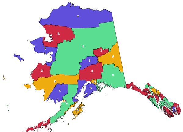
Fig. 24.1 Topological colors example
Parametrai
Užrašas |
Pavadinimas |
Tipas |
Aprašymas |
|---|---|---|---|
Įvesties sluoksnis |
|
[vektorius: poligonas] |
The input polygon layer |
Minimum number of colors |
|
[skaičius: sveikas skaičius] Default: 4 |
The minimum number of colors to assign. Minimum 1, maximum 1000. |
Minimum distance between features |
|
[skaičius: slankaus kablelio] Numatytas: 0.0 |
Prevent nearby (but non-touching) features from being assigned equal colors. Minimum 0.0. |
Balance color assignment |
|
[sąrašas] Numatytas: 0 |
Options are:
|
Colored |
|
[vektorius: poligonas] Numatytas: |
Nurodykite išvesties sluoksnį. Vienas iš:
Čia taipogi galima pakeisti failo koduotę. |
Išvestys
Užrašas |
Pavadinimas |
Tipas |
Aprašymas |
|---|---|---|---|
Colored |
|
[vektorius: poligonas] |
Polygon vector layer with an added |
Pythono kodas
Algorithm ID: qgis:topologicalcoloring
import processing
processing.run("algorithm_id", {parameter_dictionary})
algoritmo id rodomas, kai užvedate pelę virš algoritmo apdorojimo įrankinėje. parametrų žodynas teikia parametrų pavadinimus ir reikšmes. Daugiau informacijos apie tai, kaip vykdyti apdorojimo algoritmus Pythono konsolėje rasite skyriuje Using processing algorithms from the console.
24.1.2.14. Transfer annotations from main layer
Transfers all annotations from the main annotation layer in a project to a new annotation layer. Items placement can then be adjusted within the layer stack.
Parametrai
Užrašas |
Pavadinimas |
Tipas |
Aprašymas |
|---|---|---|---|
New layer name |
|
[tekstas] Default: ‚Annotations‘ |
Name of the annotations layer to create |
Išvestys
Užrašas |
Pavadinimas |
Tipas |
Aprašymas |
|---|---|---|---|
New layer name |
|
[layer] |
A layer with items from the main annotation layer |
Pythono kodas
Algorithm ID: native:transferannotationsfrommain
import processing
processing.run("algorithm_id", {parameter_dictionary})
algoritmo id rodomas, kai užvedate pelę virš algoritmo apdorojimo įrankinėje. parametrų žodynas teikia parametrų pavadinimus ir reikšmes. Daugiau informacijos apie tai, kaip vykdyti apdorojimo algoritmus Pythono konsolėje rasite skyriuje Using processing algorithms from the console.