Ważne
Tłumaczenie jest wysiłkiem społeczności QGISa przyłącz się. Ta strona jest obecnie przetłumaczona w 62.00%.
24.1.2. Kartografia
24.1.2.1. Align points to features
Calculates the rotation required to align point features with their nearest feature from another reference layer. A new field is added to the output layer which is filled with the angle (in degrees, clockwise) to the nearest reference feature.
Optionally, the output layer’s symbology can be set to automatically use the calculated rotation field to rotate marker symbols. If desired, a maximum distance to use when aligning points can be set, to avoid aligning isolated points to distant features.
Podpowiedź
This algorithm is designed for use cases like aligning building point symbols to follow the nearest road direction.
 Allows features in-place modification
of point features
Allows features in-place modification
of point features
Parametry
Etykieta |
Nazwa |
Typ |
Opis |
|---|---|---|---|
Warstwa wejściowa |
|
[vector: point] |
Point features to calculate the rotation for |
Warstwa referencyjna |
|
[vector: geometry] |
Layer to find the closest feature from for rotation calculation |
Maximum distance to consider Opcjonalne |
|
[numeric: double] Domyślnie: Nie ustawiono |
If no reference feature is found within this distance, no rotation is assigned to the point feature. |
Angle field name |
|
[ciąg tekstowy] Default: «rotation» |
Field in which to store the rotation value. |
Automatically apply symbology |
|
[wartość logiczna] Domyślnie: True |
Rotates the symbol marker of the features using the angle field value |
Aligned layer |
|
[vector: point] Domyślnie: |
Specify the rotated output vector layer. One of:
The file encoding can also be changed here. |
Wyniki
Etykieta |
Nazwa |
Typ |
Opis |
|---|---|---|---|
Aligned layer |
|
[vector: point] |
The point layer appended with a rotation field. If loaded to QGIS, it is applied by default the input layer symbology, with a data-defined rotation of its marker symbol. |
Kod pythona
ID algorytmu: native:angletonearest
import processing
processing.run("algorithm_id", {parameter_dictionary})
The algorithm id is displayed when you hover over the algorithm in the Processing Toolbox. The parameter dictionary provides the parameter NAMEs and values. See Using processing algorithms from the console for details on how to run processing algorithms from the Python console.
24.1.2.2. Combine style databases
Combines multiple QGIS style databases into a single style database. If items of the same type with the same name exist in different source databases these will be renamed to have unique names in the output combined database.
Zobacz także
Parametry
Etykieta |
Nazwa |
Typ |
Opis |
|---|---|---|---|
Input databases |
|
[file] [list] |
Files containing QGIS style items |
Objects to combine |
|
[enumeration] [list] |
Types of style items in the input databases you would like to put in the new database. These can be:
|
Output style database |
|
[plik] Domyślnie: |
Output
|
Wyniki
Etykieta |
Nazwa |
Typ |
Opis |
|---|---|---|---|
Color ramp count |
|
[numeric: integer] |
|
Label settings count |
|
[numeric: integer] |
|
Output style database |
|
[plik] |
Output |
Symbol count |
|
[numeric: integer] |
|
Text format count |
|
[numeric: integer] |
Kod pythona
ID algorytmu: native:combinestyles
import processing
processing.run("algorithm_id", {parameter_dictionary})
The algorithm id is displayed when you hover over the algorithm in the Processing Toolbox. The parameter dictionary provides the parameter NAMEs and values. See Using processing algorithms from the console for details on how to run processing algorithms from the Python console.
24.1.2.3. Create categorized renderer from styles
Sets a vector layer’s renderer to a categorized renderer using matching symbols from a style database. If no style file is specified, symbols from the user’s current symbol library are used instead.
A specified expression or field is used to create categories for the renderer. Each category is individually matched to the symbols which exist within the specified QGIS XML style database. Whenever a matching symbol name is found, the category’s symbol will be set to this matched symbol.
If desired, outputs can also be tables containing lists of the categories which could not be matched to symbols, and symbols which were not matched to categories.
Parametry
Etykieta |
Nazwa |
Typ |
Opis |
|---|---|---|---|
Warstwa wejściowa |
|
[vector: any] |
Vector layer to apply a categorized style to |
Categorize using expression |
|
[wyrażenie] |
Field or expression to categorize the features |
Style database (leave blank to use saved symbols) |
|
[plik] |
File ( |
Use case-sensitive match to symbol names |
|
[wartość logiczna] Domyślnie: False |
If True (checked), applies a case sensitive comparison between the categories and symbols names |
Ignore non-alphanumeric characters while matching |
|
[wartość logiczna] Domyślnie: False |
If True (checked), non-alphanumeric characters in the categories and symbols names will be ignored, allowing greater tolerance during the match. |
Non-matching categories Opcjonalne |
|
[vector: table] Default: |
Output table for categories which do not match any symbol in the database. One of:
The file encoding can also be changed here. |
Non-matching symbol names Opcjonalne |
|
[vector: table] Default: |
Output table for symbols from the provided style database which do not match any category. One of:
The file encoding can also be changed here. |
Wyniki
Etykieta |
Nazwa |
Typ |
Opis |
|---|---|---|---|
Non-matching categories |
|
[vector: table] |
Lists categories which could not be matched to any symbol in the provided style database |
Non-matching symbol names |
|
[vector: table] |
Lists symbols from the provided style database which could not match any category |
Categorized layer |
|
[same as input] |
The input vector layer with the categorized style applied. No new layer is output. |
Kod pythona
ID algorytmu: native:categorizeusingstyle
import processing
processing.run("algorithm_id", {parameter_dictionary})
The algorithm id is displayed when you hover over the algorithm in the Processing Toolbox. The parameter dictionary provides the parameter NAMEs and values. See Using processing algorithms from the console for details on how to run processing algorithms from the Python console.
24.1.2.4. Create style database from project
Extracts all style objects (symbols, color ramps, text formats and label settings) from a QGIS project.
The extracted symbols are saved to a QGIS style database (XML format),
which can be managed and imported via the Style Manager
dialog.
Zobacz także
Parametry
Etykieta |
Nazwa |
Typ |
Opis |
|---|---|---|---|
Input project (leave blank to use current) Opcjonalne |
|
[plik] |
A QGIS project file to extract the style items from |
Objects to extract |
|
[enumeration] [list] |
Types of style items in the input project you would like to put in the new database. These can be:
|
Output style database |
|
[plik] Domyślnie: |
Specify the output
|
Wyniki
Etykieta |
Nazwa |
Typ |
Opis |
|---|---|---|---|
Color ramp count |
|
[numeric: integer] |
Number of color ramps |
Label settings count |
|
[numeric: integer] |
Number of label settings |
Output style database |
|
[plik] |
Output |
Symbol count |
|
[numeric: integer] |
Number of symbols |
Text format count |
|
[numeric: integer] |
Number of text formats |
Kod pythona
ID algorytmu: native:stylefromproject
import processing
processing.run("algorithm_id", {parameter_dictionary})
The algorithm id is displayed when you hover over the algorithm in the Processing Toolbox. The parameter dictionary provides the parameter NAMEs and values. See Using processing algorithms from the console for details on how to run processing algorithms from the Python console.
24.1.2.5. Export atlas layout as image
Exports the atlas of a print layout as image files (e.g. PNG or JPEG images).
If a coverage layer is set, the selected layout’s atlas settings exposed in this algorithm will be overwritten. In this case, an empty filter or sort by expression will turn those settings off.
Parametry
Parametry podstawowe
Etykieta |
Nazwa |
Typ |
Opis |
|---|---|---|---|
Atlas layout |
|
[rozkład] |
Layout to export |
Coverage layer Opcjonalne |
|
[vector: geometry] |
Layer to use to generate the atlas |
Filter expression |
|
[wyrażenie] |
Expression to use to filter out atlas features |
Sort expression Opcjonalne |
|
[wyrażenie] |
Expression to use to sort the atlas features |
Reverse sort order |
|
[wartość logiczna] Domyślnie: False |
Determines if sorting should be inverted. Used when a sort expression is provided. |
Output filename expression |
|
[wyrażenie] Default: «output_»||@atlas_featurenumber |
Expression for use to generate filenames |
Output folder |
|
[folder] |
Destination folder where the images will be generated |
Parametry zaawansowane
Etykieta |
Nazwa |
Typ |
Opis |
|---|---|---|---|
Map layers to assign to unlocked map item(s) Opcjonalne |
|
[enumeration] [layer] |
Layers to display in the map item(s) whose contents are not locked |
Image format |
|
[wyliczenie] Domyślnie: png |
File format of the generated output(s). The list of available formats varies depending on OS and installed drivers. |
DPI Opcjonalne |
Domyślnie: Nie ustawiono |
[numeric: double] |
DPI of the output file(s). If not set, the value in the print layout settings will be used. |
Generate world file |
|
[wartość logiczna] Domyślnie: True |
Determines if a world file should be generated |
Export RDF metadata |
|
[wartość logiczna] Domyślnie: True |
Determines if RDF metadata (title, author, …) should be generated |
Włącz antyaliasing |
|
[wartość logiczna] Domyślnie: True |
Determines if antialiasing should be enabled |
Wyniki
Etykieta |
Nazwa |
Typ |
Opis |
|---|---|---|---|
Image file |
|
[plik] |
Image files generated by the atlas layout |
Kod pythona
ID algorytmu: native:atlaslayouttoimage
import processing
processing.run("algorithm_id", {parameter_dictionary})
The algorithm id is displayed when you hover over the algorithm in the Processing Toolbox. The parameter dictionary provides the parameter NAMEs and values. See Using processing algorithms from the console for details on how to run processing algorithms from the Python console.
24.1.2.6. Export atlas layout as PDF (multiple files)
Exports the atlas of a print layout to multiple PDF files.
If a coverage layer is set, the selected layout’s atlas settings exposed in this algorithm will be overwritten. In this case, an empty filter or sort by expression will turn those settings off.
Parametry
Parametry podstawowe
Etykieta |
Nazwa |
Typ |
Opis |
|---|---|---|---|
Atlas layout |
|
[rozkład] |
Layout to export |
Coverage layer Opcjonalne |
|
[vector: geometry] |
Layer to use to generate the atlas |
Filter expression |
|
[wyrażenie] |
Expression to use to filter out atlas features |
Sort expression Opcjonalne |
|
[wyrażenie] |
Expression to use to sort the atlas features |
Reverse sort order |
|
[wartość logiczna] Domyślnie: False |
Determines if sorting should be inverted. Used when a sort expression is provided. |
Output filename Opcjonalne |
|
[wyrażenie] |
Name pattern of the PDF output files. |
Output folder |
|
[folder] |
Destination folder for the output PDF files. |
Parametry zaawansowane
Etykieta |
Nazwa |
Typ |
Opis |
|---|---|---|---|
Map layers to assign to unlocked map item(s) Opcjonalne |
|
[enumeration] [layer] |
Layers to display in the map item(s) whose contents are not locked |
DPI Opcjonalne |
Domyślnie: Nie ustawiono |
[numeric: double] |
DPI of the output file(s). If not set, the value in the print layout settings will be used. |
Always export as vectors |
|
[wartość logiczna] Domyślnie: False |
Determines if vectorial data should be left as vectors |
Always export as raster |
|
[wartość logiczna] Domyślnie: False |
Forces all the items in the map to be rasterized.
This parameter takes precedence over the |
Append georeference information |
|
[wartość logiczna] Domyślnie: True |
Determines if a world file should be generated |
Export RDF metadata |
|
[wartość logiczna] Domyślnie: True |
Determines if RDF metadata (title, author, …) should be generated |
Disable tiled raster layer exports |
|
[wartość logiczna] Domyślnie: False |
Determines if raster should be tiled |
Simplify geometries to reduce output file size |
|
[wartość logiczna] Domyślnie: True |
Determines if geometries should be simplified to reduce output file size |
Text export |
|
[wyliczenie] Domyślnie: 0 |
Determines if text should be exported as path or text objects. Possible options are:
|
Image compression |
|
[wyliczenie] Domyślnie: 0 |
Determines compression level of the image and how suitable the file could be for printing outputs or post-production in external applications. Possible options are:
|
Wyniki
Etykieta |
Nazwa |
Typ |
Opis |
|---|---|---|---|
PDF file |
|
[plik] |
PDF file corresponding to the exported atlas layout |
Kod pythona
ID algorytmu: native:atlaslayouttomultiplepdf
import processing
processing.run("algorithm_id", {parameter_dictionary})
The algorithm id is displayed when you hover over the algorithm in the Processing Toolbox. The parameter dictionary provides the parameter NAMEs and values. See Using processing algorithms from the console for details on how to run processing algorithms from the Python console.
24.1.2.7. Export atlas layout as PDF (single file)
Exports the atlas of a print layout as a single PDF file.
If a coverage layer is set, the selected layout’s atlas settings exposed in this algorithm will be overwritten. In this case, an empty filter or sort by expression will turn those settings off.
Parametry
Parametry podstawowe
Etykieta |
Nazwa |
Typ |
Opis |
|---|---|---|---|
Atlas layout |
|
[rozkład] |
Layout to export |
Coverage layer Opcjonalne |
|
[vector: geometry] |
Layer to use to generate the atlas |
Filter expression |
|
[wyrażenie] |
Expression to use to filter out atlas features |
Sort expression Opcjonalne |
|
[wyrażenie] |
Expression to use to sort the atlas features |
Reverse sort order |
|
[wartość logiczna] Domyślnie: False |
Determines if sorting should be inverted. Used when a sort expression is provided. |
PDF file |
|
[plik] Domyślnie: [Zapisz do pliku tymczasowego] |
Name (including path) of the output file. One of:
|
Parametry zaawansowane
Etykieta |
Nazwa |
Typ |
Opis |
|---|---|---|---|
Map layers to assign to unlocked map item(s) Opcjonalne |
|
[enumeration] [layer] |
Layers to display in the map item(s) whose contents are not locked |
DPI Opcjonalne |
Domyślnie: Nie ustawiono |
[numeric: double] |
DPI of the output file(s). If not set, the value in the print layout settings will be used. |
Always export as vectors |
|
[wartość logiczna] Domyślnie: False |
Determines if vectorial data should be left as vectors |
Always export as raster |
|
[wartość logiczna] Domyślnie: False |
Forces all the items in the map to be rasterized.
This parameter takes precedence over the |
Append georeference information |
|
[wartość logiczna] Domyślnie: True |
Determines if a world file should be generated |
Export RDF metadata |
|
[wartość logiczna] Domyślnie: True |
Determines if RDF metadata (title, author, …) should be generated |
Disable tiled raster layer exports |
|
[wartość logiczna] Domyślnie: False |
Determines if raster should be tiled |
Simplify geometries to reduce output file size |
|
[wartość logiczna] Domyślnie: True |
Determines if geometries should be simplified to reduce output file size |
Text export |
|
[wyliczenie] Domyślnie: 0 |
Determines if text should be exported as path or text objects. Possible options are:
|
Image compression |
|
[wyliczenie] Domyślnie: 0 |
Determines compression level of the image and how suitable the file could be for printing outputs or post-production in external applications. Possible options are:
|
Wyniki
Etykieta |
Nazwa |
Typ |
Opis |
|---|---|---|---|
PDF file |
|
[plik] |
PDF file corresponding to the exported atlas layout |
Kod pythona
ID algorytmu: native:atlaslayouttopdf
import processing
processing.run("algorithm_id", {parameter_dictionary})
The algorithm id is displayed when you hover over the algorithm in the Processing Toolbox. The parameter dictionary provides the parameter NAMEs and values. See Using processing algorithms from the console for details on how to run processing algorithms from the Python console.
24.1.2.8. Export print layout as image
Exports a print layout as an image file (e.g. PNG or JPEG images)
Parametry
Parametry podstawowe
Etykieta |
Nazwa |
Typ |
Opis |
|---|---|---|---|
Print layout |
|
[rozkład] |
Layout to export |
Image file |
|
[plik] Domyślnie: [Zapisz do pliku tymczasowego] |
Name (including path) of the output file. One of:
|
Parametry zaawansowane
Etykieta |
Nazwa |
Typ |
Opis |
|---|---|---|---|
Map layers to assign to unlocked map item(s) Opcjonalne |
|
[enumeration] [layer] |
Layers to display in the map item(s) whose contents are not locked |
DPI Opcjonalne |
Domyślnie: Nie ustawiono |
[numeric: double] |
DPI of the output file(s). If not set, the value in the print layout settings will be used. |
Generate world file |
|
[wartość logiczna] Domyślnie: True |
Determines if a world file should be generated |
Export RDF metadata |
|
[wartość logiczna] Domyślnie: True |
Determines if RDF metadata (title, author, …) should be generated |
Włącz antyaliasing |
|
[wartość logiczna] Domyślnie: True |
Determines if antialiasing should be enabled |
Wyniki
Etykieta |
Nazwa |
Typ |
Opis |
|---|---|---|---|
Image file |
|
[plik] |
Image file corresponding to the exported print layout |
Kod pythona
ID algorytmu: native:printlayouttoimage
import processing
processing.run("algorithm_id", {parameter_dictionary})
The algorithm id is displayed when you hover over the algorithm in the Processing Toolbox. The parameter dictionary provides the parameter NAMEs and values. See Using processing algorithms from the console for details on how to run processing algorithms from the Python console.
24.1.2.9. Export print layout as PDF
Exports a print layout as a PDF file.
Parametry
Parametry podstawowe
Etykieta |
Nazwa |
Typ |
Opis |
|---|---|---|---|
Print Layout |
|
[rozkład] |
Layout to export |
PDF file |
|
[plik] Domyślnie: [Zapisz do pliku tymczasowego] |
Name (including path) of the output file. One of:
|
Parametry zaawansowane
Etykieta |
Nazwa |
Typ |
Opis |
|---|---|---|---|
Map layers to assign to unlocked map item(s) Opcjonalne |
|
[enumeration] [layer] |
Layers to display in the map item(s) whose contents are not locked |
DPI Opcjonalne |
Domyślnie: Nie ustawiono |
[numeric: double] |
DPI of the output file(s). If not set, the value in the print layout settings will be used. |
Always export as vectors |
|
[wartość logiczna] Domyślnie: False |
Determines if vectorial data should be left as vectors |
Always export as raster |
|
[wartość logiczna] Domyślnie: False |
Forces all the items in the map to be rasterized.
This parameter takes precedence over the |
Append georeference information |
|
[wartość logiczna] Domyślnie: True |
Determines if a world file should be generated |
Export RDF metadata |
|
[wartość logiczna] Domyślnie: True |
Determines if RDF metadata (title, author, …) should be generated |
Disable tiled raster layer exports |
|
[wartość logiczna] Domyślnie: False |
Determines if raster should be tiled |
Simplify geometries to reduce output file size |
|
[wartość logiczna] Domyślnie: True |
Determines if geometries should be simplified to reduce output file size |
Text export |
|
[wyliczenie] Domyślnie: 0 |
Determines if text should be exported as path or text objects. Possible options are:
|
Image compression |
|
[wyliczenie] Domyślnie: 0 |
Determines compression level of the image and how suitable the file could be for printing outputs or post-production in external applications. Possible options are:
|
Export layers as separate PDF files |
|
[wartość logiczna] Domyślnie: False |
If True, then a separate PDF file will be created per layer per map item in the layout. Additionally, separate PDF files may be created for other complex layout items, resulting in a set of PDF files which contain logical atomic components of the layout. |
Wyniki
Etykieta |
Nazwa |
Typ |
Opis |
|---|---|---|---|
PDF file |
|
[plik] |
PDF file(s) corresponding to the exported print layout |
Kod pythona
ID algorytmu: native:printlayouttopdf
import processing
processing.run("algorithm_id", {parameter_dictionary})
The algorithm id is displayed when you hover over the algorithm in the Processing Toolbox. The parameter dictionary provides the parameter NAMEs and values. See Using processing algorithms from the console for details on how to run processing algorithms from the Python console.
24.1.2.10. Extract labels
Extracts label information from a rendered map at a given extent and scale.
If a map theme is provided, the rendered map will match the visibility and symbology of that theme. If left blank, all visible layers from the project will be used. Extracted label information include: position (served as point geometries), the associated layer name and feature ID, label text, rotation (in degree, clockwise), multiline alignment, and font details.
Ostrzeżenie
This algorithm drops existing primary keys or FID values and regenerates them in output layers.
Parametry
Parametry podstawowe
Etykieta |
Nazwa |
Typ |
Opis |
|---|---|---|---|
Map extent |
|
[zasięg] |
Extent of the map to extract the labels from Available methods are:
|
Map scale |
|
[skala] |
Extracted labels will be rendered using their properties set at this scale. |
Map theme Opcjonalne |
|
[maptheme] |
A map theme displaying the layers to extract the labels from. If unset, labels of the currently visible layers are extracted. |
Include unplaced labels |
|
[wartość logiczna] Domyślnie: True |
Specify whether all overlapping labels should be extracted, including the conflicting (thus unplaced) ones. |
Extracted labels |
|
[vector: point] Default: |
Specify the output vector layer for the extent(s). One of:
The file encoding can also be changed here. |
Parametry zaawansowane
Etykieta |
Nazwa |
Typ |
Opis |
|---|---|---|---|
Map resolution (in DPI) Opcjonalne |
Domyślnie: 96.0 |
[numeric: double] |
Wyniki
Etykieta |
Nazwa |
Typ |
Opis |
|---|---|---|---|
Extracted labels |
|
[vector: point] |
Point vector layer representing the fetched labels. Each feature has attributes identifying its source (layer, feature ID) and the assigned labeling properties (text, font, size, rotation, …). A default style with labeling and null symbol is also applied to the layer. Ostrzeżenie Because some of the generated fields have name with more than
10 characters, using the ESRI shapefile format ( |
Kod pythona
ID algorytmu: native:extractlabels
import processing
processing.run("algorithm_id", {parameter_dictionary})
The algorithm id is displayed when you hover over the algorithm in the Processing Toolbox. The parameter dictionary provides the parameter NAMEs and values. See Using processing algorithms from the console for details on how to run processing algorithms from the Python console.
24.1.2.11. Zasięg mapy z wydruku jako warstwa
Algorytm tworzy warstwę poligonową zawierającą zasięg mapy (lub map) z układu wydruku, z atrybutami określającymi rozmiar mapy (w jednostkach układu, na przykład w jednostkach :ref:`mapy referencyjnej <reference_map> ` ), skalę i obrót.
Jeśli parametr mapy zostanie określony, eksportowany będzie tylko pasujący zasięg mapy. Jeśli nie zostanie określony, wyeksportowane zostaną wszystkie zasięgi map z układu.
Opcjonalnie można określić konkretny wyjściowy układ współrzędnych. Jeśli nie zostanie określony, zostanie użyty oryginalny układ współrzędnych mapy.
Parametry
Parametry podstawowe
Etykieta |
Nazwa |
Typ |
Opis |
|---|---|---|---|
Print layout |
|
[wyliczenie] |
Układ wydruku w bieżącym projekcie |
Mapa Opcjonalne |
|
[wyliczenie] Domyślnie: Wszystkie obiekty mapowe |
The map item(s) whose information you want to extract. If none is provided then all the map items are processed. |
Zasięg |
|
[vector: polygon] Default: |
Specify the output vector layer for the extent(s). One of:
The file encoding can also be changed here. |
Parametry zaawansowane
Etykieta |
Nazwa |
Typ |
Opis |
|---|---|---|---|
Nadpisz układ współrzędnych Opcjonalne |
|
[układ współrzędnych] Domyślnie: Układ współrzędnych układu wydruku |
Select the CRS for the layer in which the information will be reported. |
Wyniki
Etykieta |
Nazwa |
Typ |
Opis |
|---|---|---|---|
Map height |
|
[numeric: double] |
|
Zasięg |
|
[vector: polygon] |
Output polygon vector layer containing extents of all the input layout map item(s) |
Map rotation |
|
[numeric: double] |
|
Map scale |
|
[numeric: double] |
|
Map width |
|
[numeric: double] |
Kod pythona
ID algorytmu: native:printlayoutmapextenttolayer
import processing
processing.run("algorithm_id", {parameter_dictionary})
The algorithm id is displayed when you hover over the algorithm in the Processing Toolbox. The parameter dictionary provides the parameter NAMEs and values. See Using processing algorithms from the console for details on how to run processing algorithms from the Python console.
24.1.2.12. Ustaw styl warstwy
Stosuje styl do warstwy. Styl musi być zdefiniowany jako plik QML.
No new output are created: the style is immediately assigned to the layer.
Parametry
Etykieta |
Nazwa |
Typ |
Opis |
|---|---|---|---|
Warstwa wejściowa |
|
[warstwa] |
Warstwa wejściowa, dla której chcesz przypisać styl |
Plik stylu |
|
[plik] |
Pełna ścieżka do pliku |
Wyniki
Etykieta |
Nazwa |
Typ |
Opis |
|---|---|---|---|
|
[same as input] |
The input layer with the new style assigned. No new layer is created. |
Kod pythona
ID algorytmu: native:setlayerstyle
import processing
processing.run("algorithm_id", {parameter_dictionary})
The algorithm id is displayed when you hover over the algorithm in the Processing Toolbox. The parameter dictionary provides the parameter NAMEs and values. See Using processing algorithms from the console for details on how to run processing algorithms from the Python console.
24.1.2.13. Kolorowanie topologiczne
Algorytm przypisuje indeks koloru do obiektów poligonowych w taki sposób, że żadne sąsiadujące poligony nie mają tego samego indeksu koloru, minimalizując jednocześnie liczbę wymaganych kolorów.
Algorytm umożliwia wybór metody przypisywania kolorów.
W razie potrzeby można określić minimalną liczbę kolorów. Indeks koloru jest zapisywany w nowym atrybucie o nazwie color_id.
The following example shows the algorithm with four different colors chosen; as you can see each color class has the same amount of features.
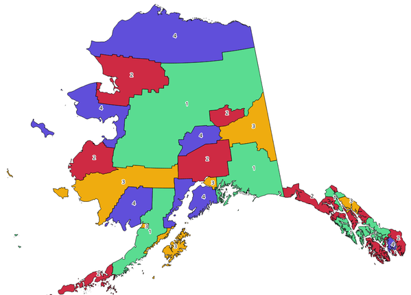
Rys. 24.1 Przykład kolorowania topologicznego
Parametry
Etykieta |
Nazwa |
Typ |
Opis |
|---|---|---|---|
Warstwa wejściowa |
|
[vector: polygon] |
Wejściowa warstwa poligonowa |
Minimalna liczba kolorów |
|
[numeric: integer] Domyślnie: 4 |
Minimalna liczba kolorów do przypisania. Minimum 1, maksimum 1000. |
Minimalna odległość między obiektami |
|
[numeric: double] Domyślnie: 0.0 |
Prevent nearby (but non-touching) features from being assigned equal colors. Minimum 0.0. |
Balansuj przypisywanie kolorów |
|
[wyliczenie] Domyślnie: 0 |
Options are:
|
Pokolorowane |
|
[vector: polygon] Default: |
Specify the output layer. One of:
The file encoding can also be changed here. |
Wyniki
Etykieta |
Nazwa |
Typ |
Opis |
|---|---|---|---|
Pokolorowane |
|
[vector: polygon] |
Polygon vector layer with an added |
Kod pythona
ID algorytmu: qgis:topologicalcoloring
import processing
processing.run("algorithm_id", {parameter_dictionary})
The algorithm id is displayed when you hover over the algorithm in the Processing Toolbox. The parameter dictionary provides the parameter NAMEs and values. See Using processing algorithms from the console for details on how to run processing algorithms from the Python console.
24.1.2.14. Przenieś adnotacje z warstwy głównej
Algorytm przenosi wszystkie adnotacje z głównej warstwy adnotacji w projekcie do nowej warstwy adnotacji.
Parametry
Etykieta |
Nazwa |
Typ |
Opis |
|---|---|---|---|
Nazwa nowej warstwy |
|
[ciąg tekstowy] Domyślnie: «Przypisy» |
Nazwa warstwy z adnotacjami, która ma zostać utworzona |
Wyniki
Etykieta |
Nazwa |
Typ |
Opis |
|---|---|---|---|
Nazwa nowej warstwy |
|
[warstwa] |
Warstwa z obiektami z głównej warstwy adnotacji |
Kod pythona
ID algorytmu: native:transferannotationsfrommain
import processing
processing.run("algorithm_id", {parameter_dictionary})
The algorithm id is displayed when you hover over the algorithm in the Processing Toolbox. The parameter dictionary provides the parameter NAMEs and values. See Using processing algorithms from the console for details on how to run processing algorithms from the Python console.