Ważne
Tłumaczenie jest wysiłkiem społeczności QGISa przyłącz się. Ta strona jest obecnie przetłumaczona w 63.10%.
24.1.14. Point Cloud Extraction
Informacja
These algorithms are only available if QGIS uses the PDAL library version 2.5.0 or newer.
24.1.14.1. Granica
Exports a polygon file containing point cloud layer boundary. It may contain holes and it may be a multi-part polygon.
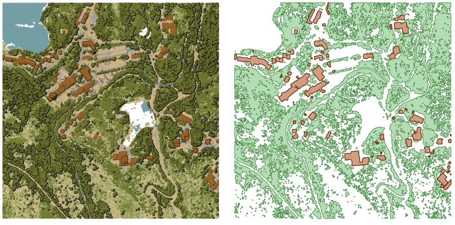
Rys. 24.16 Extracting high vegetation and building polygons from an input point cloud layer
Parametry
Parametry podstawowe
Etykieta |
Nazwa |
Typ |
Opis |
|---|---|---|---|
Warstwa wejściowa |
|
[point cloud] |
Input point cloud layer to calculate boundary for |
Resolution of cells used to calculate boundary Opcjonalne |
|
[numeric: double] |
Resolution of cells used to calculate boundary |
Minimal number of points in a cell to consider cell occupied Opcjonalne |
|
[numeric: integer] |
Minimal number of points in a cell to consider cell occupied |
Granica |
|
[vector: polygon] Domyślnie: |
Specify the point cloud file to use as output. One of:
|
Parametry zaawansowane
Etykieta |
Nazwa |
Typ |
Opis |
|---|---|---|---|
Filter expression Opcjonalne |
|
[wyrażenie] |
A PDAL expression for selecting a subset of features in the point cloud data |
Cropping extent Opcjonalne |
|
[zasięg] |
A map extent for selecting a subset of features in the point cloud data Available methods are:
|
Wyniki
Etykieta |
Nazwa |
Typ |
Opis |
|---|---|---|---|
Granica |
|
[vector: polygon] |
Output polygon vector layer with the point cloud boundary.
Currently supported format is |
Kod pythona
ID algorytmu: pdal:boundary
import processing
processing.run("algorithm_id", {parameter_dictionary})
The algorithm id is displayed when you hover over the algorithm in the Processing Toolbox. The parameter dictionary provides the parameter NAMEs and values. See Using processing algorithms from the console for details on how to run processing algorithms from the Python console.
24.1.14.2. Gęstość
Exports a raster file based on the number of points within each raster cell - useful for quality checking of point cloud datasets.
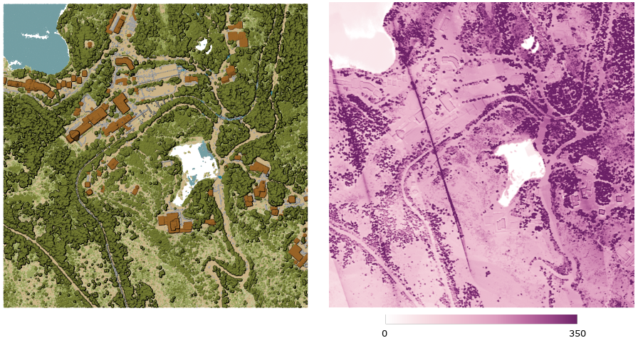
Rys. 24.17 Point density (number of points per 2x2 m) as a raster
Parametry
Parametry podstawowe
Etykieta |
Nazwa |
Typ |
Opis |
|---|---|---|---|
Warstwa wejściowa |
|
[point cloud] |
Input point cloud layer to export |
Resolution of the density raster |
|
[numeric: double] Domyślnie: 1.0 |
Cell size of the output raster |
Tile size for parallel runs |
|
[numeric: integer] Domyślnie: 1000 |
Size of the tiles to split the data into for parallel runs |
Gęstość |
|
[raster] Domyślnie: |
Specify the raster file to export the data to. One of:
|
Parametry zaawansowane
Etykieta |
Nazwa |
Typ |
Opis |
|---|---|---|---|
Filter expression Opcjonalne |
|
[wyrażenie] |
A PDAL expression for selecting a subset of features in the point cloud data |
Cropping extent Opcjonalne |
|
[zasięg] |
A map extent for selecting a subset of features in the point cloud data Available methods are:
|
X origin of a tile for parallel runs Opcjonalne |
|
[numeric: double] |
|
Y origin of a tile for parallel runs Opcjonalne |
|
[numeric: double] |
Wyniki
Etykieta |
Nazwa |
Typ |
Opis |
|---|---|---|---|
Gęstość |
|
[raster] |
Output raster layer with number of points within each cell.
Currently supported format is |
Kod pythona
ID algorytmu: pdal:density
import processing
processing.run("algorithm_id", {parameter_dictionary})
The algorithm id is displayed when you hover over the algorithm in the Processing Toolbox. The parameter dictionary provides the parameter NAMEs and values. See Using processing algorithms from the console for details on how to run processing algorithms from the Python console.
24.1.14.3. Filtr
Extracts point from the input point cloud which match PDAL expression and/or are inside of a cropping rectangle.
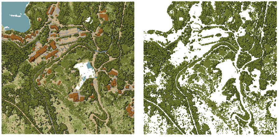
Rys. 24.18 Filtering of high vegetation class from an input point cloud layer
Parametry
Etykieta |
Nazwa |
Typ |
Opis |
|---|---|---|---|
Warstwa wejściowa |
|
[point cloud] |
Input point cloud layer to export |
Filter expression Opcjonalne |
|
[wyrażenie] |
A PDAL expression for selecting a subset of features in the point cloud data |
Cropping extent Opcjonalne |
|
[zasięg] |
A map extent for selecting a subset of features in the point cloud data Available methods are:
|
Przefiltrowane |
|
[point cloud] Domyślnie: |
Specify the point cloud file to export the data to. One of:
|
Wyniki
Etykieta |
Nazwa |
Typ |
Opis |
|---|---|---|---|
Przefiltrowane |
|
[point cloud] |
Output point cloud layer with the filtered features of the input point cloud layer.
Currently supported formats are |
Kod pythona
ID algorytmu: pdal:filter
import processing
processing.run("algorithm_id", {parameter_dictionary})
The algorithm id is displayed when you hover over the algorithm in the Processing Toolbox. The parameter dictionary provides the parameter NAMEs and values. See Using processing algorithms from the console for details on how to run processing algorithms from the Python console.