Ważne
Tłumaczenie jest wysiłkiem społeczności QGISa przyłącz się. Ta strona jest obecnie przetłumaczona w 68.50%.
24.1.13. Point Cloud Data Management
Informacja
These algorithms are only available if QGIS uses the PDAL library version 2.5.0 or newer.
24.1.13.1. Assign projection
Assigns a Coordinate Reference System to a point cloud layer, if it is missing or wrong. A new layer is created.
Zobacz także
Parametry
Etykieta |
Nazwa |
Typ |
Opis |
|---|---|---|---|
Warstwa wejściowa |
|
[point cloud] |
Input point cloud layer to assign a CRS to |
Desired CRS |
|
[układ współrzędnych] |
The CRS to apply to the layer |
Warstwa wynikowa |
|
[point cloud] Domyślnie: |
Specify the point cloud file to use as output. One of:
|
Wyniki
Etykieta |
Nazwa |
Typ |
Opis |
|---|---|---|---|
Przekonwertowany |
|
[point cloud] |
Output point cloud layer with a new CRS.
Currently supported formats are |
Kod pythona
ID algorytmu: pdal:assignprojection
import processing
processing.run("algorithm_id", {parameter_dictionary})
The algorithm id is displayed when you hover over the algorithm in the Processing Toolbox. The parameter dictionary provides the parameter NAMEs and values. See Using processing algorithms from the console for details on how to run processing algorithms from the Python console.
24.1.13.2. Build virtual point cloud (VPC)
Creates a virtual point cloud (VPC) from input point cloud data.
If you leave the optional parameters unchecked, the VPC file will be built very quickly as the algorithm will only read metadata of input files. With any of the optional parameters set, the algorithm will read all points which can take some time.
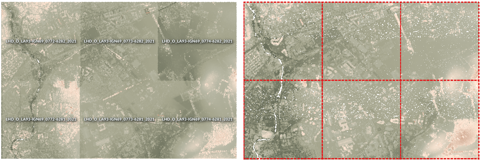
Rys. 24.13 Generating Virtual Point Cloud with overview from a set of point cloud tiles
Zobacz także
Parametry
Etykieta |
Nazwa |
Typ |
Opis |
|---|---|---|---|
Warstwy wejściowe |
|
[point cloud] [list] |
Input point cloud layers to combine inside a virtual point cloud layer |
Calculate boundary polygon |
|
[wartość logiczna] Domyślnie: False |
Set to True to show the exact boundaries of data (rather than just rectangular extent) |
Calculate statistics |
|
[wartość logiczna] Domyślnie: False |
Set to True to understand ranges of values of the various attributes |
Build overview point cloud |
|
[wartość logiczna] Domyślnie: False |
Generates a single “thinned” point cloud of all the input data (using only every 1000th point from original data). The overview point cloud will be created next to the VPC file -
for example, for |
Virtual point cloud |
|
[point cloud] Domyślnie: |
Specify the point cloud file to build the data into. One of:
|
Wyniki
Etykieta |
Nazwa |
Typ |
Opis |
|---|---|---|---|
Virtual point cloud |
|
[raster] |
Output point cloud layer combining all the input data, as a virtual file. |
Kod pythona
ID algorytmu: pdal:virtualpointcloud
import processing
processing.run("algorithm_id", {parameter_dictionary})
The algorithm id is displayed when you hover over the algorithm in the Processing Toolbox. The parameter dictionary provides the parameter NAMEs and values. See Using processing algorithms from the console for details on how to run processing algorithms from the Python console.
24.1.13.3. Przytnij
Clips a point cloud layer by a polygon layer so that the resulting point cloud contains only points within the polygons.
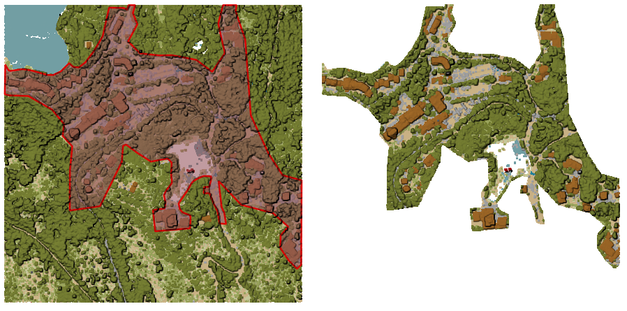
Rys. 24.14 Clipping an input point cloud layer with a polygon coverage
Parametry
Parametry podstawowe
Etykieta |
Nazwa |
Typ |
Opis |
|---|---|---|---|
Warstwa wejściowa |
|
[point cloud] |
Input point cloud layer to clip |
Clipping polygons |
|
[vector: polygon] |
Polygon vector layer to use as coverage for clipping the points |
Przycięte |
|
[point cloud] Domyślnie: |
Specify the point cloud file to export the clipped points to. One of:
|
Parametry zaawansowane
Etykieta |
Nazwa |
Typ |
Opis |
|---|---|---|---|
Filter expression Opcjonalne |
|
[wyrażenie] |
A PDAL expression for selecting a subset of features in the point cloud data |
Cropping extent Opcjonalne |
|
[zasięg] |
A map extent for selecting a subset of features in the point cloud data Available methods are:
|
Wyniki
Etykieta |
Nazwa |
Typ |
Opis |
|---|---|---|---|
Przycięte |
|
[point cloud] |
Output point cloud whose features are the points within the coverage polygon layer. |
Kod pythona
ID algorytmu: pdal:clip
import processing
processing.run("algorithm_id", {parameter_dictionary})
The algorithm id is displayed when you hover over the algorithm in the Processing Toolbox. The parameter dictionary provides the parameter NAMEs and values. See Using processing algorithms from the console for details on how to run processing algorithms from the Python console.
24.1.13.4. Create COPC
Creates the index for all the input point cloud files in a batch mode.
Parametry
Etykieta |
Nazwa |
Typ |
Opis |
|---|---|---|---|
Warstwy wejściowe |
|
[point cloud] [list] |
Input point cloud layers to create an index for |
Katalog wynikowy Opcjonalne |
|
[folder] Default: |
Specify the folder to create the new files in. One of:
|
Wyniki
Etykieta |
Nazwa |
Typ |
Opis |
|---|---|---|---|
Katalog wynikowy |
|
[folder] |
Output folder containing point cloud layers with accompanying COPC index files. |
Kod pythona
ID algorytmu: pdal:createcopc
import processing
processing.run("algorithm_id", {parameter_dictionary})
The algorithm id is displayed when you hover over the algorithm in the Processing Toolbox. The parameter dictionary provides the parameter NAMEs and values. See Using processing algorithms from the console for details on how to run processing algorithms from the Python console.
24.1.13.5. Informacja
Outputs basic metadata from an input point cloud file.
Example of output information:
LAS           1.4
point format  6
count         56736130
scale         0.001 0.001 0.001
offset        431749.999 5440919.999 968.898
extent        431250 5440420 424.266
              432249.999 5441419.999 1513.531
crs           ETRS89 / UTM zone 34N (N-E) (EPSG:3046)  (vertical CRS missing!)
units         horizontal=metre  vertical=unknown

Attributes:
- X floating 8
- Y floating 8
- Z floating 8
- Intensity unsigned 2
- ReturnNumber unsigned 1
- NumberOfReturns unsigned 1
- ScanDirectionFlag unsigned 1
- EdgeOfFlightLine unsigned 1
- Classification unsigned 1
- ScanAngleRank floating 4
- UserData unsigned 1
- PointSourceId unsigned 2
- GpsTime floating 8
- ScanChannel unsigned 1
- ClassFlags unsigned 1
Parametry
Etykieta |
Nazwa |
Typ |
Opis |
|---|---|---|---|
Warstwa wejściowa |
|
[point cloud] |
Input point cloud layer to extract metadata information from |
Layer information |
|
[plik] Domyślnie: |
Specify the file to store the metadata information. One of:
|
Wyniki
Etykieta |
Nazwa |
Typ |
Opis |
|---|---|---|---|
Layer information |
|
[html] |
|
Kod pythona
ID algorytmu: pdal:info
import processing
processing.run("algorithm_id", {parameter_dictionary})
The algorithm id is displayed when you hover over the algorithm in the Processing Toolbox. The parameter dictionary provides the parameter NAMEs and values. See Using processing algorithms from the console for details on how to run processing algorithms from the Python console.
24.1.13.6. Złącz
Merges multiple point cloud files into a single one.
Zobacz także
Parametry
Parametry podstawowe
Etykieta |
Nazwa |
Typ |
Opis |
|---|---|---|---|
Warstwy wejściowe |
|
[point cloud] [list] |
Input point cloud layers to merge into a single one |
Złączone |
|
[point cloud] Domyślnie: |
Specify the output point cloud merging input files. One of:
|
Parametry zaawansowane
Etykieta |
Nazwa |
Typ |
Opis |
|---|---|---|---|
Filter expression Opcjonalne |
|
[wyrażenie] |
A PDAL expression for selecting a subset of features in the point cloud data |
Cropping extent Opcjonalne |
|
[zasięg] |
A map extent for selecting a subset of features in the point cloud data Available methods are:
|
Wyniki
Etykieta |
Nazwa |
Typ |
Opis |
|---|---|---|---|
Złączone |
|
[point cloud] |
Output point cloud layer merging all the input files. |
Kod pythona
ID algorytmu: pdal:merge
import processing
processing.run("algorithm_id", {parameter_dictionary})
The algorithm id is displayed when you hover over the algorithm in the Processing Toolbox. The parameter dictionary provides the parameter NAMEs and values. See Using processing algorithms from the console for details on how to run processing algorithms from the Python console.
24.1.13.7. Reproject
Reprojects a point cloud to a different Coordinate Reference System (CRS).
Zobacz także
Parametry
Etykieta |
Nazwa |
Typ |
Opis |
|---|---|---|---|
Warstwa wejściowa |
|
[point cloud] |
Input point cloud layer to reproject to a different CRS |
Target CRS |
|
[układ współrzędnych] |
The CRS to apply to the layer |
Reprojected |
|
[point cloud] Domyślnie: |
Specify the reprojected point cloud file. One of:
|
Parametry zaawansowane
Etykieta |
Nazwa |
Typ |
Opis |
|---|---|---|---|
Coordinate operation Opcjonalne |
|
[datum] |
The datum transformation to use to reproject the data between the origin and target systems. |
Wyniki
Etykieta |
Nazwa |
Typ |
Opis |
|---|---|---|---|
REPROJECTED |
|
[point cloud] |
Output point cloud layer in the target CRS. |
Kod pythona
ID algorytmu: pdal:reproject
import processing
processing.run("algorithm_id", {parameter_dictionary})
The algorithm id is displayed when you hover over the algorithm in the Processing Toolbox. The parameter dictionary provides the parameter NAMEs and values. See Using processing algorithms from the console for details on how to run processing algorithms from the Python console.
24.1.13.8. Thin (by sampling radius)
Creates a thinned version of the point cloud by performing sampling by distance point (reduces the number of points within a certain radius).
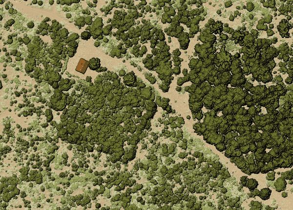
Rys. 24.15 Thining point cloud (by sampling radius)
Zobacz także
Parametry
Parametry podstawowe
Etykieta |
Nazwa |
Typ |
Opis |
|---|---|---|---|
Warstwa wejściowa |
|
[point cloud] |
Input point cloud layer to create a thinned version from |
Sampling radius (in map units) |
|
[numeric: double] Domyślnie: 1.0 |
Distance within which points are sampled to a unique point |
Thinned (by radius) |
|
[point cloud] Domyślnie: |
Specify the output point cloud with reduced points. One of:
|
Parametry zaawansowane
Etykieta |
Nazwa |
Typ |
Opis |
|---|---|---|---|
Filter expression Opcjonalne |
|
[wyrażenie] |
A PDAL expression for selecting a subset of features in the point cloud data |
Cropping extent Opcjonalne |
|
[zasięg] |
A map extent for selecting a subset of features in the point cloud data Available methods are:
|
Wyniki
Etykieta |
Nazwa |
Typ |
Opis |
|---|---|---|---|
Thinned (by radius) |
|
[point cloud] |
Output point cloud layer with reduced points. |
Kod pythona
ID algorytmu: pdal:thinbyradius
import processing
processing.run("algorithm_id", {parameter_dictionary})
The algorithm id is displayed when you hover over the algorithm in the Processing Toolbox. The parameter dictionary provides the parameter NAMEs and values. See Using processing algorithms from the console for details on how to run processing algorithms from the Python console.
24.1.13.9. Thin (by skipping points)
Creates a thinned version of the point cloud by keeping only every N-th point (reduces the number of points by skipping nearby points).
Zobacz także
Parametry
Parametry podstawowe
Etykieta |
Nazwa |
Typ |
Opis |
|---|---|---|---|
Warstwa wejściowa |
|
[point cloud] |
Input point cloud layer to create a thinned version from |
Number of points to skip |
|
[numeric: integer] Domyślnie: 1 |
Keep only every N-th point in the input layer |
Thinned (by decimation) |
|
[point cloud] Domyślnie: |
Specify the output point cloud with reduced points. One of:
|
Parametry zaawansowane
Etykieta |
Nazwa |
Typ |
Opis |
|---|---|---|---|
Filter expression Opcjonalne |
|
[wyrażenie] |
A PDAL expression for selecting a subset of features in the point cloud data |
Cropping extent Opcjonalne |
|
[zasięg] |
A map extent for selecting a subset of features in the point cloud data Available methods are:
|
Wyniki
Etykieta |
Nazwa |
Typ |
Opis |
|---|---|---|---|
Thinned (by decimation) |
|
[point cloud] |
Output point cloud layer with reduced points. |
Kod pythona
ID algorytmu: pdal:thinbydecimate
import processing
processing.run("algorithm_id", {parameter_dictionary})
The algorithm id is displayed when you hover over the algorithm in the Processing Toolbox. The parameter dictionary provides the parameter NAMEs and values. See Using processing algorithms from the console for details on how to run processing algorithms from the Python console.
24.1.13.10. Kafel
Creates tiles from input point cloud files, recommended for best performance (in display or analysis) with such datasets in QGIS.
Zobacz także
Parametry
Parametry podstawowe
Etykieta |
Nazwa |
Typ |
Opis |
|---|---|---|---|
Warstwy wejściowe |
|
[point cloud] [list] |
Input point cloud layers to create tiles from |
Tile length |
|
[numeric: double] Domyślnie: 1000.0 |
Size of the edge of each generated tile |
Katalog wynikowy |
|
[folder] Domyślnie: |
Specify the folder to store the generated tiles. One of:
|
Parametry zaawansowane
Etykieta |
Nazwa |
Typ |
Opis |
|---|---|---|---|
Assign CRS Opcjonalne |
|
[układ współrzędnych] |
The CRS to apply to the layer |
Wyniki
Etykieta |
Nazwa |
Typ |
Opis |
|---|---|---|---|
Katalog wynikowy |
|
[folder] |
Output folder containing the tiles generated from input files. |
Kod pythona
ID algorytmu: pdal:tile
import processing
processing.run("algorithm_id", {parameter_dictionary})
The algorithm id is displayed when you hover over the algorithm in the Processing Toolbox. The parameter dictionary provides the parameter NAMEs and values. See Using processing algorithms from the console for details on how to run processing algorithms from the Python console.