Важно
Перевод - это работа сообщества : ссылка:Вы можете присоединиться. Эта страница в настоящее время переводится |прогресс перевода|.
24.1.14. Point Cloud Extraction
Примечание
These algorithms are only available if QGIS uses the PDAL library version 2.5.0 or newer.
24.1.14.1. Boundary
Exports a polygon file containing point cloud layer boundary. It may contain holes and it may be a multi-part polygon.
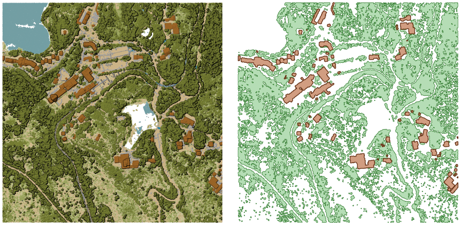
Рис. 24.16 Extracting high vegetation and building polygons from an input point cloud layer
Параметры
Basic parameters
Ярлык |
Имя |
Тип |
Описание |
|---|---|---|---|
Исходный слой |
|
[point cloud] |
Input point cloud layer to calculate boundary for |
Resolution of cells used to calculate boundary Optional |
|
[numeric: double] |
Resolution of cells used to calculate boundary |
Minimal number of points in a cell to consider cell occupied Optional |
|
[numeric: integer] |
Minimal number of points in a cell to consider cell occupied |
Boundary |
|
[vector: polygon] По умолчанию: |
Specify the point cloud file to use as output. One of:
|
Advanced parameters
Ярлык |
Имя |
Тип |
Описание |
|---|---|---|---|
Filter expression Optional |
|
[expression] |
A PDAL expression for selecting a subset of features in the point cloud data |
Cropping extent Optional |
|
[extent] |
A map extent for selecting a subset of features in the point cloud data Available methods are:
|
Результаты
Ярлык |
Имя |
Тип |
Описание |
|---|---|---|---|
Boundary |
|
[vector: polygon] |
Output polygon vector layer with the point cloud boundary.
Currently supported format is |
Код на Python
Algorithm ID: pdal:boundary
import processing
processing.run("algorithm_id", {parameter_dictionary})
ID алгоритма отображается при наведении мыши на алгоритм в Инструментах анализа. Словарь parameter dictionary содержит ключи параметров и их значения. См. Изпользование алгоритмов геообработки в консоли для детального описания того, как запускать алгоритмы анализа из консоли Python.
24.1.14.2. Density
Exports a raster file based on the number of points within each raster cell - useful for quality checking of point cloud datasets.
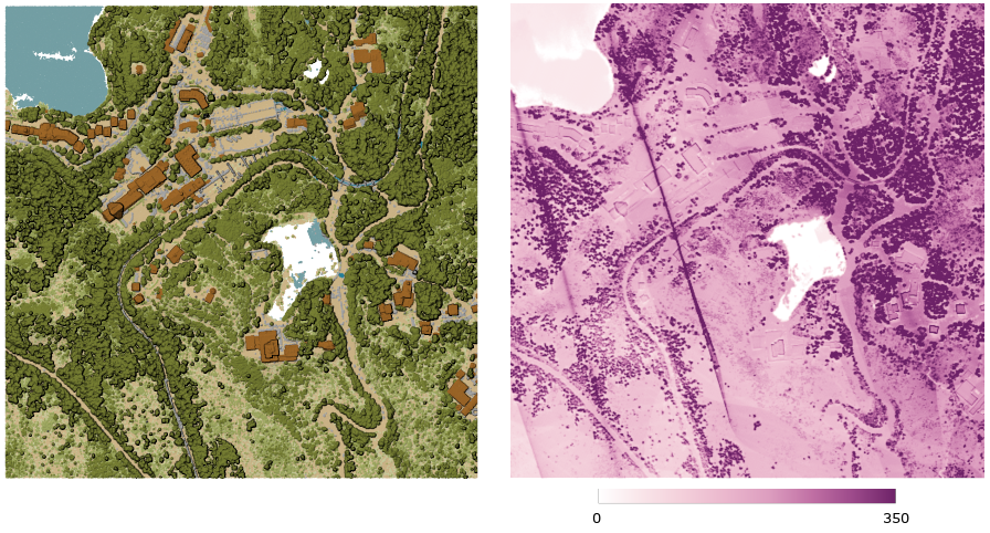
Рис. 24.17 Point density (number of points per 2x2 m) as a raster
Параметры
Basic parameters
Ярлык |
Имя |
Тип |
Описание |
|---|---|---|---|
Исходный слой |
|
[point cloud] |
Input point cloud layer to export |
Resolution of the density raster |
|
[numeric: double] Default: 1.0 |
Cell size of the output raster |
Tile size for parallel runs |
|
[numeric: integer] Default: 1000 |
Size of the tiles to split the data into for parallel runs |
Density |
|
[растр] По умолчанию: |
Specify the raster file to export the data to. One of:
|
Advanced parameters
Ярлык |
Имя |
Тип |
Описание |
|---|---|---|---|
Filter expression Optional |
|
[expression] |
A PDAL expression for selecting a subset of features in the point cloud data |
Cropping extent Optional |
|
[extent] |
A map extent for selecting a subset of features in the point cloud data Available methods are:
|
X origin of a tile for parallel runs Optional |
|
[numeric: double] |
|
Y origin of a tile for parallel runs Optional |
|
[numeric: double] |
Результаты
Ярлык |
Имя |
Тип |
Описание |
|---|---|---|---|
Density |
|
[растр] |
Output raster layer with number of points within each cell.
Currently supported format is |
Код на Python
Algorithm ID: pdal:density
import processing
processing.run("algorithm_id", {parameter_dictionary})
ID алгоритма отображается при наведении мыши на алгоритм в Инструментах анализа. Словарь parameter dictionary содержит ключи параметров и их значения. См. Изпользование алгоритмов геообработки в консоли для детального описания того, как запускать алгоритмы анализа из консоли Python.
24.1.14.3. Filter
Extracts point from the input point cloud which match PDAL expression and/or are inside of a cropping rectangle.
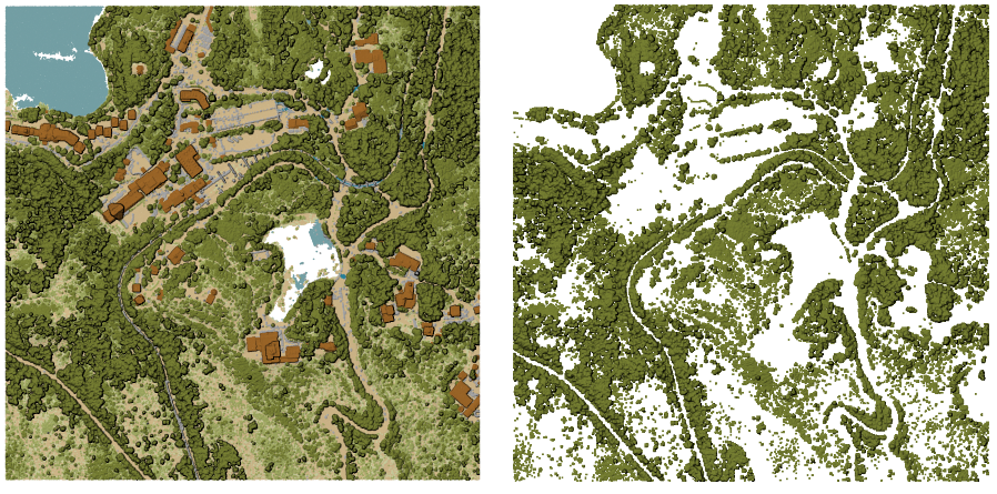
Рис. 24.18 Filtering of high vegetation class from an input point cloud layer
Параметры
Ярлык |
Имя |
Тип |
Описание |
|---|---|---|---|
Исходный слой |
|
[point cloud] |
Input point cloud layer to export |
Filter expression Optional |
|
[expression] |
A PDAL expression for selecting a subset of features in the point cloud data |
Cropping extent Optional |
|
[extent] |
A map extent for selecting a subset of features in the point cloud data Available methods are:
|
Filtered |
|
[point cloud] По умолчанию: |
Specify the point cloud file to export the data to. One of:
|
Результаты
Ярлык |
Имя |
Тип |
Описание |
|---|---|---|---|
Filtered |
|
[point cloud] |
Output point cloud layer with the filtered features of the input point cloud layer.
Currently supported formats are |
Код на Python
Algorithm ID: pdal:filter
import processing
processing.run("algorithm_id", {parameter_dictionary})
ID алгоритма отображается при наведении мыши на алгоритм в Инструментах анализа. Словарь parameter dictionary содержит ключи параметров и их значения. См. Изпользование алгоритмов геообработки в консоли для детального описания того, как запускать алгоритмы анализа из консоли Python.