Svarbu
Vertimas yra bendruomenės pastangos, prie kurių jūs galite prisijungti. Šis puslapis šiuo metu išverstas 70.62%.
24.1.22. Bendri vektoriniai
24.1.22.1. Priskirti projekciją
Priskiria vektoriniam sluoksniui naują projekciją.
Sukuria naują sluoksnį su lygiai tokiais pačiais geoobjektais ir geometrijomis kaip ir įvesties, tik su priskirta nauja CRS. Geometrijos nėra perprojektuojamos, joms tiesiog priskiriama kita CRS.
Šį algoritmą galima naudoti taisant sluoksnius, kuriems buvo priskirta neteisinga projekcija.
Šis algoritmas nekeičia atributų.
Taip pat žiūrėkite
Define Shapefile projection, Find projection, Reproject layer
Parametrai
Užrašas |
Pavadinimas |
Tipas |
Aprašymas |
|---|---|---|---|
Įvesties sluoksnis |
|
[vektorius: geometrija] |
Vektorinis sluoksnis su neteisinga ar trūkstama CRS |
Priskiriama CRS |
|
[crs] Numatyta: |
Parinkite naują CRS, kurią reikia priskirti vektoriniam sluoksniui |
Priskiriama CRS Pasirinktinis |
|
[toks pat, kaip įvestis] Numatytas: |
Nurodykite išvesties vektorinį sluoksnį Vienas iš:
Čia taipogi galima pakeisti failo koduotę. |
Išvestys
Užrašas |
Pavadinimas |
Tipas |
Aprašymas |
|---|---|---|---|
Priskiriama CRS |
|
[toks pat, kaip įvestis] |
Vektorinis sluoksnis su priskirta projekcija |
Pythono kodas
Algoritmo ID: native:assignprojection
import processing
processing.run("algorithm_id", {parameter_dictionary})
algoritmo id rodomas, kai užvedate pelę virš algoritmo apdorojimo įrankinėje. parametrų žodynas teikia parametrų pavadinimus ir reikšmes. Daugiau informacijos apie tai, kaip vykdyti apdorojimo algoritmus Pythono konsolėje rasite skyriuje Using processing algorithms from the console.
24.1.22.2. Paketinis Nominatim geokodavimas
Vykdo paketinį įvesties sluoksnio tekstinio lauko geokodavimą naudojant Nominatim paslaugą. Išvesties sluoksnis turės taško geometriją, atspindinčią geokoduotą vietą bei kelis atributus, susijusius su geokoduota vieta.
 Leidžia taškų geoobjektus keisti vietoje
Pastaba
Šis algoritmas atitinka Nominatim geokodavimo paslaugos, kurią teikia OpenStreetMap Foundation, naudojimo politiką.
Parametrai
Užrašas |
Pavadinimas |
Tipas |
Aprašymas |
|---|---|---|---|
Įvesties sluoksnis |
|
[vektorius: bet koks] |
Vektorinis sluoksnis su geokoduojamais objektais |
Adreso laukas |
|
[lentelės laukas: tekstas] |
Laukas su geokoduojamu adresu |
Geokoduotas |
|
[vektorius: taškai] Numatytas: |
Nurodykite išvesties sluoksnį, kuriame yra tik geokoduoti adresai. Vienas iš:
Čia taipogi galima pakeisti failo koduotę. |
Išvestys
Užrašas |
Pavadinimas |
Tipas |
Aprašymas |
|---|---|---|---|
Geokoduotas |
|
[vektorius: taškai] |
Vektorinis sluoksnis su taškiniais geoobjektais, atitinkančiais geokoduotus adresus |
Pythono kodas
Algoritmo ID: native:batchnominatimgeocoder
import processing
processing.run("algorithm_id", {parameter_dictionary})
algoritmo id rodomas, kai užvedate pelę virš algoritmo apdorojimo įrankinėje. parametrų žodynas teikia parametrų pavadinimus ir reikšmes. Daugiau informacijos apie tai, kaip vykdyti apdorojimo algoritmus Pythono konsolėje rasite skyriuje Using processing algorithms from the console.
24.1.22.3. Keisti sluoksnį į erdvines žymeles
Kuria erdvines žymeles, atitinkančias sluoksnyje esančių geoobjektų apimtis.
Parametrai
Užrašas |
Pavadinimas |
Tipas |
Aprašymas |
|---|---|---|---|
Įvesties sluoksnis |
|
[vektorius: linija, poligonas] |
Įvesties vektorinis sluoksnis |
Žymelių paskirtis |
|
[sąrašas] Numatytas: 0 |
Parinkite žymelių paskirtį. Vienas iš:
|
Pavadinimo laukas |
|
[išraiška] |
Laukas arba išraiška, kuri suteiks sukurtoms žymelėms pavadinimą |
Grupės laukas |
|
[išraiška] |
Laukas ar išraiška, kuri suteiks sukurtoms žymelėms grupes |
Išvestys
Užrašas |
Pavadinimas |
Tipas |
Aprašymas |
|---|---|---|---|
Pridėti žymelių skaičius |
|
[skaičius: sveikas skaičius] |
Pythono kodas
Algoritmo ID: native:layertobookmarks
import processing
processing.run("algorithm_id", {parameter_dictionary})
algoritmo id rodomas, kai užvedate pelę virš algoritmo apdorojimo įrankinėje. parametrų žodynas teikia parametrų pavadinimus ir reikšmes. Daugiau informacijos apie tai, kaip vykdyti apdorojimo algoritmus Pythono konsolėje rasite skyriuje Using processing algorithms from the console.
24.1.22.4. Keisti erdvines žymeles į sluoksnį
Kuria naują sluoksnį, kuriame yra poligono geoobjektai su įrašytomis erdvinėmis žymelėmis. Eksportą galima apriboti tik dabartinio projekto žymelėmis, visomis naudotojo žymelėmis arba abiem.
Parametrai
Užrašas |
Pavadinimas |
Tipas |
Aprašymas |
|---|---|---|---|
Žymelių šaltinis |
|
[enumeration] [list] Numatytas: [0,1] |
Parinktie žymelių šaltinį(ius). Vienas ar daugiau iš:
|
Išvesties CRS |
|
[crs] Numatyta: |
Išvesties sluoksnio CRS |
Išvestis |
|
[vektorius: poligonas] Numatytas: |
Nurodykite išvesties sluoksnį. Vienas iš:
Čia taipogi galima pakeisti failo koduotę. |
Išvestys
Užrašas |
Pavadinimas |
Tipas |
Aprašymas |
|---|---|---|---|
Išvestis |
|
[vektorius: poligonas] |
Išvesties (žymelių) vektorinis sluoksnis |
Pythono kodas
Algoritmo ID: native:bookmarkstolayer
import processing
processing.run("algorithm_id", {parameter_dictionary})
algoritmo id rodomas, kai užvedate pelę virš algoritmo apdorojimo įrankinėje. parametrų žodynas teikia parametrų pavadinimus ir reikšmes. Daugiau informacijos apie tai, kaip vykdyti apdorojimo algoritmus Pythono konsolėje rasite skyriuje Using processing algorithms from the console.
24.1.22.5. Create attribute index
Creates an index against a field of the attribute table to speed up queries. The support for index creation depends on both the layer’s data provider and the field type.
No outputs are created: the index is stored on the layer itself.
Parametrai
Užrašas |
Pavadinimas |
Tipas |
Aprašymas |
|---|---|---|---|
Įvesties sluoksnis |
|
[vektorius: bet koks] |
Select the vector layer you want to create an attribute index for |
Attribute to index |
|
[tablefield: any] |
Field of the vector layer |
Išvestys
Užrašas |
Pavadinimas |
Tipas |
Aprašymas |
|---|---|---|---|
Indexed layer |
|
[toks pat, kaip įvestis] |
A copy of the input vector layer with an index for the specified field |
Pythono kodas
Algorithm ID: native:createattributeindex
import processing
processing.run("algorithm_id", {parameter_dictionary})
algoritmo id rodomas, kai užvedate pelę virš algoritmo apdorojimo įrankinėje. parametrų žodynas teikia parametrų pavadinimus ir reikšmes. Daugiau informacijos apie tai, kaip vykdyti apdorojimo algoritmus Pythono konsolėje rasite skyriuje Using processing algorithms from the console.
24.1.22.6. Create spatial index
Creates an index to speed up access to the features in a layer based on their spatial location. Support for spatial index creation is dependent on the layer’s data provider.
No new output layers are created.
Default menu:
Parametrai
Užrašas |
Pavadinimas |
Tipas |
Aprašymas |
|---|---|---|---|
Įvesties sluoksnis |
|
[vektorius: geometrija] |
Įvesties vektorinis sluoksnis |
Išvestys
Užrašas |
Pavadinimas |
Tipas |
Aprašymas |
|---|---|---|---|
Indexed layer |
|
[toks pat, kaip įvestis] |
A copy of the input vector layer with a spatial index |
Pythono kodas
Algorithm ID: native:createspatialindex
import processing
processing.run("algorithm_id", {parameter_dictionary})
algoritmo id rodomas, kai užvedate pelę virš algoritmo apdorojimo įrankinėje. parametrų žodynas teikia parametrų pavadinimus ir reikšmes. Daugiau informacijos apie tai, kaip vykdyti apdorojimo algoritmus Pythono konsolėje rasite skyriuje Using processing algorithms from the console.
24.1.22.7. Define Shapefile projection
Sets the CRS (projection) of an existing Shapefile format dataset to
the provided CRS.
It is very useful when a Shapefile format dataset is missing the
prj file and you know the correct projection.
Contrary to the Priskirti projekciją algorithm, it modifies the current layer and will not output a new layer.
Pastaba
For Shapefile datasets, the .prj and .qpj files will
be overwritten - or created if missing - to match the provided CRS.
Default menu:
Taip pat žiūrėkite
Parametrai
Užrašas |
Pavadinimas |
Tipas |
Aprašymas |
|---|---|---|---|
Įvesties sluoksnis |
|
[vektorius: geometrija] |
Vector layer with missing projection information |
CRS |
|
[crs] |
Select the CRS to assign to the vector layer |
Išvestys
Užrašas |
Pavadinimas |
Tipas |
Aprašymas |
|---|---|---|---|
|
[toks pat, kaip įvestis] |
The input vector layer with the defined projection |
Pythono kodas
Algorithm ID: qgis:definecurrentprojection
import processing
processing.run("algorithm_id", {parameter_dictionary})
algoritmo id rodomas, kai užvedate pelę virš algoritmo apdorojimo įrankinėje. parametrų žodynas teikia parametrų pavadinimus ir reikšmes. Daugiau informacijos apie tai, kaip vykdyti apdorojimo algoritmus Pythono konsolėje rasite skyriuje Using processing algorithms from the console.
24.1.22.8. Delete duplicate geometries
Finds and removes duplicated geometries.
Attributes are not checked, so in case two features have identical geometries but different attributes, only one of them will be added to the result layer.
Pastaba
This algorithm does not require valid geometries as input.
Taip pat žiūrėkite
Drop geometries, Remove null geometries, Delete duplicates by attribute
Parametrai
Užrašas |
Pavadinimas |
Tipas |
Aprašymas |
|---|---|---|---|
Įvesties sluoksnis |
|
[vektorius: geometrija] |
The layer with duplicate geometries you want to clean |
Cleaned |
|
[toks pat, kaip įvestis] Numatytas: |
Nurodykite išvesties sluoksnį. Vienas iš:
Čia taipogi galima pakeisti failo koduotę. |
Išvestys
Užrašas |
Pavadinimas |
Tipas |
Aprašymas |
|---|---|---|---|
Count of discarded duplicate records |
|
[skaičius: sveikas skaičius] |
Count of discarded duplicate records |
Cleaned |
|
[toks pat, kaip įvestis] |
The output layer without any duplicated geometries |
Count of retained records |
|
[skaičius: sveikas skaičius] |
Count of unique records |
Pythono kodas
Algorithm ID: native:deleteduplicategeometries
import processing
processing.run("algorithm_id", {parameter_dictionary})
algoritmo id rodomas, kai užvedate pelę virš algoritmo apdorojimo įrankinėje. parametrų žodynas teikia parametrų pavadinimus ir reikšmes. Daugiau informacijos apie tai, kaip vykdyti apdorojimo algoritmus Pythono konsolėje rasite skyriuje Using processing algorithms from the console.
24.1.22.9. Delete duplicates by attribute
Deletes duplicate rows by only considering the specified field / fields. The first matching row will be retained, and duplicates will be discarded.
Optionally, these duplicate records can be saved to a separate output for analysis.
Taip pat žiūrėkite
Parametrai
Užrašas |
Pavadinimas |
Tipas |
Aprašymas |
|---|---|---|---|
Įvesties sluoksnis |
|
[vektorius: bet koks] |
Įvesties sluoksnis |
Fields to match duplicates by |
|
[lentelės laukas: bet koks] [sąrašas] |
Fields defining duplicates. Features with identical values for all these fields are considered duplicates. |
Filtered (no duplicates) |
|
[toks pat, kaip įvestis] Numatytas: |
Specify the output layer containing the unique features. One of:
Čia taipogi galima pakeisti failo koduotę. |
Filtered (duplicates) Pasirinktinis |
|
[toks pat, kaip įvestis] Numatytas: |
Nurodykite išvesties sluoksnį, kuriame bus tik dublikatai. Vienas iš:
Čia taipogi galima pakeisti failo koduotę. |
Išvestys
Užrašas |
Pavadinimas |
Tipas |
Aprašymas |
|---|---|---|---|
Filtered (duplicates) Pasirinktinis |
|
[toks pat, kaip įvestis] Numatytas: |
Vector layer containing the removed features.
Will not be produced if not specified (left as
|
Count of discarded duplicate records |
|
[skaičius: sveikas skaičius] |
Count of discarded duplicate records |
Filtered (no duplicates) |
|
[toks pat, kaip įvestis] |
Vector layer containing the unique features. |
Count of retained records |
|
[skaičius: sveikas skaičius] |
Count of unique records |
Pythono kodas
Algorithm ID: native:removeduplicatesbyattribute
import processing
processing.run("algorithm_id", {parameter_dictionary})
algoritmo id rodomas, kai užvedate pelę virš algoritmo apdorojimo įrankinėje. parametrų žodynas teikia parametrų pavadinimus ir reikšmes. Daugiau informacijos apie tai, kaip vykdyti apdorojimo algoritmus Pythono konsolėje rasite skyriuje Using processing algorithms from the console.
24.1.22.10. Detect dataset changes
Compares two vector layers, and determines which features are unchanged, added or deleted between the two. It is designed for comparing two different versions of the same dataset.
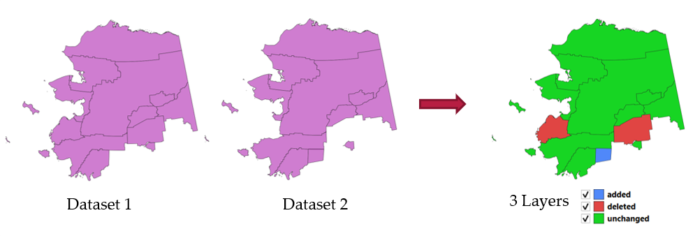
Fig. 24.55 Detect dataset change example
Parametrai
Užrašas |
Pavadinimas |
Tipas |
Aprašymas |
|---|---|---|---|
Original layer |
|
[vektorius: geometrija] |
The vector layer considered as the original version |
Revised layer |
|
[vektorius: geometrija] |
The revised or modified vector layer |
Attributes to consider for match Pasirinktinis |
|
[lentelės laukas: bet koks] [sąrašas] |
Attributes to consider for match. By default, all attributes are compared. |
Geometry comparison behavior Pasirinktinis |
|
[sąrašas] Numatytas: 1 |
Defines the criteria for comparison. Options:
|
Unchanged features Pasirinktinis |
|
[vector: same as Original layer] |
Specify the output vector layer containing the unchanged features. One of:
Čia taipogi galima pakeisti failo koduotę. |
Added features Pasirinktinis |
|
[vector: same as Original layer] |
Specify the output vector layer containing the added features. One of:
Čia taipogi galima pakeisti failo koduotę. |
Deleted features Pasirinktinis |
|
[vector: same as Original layer] |
Specify the output vector layer containing the deleted features. One of:
Čia taipogi galima pakeisti failo koduotę. |
Išvestys
Užrašas |
Pavadinimas |
Tipas |
Aprašymas |
|---|---|---|---|
Unchanged features |
|
[vector: same as Original layer] |
Vector layer containing the unchanged features. |
Added features |
|
[vector: same as Original layer] |
Vector layer containing the added features. |
Deleted features |
|
[vector: same as Original layer] |
Vector layer containing the deleted features. |
Count of unchanged features |
|
[skaičius: sveikas skaičius] |
Count of unchanged features. |
Count of features added in revised layer |
|
[skaičius: sveikas skaičius] |
Count of features added in revised layer. |
Count of features deleted from original layer |
|
[skaičius: sveikas skaičius] |
Count of features deleted from original layer. |
Pythono kodas
Algorithm ID: native:detectvectorchanges
import processing
processing.run("algorithm_id", {parameter_dictionary})
algoritmo id rodomas, kai užvedate pelę virš algoritmo apdorojimo įrankinėje. parametrų žodynas teikia parametrų pavadinimus ir reikšmes. Daugiau informacijos apie tai, kaip vykdyti apdorojimo algoritmus Pythono konsolėje rasite skyriuje Using processing algorithms from the console.
24.1.22.11. Drop geometries
Creates a simple geometryless copy of the input layer attribute table. It keeps the attribute table of the source layer.
If the file is saved in a local folder, you can choose between many file formats.
Leidžia taškų, linijų ir poligonų geoobjektus keisti vietoje
Taip pat žiūrėkite
Parametrai
Užrašas |
Pavadinimas |
Tipas |
Aprašymas |
|---|---|---|---|
Įvesties sluoksnis |
|
[vektorius: geometrija] |
Įvesties vektorinis sluoksnis |
Dropped geometries |
|
[vektorius: lentelė] |
Specify the output geometryless layer. One of:
Čia taipogi galima pakeisti failo koduotę. |
Išvestys
Užrašas |
Pavadinimas |
Tipas |
Aprašymas |
|---|---|---|---|
Dropped geometries |
|
[vektorius: lentelė] |
The output geometryless layer. A copy of the original attribute table. |
Pythono kodas
Algorithm ID: native:dropgeometries
import processing
processing.run("algorithm_id", {parameter_dictionary})
algoritmo id rodomas, kai užvedate pelę virš algoritmo apdorojimo įrankinėje. parametrų žodynas teikia parametrų pavadinimus ir reikšmes. Daugiau informacijos apie tai, kaip vykdyti apdorojimo algoritmus Pythono konsolėje rasite skyriuje Using processing algorithms from the console.
24.1.22.12. Vykdyti SQL
Runs a simple or complex query based only on SELECT with SQL syntax
on the source layer.
Input datasources are identified with input1, input2… inputN and
a simple query will look like SELECT * FROM input1.
Beside a simple query, you can add expressions or variables within the
SQL query parameter itself. This is particulary useful if this algorithm is
executed within a Processing model and you want to use a model input as a
parameter of the query. An example of a query will then be SELECT * FROM
[% @table %] where @table is the variable that identifies the model input.
The result of the query will be added as a new layer.
Taip pat žiūrėkite
Parametrai
Užrašas |
Pavadinimas |
Tipas |
Aprašymas |
|---|---|---|---|
Additional input datasources (called input1, .., inputN in the query) |
|
[vektorius: bet koks] [sąrašas] |
List of layers to query. In the SQL editor you can refer these layers with their real name or also with input1, input2, inputN depending on how many layers have been chosen. |
SQL query |
|
[tekstas] |
Type the string of your SQL query, e.g.
|
Unique identifier field Pasirinktinis |
|
[tekstas] |
Specify the column with unique ID |
Geometry field Pasirinktinis |
|
[tekstas] |
Specify the geometry field |
Geometry type Pasirinktinis |
|
[sąrašas] Numatytas: 0 |
Choose the geometry of the result. By default the algorithm will autodetect it. One of:
|
CRS Pasirinktinis |
|
[crs] |
The CRS to assign to the output layer |
SQL Output |
|
[vektorius: geometrija] Numatytas: |
Specify the output layer created by the query. One of:
Čia taipogi galima pakeisti failo koduotę. |
Išvestys
Užrašas |
Pavadinimas |
Tipas |
Aprašymas |
|---|---|---|---|
SQL Output |
|
[vektorius: geometrija] |
Pagal užklausą sukurtas vektorinis sluoksnis |
Pythono kodas
Algorithm ID: qgis:executesql
import processing
processing.run("algorithm_id", {parameter_dictionary})
algoritmo id rodomas, kai užvedate pelę virš algoritmo apdorojimo įrankinėje. parametrų žodynas teikia parametrų pavadinimus ir reikšmes. Daugiau informacijos apie tai, kaip vykdyti apdorojimo algoritmus Pythono konsolėje rasite skyriuje Using processing algorithms from the console.
24.1.22.13. Export layers to DXF
Exports layers to DXF file. For each layer, you can choose a field whose values are used to split features in generated destination layers in DXF output.
Taip pat žiūrėkite
Parametrai
Užrašas |
Pavadinimas |
Tipas |
Aprašymas |
|---|---|---|---|
Įvesties sluoksniai |
|
[vektorius: geometrija] [sąrašas] |
List of input vector layers with options associated (filled as a
Allow data defined symbol blocks [boolean] (
|
Symbology mode |
|
[sąrašas] Numatytas: 0 |
Type of symbology to apply to output layers. You can choose between:
|
Symbology scale |
|
[scale] Default: 1:1 000 000 |
Default scale of data export. |
Map theme Pasirinktinis |
|
[map theme] |
Match layer styling to the provided map theme. |
Koduotė |
|
[sąrašas] |
Encoding to apply to layers. |
CRS |
|
[crs] |
Choose the CRS for the output layer. |
Apimtis Pasirinktinis |
|
[apimtis] |
Limit exported features to those with geometries intersecting the provided extent. |
Use layer title as name |
|
[boolean] Numatytas: ne |
Name the output layer with the layer title (as set in layer metadata or QGIS Server properties) instead of the layer name. |
Force 2D |
|
[boolean] Numatytas: ne |
|
Export labels as MTEXT elements |
|
[boolean] Numatytas: Taip |
Exports labels as MTEXT or TEXT elements |
Use only selected features |
|
[boolean] Numatytas: ne |
Exports only the selected features. |
DXF |
|
[file] Numatytas: |
Specification of the output DXF file. One of:
|
Išvestys
Užrašas |
Pavadinimas |
Tipas |
Aprašymas |
|---|---|---|---|
DXF |
|
[file] |
|
Pythono kodas
Algorithm ID: native:dxfexport
import processing
processing.run("algorithm_id", {parameter_dictionary})
algoritmo id rodomas, kai užvedate pelę virš algoritmo apdorojimo įrankinėje. parametrų žodynas teikia parametrų pavadinimus ir reikšmes. Daugiau informacijos apie tai, kaip vykdyti apdorojimo algoritmus Pythono konsolėje rasite skyriuje Using processing algorithms from the console.
24.1.22.14. Extract selected features
Saves the selected features as a new layer.
Pastaba
If the selected layer has no selected features, the newly created layer will be empty.
Parametrai
Užrašas |
Pavadinimas |
Tipas |
Aprašymas |
|---|---|---|---|
Įvesties sluoksnis |
|
[vektorius: bet koks] |
Layer to save the selection from |
Selected features |
|
[toks pat, kaip įvestis] Numatytas: |
Specify the vector layer for the selected features. One of:
Čia taipogi galima pakeisti failo koduotę. |
Išvestys
Užrašas |
Pavadinimas |
Tipas |
Aprašymas |
|---|---|---|---|
Selected features |
|
[toks pat, kaip įvestis] |
Vector layer with only the selected features, or no feature if none was selected. |
Pythono kodas
Algorithm ID: native:saveselectedfeatures
import processing
processing.run("algorithm_id", {parameter_dictionary})
algoritmo id rodomas, kai užvedate pelę virš algoritmo apdorojimo įrankinėje. parametrų žodynas teikia parametrų pavadinimus ir reikšmes. Daugiau informacijos apie tai, kaip vykdyti apdorojimo algoritmus Pythono konsolėje rasite skyriuje Using processing algorithms from the console.
24.1.22.15. Extract Shapefile encoding
Extracts the attribute encoding information embedded in a Shapefile.
Both the encoding specified by an optional .cpg file and
any encoding details present in the .dbf LDID header block are considered.
Parametrai
Užrašas |
Pavadinimas |
Tipas |
Aprašymas |
|---|---|---|---|
Įvesties sluoksnis |
|
[vektorius: geometrija] |
ESRI Shapefile ( |
Išvestys
Užrašas |
Pavadinimas |
Tipas |
Aprašymas |
|---|---|---|---|
Shapefile encoding |
|
[tekstas] |
Encoding information specified in the input file |
CPG encoding |
|
[tekstas] |
Encoding information specified in any optional |
LDID encoding |
|
[tekstas] |
Encoding information specified in |
Pythono kodas
Algorithm ID: native:shpencodinginfo
import processing
processing.run("algorithm_id", {parameter_dictionary})
algoritmo id rodomas, kai užvedate pelę virš algoritmo apdorojimo įrankinėje. parametrų žodynas teikia parametrų pavadinimus ir reikšmes. Daugiau informacijos apie tai, kaip vykdyti apdorojimo algoritmus Pythono konsolėje rasite skyriuje Using processing algorithms from the console.
24.1.22.16. Find projection
Creates a shortlist of candidate coordinate reference systems, for instance for a layer with an unknown projection.
The area that the layer is expected to cover must be specified via the target area parameter. The coordinate reference system for this target area must be known to QGIS.
The algorithm operates by testing the layer’s extent in every known reference system and then listing any for which the bounds would be near the target area if the layer was in this projection.
Taip pat žiūrėkite
Priskirti projekciją, Define Shapefile projection, Reproject layer
Parametrai
Užrašas |
Pavadinimas |
Tipas |
Aprašymas |
|---|---|---|---|
Įvesties sluoksnis |
|
[vektorius: geometrija] |
Layer with unknown projection |
Target area for layer (xmin, xmax, ymin, ymax) |
|
[apimtis] |
The area that the layer covers. Galimi metodai yra:
|
CRS candidates |
|
[vektorius: lentelė] Numatytas: |
Specify the table (geometryless layer) for the CRS suggestions (EPSG codes). One of:
Čia taipogi galima pakeisti failo koduotę. |
Išvestys
Užrašas |
Pavadinimas |
Tipas |
Aprašymas |
|---|---|---|---|
CRS candidates |
|
[vektorius: lentelė] |
A table with all the CRS (EPSG codes) of the matching criteria. |
Pythono kodas
Algorithm ID: qgis:findprojection
import processing
processing.run("algorithm_id", {parameter_dictionary})
algoritmo id rodomas, kai užvedate pelę virš algoritmo apdorojimo įrankinėje. parametrų žodynas teikia parametrų pavadinimus ir reikšmes. Daugiau informacijos apie tai, kaip vykdyti apdorojimo algoritmus Pythono konsolėje rasite skyriuje Using processing algorithms from the console.
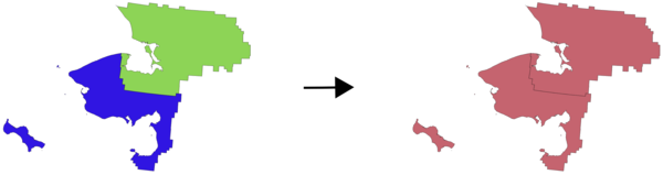
24.1.22.17. Flatten relationship
Flattens a relationship for a vector layer, exporting a single layer containing one parent feature per related child feature. This master feature contains all the attributes for the related features. This allows to have the relation as a plain table that can be e.g. exported to CSV.
Įspėjimas
Šis algoritmas išmeta esamus pirminius raktus ar FID reikšmes ir perkuria jas išvesties sluoksniuose.
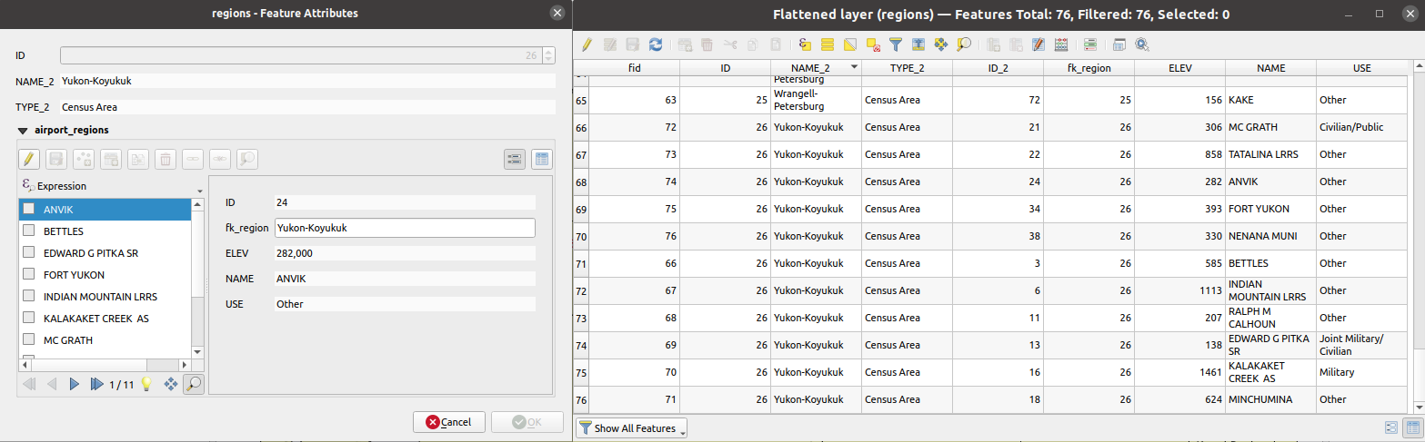
Fig. 24.56 Form of a region with related children (left) - A duplicate region feature for each related child, with joined attributes (right)
Parametrai
Užrašas |
Pavadinimas |
Tipas |
Aprašymas |
|---|---|---|---|
Įvesties sluoksnis |
|
[vektorius: bet koks] |
Layer with the relationship that should be de-normalized |
Flattened Layer Pasirinktinis |
|
[toks pat, kaip įvestis] Numatytas: |
Specify the output (flattened) layer. One of:
Čia taipogi galima pakeisti failo koduotę. |
Išvestys
Užrašas |
Pavadinimas |
Tipas |
Aprašymas |
|---|---|---|---|
Flattened layer |
|
[toks pat, kaip įvestis] |
A layer containing master features with all the attributes for the related features |
Pythono kodas
Algorithm ID: native:flattenrelationships
import processing
processing.run("algorithm_id", {parameter_dictionary})
algoritmo id rodomas, kai užvedate pelę virš algoritmo apdorojimo įrankinėje. parametrų žodynas teikia parametrų pavadinimus ir reikšmes. Daugiau informacijos apie tai, kaip vykdyti apdorojimo algoritmus Pythono konsolėje rasite skyriuje Using processing algorithms from the console.
24.1.22.18. Join attributes by field value
Takes an input vector layer and creates a new vector layer that is an extended version of the input one, with additional attributes in its attribute table.
The additional attributes and their values are taken from a second vector layer. An attribute is selected in each of them to define the join criteria.
Įspėjimas
Šis algoritmas išmeta esamus pirminius raktus ar FID reikšmes ir perkuria jas išvesties sluoksniuose.
Taip pat žiūrėkite
Parametrai
Užrašas |
Pavadinimas |
Tipas |
Aprašymas |
|---|---|---|---|
Įvesties sluoksnis |
|
[vektorius: bet koks] |
Input vector layer. The output layer will consist of the features of this layer with attributes from matching features in the second layer. |
Table field |
|
[tablefield: any] |
Field of the source layer to use for the join |
Input layer 2 |
|
[vektorius: bet koks] |
Layer with the attribute table to join |
Table field 2 |
|
[tablefield: any] |
Field of the second (join) layer to use for the join The type of the field must be equal to (or compatible with) the input table field type. |
Layer 2 fields to copy Pasirinktinis |
|
[lentelės laukas: bet koks] [sąrašas] |
Select the specific fields you want to add. By default all the fields are added. |
Join type |
|
[sąrašas] Numatytas: 1 |
The type of the final joined layer. One of:
|
Discard records which could not be joined |
|
[boolean] Numatytas: Taip |
Check if you don’t want to keep the features that could not be joined |
Joined field prefix Pasirinktinis |
|
[tekstas] |
Add a prefix to joined fields in order to easily identify them and avoid field name collision |
Joined layer Pasirinktinis |
|
[toks pat, kaip įvestis] Numatytas: |
Specify the output vector layer for the join. One of:
Čia taipogi galima pakeisti failo koduotę. |
Unjoinable features from first layer Pasirinktinis |
|
[toks pat, kaip įvestis] Numatytas: |
Specify the output vector layer for unjoinable features from first layer. One of:
Čia taipogi galima pakeisti failo koduotę. |
Išvestys
Užrašas |
Pavadinimas |
Tipas |
Aprašymas |
|---|---|---|---|
Number of joined features from input table |
|
[skaičius: sveikas skaičius] |
|
Unjoinable features from first layer Pasirinktinis |
|
[toks pat, kaip įvestis] |
Vector layer with the non-matched features |
Joined layer Pasirinktinis |
|
[toks pat, kaip įvestis] |
Output vector layer with added attributes from the join |
Number of unjoinable features from input table Pasirinktinis |
|
[skaičius: sveikas skaičius] |
Pythono kodas
Algorithm ID: native:joinattributestable
import processing
processing.run("algorithm_id", {parameter_dictionary})
algoritmo id rodomas, kai užvedate pelę virš algoritmo apdorojimo įrankinėje. parametrų žodynas teikia parametrų pavadinimus ir reikšmes. Daugiau informacijos apie tai, kaip vykdyti apdorojimo algoritmus Pythono konsolėje rasite skyriuje Using processing algorithms from the console.
24.1.22.19. Join attributes by location
Takes an input vector layer and creates a new vector layer that is an extended version of the input one, with additional attributes in its attribute table.
The additional attributes and their values are taken from a second vector layer. A spatial criteria is applied to select the values from the second layer that are added to each feature from the first layer.
Default menu:
Įspėjimas
Šis algoritmas išmeta esamus pirminius raktus ar FID reikšmes ir perkuria jas išvesties sluoksniuose.
Taip pat žiūrėkite
Join attributes by nearest, Join attributes by field value, Join attributes by location (summary)
Erdvinių ryšių tyrinėjimas
Geometriniai predikatai yra funkcijos, kurios naudojamos nustatant, kokį erdvinį ryšį geoobjektas turi su kitu, lyginant ar ir kaip jų geometrijos dalinasi erdvės dalimi.
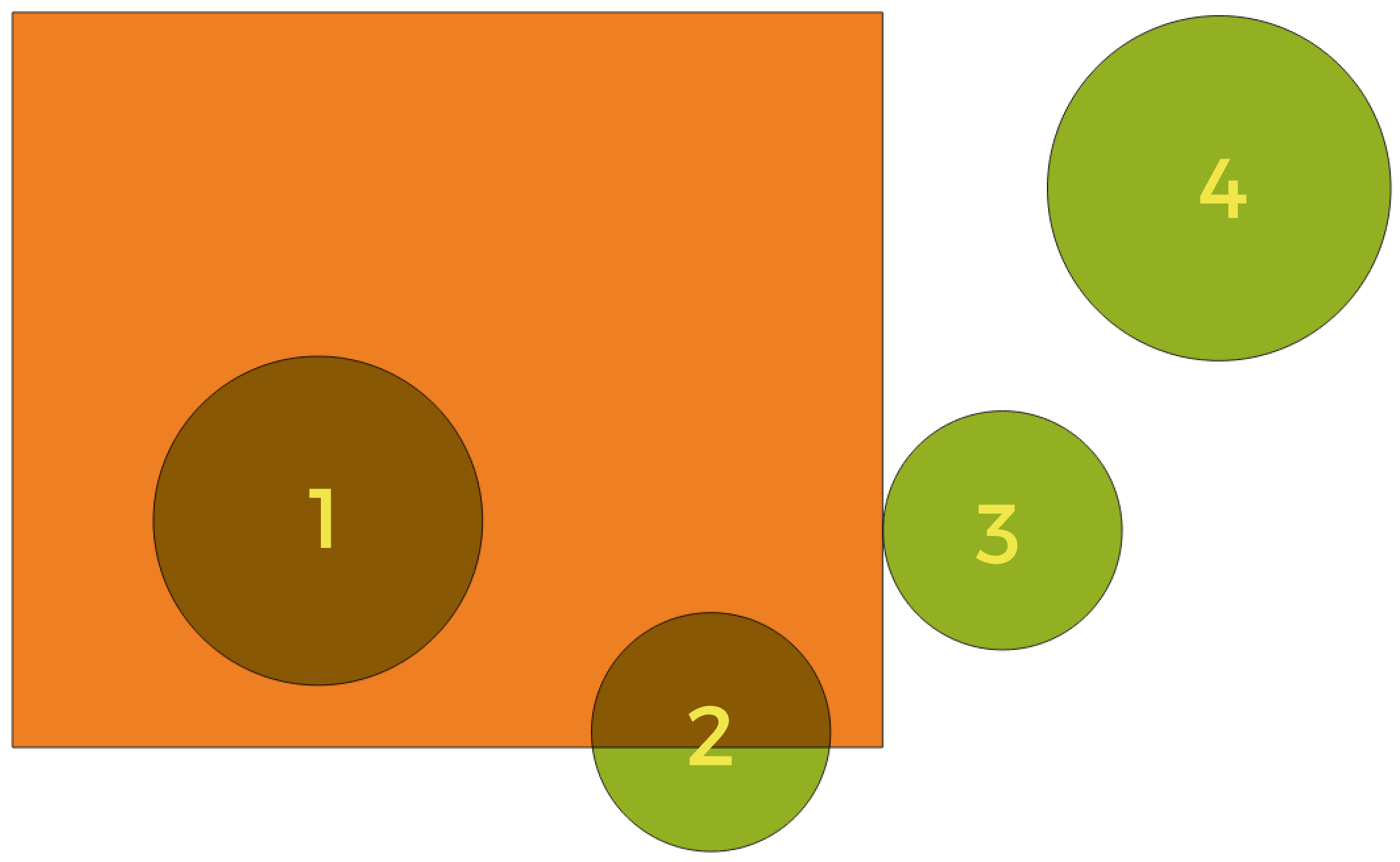
Fig. 24.57 Erdvinių ryšių tarp sluoksnių paieška
Naudojant aukščiau pateiktą iliustraciją, mes ieškome žalių apskritimų, erdviškai lygindami juos su oranžiniu stačiakampiu geoobjektus. Galimi geometriniai predikatai yra:
- Susikerta
Tikrina, ar viena geometrija kerta kitą. Grąžina 1 (true), jei geometrijos erdviškai kertasi (dalinasi kažkokia erdvės dalimi - persidengia arba liečia) ir 0, jei to nėra. Iliustracijoje aukščiau True bus grąžinama apskritimams 1, 2 ir 3.
- Įtraukia
Grąžina 1 (true) tada ir tik tada, jei nei vienas b taškas nėra už a ribų, ir bent vienas b vidaus taškas yra a viduje. Iliustracijoje nei vienas apskritimas nebūtų grąžintas, bet stačiakampis būtų, jei jūs ieškotumėte atvirkščiai, nes pilnai stačiakampyje yra 1 apskritimas. Tai yra priešingybė yra viduje.
- Atskiras
Grąžina 1 (true), jei geometrijos nesidalina jokia erdvės dalimi (nėra persidengimo, nėra susilietimo). Grąžinamas tik 4 apskritimas.
- Lygūs
Grąžina 1 (true), tada ir tik tada, jei geometrijos yra lygiai tokios pačios. Negrąžinami jokie apskritimai.
- Liečia
Tikrina, ar geometrija liečia kitą geometriją. Grąžina 1 (true), jei geometrijos turi bent vieną bendrą tašką, bet jų vidus nepersidengia. Grąžinamas tik 3 apskritimas.
- Persidengia
Tikrina, ar viena geometrija persidengia su kita. Grąžina 1 (true), jei geometrijos dalinasi erdve, turi tokius pačius matmenis, bet nei viena iš jų nėra pilnai kitoje. Grąžinamas tik 2 apskritimas.
- Yra viduje
Tikrina, ar geometrija yra kitos viduje. Grąžina 1 (true), jei geometrija a yra pilnai geometrijos b viduje. Grąžinamas tik apskritimas 1.
- Kerta
Grąžina 1 (true), jei pateiktos geometrijos turi kelis, bet ne visus, bendrus vidaus taškus ir jų susikirtimas turi mažiau matmenų nei daugiausiai matmenų turinti geometrija. Pavyzdžiui, linijos ir poligono susikirtimas bus linija (true). Poligono ir poligono susikirtimas yra poligonas (false). Iliustracijoje nebūtų grąžinamas nei vienas apskritimas.
Parametrai
Užrašas |
Pavadinimas |
Tipas |
Aprašymas |
|---|---|---|---|
Join to features in |
|
[vektorius: geometrija] |
Input vector layer. The output layer will consist of the features of this layer with attributes from matching features in the second layer. |
Where the features |
|
[enumeration] [list] Numatytas: [0] |
Type of spatial relation the source feature should have with the target feature so that they could be joined. One or more of:
Jei parinkta daugiau nei viena sąlyga, bent viena iš jų (OR veiksmas) turi būti tenkinama, kad geoobjektas būtų ištrauktas. |
By comparing to |
|
[vektorius: geometrija] |
The join layer. Features of this vector layer will add their attributes to the source layer attribute table if they satisfy the spatial relationship. |
Fields to add (leave empty to use all fields) Pasirinktinis |
|
[lentelės laukas: bet koks] [sąrašas] |
Select the specific fields you want to add from the join layer. By default all the fields are added. |
Join type |
|
[sąrašas] |
The type of the final joined layer. One of:
|
Discard records which could not be joined |
|
[boolean] Numatytas: ne |
Remove from the output the input layer’s features which could not be joined |
Joined field prefix Pasirinktinis |
|
[tekstas] |
Add a prefix to joined fields in order to easily identify them and avoid field name collision |
Joined layer Pasirinktinis |
|
[toks pat, kaip įvestis] Numatytas: |
Specify the output vector layer for the join. One of:
Čia taipogi galima pakeisti failo koduotę. |
Unjoinable features from first layer Pasirinktinis |
|
[toks pat, kaip įvestis] Numatytas: |
Specify the output vector layer for unjoinable features from first layer. One of:
Čia taipogi galima pakeisti failo koduotę. |
Išvestys
Užrašas |
Pavadinimas |
Tipas |
Aprašymas |
|---|---|---|---|
Number of joined features from input table |
|
[skaičius: sveikas skaičius] |
|
Unjoinable features from first layer Pasirinktinis |
|
[toks pat, kaip įvestis] |
Vector layer of the non-matched features |
Joined layer |
|
[toks pat, kaip įvestis] |
Output vector layer with added attributes from the join |
Pythono kodas
Algorithm ID: native:joinattributesbylocation
import processing
processing.run("algorithm_id", {parameter_dictionary})
algoritmo id rodomas, kai užvedate pelę virš algoritmo apdorojimo įrankinėje. parametrų žodynas teikia parametrų pavadinimus ir reikšmes. Daugiau informacijos apie tai, kaip vykdyti apdorojimo algoritmus Pythono konsolėje rasite skyriuje Using processing algorithms from the console.
24.1.22.20. Join attributes by location (summary)
Takes an input vector layer and creates a new vector layer that is an extended version of the input one, with additional attributes in its attribute table.
The additional attributes and their values are taken from a second vector layer. A spatial criteria is applied to select the values from the second layer that are added to each feature from the first layer.
The algorithm calculates a statistical summary for the values from matching features in the second layer (e.g. maximum value, mean value, etc).
Taip pat žiūrėkite
Erdvinių ryšių tyrinėjimas
Geometriniai predikatai yra funkcijos, kurios naudojamos nustatant, kokį erdvinį ryšį geoobjektas turi su kitu, lyginant ar ir kaip jų geometrijos dalinasi erdvės dalimi.
Fig. 24.58 Erdvinių ryšių tarp sluoksnių paieška
Naudojant aukščiau pateiktą iliustraciją, mes ieškome žalių apskritimų, erdviškai lygindami juos su oranžiniu stačiakampiu geoobjektus. Galimi geometriniai predikatai yra:
- Susikerta
Tikrina, ar viena geometrija kerta kitą. Grąžina 1 (true), jei geometrijos erdviškai kertasi (dalinasi kažkokia erdvės dalimi - persidengia arba liečia) ir 0, jei to nėra. Iliustracijoje aukščiau True bus grąžinama apskritimams 1, 2 ir 3.
- Įtraukia
Grąžina 1 (true) tada ir tik tada, jei nei vienas b taškas nėra už a ribų, ir bent vienas b vidaus taškas yra a viduje. Iliustracijoje nei vienas apskritimas nebūtų grąžintas, bet stačiakampis būtų, jei jūs ieškotumėte atvirkščiai, nes pilnai stačiakampyje yra 1 apskritimas. Tai yra priešingybė yra viduje.
- Atskiras
Grąžina 1 (true), jei geometrijos nesidalina jokia erdvės dalimi (nėra persidengimo, nėra susilietimo). Grąžinamas tik 4 apskritimas.
- Lygūs
Grąžina 1 (true), tada ir tik tada, jei geometrijos yra lygiai tokios pačios. Negrąžinami jokie apskritimai.
- Liečia
Tikrina, ar geometrija liečia kitą geometriją. Grąžina 1 (true), jei geometrijos turi bent vieną bendrą tašką, bet jų vidus nepersidengia. Grąžinamas tik 3 apskritimas.
- Persidengia
Tikrina, ar viena geometrija persidengia su kita. Grąžina 1 (true), jei geometrijos dalinasi erdve, turi tokius pačius matmenis, bet nei viena iš jų nėra pilnai kitoje. Grąžinamas tik 2 apskritimas.
- Yra viduje
Tikrina, ar geometrija yra kitos viduje. Grąžina 1 (true), jei geometrija a yra pilnai geometrijos b viduje. Grąžinamas tik apskritimas 1.
- Kerta
Grąžina 1 (true), jei pateiktos geometrijos turi kelis, bet ne visus, bendrus vidaus taškus ir jų susikirtimas turi mažiau matmenų nei daugiausiai matmenų turinti geometrija. Pavyzdžiui, linijos ir poligono susikirtimas bus linija (true). Poligono ir poligono susikirtimas yra poligonas (false). Iliustracijoje nebūtų grąžinamas nei vienas apskritimas.
Parametrai
Užrašas |
Pavadinimas |
Tipas |
Aprašymas |
|---|---|---|---|
Join to features in |
|
[vektorius: geometrija] |
Input vector layer. The output layer will consist of the features of this layer with attributes from matching features in the second layer. |
Where the features |
|
[enumeration] [list] Numatytas: [0] |
Type of spatial relation the source feature should have with the target feature so that they could be joined. One or more of:
Jei parinkta daugiau nei viena sąlyga, bent viena iš jų (OR veiksmas) turi būti tenkinama, kad geoobjektas būtų ištrauktas. |
By comparing to |
|
[vektorius: geometrija] |
The join layer. Features of this vector layer will add summaries of their attributes to the source layer attribute table if they satisfy the spatial relationship. |
Fields to summarize (leave empty to use all fields) Pasirinktinis |
|
[lentelės laukas: bet koks] [sąrašas] |
Select the specific fields you want to add from the join layer. By default all the fields are added. |
Summaries to calculate (leave empty to use all fields) Pasirinktinis |
|
[enumeration] [list] Default: [] |
For each input feature, statistics are calculated on joined fields of their matching features. One or more of:
|
Discard records which could not be joined |
|
[boolean] Numatytas: ne |
Remove from the output the input layer’s features which could not be joined |
Joined layer |
|
[toks pat, kaip įvestis] Numatytas: |
Specify the output vector layer for the join. One of:
Čia taipogi galima pakeisti failo koduotę. |
Išvestys
Užrašas |
Pavadinimas |
Tipas |
Aprašymas |
|---|---|---|---|
Joined layer |
|
[toks pat, kaip įvestis] |
Output vector layer with summarized attributes from the join |
Pythono kodas
Algorithm ID: qgis:joinbylocationsummary
import processing
processing.run("algorithm_id", {parameter_dictionary})
algoritmo id rodomas, kai užvedate pelę virš algoritmo apdorojimo įrankinėje. parametrų žodynas teikia parametrų pavadinimus ir reikšmes. Daugiau informacijos apie tai, kaip vykdyti apdorojimo algoritmus Pythono konsolėje rasite skyriuje Using processing algorithms from the console.
24.1.22.21. Join attributes by nearest
Takes an input vector layer and creates a new vector layer with additional fields in its attribute table. The additional attributes and their values are taken from a second vector layer. Features are joined by finding the closest features from each layer.
By default only the nearest feature is joined, but the join can also join to the k-nearest neighboring features.
If a maximum distance is specified, only features which are closer than this distance will be matched.
Įspėjimas
Šis algoritmas išmeta esamus pirminius raktus ar FID reikšmes ir perkuria jas išvesties sluoksniuose.
Taip pat žiūrėkite
Nearest neighbour analysis, Join attributes by field value, Join attributes by location, Distance matrix
Parametrai
Užrašas |
Pavadinimas |
Tipas |
Aprašymas |
|---|---|---|---|
Įvesties sluoksnis |
|
[vektorius: geometrija] |
Įvesties sluoksnis. |
Input layer 2 |
|
[vektorius: geometrija] |
The join layer. |
Layer 2 fields to copy (leave empty to copy all fields) |
|
[fields] |
Join layer fields to copy (if empty, all fields will be copied). |
Discard records which could not be joined |
|
[boolean] Numatytas: ne |
Remove from the output the input layer records which could not be joined |
Joined field prefix |
|
[tekstas] |
Joined field prefix |
Maximum nearest neighbors |
|
[skaičius: sveikas skaičius] Numatytas: 1 |
Maximum number of nearest neighbors |
Maximum distance |
|
[skaičius: slankaus kablelio] |
Maximum search distance |
Joined layer Pasirinktinis |
|
[toks pat, kaip įvestis] Numatytas: |
Specify the vector layer containing the joined features. One of:
Čia taipogi galima pakeisti failo koduotę. |
Unjoinable features from first layer |
|
[toks pat, kaip įvestis] Numatytas: |
Specify the vector layer containing the features that could not be joined. One of:
Čia taipogi galima pakeisti failo koduotę. |
Išvestys
Užrašas |
Pavadinimas |
Tipas |
Aprašymas |
|---|---|---|---|
Joined layer |
|
[toks pat, kaip įvestis] |
The output joined layer. |
Unjoinable features from first layer |
|
[toks pat, kaip įvestis] |
Layer containing the features from first layer that could not be joined to any features in the join layer. |
Number of joined features from input table |
|
[skaičius: sveikas skaičius] |
Number of features from the input table that have been joined. |
Number of unjoinable features from input table |
|
[skaičius: sveikas skaičius] |
Number of features from the input table that could not be joined. |
Pythono kodas
Algorithm ID: native:joinbynearest
import processing
processing.run("algorithm_id", {parameter_dictionary})
algoritmo id rodomas, kai užvedate pelę virš algoritmo apdorojimo įrankinėje. parametrų žodynas teikia parametrų pavadinimus ir reikšmes. Daugiau informacijos apie tai, kaip vykdyti apdorojimo algoritmus Pythono konsolėje rasite skyriuje Using processing algorithms from the console.
24.1.22.22. Merge vector layers
Combines multiple vector layers of the same geometry type into a single one.
The attribute table of the resulting layer will contain the fields from all input layers. If fields with the same name but different types are found then the exported field will be automatically converted into a string type field. New fields storing the original layer name and source are also added.
If any input layers contain Z or M values, then the output layer will also contain these values. Similarly, if any of the input layers are multi-part, the output layer will also be a multi-part layer.
Optionally, the destination coordinate reference system (CRS) for the merged layer can be set. If it is not set, the CRS will be taken from the first input layer. All layers will be reprojected to match this CRS.
Default menu:
Įspėjimas
Šis algoritmas išmeta esamus pirminius raktus ar FID reikšmes ir perkuria jas išvesties sluoksniuose.
Taip pat žiūrėkite
Parametrai
Užrašas |
Pavadinimas |
Tipas |
Aprašymas |
|---|---|---|---|
Input Layers |
|
[vektorius: bet koks] [sąrašas] |
The layers that are to be merged into a single layer. Layers should be of the same geometry type. |
Destination CRS Pasirinktinis |
|
[crs] |
Choose the CRS for the output layer. If not specified, the CRS of the first input layer is used. |
Sulietas |
|
[toks pat, kaip įvestis] Numatytas: |
Nurodykite išvesties vektorinį sluoksnį Vienas iš:
Čia taipogi galima pakeisti failo koduotę. |
Išvestys
Užrašas |
Pavadinimas |
Tipas |
Aprašymas |
|---|---|---|---|
Sulietas |
|
[toks pat, kaip įvestis] |
Output vector layer containing all the features and attributes from the input layers. |
Pythono kodas
Algorithm ID: native:mergevectorlayers
import processing
processing.run("algorithm_id", {parameter_dictionary})
algoritmo id rodomas, kai užvedate pelę virš algoritmo apdorojimo įrankinėje. parametrų žodynas teikia parametrų pavadinimus ir reikšmes. Daugiau informacijos apie tai, kaip vykdyti apdorojimo algoritmus Pythono konsolėje rasite skyriuje Using processing algorithms from the console.
24.1.22.23. Order by expression
Sorts a vector layer according to an expression: changes the feature index according to an expression.
Be careful, it might not work as expected with some providers, the order might not be kept every time.
Įspėjimas
Šis algoritmas išmeta esamus pirminius raktus ar FID reikšmes ir perkuria jas išvesties sluoksniuose.
Parametrai
Užrašas |
Pavadinimas |
Tipas |
Aprašymas |
|---|---|---|---|
Įvesties sluoksnis |
|
[vektorius: bet koks] |
Input vector layer to sort |
Išraiška |
|
[išraiška] |
Expression to use for the sorting |
Rikiuoti didėjančiai |
|
[boolean] Numatytas: Taip |
If checked the vector layer will be sorted from small to large values. |
Null reikšmės rikiuotės pradžioje |
|
[boolean] Numatytas: ne |
If checked, Null values are placed first |
Ordered |
|
[toks pat, kaip įvestis] Numatytas: |
Nurodykite išvesties vektorinį sluoksnį Vienas iš:
Čia taipogi galima pakeisti failo koduotę. |
Išvestys
Užrašas |
Pavadinimas |
Tipas |
Aprašymas |
|---|---|---|---|
Ordered |
|
[toks pat, kaip įvestis] |
Output (sorted) vector layer |
Pythono kodas
Algorithm ID: native:orderbyexpression
import processing
processing.run("algorithm_id", {parameter_dictionary})
algoritmo id rodomas, kai užvedate pelę virš algoritmo apdorojimo įrankinėje. parametrų žodynas teikia parametrų pavadinimus ir reikšmes. Daugiau informacijos apie tai, kaip vykdyti apdorojimo algoritmus Pythono konsolėje rasite skyriuje Using processing algorithms from the console.
24.1.22.24. Repair Shapefile
Repairs a broken ESRI Shapefile dataset by (re)creating the SHX file.
Parametrai
Užrašas |
Pavadinimas |
Tipas |
Aprašymas |
|---|---|---|---|
Input Shapefile |
|
[file] |
Full path to the ESRI Shapefile dataset with a missing or broken SHX file |
Išvestys
Užrašas |
Pavadinimas |
Tipas |
Aprašymas |
|---|---|---|---|
Repaired layer |
|
[vektorius: geometrija] |
The input vector layer with the SHX file repaired |
Pythono kodas
Algorithm ID: native:repairshapefile
import processing
processing.run("algorithm_id", {parameter_dictionary})
algoritmo id rodomas, kai užvedate pelę virš algoritmo apdorojimo įrankinėje. parametrų žodynas teikia parametrų pavadinimus ir reikšmes. Daugiau informacijos apie tai, kaip vykdyti apdorojimo algoritmus Pythono konsolėje rasite skyriuje Using processing algorithms from the console.
24.1.22.25. Reproject layer
Reprojects a vector layer in a different CRS. The reprojected layer will have the same features and attributes of the input layer.
Leidžia taškų, linijų ir poligonų geoobjektus keisti vietoje
Taip pat žiūrėkite
Priskirti projekciją, Define Shapefile projection, Find projection
Parametrai
Baziniai parametrai
Užrašas |
Pavadinimas |
Tipas |
Aprašymas |
|---|---|---|---|
Įvesties sluoksnis |
|
[vektorius: geometrija] |
Input vector layer to reproject |
Paskirties CRS |
|
[crs] Numatyta: |
Destination coordinate reference system |
Convert curved geometries to straight segments |
|
[boolean] Numatytas: ne |
If checked, curved geometries will be converted to straight segments in the process, avoiding potential distortion issues. |
Perprojektuota |
|
[toks pat, kaip įvestis] Numatytas: |
Nurodykite išvesties vektorinį sluoksnį Vienas iš:
Čia taipogi galima pakeisti failo koduotę. |
Išmanesni parametrai
Užrašas |
Pavadinimas |
Tipas |
Aprašymas |
|---|---|---|---|
Coordinate Operation Pasirinktinis |
|
[tekstas] |
Specific operation to use for a particular reprojection task, instead of always forcing use of the current project’s transformation settings. Useful when reprojecting a particular layer and control over the exact transformation pipeline is required. Requires proj version >= 6. Read more at Duomenų transformacija. |
Išvestys
Užrašas |
Pavadinimas |
Tipas |
Aprašymas |
|---|---|---|---|
Perprojektuota |
|
[toks pat, kaip įvestis] |
Output (reprojected) vector layer |
Pythono kodas
Algorithm ID: native:reprojectlayer
import processing
processing.run("algorithm_id", {parameter_dictionary})
algoritmo id rodomas, kai užvedate pelę virš algoritmo apdorojimo įrankinėje. parametrų žodynas teikia parametrų pavadinimus ir reikšmes. Daugiau informacijos apie tai, kaip vykdyti apdorojimo algoritmus Pythono konsolėje rasite skyriuje Using processing algorithms from the console.
24.1.22.26. Save vector features to file
Saves vector features to a specified file dataset.
For dataset formats supporting layers, an optional layer name parameter can be used to specify a custom string. Optional GDAL-defined dataset and layer options can be specified. For more information on this, read the online GDAL documentation on the format.
Parametrai
Baziniai parametrai
Užrašas |
Pavadinimas |
Tipas |
Aprašymas |
|---|---|---|---|
Vector features |
|
[vektorius: bet koks] |
Input vector layer. |
Saved features |
|
[toks pat, kaip įvestis] Numatytas: |
Specify the file to save the features to. One of:
|
Išmanesni parametrai
Užrašas |
Pavadinimas |
Tipas |
Aprašymas |
|---|---|---|---|
Layer name Pasirinktinis |
|
[tekstas] |
Name to use for the output layer |
GDAL dataset options Pasirinktinis |
|
[tekstas] |
GDAL dataset creation options of the output format. Separate individual options with semicolons. |
GDAL layer options Pasirinktinis |
|
[tekstas] |
GDAL layer creation options of the output format. Separate individual options with semicolons. |
Action to take on pre-existing file |
|
[sąrašas] Numatytas: 0 |
How to manage existing features. Valid methods are:
|
Išvestys
Užrašas |
Pavadinimas |
Tipas |
Aprašymas |
|---|---|---|---|
Saved features |
|
[toks pat, kaip įvestis] |
Vector layer with the saved features. |
File name and path |
|
[tekstas] |
Output file name and path. |
Layer name |
|
[tekstas] |
Name of the layer, if any. |
Pythono kodas
Algorithm ID: native:savefeatures
import processing
processing.run("algorithm_id", {parameter_dictionary})
algoritmo id rodomas, kai užvedate pelę virš algoritmo apdorojimo įrankinėje. parametrų žodynas teikia parametrų pavadinimus ir reikšmes. Daugiau informacijos apie tai, kaip vykdyti apdorojimo algoritmus Pythono konsolėje rasite skyriuje Using processing algorithms from the console.
24.1.22.27. Set layer encoding
Sets the encoding used for reading a layer’s attributes. No permanent changes are made to the layer, rather it affects only how the layer is read during the current session.
Pastaba
Changing the encoding is only supported for some vector layer data sources.
Parametrai
Užrašas |
Pavadinimas |
Tipas |
Aprašymas |
|---|---|---|---|
Saved features |
|
[vektorius: geometrija] |
Vector layer to set the encoding. |
Koduotė |
|
[tekstas] |
Text encoding to assign to the layer in the current QGIS session. |
Išvestys
Užrašas |
Pavadinimas |
Tipas |
Aprašymas |
|---|---|---|---|
Išvesties sluoksnis |
|
[toks pat, kaip įvestis] |
Input vector layer with the set encoding. |
Pythono kodas
Algorithm ID: native:setlayerencoding
import processing
processing.run("algorithm_id", {parameter_dictionary})
algoritmo id rodomas, kai užvedate pelę virš algoritmo apdorojimo įrankinėje. parametrų žodynas teikia parametrų pavadinimus ir reikšmes. Daugiau informacijos apie tai, kaip vykdyti apdorojimo algoritmus Pythono konsolėje rasite skyriuje Using processing algorithms from the console.
24.1.22.28. Split features by character
Features are split into multiple output features by splitting a field’s value at a specified character. For instance, if a layer contains features with multiple comma separated values contained in a single field, this algorithm can be used to split these values up across multiple output features. Geometries and other attributes remain unchanged in the output. Optionally, the separator string can be a regular expression for added flexibility.
Leidžia taškų, linijų ir poligonų geoobjektus keisti vietoje
Įspėjimas
Šis algoritmas išmeta esamus pirminius raktus ar FID reikšmes ir perkuria jas išvesties sluoksniuose.
Parametrai
Užrašas |
Pavadinimas |
Tipas |
Aprašymas |
|---|---|---|---|
Įvesties sluoksnis |
|
[vektorius: bet koks] |
Įvesties vektorinis sluoksnis |
Split using values in the field |
|
[tablefield: any] |
Field to use for splitting |
Split value using character |
|
[tekstas] |
Character to use for splitting |
Use regular expression separator |
|
[boolean] Numatytas: ne |
|
Split |
|
[toks pat, kaip įvestis] Default: |
Nurodykite išvesties vektorinį sluoksnį Vienas iš:
Čia taipogi galima pakeisti failo koduotę. |
Išvestys
Užrašas |
Pavadinimas |
Tipas |
Aprašymas |
|---|---|---|---|
Split |
|
[toks pat, kaip įvestis] |
The output vector layer. |
Pythono kodas
Algorithm ID: native:splitfeaturesbycharacter
import processing
processing.run("algorithm_id", {parameter_dictionary})
algoritmo id rodomas, kai užvedate pelę virš algoritmo apdorojimo įrankinėje. parametrų žodynas teikia parametrų pavadinimus ir reikšmes. Daugiau informacijos apie tai, kaip vykdyti apdorojimo algoritmus Pythono konsolėje rasite skyriuje Using processing algorithms from the console.
24.1.22.29. Split vector layer
Creates a set of vectors in an output folder based on an input layer and an attribute. The output folder will contain as many layers as the unique values found in the desired field.
The number of files generated is equal to the number of different values found for the specified attribute.
It is the opposite operation of merging.
Default menu:
Taip pat žiūrėkite
Parametrai
Baziniai parametrai
Užrašas |
Pavadinimas |
Tipas |
Aprašymas |
|---|---|---|---|
Įvesties sluoksnis |
|
[vektorius: bet koks] |
Įvesties vektorinis sluoksnis |
Unique ID field |
|
[tablefield: any] |
Field to use for splitting |
Išvesties aplankas |
|
[aplankas] Numatytas: |
Specify the directory for the output layers. One of:
|
Išmanesni parametrai
Užrašas |
Pavadinimas |
Tipas |
Aprašymas |
|---|---|---|---|
Output file type Pasirinktinis |
|
[sąrašas] Default: |
Select the extension of the output files. If not specified or invalid, the output files format will be the one set in the „Default output vector layer extension“ Processing setting. |
Išvestys
Užrašas |
Pavadinimas |
Tipas |
Aprašymas |
|---|---|---|---|
Išvesties aplankas |
|
[aplankas] |
The directory for the output layers |
Output layers |
|
[same as input] [list] |
The output vector layers resulting from the split. |
Pythono kodas
Algorithm ID: native:splitvectorlayer
import processing
processing.run("algorithm_id", {parameter_dictionary})
algoritmo id rodomas, kai užvedate pelę virš algoritmo apdorojimo įrankinėje. parametrų žodynas teikia parametrų pavadinimus ir reikšmes. Daugiau informacijos apie tai, kaip vykdyti apdorojimo algoritmus Pythono konsolėje rasite skyriuje Using processing algorithms from the console.
24.1.22.30. Truncate table
Truncates a layer, by deleting all features from within the layer.
Įspėjimas
This algorithm modifies the layer in place, and deleted features cannot be restored!
Parametrai
Užrašas |
Pavadinimas |
Tipas |
Aprašymas |
|---|---|---|---|
Įvesties sluoksnis |
|
[vektorius: bet koks] |
Įvesties vektorinis sluoksnis |
Išvestys
Užrašas |
Pavadinimas |
Tipas |
Aprašymas |
|---|---|---|---|
Truncated layer |
|
[aplankas] |
The input layer, all features deleted |
Pythono kodas
Algorithm ID: native:truncatetable
import processing
processing.run("algorithm_id", {parameter_dictionary})
algoritmo id rodomas, kai užvedate pelę virš algoritmo apdorojimo įrankinėje. parametrų žodynas teikia parametrų pavadinimus ir reikšmes. Daugiau informacijos apie tai, kaip vykdyti apdorojimo algoritmus Pythono konsolėje rasite skyriuje Using processing algorithms from the console.