8. 탐색기 패널
QGIS 탐색기 패널은 QGIS 리소스를 탐색하고, 검색하고, 점검하고, 복사하고, 불러올 수 있는 훌륭한 도구입니다. QGIS가 어떻게 처리하는지 알고 있는 리소스만 탐색기에 표시됩니다.
탐색기 패널을 사용하면 탐색기 패널 에서 설명한대로 데이터를 찾고, 점검하고, 추가할 수 있습니다. 또한 탐색기 패널은 프로젝트 파일, 파이썬 스크립트, 공간 처리 스크립트, 공간 처리 모델 등과 같은 여러 QGIS 리소스의 드래그&드롭을 지원합니다.
파이썬 스크립트, 공간 처리 스크립트 및 모델은 각각 외부 편집기 및 그래픽 모델 생성기(graphical modeller)에서도 열고 편집할 수 있습니다.
Layers 패널에서 Browser 패널로, 예를 들어 GeoPackage 또는 PostGIS 데이터베이스로 레이어를 드래그&드롭할 수 있습니다.
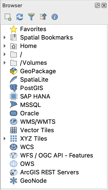
그림 8.1 탐색기 패널
탐색기 패널(그림 8.1)은 탐색기가 처리하는 리소스들을 체계화시키는 몇몇 고정된 최상위 수준 항목들을 가진, 확장 가능한 위계로 이루어져 있습니다. 노드 항목명 왼쪽에 있는  아이콘을 클릭하면 노드 항목을 펼칩니다.
  아이콘을 클릭하면 해당 줄기(branch)를 접습니다.
  Collapse All 버튼을 누르면 모든 최상위 항목을 접습니다.
메뉴에서 리소스들을 비활성화시킬 수 있습니다. 예를 들어 사용자가 탐색기에서 파이썬 스크립트를 보지 않고자 하는 경우 메뉴 항목을 비활성화하면 되고, 탐색기에서 사용자 홈 폴더를 제거하고 싶다면 메뉴 항목을 비활성화하면 됩니다.
항목명 (위계에 있는 잎(leaf) 항목과 노드 항목 둘 다) 기반 검색에 필터( Filter Browser)를 쓸 수 있습니다. 필터 텍스트란 옆에 있는
  Options 풀다운 메뉴를 사용하면:
Case Sensitive 대소문자를 구분하는 검색 기능을 켜고 끌 수 있습니다.
Filter pattern syntax 필터 패턴 문법을 다음 가운데 하나로 설정할 수 있습니다.
Normal
Wildcard(s)
Regular Expressions
 Enable/disable properties widget 버튼을 사용해서 일부 항목/리소스에 대한 유용한 정보를 표시하는 속성 위젯(Properties widget) 을 활성화/비활성화시킬 수 있습니다. 이 위젯을 활성화하면 탐색기 패널 하단에 속성 위젯 그림처럼 표시됩니다.
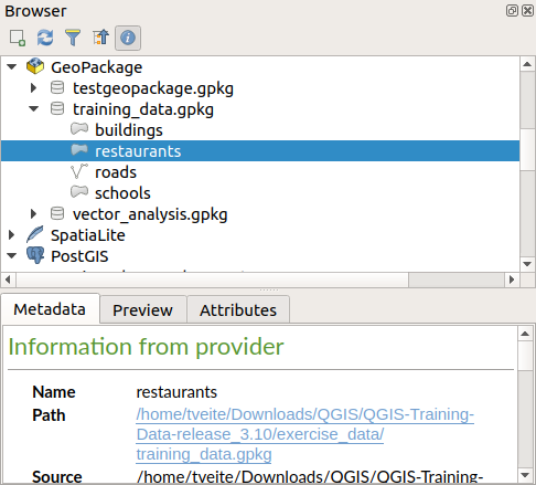
그림 8.2 속성 위젯
메뉴에서 Browser (2) 패널을 활성화하면 두번째 탐색기 패널을 열 수 있습니다. 탐색기 위계에서 서로 다른 가지 깊숙히 위치한 리소스들 사이에 레이어를 복사하는 경우 두번째 탐색기 패널이 있으면 편리합니다.
8.1. 탐색기에서 열/실행할 수 있는 리소스들
탐색기 패널에서 많은 작업을 완수할 수 있습니다:
더블클릭, 맵 캔버스로 드래그, 또는 (레이어를 선택한 다음)
 Add Selected Layers 버튼을 클릭해서 사용자 맵에 벡터, 래스터 및 메시 레이어를 추가할 수 있습니다.
더블클릭 또는 맵 캔버스로 드래그해서 (공간 처리 알고리즘 포함) 파이썬 스크립트를 실행할 수 있습니다.
더블클릭 또는 맵 캔버스로 드래그해서 모델을 실행할 수 있습니다.
Extract Symbols… 컨텍스트 메뉴를 통해 QGIS 프로젝트 파일에서 심볼을 추출할 수 있습니다.
각 파일 유형의 (컨텍스트 메뉴의 Open 1 Externally… 에서 설정하는) 기본 응용 프로그램으로 파일을 열 수 있습니다. 예를 들면 HTML 파일, 스프레드시트, 이미지, PDF, 텍스트 등등의 파일들 말이죠.
항목을 복사할 수 있습니다.
Rename and delete (multiple) layers (context menu: )
Open a file explorer window and directly select the file Show in Files
리소스 전용 액션은 다음에 정리한 최상위 수준 항목 목록 아래 정렬된 서로 다른 리소스 그룹별로 목록화돼 있습니다.
8.2. 탐색기 패널 최상위 수준 항목들
8.2.1. 즐겨찾기
자주 사용하는 파일 시스템 위치를 즐겨찾기로 태그할 수 있습니다. 사용자가 태그한 위치가 여기 나타날 것입니다.
홈(Home) 에서 설명하는 작업들 이외에도, Rename Favorite… 및 Remove Favorite 컨텍스트 메뉴를 통해 즐겨찾기를 재명명하거나 제거할 수 있습니다.
8.2.2. 공간 북마크
여기에서 Project Bookmarks 와 User Bookmarks 로 정리된 사용자 공간 북마크를 찾을 수 있을 것입니다.
최상위 수준 컨텍스트 메뉴에서, 북마크를 생성하고(New Spatial Bookmark…), 공간 북마크 관리자 대화창을 열고(Show the Spatial Bookmark Manager), 공간 북마크를 가져오거나(Import Spatial Bookmarks…) 공간 북마크를 내보낼 수 있습니다(Export Spatial Bookmarks…).
북마크 항목을 통해 공간 북마크가 가리키는 영역으로 확대/축소하고(Zoom to Bookmark), 공간 북마크를 편집하고(Edit Spatial Bookmark…), 공간 북마크를 삭제할 수 있습니다(Delete Spatial Bookmark).
8.2.3. Project Home
Available once the project file has been saved, the Project home entry is a folder containing data and other contents (scripts, models, text, …) that may be used within the current project. Displayed in the Browser panel, it allows you to quickly access data and other files of the project.
It defaults to the project file folder but can be changed through the option, or by right-clicking on the Project Home item of the Browser panel and selecting Set project home…. Customizing that folder is especially useful in contexts where QGIS projects are not stored in the root folder of an organisational ‘project’, along with datasets.
8.2.4. Drives and file system
The next items of the Browser panel depend on the OS in use and concern the top level entries of its file system.
They are mainly:
The Home folder, pointing to the current user home folder
on Unix-based machines, the root / folder
the connected drives, either local or network. Depending on the OS, they are directly listed (eg,
C:\,D:\) or through the/Volumesentry.
From the contextual menu of each of these folders or drives, you can:
refresh the contents
create a subitem that is a Directory, GeoPackage or ESRI Shapefile format dataset
Hide from Browser: 홈 디렉터리를 숨길 수 있습니다.
Set color: customize the folder icon color, aiding in rapid browser navigation of complex folder structures
enable Scanning:
 Monitor for changes: allows to manually control
whether a particular directory should be monitored and automatically updated.
This setting applies to the selected directory and all subdirectories.
This means that you can manually opt-in to monitoring of network drives
if you know there’s no issue, or manually opt-out of monitoring of large
directories which you don’t want monitored for other reasons.
By default, remote or network drives are not automatically monitored.
Monitor for changes: allows to manually control
whether a particular directory should be monitored and automatically updated.
This setting applies to the selected directory and all subdirectories.
This means that you can manually opt-in to monitoring of network drives
if you know there’s no issue, or manually opt-out of monitoring of large
directories which you don’t want monitored for other reasons.
By default, remote or network drives are not automatically monitored. Fast scan this directory
open the directory in your file manager (Open Directory…)
open the directory in a terminal window (Open in Terminal…)
inspect the Properties… or the parent Directory Properties…
8.2.5. Database entries
Depending on your OS and installed drivers, you might have access to different database types to use in QGIS. Below are listed the different entries of contextual menu at each level of the dataset tree.
Level |
Context menu |
Type of database |
|||||
|---|---|---|---|---|---|---|---|
|
|
|
|
|
|
||
Top menu |
Create a New Connection… to an existing database |
|
|
|
|
|
|
Create Database… |
|
|
|||||
Save Connections… details to a file |
|
|
|
||||
Load Connections… |
|
|
|
||||
Connection / Database |
Refresh a connection |
|
|
|
|||
Edit Connection… settings |
|
|
|
||||
Delete Connection |
|
|
|
|
|
||
Delete <database_name> |
|
|
|||||
Compact Database (VACUUM) |
|
||||||
Create a New Schema… |
|
|
|
||||
Create a New Table… |
|
|
|
|
|||
Execute SQL… query |
|
|
|
|
|||
Schema |
Refresh a schema |
|
|
|
|||
|
|
|
|||||
|
|
|
|||||
Create a New Table… |
|
|
|||||
Execute SQL… query |
|
|
|||||
Table / Layer |
|
|
|
||||
|
|
||||||
Execute SQL… query |
|
|
|
||||
|
|
|
|
|
|||
|
|
||||||
|
|
|
|
|
|||
|
|
|
|
|
|||
|
|
|
|
|
|||
|
|
|
|
|
|||
Open Layer Properties… dialog |
|
|
|
|
|
||
Open File Properties… dialog |
|
||||||
Fields |
Add New Field… |
|
|
|
|
||
Field |
Delete Field… |
|
|
|
|
||


8.2.6. Tiles and Web Services
Level |
Context menu |
Type of services |
||||||
|---|---|---|---|---|---|---|---|---|
|
|
|
|
|
|
|
||
Top menu |
Create a New Connection… |
|
|
|
|
|
|
|
Create a New Generic Connection… |
|
|||||||
Create a New ArcGIS Vector Tile Service Connection… |
|
|||||||
Save Connections… details to a file |
|
|
|
|
|
|
|
|
Load Connections… |
|
|
|
|
|
|
|
|
Connection |
Refresh connection |
|
|
|
|
|
|
|
Edit… connection settings |
|
|
|
|
|
|
|
|
Delete connection |
|
|
|
|
|
|
|
|
View Service Info in Web browser |
|
|||||||
Table / Layer |
|
|
|
|
|
|
||
Add layer to Project |
|
|
|
|
|
|
|
|
Open Layer properties… dialog |
|
|
|
|
|
|
|
|
View Service Info in Web browser |
|
|||||||


8.3. 리소스
프로젝트 파일. QGIS 프로젝트 파일의 컨텍스트 메뉴에서:
Open Project: 열 수 있습니다.
Extract Symbols…: 심볼을 추출할 수 있습니다. 스타일 관리자 대화창이 열려 XML 파일로 심볼을 내보내거나, 기본 스타일에 추가하거나, PNG 또는 SVG로 내보낼 수 있습니다.
File Properties…: 속성을 검사할 수 있습니다.
프로젝트 파일을 펼쳐서 프로젝트 레이어를 볼 수 있습니다. 레이어의 컨텍스트 메뉴를 통해 탐색기가 공통적으로 제공하는 액션을 사용할 수 있습니다.
QGIS 레이어 정의 파일(QLR). 컨텍스트 메뉴에서 다음 액션을 사용할 수 있습니다:
: 파일로 내보낼 수 있습니다.
Add Layer to Project: 프로젝트에 추가할 수 있습니다.
Layer Properties…: 속성을 검사할 수 있습니다.
공간 처리 모델(.model3). 컨텍스트 메뉴에서 다음 액션을 사용할 수 있습니다:
Run Model…: 모델을 실행합니다.
Edit Model…: 모델을 편집합니다.
QGIS 인쇄 조판기 템플릿(QPT). 컨텍스트 메뉴에서 다음 액션을 사용할 수 있습니다:
New Layout from Template: 새 조판을 템플릿으로 생성합니다.
파이썬 스크립트(.py). 컨텍스트 메뉴에서 다음 액션을 사용할 수 있습니다:
Run script…: 스크립트를 실행합니다.
Open in External Editor: 스크립트를 외부 편집기로 엽니다.
잘 알려진 래스터 포맷들. 컨텍스트 메뉴에서 다음 액션을 사용할 수 있습니다:
Delete File <dataset name>: 파일을 삭제합니다.
: 파일로 내보낼 수 있습니다.
Add Layer to Project: 프로젝트에 추가할 수 있습니다.
Layer Properties…, File Properties…: 속성을 검사할 수 있습니다.
몇몇 포맷의 경우 Open <file type> Externally… 메뉴도 사용할 수 있습니다.
잘 알려진 벡터 포맷들. 컨텍스트 메뉴에서 다음 액션을 사용할 수 있습니다:
Delete File <dataset name>: 파일을 삭제합니다.
: 파일로 내보낼 수 있습니다.
Add Layer to Project: 프로젝트에 추가할 수 있습니다.
Layer Properties…, File Properties…: 속성을 검사할 수 있습니다.
몇몇 포맷의 경우 Open <file type> Externally… 메뉴도 사용할 수 있습니다.