21.1. GPSプラグイン
21.1.1. GPSとは?
GPS(全地球測位システム)は、GPS受信機を持つ誰もが世界のどこかで自分の正確な位置を見つけることができる、衛星ベースのシステムです。GPSは、ナビゲーション中に助けとして、例えば、航空機、ボート、ハイカーによって使用されます。GPS受信機は、緯度、経度及び(時には)高さを算出する衛星からの信号を使用します。ほとんどの受信機はまた、の位置( ウェイポイント として知られている)、計画された ルート を作る位置の列、および時間をかけて受信機の動きのトラックログあるいは トラック を記憶する機能を持っています。ウェイポイント、ルートおよびトラックはGPSデータの中の3つの基本地物タイプです。QGISでは、ウェイポイントをポイントレイヤーに表示し、ルートやトラックをラインストリングレイヤーに表示します。
注釈
QGISはGNSS受信機もサポートしています。しかし、このドキュメントではGPSという用語を使い続けています。
21.1.2. ファイルからGPSデータを読み込む
GPSデータを格納するための異なるファイル形式はいくつもあります。同じファイル内のウェイポイント、ルートとトラックの任意の数を含むことができ、標準の交換フォーマットであるQGISが使用するフォーマットGPX(GPS交換フォーマット)と呼ばれます。
GPXファイルをロードするには、最初にプラグインをロードする必要があります。  プラグインマネージャ]ダイアログが開きます。
  GPSツール チェックボックスを有効にします。このプラグインがロードされると、小さなハンドヘルドGPS機器とのボタンがツールバーと に表示されます。
 GPS Tools
 新しいGPXレイヤーを作成
GPSデータを扱うために、QGISサンプルデータセット中に利用可能な例GPXファイル qgis_sample_data/GPS/national_monuments.gpx を提供しています。サンプルデータの詳細については、 サンプルデータのダウンロード セクションを参照してください。
Select or click the
GPS Tools icon in the toolbar and open the
Load GPX file tab (see 図 21.1).Browse to the folder
qgis_sample_data/gps/, select the GPX filenational_monuments.gpxand click Open.
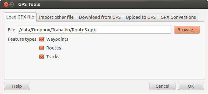
図 21.1 GPSツール ダイアログウィンドウ
Use the Browse... button to select the GPX file, then use the checkboxes
to select the feature types you want to load from that GPX file.
Each feature type will be loaded in a separate layer when you click
OK. The file national_monuments.gpx only includes waypoints.
注釈
GPS units allow you to store data in different coordinate systems. When downloading a GPX file (from your GPS unit or a web site) and then loading it in QGIS, be sure that the data stored in the GPX file uses WGS 84 (latitude/longitude). QGIS expects this, and it is the official GPX specification. See https://www.topografix.com/GPX/1/1/.
21.1.3. GPSBabel
Since QGIS uses GPX files, you need a way to convert other GPS file formats to GPX. This can be done for many formats using the free program GPSBabel, which is available at https://www.gpsbabel.org. This program can also transfer GPS data between your computer and a GPS device. QGIS uses GPSBabel to do these things, so it is recommended that you install it. However, if you just want to load GPS data from GPX files you will not need it. Version 1.2.3 of GPSBabel is known to work with QGIS, but you should be able to use later versions without any problems.
21.1.4. GPSデータをインポートする
GPXファイルではないファイルからGPSデータをインポートする場合 GPSツールダイアログの 他のファイルをインポート ツールを使ってください。ここでインポートしたいファイル(とファイルタイプ)を選択できます。ここではインポートしたい地物タイプと変換して格納するGPXファイルと新しいレイヤーの名前を指定できます。すべてのGPSデータ形式が3種類すべての型をサポートしているわけではありませんから、多くの場合1種類か二種類の形式を選択することになるでしょう。
21.1.5. GPS装置からGPSデータをダウンロードする
QGIS can use GPSBabel to download data from a GPS device directly as new vector layers. For this we use the Download from GPS tab of the GPS Tools dialog (see 図 21.2). Here, we select the type of GPS device, the port that it is connected to (or USB if your GPS supports this), the feature type that you want to download, the GPX file where the data should be stored, and the name of the new layer.
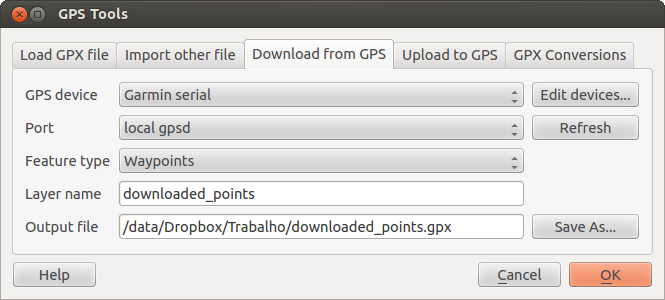
図 21.2 ダウンロードツール
GPSデバイスメニューで選択したデバイスタイプは,GPSBabelがGPSデバイスとどのように接続するかを決定します.GPSデバイスで動作する利用可能なタイプがない場合、新しいタイプを作成することができます(新しいデバイスタイプを定義する のセクションを参照すること).
ポートはファイル名,もしくはオペレーティングシステムがGPSデバイスと接続するコンピュータの物理ポートへの参照として使用する他の名前かもしれません.また, USB対応GPSユニットでは,単に「USB」となる場合もあります.
 Linuxでは
 /dev/ttyS0または/dev/ttyS1のようなものになります Windows では
 COM1またはCOM2となります
When you click OK, the data will be downloaded from the device and appear as a layer in QGIS.
21.1.6. GPSデータをデバイスへアップロードする
また、[GPSツール]ダイアログボックスの GPSにアップロード タブを使用して、QGISでベクターレイヤーからGPSデバイスに直接データをアップロードできます。これを行うには、単にそれが接続されていることを(GPXレイヤーでなければならない)をアップロードしたいレイヤー、GPSデバイスの種類、およびポート(またはUSB)を選択します。お使いのデバイスがリストにない場合は、単にダウンロードツールと同じように、新しいデバイスタイプを指定できます。
このツールは、QGISのベクター編集機能との組み合わせで非常に便利です。それにより、地図をロードし、ウェイポイントとルートを作成し、それらをアップロードし、GPSデバイス上でそれらを使用できます。
21.1.7. 新しいデバイスタイプを定義する
There are lots of different types of GPS devices. The QGIS developers can't test all of them, so if you have one that does not work with any of the device types listed in the Download from GPS and Upload to GPS tools, you can define your own device type for it. You do this by using the GPS device editor, which you start by clicking the Edit Devices button in the download or the upload tab.
To define a new device, you simply click the New Device button,
enter a name, enter download and upload commands for your device, and
click the Update Device button. The name will be listed in the
device menus in the upload and download windows -- it can be any string. The
download command is the command that is used to download data from the device
to a GPX file. This will probably be a GPSBabel command, but you can use any
other command line program that can create a GPX file. QGIS will replace the
keywords %type, %in, and %out when it runs the command.
%type は、ウェイポイントをダウンロードする場合 -w で、トラックをダウンロードする場合 -r で、トラックをダウンロードする場合 -t に置き換わります。これらはどの地物タイプをダウンロードするかをGPSBabelに伝えるためのコマンドラインオプションです。
%i を使用すると、ダウンロードウィンドウで選択し、ポート名に置き換えられます %out は、ダウンロードしたデータは、に格納されなければならないGPXファイルに付ける名前に置き換えられます。だから、downloadコマンド gpsbabel %type -i garmin -o gpx %in %out でデバイスの種類を作成して(これは実際には事前に定義されたデバイスタイプ「ガーミンシリアル」のダウンロードコマンドです)それからポート /dev/ttyS0 からファイル output.gpx へとウェイポイントをダウンロードするためにそれを使用し多場合、QGISではキーワードを置き換えてコマンド gpsbabel -w -i garmin -o gpx /dev/ttyS0 output.gpx を実行するでしょう。
アップロードコマンドはデバイスにデータをアップロードするために使用されます。同様のキーワードが使われますが、 %in はアップロードされるレイヤーに対するGPXファイルの名称に置き換えられ、 %out はポート名称に置き換えられます。
You can learn more about GPSBabel and its available command line options at https://www.gpsbabel.org.
いったん新しいデバイスタイプを作成すると,ダウンロードおよびアップロードツールのデバイスリストに表示されます.
21.1.8. GPSユニットからのポイント/トラックのダウンロード
As described in previous sections QGIS uses GPSBabel to download points/tracks directly in the project. QGIS comes out of the box with a pre-defined profile to download from Garmin devices. Unfortunately there is a bug #6318 that does not allow create other profiles, so downloading directly in QGIS using the GPS Tools is at the moment limited to Garmin USB units.
21.1.8.1. Garmin GPSMAP 60cs
MS Windows
Install the Garmin USB drivers from https://www8.garmin.com/support/download_details.jsp?id=591
ユニットを接続します。GPSツールを開き type=garmin serial と port=usb: を使用します。 レイヤー名 と 出力ファイル フィールドを入力します。時には特定のフォルダに保存するには問題を抱えているようですが、 c:\temp のようなものを使用して通常は動作します。
Ubuntu/Mint GNU/Linux
https://wiki.openstreetmap.org/wiki/USB_Garmin_on_GNU/Linux で説明したように、それは最初に、デバイスのアクセス権についての問題を必要とされています。このルールを含むファイル /etc/udev/rules.d/51-garmin.rules を作成しようとすることができ
ATTRS{idVendor}=="091e", ATTRS{idProduct}=="0003", MODE="666"
その後 garmin_gps カーネルがロードされていないことを確認することが大事です。
rmmod garmin_gps
and then you can use the GPS Tools. Unfortunately there seems to be a bug #7182 and usually QGIS freezes several times before the operation work fine.
21.1.8.2. BTGP-38KM データロガー (Bluetoothのみ)
MS Windows
すでに言及したバグのためQGIS内からデータをダウンロードできませんので、コマンドラインまたはそのインターフェイスを使用してからGPSBabelを使用することが必要とされます。作業コマンドは
gpsbabel -t -i skytraq,baud=9600,initbaud=9600 -f COM9 -o gpx -F C:/GPX/aaa.gpx
Ubuntu/Mint GNU/Linux
Windowsのように同様のコマンド(または GPSBabel GUIを使っているなら設定する)を使います。Linuxでは、それは多分何とか共通のようなメッセージを取得します。
skytraq: Too many read errors on serial port
dataloggerをオン/オフして再び試す問題なだけです。
21.1.8.3. BlueMax GPS-4044 データロガー (BT とUSB両方)
MS Windows
注釈
Windows7ではそれを使用する前にドライバをインストールする必要があります。適切なダウンロードのためにメーカーのサイトを参照してください。
GPSBabelでダウンロードして、USBとBTの両者とも、常にエラーその他を返します。
gpsbabel -t -i mtk -f COM12 -o gpx -F C:/temp/test.gpx
mtk_logger: Can't create temporary file data.bin
Error running gpsbabel: Process exited unsuccessfully with code 1
Ubuntu/Mint GNU/Linux
USBの利用
ケーブルを接続した後、 /dev/ttyACM3 例えば、使用されているものポートを理解するために、 dmesg コマンドを使用します。次に、CLIまたはGUIからの通常の使用GPSBabelとして
gpsbabel -t -i mtk -f /dev/ttyACM3 -o gpx -F /home/user/bluemax.gpx
Bluetoothの利用
GPSBabelを実行し、デバイスをペアリングして、システムのポートを介して、それを利用できるようにBluemanのデバイスマネージャを使用します
gpsbabel -t -i mtk -f /dev/rfcomm0 -o gpx -F /home/user/bluemax_bt.gpx