23.1. Introducing GNSS/GPS Data
23.1.1. O que é GPS?
GPS, the Global Positioning System, is a satellite-based system that allows anyone with a GPS receiver to find their exact position anywhere in the world. GPS is used as an aid in navigation, for example in airplanes, in boats and by hikers. The GPS receiver uses the signals from the satellites to calculate its latitude, longitude and (sometimes) elevation. Most receivers also have the capability to store:
locations (known as waypoints)
sequences of locations that make up a planned route
and a track log of the receiver’s movement over time.
Waypoints, routes and tracks are the three basic feature types in GPS data. QGIS displays waypoints in point layers, while routes and tracks are displayed in linestring layers.
Nota
O QGIS também suporta receptores GNSS. Mas continuamos usando o termo GPS nesta documentação.
23.1.2. Defining GPS device types
There are lots of different types of GPS devices. QGIS allows you to define your own device type and set parameters of use under tab. Read GPSBabel for more details.
Depois de ter criado um novo tipo de dispositivo, ele aparecerá na lista de dispositivos para baixar e atualizar as ferramentas.
23.1.3. Transferring or loading GPS data
Existem dezenas de formatos de arquivo diferentes para armazenar dados GPS. O formato que o QGIS usa é chamado GPX (formato GPS eXchange), que é um formato padrão de intercâmbio que pode conter qualquer número de pontos de passagem, rotas e trilhas no mesmo arquivo.
To load a GPX file:
Open the GPS tab in the Data Source Manager dialog, i.e.:
Click the
 Open Data Source Manager button on the toolbar
(or press Ctrl+L) and enable the target tab
Open Data Source Manager button on the toolbar
(or press Ctrl+L) and enable the target tabOr select

Use the … Browse button next to the GPX dataset option to select the GPX file
Use the check boxes to select the Feature types you want to load from the file. Each feature type (Waypoints, Tracks or Routes) will be loaded in a separate layer.
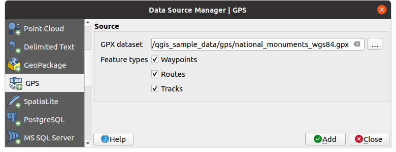
Fig. 23.1 Carregando a janela de dados do GPS
Since QGIS uses GPX files, you need a way to convert other GPS file formats to GPX. This can be done for many formats using the free program GPSBabel. This program can also transfer GPS data between your computer and a GPS device. QGIS relies on GPSBabel to do these things and provides you with convenient Processing algorithms available under the GPS group.
Nota
GPS units allow you to store data in different coordinate systems. When downloading a GPX file (from your GPS unit or a web site) and then loading it in QGIS, be sure that the data stored in the GPX file uses WGS 84 (latitude/longitude). QGIS expects this, and it is the official GPX specification. See GPX 1.1 Schema Documentation.