23.1. GNSS/GPS 데이터 소개
23.1.1. GPS란?
범지구 위치결정 시스템(Global Positioning System) 의 약어인 GPS는 누구나 세계 어디에 있든 GPS 수신기를 가지고 있다면 자신의 정확한 위치를 찾을 수 있게 해주는 위성 기반 시스템입니다. GPS는 예를 들어 비행기, 선박, 또는 도보 여행자의 항법(navigation) 도우미로 사용됩니다. GPS 수신기는 위성이 발신하는 신호를 이용해서 자기 위치의 위도, 경도, 그리고 (때때로) 표고를 계산합니다. 수신기 대부분은 다음을 저장할 수 있는 기능도 가지고 있습니다:
위치 (또는 웨이포인트(waypoint))
계획된 루트(route) 를 구성하는 일련의 위치들
시간에 걸쳐 수신기의 이동을 기록하는 트랙(track) 로그
웨이포인트, 루트 및 트랙은 GPS 데이터의 세 가지 기본 피처 유형들입니다. QGIS는 포인트 레이어에 웨이포인트를 표시하고, 라인스트링 레이어에 루트와 트랙을 표시합니다.
참고
QGIS는 범지구 위성 항법 시스템(Global Navigation Satellite System; GNSS) 수신기도 지원하고 있습니다. 그러나 이 문서에서는 계속 GPS라는 용어를 사용할 것입니다.
23.1.2. GPS 기기 유형 정의하기
수많은 유형의 GPS 기기들이 존재합니다. QGIS는 탭에서 사용자가 자신의 기기 유형을 정의하고 사용할 파라미터를 설정할 수 있게 해줍니다. 더 자세한 내용은 GPSBabel 을 참조하세요.
새 기기 유형을 생성하고 나면, Download from GPS 및 Upload to GPS 탭에 있는 기기 유형 목록에 추가될 것입니다.
23.1.3. GPS 데이터 전송 및 불러오기
GPS 데이터를 저장하기 위한 수십 개의 서로 다른 파일 포맷이 있습니다. QGIS가 이용하는 포맷은 GPX(GPS eXchange format)라고 불리는데, 동일 파일 내에 웨이포인트, 루트 및 트랙을 얼마든지 담을 수 있는 표준 교환(interchange) 포맷입니다.
GPX 파일을 불러오려면:
다음과 같이 Data Source Manager 대화창에 있는 GPS 탭을 여십시오:
툴바에 있는
 Open Data Source Manager 버튼(또는 Ctrl+L 키)을 누른 다음 GPS 탭을 활성화합니다.
또는
 메뉴를 선택합니다.
GPX dataset 옵션 옆에 있는 … Browse 버튼을 눌러 GPX 파일을 선택합니다.
Feature types: 체크 상자를 이용해서 파일에서 불러오고자 하는 피처 유형을 선택하십시오. 각 피처 유형을 (Waypoints, Tracks 또는 Routes) 개별 레이어로 불러올 것입니다.
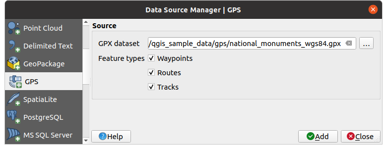
그림 23.1 GPS 데이터 불러오기 대화창
QGIS가 GPX 파일을 사용하기 때문에, 다른 GPS 파일 포맷을 GPX로 변환할 방법이 필요합니다. 자유 소프트웨어 GPSBabel 을 이용하면 많은 포맷들을 변환할 수 있습니다. 이 프로그램은 사용자 컴퓨터와 GPS 기기 간에 GPS 데이터를 전송할 수도 있습니다. QGIS는 이런 작업에 GPSBabel을 사용하기 때문에 GPS 그룹 에서 사용할 수 있는 편리한 공간 처리 알고리즘을 제공하고 있습니다.
참고
GPS 장치는 데이터를 서로 다른 좌표계로 저장할 수 있습니다. 사용자의 GPS 기기 또는 웹사이트에서 GPX 파일을 다운로드해서 QGIS로 불러올 때, GPX 파일에 저장된 데이터가 WGS 84(위도/경도) 좌표계를 사용하고 있는지 확인해야 합니다. QGIS가 이 좌표계를 기대하고 있고, 또 WGS 84가 공식 GPX 사양이기도 합니다. GPX 1.1 스키마 문서 를 참조하세요.