중요
번역은 여러분이 참여할 수 있는 커뮤니티 활동입니다. 이 페이지는 현재 93.16% 번역되었습니다.
24.1.17. 점구름 추출
주의
Running these algorithms requires QGIS installed with PDAL >= 2.5.0 (see menu).
24.1.17.1. 경계
Added in 3.32
점구름 레이어의 경계를 담고 있는 폴리곤 파일을 추출합니다. 구멍을 담고 있을 수도 있으며 다중 부분 폴리곤일 수도 있습니다.
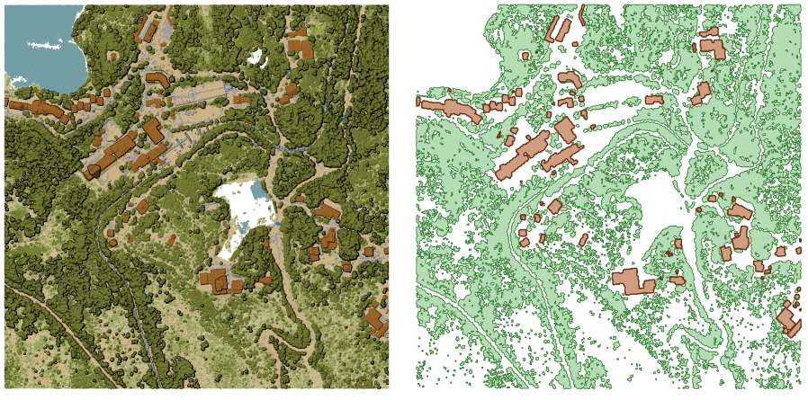
그림 24.47 입력 점구름 레이어에서 상층 식생(high vegetation) 및 건물 폴리곤 추출하기
파라미터
기본 파라미터
라벨 |
이름 |
유형 |
설명 |
|---|---|---|---|
Input layer |
|
[point cloud] |
경계를 계산할 입력 점구름 레이어 |
Resolution of cells used to calculate boundary 선택적 |
|
[numeric: double] |
경계를 계산하는 데 사용한 셀의 해상도 |
Minimal number of points in a cell to consider cell occupied 선택적 |
|
[numeric: integer] |
셀을 차 있다고 간주하려면 필요한 셀 안 포인트의 최소 개수 |
Boundary |
|
[vector: polygon] 기본값: |
Specify the point cloud file to use as output. One of:
|
고급 파라미터
라벨 |
이름 |
유형 |
설명 |
|---|---|---|---|
Filter expression 선택적 |
|
[expression] |
점구름 데이터에 있는 피처의 하위 집합을 선택하기 위한 PDAL 표현식 |
Cropping extent 선택적 |
|
[extent] |
점구름 데이터에 있는 피처의 하위 집합을 선택하기 위한 맵 범위 다음과 같은 메소드를 사용할 수 있습니다: |
산출물
라벨 |
이름 |
유형 |
설명 |
|---|---|---|---|
Boundary |
|
[vector: polygon] |
점구름 경계를 가진 산출 폴리곤 벡터 레이어입니다. 현재 |
파이썬 코드
알고리즘 ID: pdal:boundary
import processing
processing.run("algorithm_id", {parameter_dictionary})
공간 처리 툴박스에 있는 알고리즘 위에 마우스를 가져가면 알고리즘 ID 를 표시합니다. 파라미터 목록(dictionary) 은 파라미터 이름 및 값을 제공합니다. 파이썬 콘솔에서 공간 처리 알고리즘을 어떻게 실행하는지 자세히 알고 싶다면 콘솔에서 공간 처리 알고리즘 사용 을 참조하세요.
24.1.17.2. 밀도
Added in 3.32
각 래스터 셀 내부의 포인트 개수를 바탕으로 한 래스터 파일을 추출합니다. 점구름 데이터셋의 품질을 확인하는 데 유용합니다.
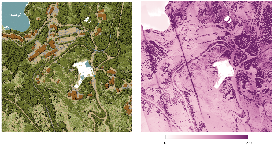
그림 24.48 래스터로써의 포인트 밀도(2x2미터 당 포인트 개수)
파라미터
기본 파라미터
라벨 |
이름 |
유형 |
설명 |
|---|---|---|---|
Input layer |
|
[point cloud] |
내보낼 입력 점구름 레이어 |
Resolution of the density raster |
|
[numeric: double] 기본값: 1.0 |
산출 래스터의 셀 크기 |
Tile size for parallel runs |
|
[numeric: integer] 기본값: 1000 |
병렬 실행을 위해 데이터를 분할시킬 타일의 크기 |
Density |
|
[raster] 기본값: |
Specify the raster file to export the data to. One of:
|
고급 파라미터
라벨 |
이름 |
유형 |
설명 |
|---|---|---|---|
Filter expression 선택적 |
|
[expression] |
점구름 데이터에 있는 피처의 하위 집합을 선택하기 위한 PDAL 표현식 |
Cropping extent 선택적 |
|
[extent] |
점구름 데이터에 있는 피처의 하위 집합을 선택하기 위한 맵 범위 다음과 같은 메소드를 사용할 수 있습니다: |
X origin of a tile for parallel runs 선택적 |
|
[numeric: double] |
|
Y origin of a tile for parallel runs 선택적 |
|
[numeric: double] |
산출물
라벨 |
이름 |
유형 |
설명 |
|---|---|---|---|
Density |
|
[raster] |
각 셀 내부의 포인트 개수를 가진 산출 래스터 레이어입니다. 현재 |
파이썬 코드
알고리즘 ID: pdal:density
import processing
processing.run("algorithm_id", {parameter_dictionary})
공간 처리 툴박스에 있는 알고리즘 위에 마우스를 가져가면 알고리즘 ID 를 표시합니다. 파라미터 목록(dictionary) 은 파라미터 이름 및 값을 제공합니다. 파이썬 콘솔에서 공간 처리 알고리즘을 어떻게 실행하는지 자세히 알고 싶다면 콘솔에서 공간 처리 알고리즘 사용 을 참조하세요.
24.1.17.3. 필터
Added in 3.32
입력 점구름으로부터 PDAL 표현식과 일치하는 그리고/또는 잘라내기(cropping) 직사각형 안에 들어오는 포인트를 추출합니다.
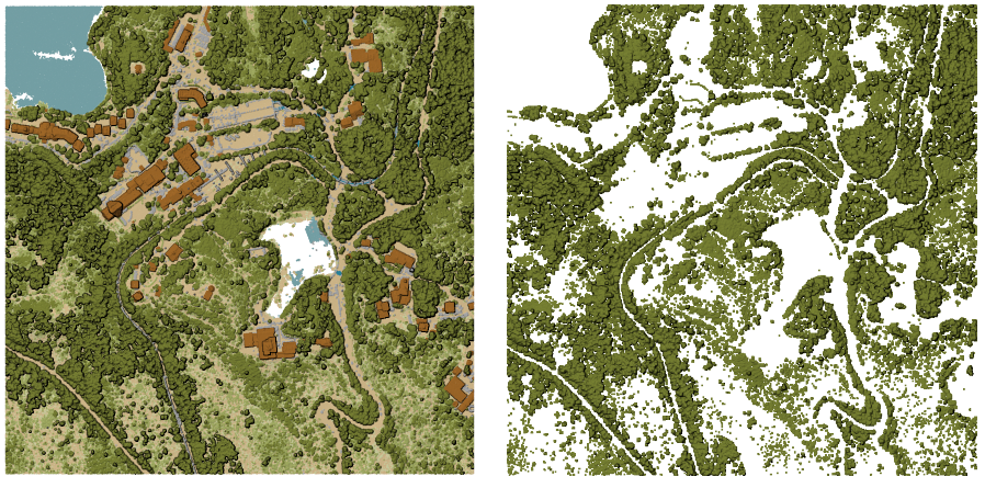
그림 24.49 입력 점구름 레이어에서 상층 식생(high vegetation) 범주로 필터링하기
파라미터
라벨 |
이름 |
유형 |
설명 |
|---|---|---|---|
Input layer |
|
[point cloud] |
내보낼 입력 점구름 레이어 |
Filter expression 선택적 |
|
[expression] |
점구름 데이터에 있는 피처의 하위 집합을 선택하기 위한 PDAL 표현식 |
Cropping extent 선택적 |
|
[extent] |
점구름 데이터에 있는 피처의 하위 집합을 선택하기 위한 맵 범위 다음과 같은 메소드를 사용할 수 있습니다: |
Filtered |
|
[point cloud] 기본값: |
Specify the point cloud file to export the data to. One of:
|
산출물
라벨 |
이름 |
유형 |
설명 |
|---|---|---|---|
Filtered |
|
[point cloud] |
입력 점구름 레이어에서 필터링한 피처를 가진 산출 점구름 레이어입니다. 현재 |
파이썬 코드
알고리즘 ID: pdal:filter
import processing
processing.run("algorithm_id", {parameter_dictionary})
공간 처리 툴박스에 있는 알고리즘 위에 마우스를 가져가면 알고리즘 ID 를 표시합니다. 파라미터 목록(dictionary) 은 파라미터 이름 및 값을 제공합니다. 파이썬 콘솔에서 공간 처리 알고리즘을 어떻게 실행하는지 자세히 알고 싶다면 콘솔에서 공간 처리 알고리즘 사용 을 참조하세요.