重要
Translation is a community effort you can join. This page is currently translated at 54.58%.
28.1.12. Point Cloud Conversion
NEW in 3.32
备注
These algorithms are only available if QGIS uses the PDAL library version 2.5.0 or newer.
28.1.12.1. Convert format
Converts a point cloud to a different file format, e.g. creates a compressed .LAZ.
参数
标注 |
名称 |
类型 |
描述 |
|---|---|---|---|
输入图层 |
|
[point cloud] |
Input point cloud layer to convert |
Converted |
|
[point cloud] 默认: |
Specify the point cloud file to use as output. One of:
|
输出
标注 |
名称 |
类型 |
描述 |
|---|---|---|---|
Converted |
|
[point cloud] |
Output point cloud layer in a modified file format.
Currently supported formats are |
Python代码
Algorithm ID: pdal:convertformat
import processing
processing.run("algorithm_id", {parameter_dictionary})
当你在数据处理工具箱某个算法前悬停时,算法 id 将会展现。*参数字*将会提供参数的名称与数值。参考详见`数据处理_控制台`以获取如何从Python控制台中运行数据处理算法。
28.1.12.2. Export to raster
Exports point cloud data to a 2D raster grid having cell size of given resolution, writing values from the specified attribute.
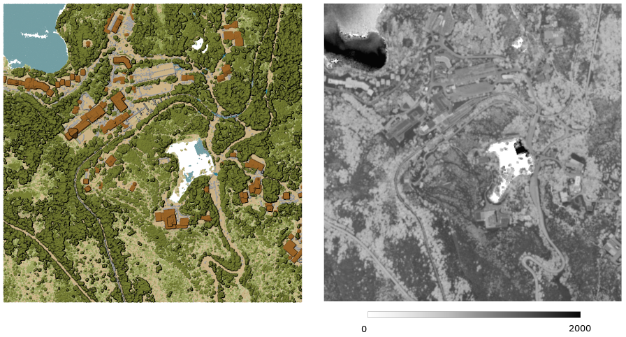
图 28.10 Raster output using Intensity attribute of points
参数
Basic parameters
标注 |
名称 |
类型 |
描述 |
|---|---|---|---|
输入图层 |
|
[point cloud] |
Input point cloud layer to export |
Attribute |
|
[field] [enumeration] |
A Field of the point cloud layer to extract the values from |
Resolution of the density raster |
|
[数字] 默认值:1.0 |
Cell size of the output raster |
Tile size for parallel runs |
|
[数字] Default: 1000 |
|
Exported |
|
[栅格] 默认: |
Specify the raster file to export the data to. One of:
|
Advanced parameters
标注 |
名称 |
类型 |
描述 |
|---|---|---|---|
Filter expression 可选 |
|
[expression] |
A PDAL expression for selecting a subset of features in the point cloud data |
Cropping extent 可选 |
|
[范围] |
A map extent for selecting a subset of features in the point cloud data Available methods are:
|
X origin of a tile for parallel runs 可选 |
|
[数字] |
|
Y origin of a tile for parallel runs 可选 |
|
[数字] |
输出
标注 |
名称 |
类型 |
描述 |
|---|---|---|---|
Exported |
|
[栅格] |
Output raster layer features of the point cloud layer are exported to.
Currently supported format is |
Python代码
Algorithm ID: pdal:exportraster
import processing
processing.run("algorithm_id", {parameter_dictionary})
当你在数据处理工具箱某个算法前悬停时,算法 id 将会展现。*参数字*将会提供参数的名称与数值。参考详见`数据处理_控制台`以获取如何从Python控制台中运行数据处理算法。
28.1.12.3. Export raster (using triangulation)
Exports point cloud data to a 2D raster grid using a triangulation of points and then interpolating cell values from triangles.
备注
Using this algorithm can be slower if you are dealing with a large dataset. If your point cloud is dense, you can export your ground points as a raster using the Export to raster algorithm.
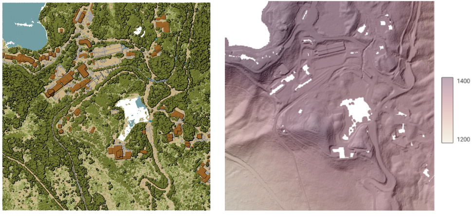
图 28.11 Terrain raster output generated by point cloud triangulation
参数
Basic parameters
标注 |
名称 |
类型 |
描述 |
|---|---|---|---|
输入图层 |
|
[point cloud] |
Input point cloud layer to export |
Resolution of the density raster |
|
[数字] 默认值:1.0 |
Cell size of the output raster |
Tile size for parallel runs |
|
[数字] Default: 1000 |
|
Exported |
|
[栅格] 默认: |
Specify the raster file to export the data to. One of:
|
Advanced parameters
标注 |
名称 |
类型 |
描述 |
|---|---|---|---|
Filter expression 可选 |
|
[expression] |
A PDAL expression for selecting a subset of features in the point cloud data |
Cropping extent 可选 |
|
[范围] |
A map extent for selecting a subset of features in the point cloud data Available methods are:
|
X origin of a tile for parallel runs 可选 |
|
[数字] |
|
Y origin of a tile for parallel runs 可选 |
|
[数字] |
输出
标注 |
名称 |
类型 |
描述 |
|---|---|---|---|
Exported (using triangulation) |
|
[栅格] |
Output raster layer features of the point cloud layer are exported to.
Currently supported format is |
Python代码
Algorithm ID: pdal:exportrastertin
import processing
processing.run("algorithm_id", {parameter_dictionary})
当你在数据处理工具箱某个算法前悬停时,算法 id 将会展现。*参数字*将会提供参数的名称与数值。参考详见`数据处理_控制台`以获取如何从Python控制台中运行数据处理算法。
28.1.12.4. Export to vector
Exports point cloud data to a vector layer with 3D points (a GeoPackage), optionally with extra attributes.
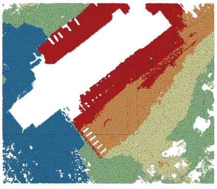
图 28.12 Exporting point cloud (ground points) to a vector layer styled based on the elevation
参数
Basic parameters
标注 |
名称 |
类型 |
描述 |
|---|---|---|---|
输入图层 |
|
[point cloud] |
Input point cloud layer to export |
Attribute 可选 |
|
[field] [list] |
One or more fields of the point cloud layer to export with the points. |
Exported |
|
[vector] 默认: |
Specify the vector file to export the data to. One of:
|
Advanced parameters
标注 |
名称 |
类型 |
描述 |
|---|---|---|---|
Filter expression 可选 |
|
[expression] |
A PDAL expression for selecting a subset of features in the point cloud data |
Cropping extent 可选 |
|
[范围] |
A map extent for selecting a subset of features in the point cloud data Available methods are:
|
输出
标注 |
名称 |
类型 |
描述 |
|---|---|---|---|
Exported |
|
[vector] |
Output vector layer features of the point cloud layer are exported to.
Currently supported format is |
Python代码
Algorithm ID: pdal:exportvector
import processing
processing.run("algorithm_id", {parameter_dictionary})
当你在数据处理工具箱某个算法前悬停时,算法 id 将会展现。*参数字*将会提供参数的名称与数值。参考详见`数据处理_控制台`以获取如何从Python控制台中运行数据处理算法。