Important
Traducerea este un efort al comunității, la care puteți să vă alăturați. În prezent, această pagină este tradusă 65.70%.
24.1.2. Cartography
24.1.2.1. Align points to features
Calculates the rotation required to align point features with their nearest feature from another reference layer. A new field is added to the output layer which is filled with the angle (in degrees, clockwise) to the nearest reference feature.
Optionally, the output layer’s symbology can be set to automatically use the calculated rotation field to rotate marker symbols. If desired, a maximum distance to use when aligning points can be set, to avoid aligning isolated points to distant features.
Sugestie
This algorithm is designed for use cases like aligning building point symbols to follow the nearest road direction.
 Allows features in-place modification
of point features
Allows features in-place modification
of point features
Parametri
Etichetă |
Nume |
Tipul |
Descriere |
|---|---|---|---|
Strat de intrare |
|
[vector: punct] |
Point features to calculate the rotation for |
Reference layer |
|
[vector: geometrie] |
Layer to find the closest feature from for rotation calculation |
Maximum distance to consider Opţional |
|
[numeric: double] Implicit: Nesetat |
If no reference feature is found within this distance, no rotation is assigned to the point feature. |
Angle field name |
|
[șir] Implicit: «rotation» |
Field in which to store the rotation value. |
Automatically apply symbology |
|
[boolean] Implicit: True |
Rotates the symbol marker of the features using the angle field value |
Aligned layer |
|
[vector: punct] Implicit: |
Specify the rotated output vector layer. One of:
The file encoding can also be changed here. |
Rezultat
Etichetă |
Nume |
Tipul |
Descriere |
|---|---|---|---|
Aligned layer |
|
[vector: punct] |
The point layer appended with a rotation field. If loaded to QGIS, it is applied by default the input layer symbology, with a data-defined rotation of its marker symbol. |
Cod Python
ID Algorithm: nativ:angletonearest
import processing
processing.run("algorithm_id", {parameter_dictionary})
ID-ul algoritmului se afișează atunci când treceți peste algoritmul din caseta instrumentelor de procesare. Dicționarul parametrilor furnizează valorile și NUMELE parametrilor. Pentru detalii despre rularea algoritmilor de procesare din consola Python, parcurgeți Utilizarea algoritmilor de procesare din consolă.
24.1.2.2. Combine style databases
Combines multiple QGIS style databases into a single style database. If items of the same type with the same name exist in different source databases these will be renamed to have unique names in the output combined database.
Parametri
Etichetă |
Nume |
Tipul |
Descriere |
|---|---|---|---|
Input databases |
|
[file] [list] |
Files containing QGIS style items |
Objects to combine |
|
[enumeration] [list] |
Types of style items in the input databases you would like to put in the new database. These can be:
|
Output style database |
|
[file] Implicit: |
Output
|
Rezultat
Etichetă |
Nume |
Tipul |
Descriere |
|---|---|---|---|
Color ramp count |
|
[numeric: integer] |
Number of color ramps |
Label settings count |
|
[numeric: integer] |
Number of label settings |
Output style database |
|
[file] |
Output |
Symbol count |
|
[numeric: integer] |
Number of symbols |
Text format count |
|
[numeric: integer] |
Number of text formats |
Cod Python
ID Algorithm: nativ:combinestyles
import processing
processing.run("algorithm_id", {parameter_dictionary})
ID-ul algoritmului se afișează atunci când treceți peste algoritmul din caseta instrumentelor de procesare. Dicționarul parametrilor furnizează valorile și NUMELE parametrilor. Pentru detalii despre rularea algoritmilor de procesare din consola Python, parcurgeți Utilizarea algoritmilor de procesare din consolă.
24.1.2.3. Create categorized renderer from styles
Sets a vector layer’s renderer to a categorized renderer using matching symbols from a style database. If no style file is specified, symbols from the user’s current symbol library are used instead.
A specified expression or field is used to create categories for the renderer. Each category is individually matched to the symbols which exist within the specified QGIS XML style database. Whenever a matching symbol name is found, the category’s symbol will be set to this matched symbol.
If desired, outputs can also be tables containing lists of the categories which could not be matched to symbols, and symbols which were not matched to categories.
Parametri
Etichetă |
Nume |
Tipul |
Descriere |
|---|---|---|---|
Strat de intrare |
|
[vector: oricare] |
Vector layer to apply a categorized style to |
Categorize using expression |
|
[expresie] |
Field or expression to categorize the features |
Style database (leave blank to use saved symbols) |
|
[file] |
File ( |
Use case-sensitive match to symbol names |
|
[boolean] Implicit: False |
If True (checked), applies a case sensitive comparison between the categories and symbols names |
Ignore non-alphanumeric characters while matching |
|
[boolean] Implicit: False |
If True (checked), non-alphanumeric characters in the categories and symbols names will be ignored, allowing greater tolerance during the match. |
Non-matching categories Opţional |
|
[vector: tabelă] Implicit: |
Output table for categories which do not match any symbol in the database. One of:
The file encoding can also be changed here. |
Non-matching symbol names Opţional |
|
[vector: tabelă] Implicit: |
Output table for symbols from the provided style database which do not match any category. One of:
The file encoding can also be changed here. |
Rezultat
Etichetă |
Nume |
Tipul |
Descriere |
|---|---|---|---|
Non-matching categories |
|
[vector: tabelă] |
Lists categories which could not be matched to any symbol in the provided style database |
Non-matching symbol names |
|
[vector: tabelă] |
Lists symbols from the provided style database which could not match any category |
Categorized layer |
|
[la fel ca intrarea] |
The input vector layer with the categorized style applied. No new layer is output. |
Cod Python
ID Algorithm: nativ:categorizeusingstyle
import processing
processing.run("algorithm_id", {parameter_dictionary})
ID-ul algoritmului se afișează atunci când treceți peste algoritmul din caseta instrumentelor de procesare. Dicționarul parametrilor furnizează valorile și NUMELE parametrilor. Pentru detalii despre rularea algoritmilor de procesare din consola Python, parcurgeți Utilizarea algoritmilor de procesare din consolă.
24.1.2.4. Create style database from project
Extracts all style objects (symbols, color ramps, text formats and label settings) from a QGIS project.
The extracted symbols are saved to a QGIS style database (XML format),
which can be managed and imported via the Style Manager
dialog.
Vezi și
Parametri
Etichetă |
Nume |
Tipul |
Descriere |
|---|---|---|---|
Input project (leave blank to use current) Opţional |
|
[file] |
A QGIS project file to extract the style items from |
Objects to extract |
|
[enumeration] [list] |
Types of style items in the input project you would like to put in the new database. These can be:
|
Output style database |
|
[file] Implicit: |
Specify the output
|
Rezultat
Etichetă |
Nume |
Tipul |
Descriere |
|---|---|---|---|
Color ramp count |
|
[numeric: integer] |
Number of color ramps |
Label settings count |
|
[numeric: integer] |
Number of label settings |
Output style database |
|
[file] |
Output |
Symbol count |
|
[numeric: integer] |
Number of symbols |
Text format count |
|
[numeric: integer] |
Number of text formats |
Cod Python
ID Algorithm: nativ:stylefromproject
import processing
processing.run("algorithm_id", {parameter_dictionary})
ID-ul algoritmului se afișează atunci când treceți peste algoritmul din caseta instrumentelor de procesare. Dicționarul parametrilor furnizează valorile și NUMELE parametrilor. Pentru detalii despre rularea algoritmilor de procesare din consola Python, parcurgeți Utilizarea algoritmilor de procesare din consolă.
24.1.2.5. Export atlas layout as image
Exports the atlas of a print layout as image files (e.g. PNG or JPEG images).
If a coverage layer is set, the selected layout’s atlas settings exposed in this algorithm will be overwritten. In this case, an empty filter or sort by expression will turn those settings off.
Parametri
Parametri de bază
Etichetă |
Nume |
Tipul |
Descriere |
|---|---|---|---|
Atlas layout |
|
[layout] |
Layout to export |
Coverage layer Opţional |
|
[vector: geometrie] |
Layer to use to generate the atlas |
Filter expression |
|
[expresie] |
Expression to use to filter out atlas features |
Sort expression Opţional |
|
[expresie] |
Expression to use to sort the atlas features |
Reverse sort order |
|
[boolean] Implicit: False |
Determines if sorting should be inverted. Used when a sort expression is provided. |
Output filename expression |
|
[expresie] Implicit: «output_»||@atlas_featurenumber |
Expression for use to generate filenames |
Output folder |
|
[folder] |
Destination folder where the images will be generated |
Parametri avansați
Etichetă |
Nume |
Tipul |
Descriere |
|---|---|---|---|
Map layers to assign to unlocked map item(s) Opţional |
|
[enumeration] [layer] |
Layers to display in the map item(s) whose contents are not locked |
Image format |
|
[enumerare] Implicit: png |
File format of the generated output(s). The list of available formats varies depending on OS and installed drivers. |
DPI Opţional |
Implicit: Nesetat |
[numeric: double] |
DPI of the output file(s). If not set, the value in the print layout settings will be used. |
Generate world file |
|
[boolean] Implicit: True |
Determines if a world file should be generated |
Export RDF metadata |
|
[boolean] Implicit: True |
Determines if RDF metadata (title, author, …) should be generated |
Enable antialiasing |
|
[boolean] Implicit: True |
Determines if antialiasing should be enabled |
Rezultat
Etichetă |
Nume |
Tipul |
Descriere |
|---|---|---|---|
Image file |
|
[file] |
Image files generated by the atlas layout |
Cod Python
ID Algorithm: nativ:atlaslayouttoimage
import processing
processing.run("algorithm_id", {parameter_dictionary})
ID-ul algoritmului se afișează atunci când treceți peste algoritmul din caseta instrumentelor de procesare. Dicționarul parametrilor furnizează valorile și NUMELE parametrilor. Pentru detalii despre rularea algoritmilor de procesare din consola Python, parcurgeți Utilizarea algoritmilor de procesare din consolă.
24.1.2.6. Export atlas layout as PDF (multiple files)
Exports the atlas of a print layout to multiple PDF files.
If a coverage layer is set, the selected layout’s atlas settings exposed in this algorithm will be overwritten. In this case, an empty filter or sort by expression will turn those settings off.
Parametri
Parametri de bază
Etichetă |
Nume |
Tipul |
Descriere |
|---|---|---|---|
Atlas layout |
|
[layout] |
Layout to export |
Coverage layer Opţional |
|
[vector: geometrie] |
Layer to use to generate the atlas |
Filter expression |
|
[expresie] |
Expression to use to filter out atlas features |
Sort expression Opţional |
|
[expresie] |
Expression to use to sort the atlas features |
Reverse sort order |
|
[boolean] Implicit: False |
Determines if sorting should be inverted. Used when a sort expression is provided. |
Output filename Opţional |
|
[expresie] |
Name pattern of the PDF output files. |
Output folder |
|
[folder] |
Destination folder for the output PDF files. |
Parametri avansați
Etichetă |
Nume |
Tipul |
Descriere |
|---|---|---|---|
Map layers to assign to unlocked map item(s) Opţional |
|
[enumeration] [layer] |
Layers to display in the map item(s) whose contents are not locked |
DPI Opţional |
Implicit: Nesetat |
[numeric: double] |
DPI of the output file(s). If not set, the value in the print layout settings will be used. |
Always export as vectors |
|
[boolean] Implicit: False |
Determines if vectorial data should be left as vectors |
Always export as raster |
|
[boolean] Implicit: False |
Forces all the items in the map to be rasterized.
This parameter takes precedence over the |
Append georeference information |
|
[boolean] Implicit: True |
Determines if a world file should be generated |
Export RDF metadata |
|
[boolean] Implicit: True |
Determines if RDF metadata (title, author, …) should be generated |
Disable tiled raster layer exports |
|
[boolean] Implicit: False |
Determines if raster should be tiled |
Simplify geometries to reduce output file size |
|
[boolean] Implicit: True |
Determines if geometries should be simplified to reduce output file size |
Text export |
|
[enumerare] Implicit: 0 |
Determines if text should be exported as path or text objects. Possible options are:
|
Image compression |
|
[enumerare] Implicit: 0 |
Determines compression level of the image and how suitable the file could be for printing outputs or post-production in external applications. Possible options are:
|
Rezultat
Etichetă |
Nume |
Tipul |
Descriere |
|---|---|---|---|
PDF file |
|
[file] |
PDF file corresponding to the exported atlas layout |
Cod Python
ID algoritm: native:atlaslayouttomultiplepdf
import processing
processing.run("algorithm_id", {parameter_dictionary})
ID-ul algoritmului se afișează atunci când treceți peste algoritmul din caseta instrumentelor de procesare. Dicționarul parametrilor furnizează valorile și NUMELE parametrilor. Pentru detalii despre rularea algoritmilor de procesare din consola Python, parcurgeți Utilizarea algoritmilor de procesare din consolă.
24.1.2.7. Export atlas layout as PDF (single file)
Exports the atlas of a print layout as a single PDF file.
If a coverage layer is set, the selected layout’s atlas settings exposed in this algorithm will be overwritten. In this case, an empty filter or sort by expression will turn those settings off.
Parametri
Parametri de bază
Etichetă |
Nume |
Tipul |
Descriere |
|---|---|---|---|
Atlas layout |
|
[layout] |
Layout to export |
Coverage layer Opţional |
|
[vector: geometrie] |
Layer to use to generate the atlas |
Filter expression |
|
[expresie] |
Expression to use to filter out atlas features |
Sort expression Opţional |
|
[expresie] |
Expression to use to sort the atlas features |
Reverse sort order |
|
[boolean] Implicit: False |
Determines if sorting should be inverted. Used when a sort expression is provided. |
PDF file |
|
[file] Implicit: [Salvare într-un fișier temporar] |
Name (including path) of the output file. One of:
|
Parametri avansați
Etichetă |
Nume |
Tipul |
Descriere |
|---|---|---|---|
Map layers to assign to unlocked map item(s) Opţional |
|
[enumeration] [layer] |
Layers to display in the map item(s) whose contents are not locked |
DPI Opţional |
Implicit: Nesetat |
[numeric: double] |
DPI of the output file(s). If not set, the value in the print layout settings will be used. |
Always export as vectors |
|
[boolean] Implicit: False |
Determines if vectorial data should be left as vectors |
Always export as raster |
|
[boolean] Implicit: False |
Forces all the items in the map to be rasterized.
This parameter takes precedence over the |
Append georeference information |
|
[boolean] Implicit: True |
Determines if a world file should be generated |
Export RDF metadata |
|
[boolean] Implicit: True |
Determines if RDF metadata (title, author, …) should be generated |
Disable tiled raster layer exports |
|
[boolean] Implicit: False |
Determines if raster should be tiled |
Simplify geometries to reduce output file size |
|
[boolean] Implicit: True |
Determines if geometries should be simplified to reduce output file size |
Text export |
|
[enumerare] Implicit: 0 |
Determines if text should be exported as path or text objects. Possible options are:
|
Image compression |
|
[enumerare] Implicit: 0 |
Determines compression level of the image and how suitable the file could be for printing outputs or post-production in external applications. Possible options are:
|
Rezultat
Etichetă |
Nume |
Tipul |
Descriere |
|---|---|---|---|
PDF file |
|
[file] |
PDF file corresponding to the exported atlas layout |
Cod Python
ID Algorithm: nativ:atlaslayouttopdf
import processing
processing.run("algorithm_id", {parameter_dictionary})
ID-ul algoritmului se afișează atunci când treceți peste algoritmul din caseta instrumentelor de procesare. Dicționarul parametrilor furnizează valorile și NUMELE parametrilor. Pentru detalii despre rularea algoritmilor de procesare din consola Python, parcurgeți Utilizarea algoritmilor de procesare din consolă.
24.1.2.8. Export print layout as image
Exports a print layout as an image file (e.g. PNG or JPEG images)
Parametri
Parametri de bază
Etichetă |
Nume |
Tipul |
Descriere |
|---|---|---|---|
Print layout |
|
[layout] |
Layout to export |
Image file |
|
[file] Implicit: [Salvare într-un fișier temporar] |
Name (including path) of the output file. One of:
|
Parametri avansați
Etichetă |
Nume |
Tipul |
Descriere |
|---|---|---|---|
Map layers to assign to unlocked map item(s) Opţional |
|
[enumeration] [layer] |
Layers to display in the map item(s) whose contents are not locked |
DPI Opţional |
Implicit: Nesetat |
[numeric: double] |
DPI of the output file(s). If not set, the value in the print layout settings will be used. |
Generate world file |
|
[boolean] Implicit: True |
Determines if a world file should be generated |
Export RDF metadata |
|
[boolean] Implicit: True |
Determines if RDF metadata (title, author, …) should be generated |
Enable antialiasing |
|
[boolean] Implicit: True |
Determines if antialiasing should be enabled |
Rezultat
Etichetă |
Nume |
Tipul |
Descriere |
|---|---|---|---|
Image file |
|
[file] |
Image file corresponding to the exported print layout |
Cod Python
ID Algorithm: nativ:printlayouttoimage
import processing
processing.run("algorithm_id", {parameter_dictionary})
ID-ul algoritmului se afișează atunci când treceți peste algoritmul din caseta instrumentelor de procesare. Dicționarul parametrilor furnizează valorile și NUMELE parametrilor. Pentru detalii despre rularea algoritmilor de procesare din consola Python, parcurgeți Utilizarea algoritmilor de procesare din consolă.
24.1.2.9. Export print layout as PDF
Exports a print layout as a PDF file.
Parametri
Parametri de bază
Etichetă |
Nume |
Tipul |
Descriere |
|---|---|---|---|
Print Layout |
|
[layout] |
Layout to export |
PDF file |
|
[file] Implicit: [Salvare într-un fișier temporar] |
Name (including path) of the output file. One of:
|
Parametri avansați
Etichetă |
Nume |
Tipul |
Descriere |
|---|---|---|---|
Map layers to assign to unlocked map item(s) Opţional |
|
[enumeration] [layer] |
Layers to display in the map item(s) whose contents are not locked |
DPI Opţional |
Implicit: Nesetat |
[numeric: double] |
DPI of the output file(s). If not set, the value in the print layout settings will be used. |
Always export as vectors |
|
[boolean] Implicit: False |
Determines if vectorial data should be left as vectors |
Always export as raster |
|
[boolean] Implicit: False |
Forces all the items in the map to be rasterized.
This parameter takes precedence over the |
Append georeference information |
|
[boolean] Implicit: True |
Determines if a world file should be generated |
Export RDF metadata |
|
[boolean] Implicit: True |
Determines if RDF metadata (title, author, …) should be generated |
Disable tiled raster layer exports |
|
[boolean] Implicit: False |
Determines if raster should be tiled |
Simplify geometries to reduce output file size |
|
[boolean] Implicit: True |
Determines if geometries should be simplified to reduce output file size |
Text export |
|
[enumerare] Implicit: 0 |
Determines if text should be exported as path or text objects. Possible options are:
|
Image compression |
|
[enumerare] Implicit: 0 |
Determines compression level of the image and how suitable the file could be for printing outputs or post-production in external applications. Possible options are:
|
Export layers as separate PDF files |
|
[boolean] Implicit: False |
If True, then a separate PDF file will be created per layer per map item in the layout. Additionally, separate PDF files may be created for other complex layout items, resulting in a set of PDF files which contain logical atomic components of the layout. |
Rezultat
Etichetă |
Nume |
Tipul |
Descriere |
|---|---|---|---|
PDF file |
|
[file] |
PDF file(s) corresponding to the exported print layout |
Cod Python
ID Algorithm: nativ:printlayouttopdf
import processing
processing.run("algorithm_id", {parameter_dictionary})
ID-ul algoritmului se afișează atunci când treceți peste algoritmul din caseta instrumentelor de procesare. Dicționarul parametrilor furnizează valorile și NUMELE parametrilor. Pentru detalii despre rularea algoritmilor de procesare din consola Python, parcurgeți Utilizarea algoritmilor de procesare din consolă.
24.1.2.10. Extract labels
Extracts label information from a rendered map at a given extent and scale.
If a map theme is provided, the rendered map will match the visibility and symbology of that theme. If left blank, all visible layers from the project will be used. Extracted label information include: position (served as point geometries), the associated layer name and feature ID, label text, rotation (in degree, clockwise), multiline alignment, and font details.
Atenționare
This algorithm drops existing primary keys or FID values and regenerates them in output layers.
Parametri
Parametri de bază
Etichetă |
Nume |
Tipul |
Descriere |
|---|---|---|---|
Map extent |
|
[extent] |
Extent of the map to extract the labels from Metodele disponibile sunt:
|
Map scale |
|
[scale] |
Extracted labels will be rendered using their properties set at this scale. |
Map theme Opţional |
|
[maptheme] |
A map theme displaying the layers to extract the labels from. If unset, labels of the currently visible layers are extracted. |
Include unplaced labels |
|
[boolean] Implicit: True |
Specify whether all overlapping labels should be extracted, including the conflicting (thus unplaced) ones. |
Extracted labels |
|
[vector: punct] Implicit: |
Specify the output vector layer for the extent(s). One of:
The file encoding can also be changed here. |
Parametri avansați
Etichetă |
Nume |
Tipul |
Descriere |
|---|---|---|---|
Map resolution (in DPI) Opţional |
Implicit: 96.0 |
[numeric: double] |
Rezultat
Etichetă |
Nume |
Tipul |
Descriere |
|---|---|---|---|
Extracted labels |
|
[vector: punct] |
Point vector layer representing the fetched labels. Each feature has attributes identifying its source (layer, feature ID) and the assigned labeling properties (text, font, size, rotation, …). A default style with labeling and null symbol is also applied to the layer. Atenționare Because some of the generated fields have name with more than
10 characters, using the ESRI shapefile format ( |
Cod Python
ID algoritm: native:extractlabels
import processing
processing.run("algorithm_id", {parameter_dictionary})
ID-ul algoritmului se afișează atunci când treceți peste algoritmul din caseta instrumentelor de procesare. Dicționarul parametrilor furnizează valorile și NUMELE parametrilor. Pentru detalii despre rularea algoritmilor de procesare din consola Python, parcurgeți Utilizarea algoritmilor de procesare din consolă.
24.1.2.11. Print layout map extent to layer
Creates a polygon layer containing the extent of a print layout map item (or items), with attributes specifying the map size (in layout units, i.e. the reference map units), scale and rotation.
If the map item parameter is specified, then only the matching map extent will be exported. If it is not specified, all map extents from the layout will be exported.
Optionally, a specific output CRS can be specified. If it is not specified, the original map item CRS will be used.
Parametri
Parametri de bază
Etichetă |
Nume |
Tipul |
Descriere |
|---|---|---|---|
Print layout |
|
[enumerare] |
A print layout in the current project |
Map item Opţional |
|
[enumerare] Implicit: Toate elementele hărții |
The map item(s) whose information you want to extract. If none is provided then all the map items are processed. |
Extindere |
|
[vector: poligon] Implicit: |
Specify the output vector layer for the extent(s). One of:
The file encoding can also be changed here. |
Parametri avansați
Etichetă |
Nume |
Tipul |
Descriere |
|---|---|---|---|
Override CRS Opţional |
|
[crs] Implicit: CRS-ul Stratului |
Select the CRS for the layer in which the information will be reported. |
Rezultat
Etichetă |
Nume |
Tipul |
Descriere |
|---|---|---|---|
Map height |
|
[numeric: double] |
|
Extindere |
|
[vector: poligon] |
Output polygon vector layer containing extents of all the input layout map item(s) |
Map rotation |
|
[numeric: double] |
|
Map scale |
|
[numeric: double] |
|
Map width |
|
[numeric: double] |
Cod Python
ID Algorithm: nativ:printlayoutmapextenttolayer
import processing
processing.run("algorithm_id", {parameter_dictionary})
ID-ul algoritmului se afișează atunci când treceți peste algoritmul din caseta instrumentelor de procesare. Dicționarul parametrilor furnizează valorile și NUMELE parametrilor. Pentru detalii despre rularea algoritmilor de procesare din consola Python, parcurgeți Utilizarea algoritmilor de procesare din consolă.
24.1.2.12. Set layer style
Applies a provided style to a layer. The style must be defined in a
QML file.
No new output are created: the style is immediately assigned to the layer.
Parametri
Etichetă |
Nume |
Tipul |
Descriere |
|---|---|---|---|
Strat de Intrare |
|
[strat] |
Input layer you want to apply the style to |
Style file |
|
[file] |
Path to the |
Rezultat
Etichetă |
Nume |
Tipul |
Descriere |
|---|---|---|---|
|
[la fel ca intrarea] |
The input layer with the new style assigned. No new layer is created. |
Cod Python
ID Algorithm: nativ:setlayerstyle
import processing
processing.run("algorithm_id", {parameter_dictionary})
ID-ul algoritmului se afișează atunci când treceți peste algoritmul din caseta instrumentelor de procesare. Dicționarul parametrilor furnizează valorile și NUMELE parametrilor. Pentru detalii despre rularea algoritmilor de procesare din consola Python, parcurgeți Utilizarea algoritmilor de procesare din consolă.
24.1.2.13. Topological coloring
Assigns a color index to polygon features in such a way that no adjacent polygons share the same color index, whilst minimizing the number of colors required.
The algorithm allows choice of method to use when assigning colors.
A minimum number of colors can be specified if desired. The color index is saved to a new attribute named color_id.
The following example shows the algorithm with four different colors chosen; as you can see each color class has the same amount of features.
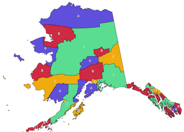
Fig. 24.1 Topological colors example
Parametri
Etichetă |
Nume |
Tipul |
Descriere |
|---|---|---|---|
Strat de intrare |
|
[vector: poligon] |
The input polygon layer |
Minimum number of colors |
|
[numeric: integer] Implicit: 4 |
The minimum number of colors to assign. Minimum 1, maximum 1000. |
Minimum distance between features |
|
[numeric: double] Implicit: 0.0 |
Prevent nearby (but non-touching) features from being assigned equal colors. Minimum 0.0. |
Balance color assignment |
|
[enumerare] Implicit: 0 |
Options are:
|
Colored |
|
[vector: poligon] Implicit: |
Specify the output layer. One of:
The file encoding can also be changed here. |
Rezultat
Etichetă |
Nume |
Tipul |
Descriere |
|---|---|---|---|
Colored |
|
[vector: poligon] |
Polygon vector layer with an added |
Cod Python
Algorithm ID: qgis:topologicalcoloring
import processing
processing.run("algorithm_id", {parameter_dictionary})
ID-ul algoritmului se afișează atunci când treceți peste algoritmul din caseta instrumentelor de procesare. Dicționarul parametrilor furnizează valorile și NUMELE parametrilor. Pentru detalii despre rularea algoritmilor de procesare din consola Python, parcurgeți Utilizarea algoritmilor de procesare din consolă.
24.1.2.14. Transfer annotations from main layer
Transfers all annotations from the main annotation layer in a project to a new annotation layer. Items placement can then be adjusted within the layer stack.
Parametri
Etichetă |
Nume |
Tipul |
Descriere |
|---|---|---|---|
New layer name |
|
[șir] Implicit: «Adnotări» |
Name of the annotations layer to create |
Rezultat
Etichetă |
Nume |
Tipul |
Descriere |
|---|---|---|---|
New layer name |
|
[strat] |
A layer with items from the main annotation layer |
Cod Python
ID algoritm: native:transferannotationsfrommain
import processing
processing.run("algorithm_id", {parameter_dictionary})
ID-ul algoritmului se afișează atunci când treceți peste algoritmul din caseta instrumentelor de procesare. Dicționarul parametrilor furnizează valorile și NUMELE parametrilor. Pentru detalii despre rularea algoritmilor de procesare din consola Python, parcurgeți Utilizarea algoritmilor de procesare din consolă.