Важно
Prevod je zajednički napor :ref:`možete se pridružiti `. Ova stranica je trenutno prevedena na |napredak prevođenja|.
24.1.3. Check Geometry
24.1.3.1. Dangle-end lines
Dodato u 3.42
Detects dangle-end lines in line geometries and reports them as errors. A dangle-end line is a line feature that terminates at a vertex connected to only one segment, resulting in an endpoint without a proper connection.
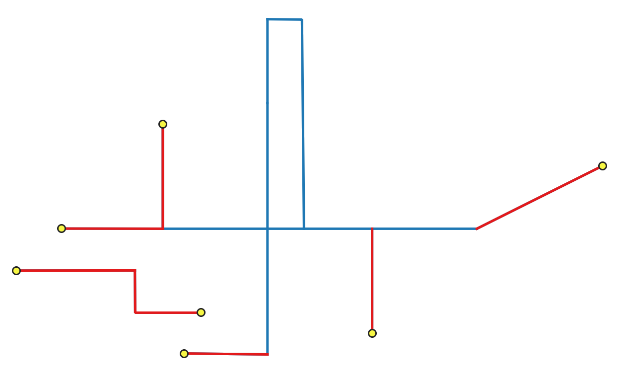
Сл. 24.2 Identifying dangle-end features (in red) and vertices (yellow).
Parametri
Osnovni parametri
Oznaka |
Назив |
Tip |
Opis |
|---|---|---|---|
Ulazni sloj |
|
[vektor: linija] |
Layer with the geometries to check. |
Unique feature identifier |
|
[polje tabele: bilo koji] |
Field storing unique values for feature identification. |
Dangle-end errors |
|
[vektor: tačka] Podrazumevano: |
Specification of the output layer containing the errors location. One of:
Ovde se može promeniti i kodiranje datoteke. |
Dangle-end features Opciono |
|
[vektor: linija] Podrazumevano: |
Line layer containing the identified dangle-end line features. One of:
Ovde se može promeniti i kodiranje datoteke. |
Napredni parametri
Oznaka |
Назив |
Tip |
Opis |
|---|---|---|---|
Tolerancija |
|
[numerički: ceo broj] Podrazumevano: 8 |
Numerical precision of geometric operations, given as an integer n, meaning that two vertices less than 10-n apart (in map units) are considered to be merged. |
Izlazi
Oznaka |
Назив |
Tip |
Opis |
|---|---|---|---|
Dangle-end errors |
|
[vektor: tačka] |
Output point layer representing the error locations and information. The output layer contains the following fields:
|
Dangle-end features |
|
[vektor: linija] |
Output line layer containing the input dangle-end features.
If no dangle-end features are found, the output layer will be empty.
Available fields are the same as in the |
Python kod
Algorithm ID: native:checkgeometrydangle
import processing
processing.run("algorithm_id", {parameter_dictionary})
ID algoritma se prikazuje kada pređete mišem preko algoritma u kutiji sa alatkama Obrade. Rečnik parametara daje NAZIVe i vrednosti parametara. Pogledajte Using processing algorithms from the console za detalje o pokretanju algoritama obrade iz Python konzole.
24.1.3.2. Degenerate polygons
Dodato u 3.42
Checks the polygons with less than 3 points, which are degenerate polygons. Degenerate polygons are errors.
Белешка
This algorithm detects invalid polygon geometries (degenerate polygons).
To ensure these invalid features are not filtered out before processing, open
 Advanced options next to the Input layer and set
Invalid feature filtering to
Advanced options next to the Input layer and set
Invalid feature filtering to Do not Filter (Better Performance).
Parametri
Osnovni parametri
Oznaka |
Назив |
Tip |
Opis |
|---|---|---|---|
Ulazni sloj |
|
[vektor: poligon] |
Layer with the geometries to check. |
Unique feature identifier |
|
[polje tabele: bilo koji] |
Field storing unique values for feature identification. |
Degenerate polygons errors |
|
[vektor: tačka] Podrazumevano: |
Specification of the output layer containing the centroid of the degenerate polygons. One of:
Ovde se može promeniti i kodiranje datoteke. |
Degenerate polygons features Opciono |
|
[vektor: poligon] Podrazumevano: |
Specification of the output layer containing the degenerate polygons. One of:
Ovde se može promeniti i kodiranje datoteke. |
Napredni parametri
Oznaka |
Назив |
Tip |
Opis |
|---|---|---|---|
Tolerancija |
|
[numerički: ceo broj] Podrazumevano: 8 |
Numerical precision of geometric operations, given as an integer n, meaning that two vertices less than 10-n apart (in map units) are considered to be merged. |
Izlazi
Oznaka |
Назив |
Tip |
Opis |
|---|---|---|---|
Degenerate polygons errors |
|
[vektor: tačka] |
Output point layer representing the error locations and information. The output layer contains the following fields:
|
Degenerate polygons features |
|
[vektor: poligon] |
Output polygon layer with features containing the degenerate polygons.
If no degenerate polygon features are found, the output layer will be empty.
Available fields are the same as in the |
Python kod
Algorithm ID: native:checkgeometrydegeneratepolygon
import processing
processing.run("algorithm_id", {parameter_dictionary})
ID algoritma se prikazuje kada pređete mišem preko algoritma u kutiji sa alatkama Obrade. Rečnik parametara daje NAZIVe i vrednosti parametara. Pogledajte Using processing algorithms from the console za detalje o pokretanju algoritama obrade iz Python konzole.
24.1.3.3. Duplicated geometries
Dodato u 3.42
Checks for duplicated geometries in a vector layer, and reports them as errors.
Parametri
Osnovni parametri
Oznaka |
Назив |
Tip |
Opis |
|---|---|---|---|
Ulazni sloj |
|
[vektor: geometrija] |
Layer with the geometries to check |
Unique feature identifier |
|
[polje tabele: bilo koji] |
Field storing unique values for feature identification |
Duplicate geometries errors |
|
[vektor: tačka] Podrazumevano: |
Specification of the output layer containing the errors location. One of:
Ovde se može promeniti i kodiranje datoteke. |
Duplicate geometries Opciono |
|
[vektor: isto kao ulaz] Podrazumevano: |
Specification of the output layer containing the geometries that were found to be duplicated. One of:
Ovde se može promeniti i kodiranje datoteke. |
Napredni parametri
Oznaka |
Назив |
Tip |
Opis |
|---|---|---|---|
Tolerancija |
|
[numerički: ceo broj] Podrazumevano: 8 |
Numerical precision of geometric operations, given as an integer n, meaning that two vertices less than 10-n apart (in map units) are considered to be merged. |
Izlazi
Oznaka |
Назив |
Tip |
Opis |
|---|---|---|---|
Duplicate geometries errors |
|
[vektor: tačka] |
Output point layer representing the error locations and information. The output layer contains the following fields:
|
Duplicate geometries |
|
[vektor: isto kao ulaz] |
Output layer containing the geometries that were found to be duplicated.
Available fields are the same as in the |
Python kod
Algorithm ID: native:checkgeometryduplicate
import processing
processing.run("algorithm_id", {parameter_dictionary})
ID algoritma se prikazuje kada pređete mišem preko algoritma u kutiji sa alatkama Obrade. Rečnik parametara daje NAZIVe i vrednosti parametara. Pogledajte Using processing algorithms from the console za detalje o pokretanju algoritama obrade iz Python konzole.
24.1.3.4. Duplicated vertices
Dodato u 3.42
Checks for duplicated vertices in line or polygon geometries, and reports them as errors.
Parametri
Osnovni parametri
Oznaka |
Назив |
Tip |
Opis |
|---|---|---|---|
Ulazni sloj |
|
[vektor: linija, poligon] |
Layer with the geometries to check |
Unique feature identifier |
|
[polje tabele: bilo koji] |
Field storing unique values for feature identification |
Duplicated vertices errors |
|
[vektor: tačka] Podrazumevano: |
Specification of the output layer containing the errors location. One of:
Ovde se može promeniti i kodiranje datoteke. |
Duplicated vertices features Opciono |
|
[vektor: isto kao ulaz] Podrazumevano: |
Specification of the output layer containing the features with duplicated vertices. One of:
|
Napredni parametri
Oznaka |
Назив |
Tip |
Opis |
|---|---|---|---|
Tolerancija |
|
[numerički: ceo broj] Podrazumevano: 8 |
Numerical precision of geometric operations, given as an integer n, meaning that two vertices less than 10-n apart (in map units) are considered to be merged. |
Izlazi
Oznaka |
Назив |
Tip |
Opis |
|---|---|---|---|
Duplicated vertices errors |
|
[vektor: tačka] |
Output point layer representing the error locations and information. The output layer contains the following fields:
|
Duplicated vertices features |
|
[vektor: isto kao ulaz] |
Output layer containing the features with duplicated vertices.
Available fields are the same as in the |
Python kod
Algorithm ID: native:checkgeometryduplicatenodes
import processing
processing.run("algorithm_id", {parameter_dictionary})
ID algoritma se prikazuje kada pređete mišem preko algoritma u kutiji sa alatkama Obrade. Rečnik parametara daje NAZIVe i vrednosti parametara. Pogledajte Using processing algorithms from the console za detalje o pokretanju algoritama obrade iz Python konzole.
24.1.3.5. Features inside polygon
Dodato u 3.42
Checks the input geometries contained in the polygons from the polygon layers list. A polygon layer can be checked against itself. Any contained features are reported as errors.
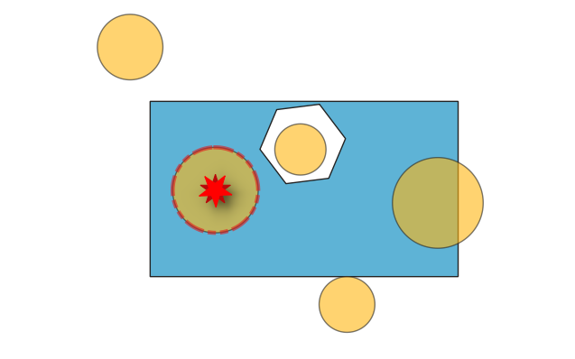
Сл. 24.3 Reporting errors on features inside a polygon.
See also
Parametri
Osnovni parametri
Oznaka |
Назив |
Tip |
Opis |
|---|---|---|---|
Ulazni sloj |
|
[vektor: geometrija] |
Layer with the geometries to check. |
Unique feature identifier |
|
[polje tabele: bilo koji] |
Field storing unique values for feature identification. |
Polygon layers |
|
[vector: polygon][list] |
List of polygon layers to check against. |
Errors from contained features |
|
[vektor: tačka] Podrazumevano: |
Point layer representing the contained features. One of:
Ovde se može promeniti i kodiranje datoteke. |
Contained features Opciono |
|
[vektor: isto kao ulaz] Podrazumevano: |
Specification of the output layer containing features within the checked polygons. One of:
Ovde se može promeniti i kodiranje datoteke. |
Napredni parametri
Oznaka |
Назив |
Tip |
Opis |
|---|---|---|---|
Tolerancija |
|
[numerički: ceo broj] Podrazumevano: 8 |
Numerical precision of geometric operations, given as an integer n, meaning that two vertices less than 10-n apart (in map units) are considered to be merged. |
Izlazi
Oznaka |
Назив |
Tip |
Opis |
|---|---|---|---|
Errors from contained features |
|
[vektor: tačka] |
Output point layer representing the error locations and information. The output layer contains the following fields:
|
Contained features |
|
[vektor: isto kao ulaz] |
Output layer containing features within the checked polygons.
Available fields are the same as in the |
Python kod
Algorithm ID: native:checkgeometrycontained
import processing
processing.run("algorithm_id", {parameter_dictionary})
ID algoritma se prikazuje kada pređete mišem preko algoritma u kutiji sa alatkama Obrade. Rečnik parametara daje NAZIVe i vrednosti parametara. Pogledajte Using processing algorithms from the console za detalje o pokretanju algoritama obrade iz Python konzole.
24.1.3.6. Holes
Dodato u 3.42
Detects holes in polygon geometries and reports them as errors.
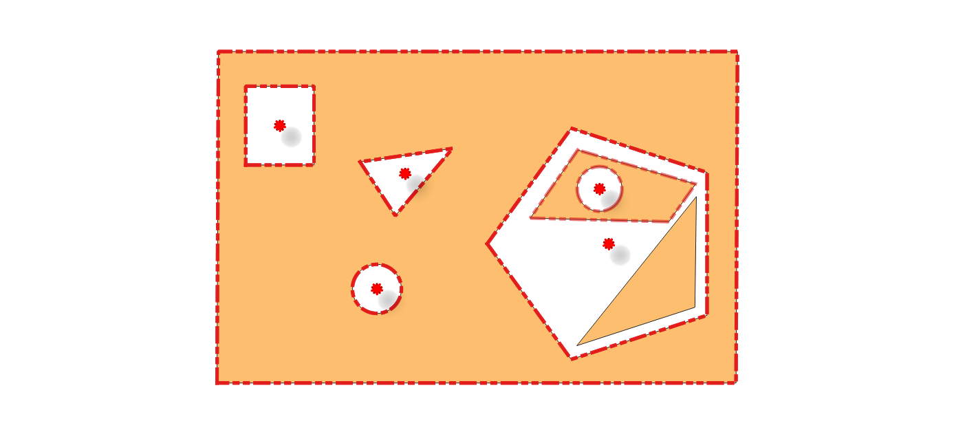
Сл. 24.4 Reporting errors for holes on a polygon feature.
See also
Parametri
Osnovni parametri
Oznaka |
Назив |
Tip |
Opis |
|---|---|---|---|
Ulazni sloj |
|
[vektor: poligon] |
Layer with the geometries to check |
Unique feature identifier |
|
[polje tabele: bilo koji] |
Field storing unique values for feature identification |
Holes errors |
|
[vektor: tačka] Podrazumevano: |
Specification of the output layer containing the errors location. One of:
Ovde se može promeniti i kodiranje datoteke. |
Polygons with holes Opciono |
|
[vektor: poligon] Podrazumevano: |
Polygon layer with the features containing holes. One of:
Ovde se može promeniti i kodiranje datoteke. |
Napredni parametri
Oznaka |
Назив |
Tip |
Opis |
|---|---|---|---|
Tolerancija |
|
[numerički: ceo broj] Podrazumevano: 8 |
Numerical precision of geometric operations, given as an integer n, meaning that two vertices less than 10-n apart (in map units) are considered to be merged. |
Izlazi
Oznaka |
Назив |
Tip |
Opis |
|---|---|---|---|
Holes errors |
|
[vektor: tačka] |
Output point layer representing the error locations and information. The output layer contains the following fields:
|
Polygon with holes |
|
[vektor: poligon] |
Output polygon layer with features containing holes.
If no holes are found, the output layer will be empty.
Available fields are the same as in the |
Python kod
Algorithm ID: native:checkgeometryhole
import processing
processing.run("algorithm_id", {parameter_dictionary})
ID algoritma se prikazuje kada pređete mišem preko algoritma u kutiji sa alatkama Obrade. Rečnik parametara daje NAZIVe i vrednosti parametara. Pogledajte Using processing algorithms from the console za detalje o pokretanju algoritama obrade iz Python konzole.
24.1.3.7. Lines intersecting each other
Dodato u 3.42
Checks intersections between line geometries within a layer. Intersections between two different lines are errors.
See also
Parametri
Osnovni parametri
Oznaka |
Назив |
Tip |
Opis |
|---|---|---|---|
Ulazni sloj |
|
[vektor: linija] |
Layer with the geometries to check. |
Unique feature identifier |
|
[polje tabele: bilo koji] |
Field storing unique values for feature identification. |
Intersection errors |
|
[vektor: tačka] Podrazumevano: |
Specification of the output layer containing the intersections location. One of:
Ovde se može promeniti i kodiranje datoteke. |
Intersecting feature Opciono |
|
[vektor: linija] Podrazumevano: |
Specification of the output layer for features intersecting each other. One of:
Ovde se može promeniti i kodiranje datoteke. |
Napredni parametri
Oznaka |
Назив |
Tip |
Opis |
|---|---|---|---|
Tolerancija |
|
[numerički: ceo broj] Podrazumevano: 8 |
Numerical precision of geometric operations, given as an integer n, meaning that two vertices less than 10-n apart (in map units) are considered to be merged. |
Izlazi
Oznaka |
Назив |
Tip |
Opis |
|---|---|---|---|
Intersection errors |
|
[vektor: tačka] |
Output point layer representing the error locations and information. The output layer contains the following fields:
|
Intersecting feature |
|
[vektor: linija] |
Output layer containing, for each identified intersection, the feature (with same |
Python kod
Algorithm ID: native:checkgeometrylineintersection
import processing
processing.run("algorithm_id", {parameter_dictionary})
ID algoritma se prikazuje kada pređete mišem preko algoritma u kutiji sa alatkama Obrade. Rečnik parametara daje NAZIVe i vrednosti parametara. Pogledajte Using processing algorithms from the console za detalje o pokretanju algoritama obrade iz Python konzole.
24.1.3.8. Lines intersecting other layer
Dodato u 3.42
Checks if the input line layer features intersect with the check layer features. An input feature that intersects with a check layer feature is an error.
See also
Parametri
Osnovni parametri
Oznaka |
Назив |
Tip |
Opis |
|---|---|---|---|
Ulazni sloj |
|
[vektor: linija] |
Layer with the geometries to check. |
Unique feature identifier |
|
[polje tabele: bilo koji] |
Field storing unique values for feature identification. |
Check layer |
|
[vektor: linija, poligon] |
Layer with the geometries to check against. |
Line intersecting other layer errors |
|
[vektor: tačka] Podrazumevano: |
Specification of the output point layer containing the locations of intersection errors. One of:
Ovde se može promeniti i kodiranje datoteke. |
Line intersecting other layer features Opciono |
|
[line] Podrazumevano: |
Line layer with the input features that intersect features in the check layer. One of:
Ovde se može promeniti i kodiranje datoteke. |
Napredni parametri
Oznaka |
Назив |
Tip |
Opis |
|---|---|---|---|
Tolerancija |
|
[numerički: ceo broj] Podrazumevano: 8 |
Numerical precision of geometric operations, given as an integer n, meaning that two vertices less than 10-n apart (in map units) are considered to be merged. |
Izlazi
Oznaka |
Назив |
Tip |
Opis |
|---|---|---|---|
Line intersecting other layer errors |
|
[vektor: tačka] |
Output point layer representing the error location and information. The output layer contains the following fields:
|
Line intersecting other layer features |
|
[vektor: linija] |
Output layer containing, for each identified intersection, the input feature it belongs to.
If no intersections are found, the output layer will be empty.
Available fields are the same as in the |
Python kod
Algorithm ID: native:checkgeometrylinelayerintersection
import processing
processing.run("algorithm_id", {parameter_dictionary})
ID algoritma se prikazuje kada pređete mišem preko algoritma u kutiji sa alatkama Obrade. Rečnik parametara daje NAZIVe i vrednosti parametara. Pogledajte Using processing algorithms from the console za detalje o pokretanju algoritama obrade iz Python konzole.
24.1.3.9. Missing vertices along borders
Dodato u 3.42
Checks for missing vertices along polygon borders. To be topologically correct, a vertex at the junction of two polygons must be present on both polygons. Missing vertices are errors.
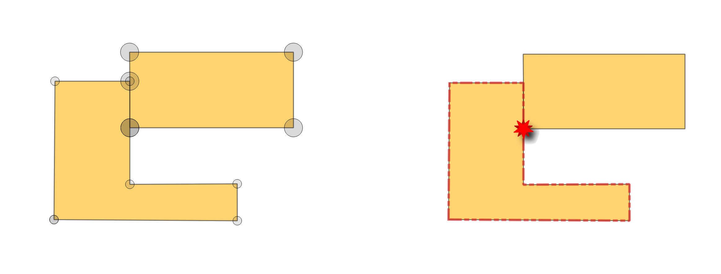
Сл. 24.5 Reporting errors for missing vertices on polygon features.
See also
Parametri
Osnovni parametri
Oznaka |
Назив |
Tip |
Opis |
|---|---|---|---|
Ulazni sloj |
|
[vektor: poligon] |
Layer with the geometries to check. |
Unique feature identifier |
|
[polje tabele: bilo koji] |
Field storing unique values for feature identification. |
Missing vertices errors |
|
[vektor: tačka] Podrazumevano: |
Specification of the output layer containing the errors location. One of:
Ovde se može promeniti i kodiranje datoteke. |
Missing vertices features Opciono |
|
[vektor: poligon] Podrazumevano: |
Polygon layer with the features whose vertices are missing. One of:
Ovde se može promeniti i kodiranje datoteke. |
Napredni parametri
Oznaka |
Назив |
Tip |
Opis |
|---|---|---|---|
Tolerancija |
|
[numerički: ceo broj] Podrazumevano: 8 |
Numerical precision of geometric operations, given as an integer n, meaning that two vertices less than 10-n apart (in map units) are considered to be merged. |
Izlazi
Oznaka |
Назив |
Tip |
Opis |
|---|---|---|---|
Missing vertices errors |
|
[vektor: tačka] |
Output point layer representing the error locations and information. The output layer contains the following fields:
|
Missing vertices features |
|
[vektor: poligon] |
Output polygon layer with features whose vertices are missing.
There will be as many (duplicate) features as there are missing vertices in each geometry.
If no vertices are missing, the output layer will be empty.
Available fields are the same as in the |
Python kod
Algorithm ID: native:checkgeometrymissingvertex
import processing
processing.run("algorithm_id", {parameter_dictionary})
ID algoritma se prikazuje kada pređete mišem preko algoritma u kutiji sa alatkama Obrade. Rečnik parametara daje NAZIVe i vrednosti parametara. Pogledajte Using processing algorithms from the console za detalje o pokretanju algoritama obrade iz Python konzole.
24.1.3.10. Overlaps
Dodato u 3.42
Calculates overlapping areas in polygon geometries, and reports areas smaller than a given minimum as errors.
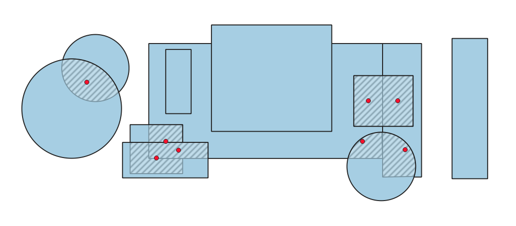
Сл. 24.6 Hashed polygons indicate overlapping areas smaller than the specified minimum.
See also
Parametri
Osnovni parametri
Oznaka |
Назив |
Tip |
Opis |
|---|---|---|---|
Ulazni sloj |
|
[vektor: poligon] |
Layer with the geometries to check. |
Unique feature identifier |
|
[polje tabele: bilo koji] |
Field storing unique values for feature identification. |
Minimum overlap area |
|
[numerički: decimalni] |
Minimum area of the overlap to be reported as an error. If set to 0, all overlaps are reported. |
Overlap errors |
|
[vektor: tačka] Podrazumevano: |
Specification of the output layer containing centroid points of the overlapping areas. One of:
Ovde se može promeniti i kodiranje datoteke. |
Overlap features Opciono |
|
[vektor: poligon] Podrazumevano: |
Specification of the output layer for features containing overlaps. One of:
Ovde se može promeniti i kodiranje datoteke. |
Napredni parametri
Oznaka |
Назив |
Tip |
Opis |
|---|---|---|---|
Tolerancija |
|
[numerički: ceo broj] Podrazumevano: 8 |
Numerical precision of geometric operations, given as an integer n, meaning that two vertices less than 10-n apart (in map units) are considered to be merged. |
Izlazi
Oznaka |
Назив |
Tip |
Opis |
|---|---|---|---|
Overlap errors |
|
[vektor: tačka] |
Output point layer representing the error locations and information. The output layer contains the following fields:
|
Overlap features |
|
[vektor: poligon] |
Output layer containing the overlapping areas.
Available fields are the same as in the |
Python kod
Algorithm ID: native:checkgeometryoverlap
import processing
processing.run("algorithm_id", {parameter_dictionary})
ID algoritma se prikazuje kada pređete mišem preko algoritma u kutiji sa alatkama Obrade. Rečnik parametara daje NAZIVe i vrednosti parametara. Pogledajte Using processing algorithms from the console za detalje o pokretanju algoritama obrade iz Python konzole.
24.1.3.11. Points outside lines
Dodato u 3.42
Checks if the points in the input layer are covered by a line in the selected line layers. A point not covered by a line is an error.
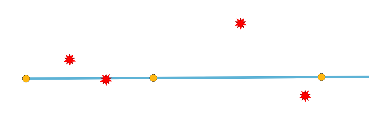
Сл. 24.7 Reporting errors on points not covered by a line.
Parametri
Osnovni parametri
Oznaka |
Назив |
Tip |
Opis |
|---|---|---|---|
Ulazni sloj |
|
[vektor: tačka] |
Layer with the geometries to check. |
Unique feature identifier |
|
[polje tabele: bilo koji] |
Field storing unique values for feature identification. |
Line layers |
|
[vector: line][list] |
Layer(s) with the lines to check against. |
Points not covered by a line |
|
[vektor: tačka] Podrazumevano: |
Specification of the output layer containing points not covered by a line. One of:
Ovde se može promeniti i kodiranje datoteke. |
Napredni parametri
Oznaka |
Назив |
Tip |
Opis |
|---|---|---|---|
Tolerancija |
|
[numerički: ceo broj] Podrazumevano: 8 |
Numerical precision of geometric operations, given as an integer n, meaning that two vertices less than 10-n apart (in map units) are considered to be merged. |
Izlazi
Oznaka |
Назив |
Tip |
Opis |
|---|---|---|---|
Points not covered by a line |
|
[vektor: tačka] |
Output point layer representing the error locations and information. The output layer contains the following fields:
|
Python kod
Algorithm ID: native:checkgeometrypointcoveredbyline
import processing
processing.run("algorithm_id", {parameter_dictionary})
ID algoritma se prikazuje kada pređete mišem preko algoritma u kutiji sa alatkama Obrade. Rečnik parametara daje NAZIVe i vrednosti parametara. Pogledajte Using processing algorithms from the console za detalje o pokretanju algoritama obrade iz Python konzole.
24.1.3.12. Points outside polygons
Dodato u 3.42
Checks if points from the input layer are in polygons from the selected polygon layers. Points that are not fully inside polygons are errors.
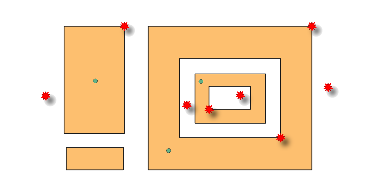
Сл. 24.8 Reporting errors on points outside polygons.
Parametri
Osnovni parametri
Oznaka |
Назив |
Tip |
Opis |
|---|---|---|---|
Ulazni sloj |
|
[vektor: tačka] |
Layer with the geometries to check. |
Unique feature identifier |
|
[polje tabele: bilo koji] |
Field storing unique values for feature identification. |
Polygon layers |
|
[vector: polygon][list] |
Layer(s) with the polygons to check against. |
Points outside polygons errors |
|
[vektor: tačka] Podrazumevano: |
Specification of the output layer containing points outside the polygons. One of:
Ovde se može promeniti i kodiranje datoteke. |
Napredni parametri
Oznaka |
Назив |
Tip |
Opis |
|---|---|---|---|
Tolerancija |
|
[numerički: ceo broj] Podrazumevano: 8 |
Numerical precision of geometric operations, given as an integer n, meaning that two vertices less than 10-n apart (in map units) are considered to be merged. |
Izlazi
Oznaka |
Назив |
Tip |
Opis |
|---|---|---|---|
Points outside polygons errors |
|
[vektor: tačka] |
Output point layer representing the error locations and information. The output layer contains the following fields:
|
Python kod
Algorithm ID: native:checkgeometrypointinpolygon
import processing
processing.run("algorithm_id", {parameter_dictionary})
ID algoritma se prikazuje kada pređete mišem preko algoritma u kutiji sa alatkama Obrade. Rečnik parametara daje NAZIVe i vrednosti parametara. Pogledajte Using processing algorithms from the console za detalje o pokretanju algoritama obrade iz Python konzole.
24.1.3.13. Self-contacts
Dodato u 3.42
Checks if the geometry has self contact points (in line or polygon), i.e., a vertex that touches more than two segments of the same ring. Self contacts are errors.
Белешка
This algorithm detects invalid polygon geometries (self-contacts).
To ensure these invalid features are not filtered out before processing, open
Advanced options next to the Input layer and set
Invalid feature filtering to Do not Filter (Better Performance).
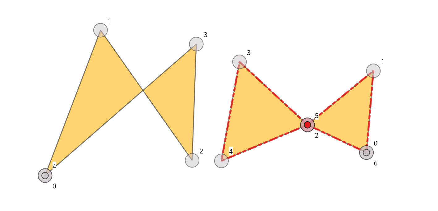
Сл. 24.9 Self-intersection vs self-contact.
See also
Parametri
Osnovni parametri
Oznaka |
Назив |
Tip |
Opis |
|---|---|---|---|
Ulazni sloj |
|
[vektor: linija, poligon] |
Layer with the geometries to check. |
Unique feature identifier |
|
[polje tabele: bilo koji] |
Field storing unique values for feature identification. |
Self contact error points |
|
[vektor: tačka] Podrazumevano: |
Specification of the output layer containing the errors location. One of:
Ovde se može promeniti i kodiranje datoteke. |
Self contact features Opciono |
|
[isto kao ulaz] Podrazumevano: |
Line or polygon layer containing self-contact features. One of:
Ovde se može promeniti i kodiranje datoteke. |
Napredni parametri
Oznaka |
Назив |
Tip |
Opis |
|---|---|---|---|
Tolerancija |
|
[numerički: ceo broj] Podrazumevano: 8 |
Numerical precision of geometric operations, given as an integer n, meaning that two vertices less than 10-n apart (in map units) are considered to be merged. |
Izlazi
Oznaka |
Назив |
Tip |
Opis |
|---|---|---|---|
Self contact error points |
|
[vektor: tačka] |
Output point layer representing the error locations and information. The output layer contains the following fields:
|
Self contact features |
|
[vektor: isto kao ulaz] |
Output polygon or line layer with features containing the self-contact features.
If no self-contact features are found, the output layer will be empty.
Available fields are the same as in the |
Python kod
Algorithm ID: native:checkgeometryselfcontact
import processing
processing.run("algorithm_id", {parameter_dictionary})
ID algoritma se prikazuje kada pređete mišem preko algoritma u kutiji sa alatkama Obrade. Rečnik parametara daje NAZIVe i vrednosti parametara. Pogledajte Using processing algorithms from the console za detalje o pokretanju algoritama obrade iz Python konzole.
24.1.3.14. Self-intersections
Dodato u 3.42
Detects self-intersections in line or polygon geometries, and reports them as errors. Self-intersections occur when the segments of a geometry cross over each other without having a common vertex.
Белешка
This algorithm detects invalid polygon geometries (self-intersections).
To ensure these invalid features are not filtered out before processing, open
Advanced options next to the Input layer and set
Invalid feature filtering to Do not Filter (Better Performance).
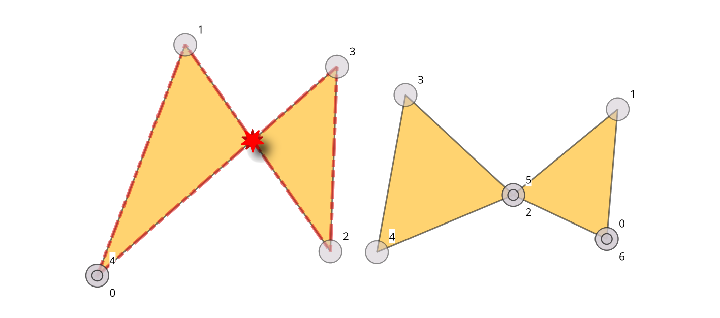
Сл. 24.10 Self-intersection vs self-contact.
Parametri
Osnovni parametri
Oznaka |
Назив |
Tip |
Opis |
|---|---|---|---|
Ulazni sloj |
|
[vektor: linija, poligon] |
Layer with the geometries to check |
Unique feature identifier |
|
[polje tabele: bilo koji] |
Field storing unique values for feature identification |
Self-intersecting errors |
|
[vektor: tačka] Podrazumevano: |
Specification of the output layer containing the errors location. One of:
Ovde se može promeniti i kodiranje datoteke. |
Self-intersecting features Opciono |
|
[isto kao ulaz] Podrazumevano: |
Line or polygon layer containing self-intersected features. One of:
Ovde se može promeniti i kodiranje datoteke. |
Napredni parametri
Oznaka |
Назив |
Tip |
Opis |
|---|---|---|---|
Tolerancija |
|
[numerički: ceo broj] Podrazumevano: 8 |
Numerical precision of geometric operations, given as an integer n, meaning that two vertices less than 10-n apart (in map units) are considered to be merged. |
Izlazi
Oznaka |
Назив |
Tip |
Opis |
|---|---|---|---|
Self-intersecting errors |
|
[vektor: tačka] |
Output point layer representing the error locations and information. The output layer contains the following fields:
|
Self-intersecting features |
|
[vektor: linija, poligon] |
Output polygon or line layer with features containing the self-intersecting features.
If no self-intersecting features are found, the output layer will be empty.
Available fields are the same as in the |
Python kod
Algorithm ID: native:checkgeometryselfintersection
import processing
processing.run("algorithm_id", {parameter_dictionary})
ID algoritma se prikazuje kada pređete mišem preko algoritma u kutiji sa alatkama Obrade. Rečnik parametara daje NAZIVe i vrednosti parametara. Pogledajte Using processing algorithms from the console za detalje o pokretanju algoritama obrade iz Python konzole.
24.1.3.15. Sliver polygons
Dodato u 3.42
Detects sliver polygons in a polygon layer, i.e., polygons with a thinness greater than a specified value.
The thinness is the ratio between the area of the minimum square containing the polygon and the area of the polygon itself (a square has a thinness value of 1). The thinness value is between 1 and +infinity. A maximum area can be set for limiting the checks to polygons of a lower area. Polygons having a thinness higher than the maximum thinness are errors. To fix sliver polygons, use the Fix small polygons algorithm.
Белешка
This algorithm detects invalid polygon geometries (sliver polygons).
To ensure these invalid features are not filtered out before processing, open
Advanced options next to the Input layer and set
Invalid feature filtering to Do not Filter (Better Performance).
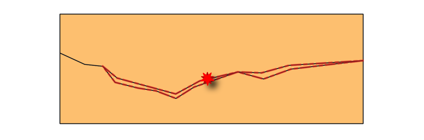
Сл. 24.11 Reporting errors on features with sliver polygons.
See also
Parametri
Osnovni parametri
Oznaka |
Назив |
Tip |
Opis |
|---|---|---|---|
Ulazni sloj |
|
[vektor: poligon] |
Layer with the geometries to check. |
Unique feature identifier |
|
[polje tabele: bilo koji] |
Field storing unique values for feature identification. |
Maximum thinness |
|
[numerički: decimalni] Default: 20.0 |
Maximum thinness value of a polygon to be considered valid. Any polygon with a thinness value above this threshold is reported as error. |
Maximum area (map units squared) |
|
[numerički: decimalni] Podrazumevano: 0.0 |
Maximum area of a polygon to be checked (in map units). Any polygon with an area above this threshold is skipped. A value of 0 means all polygons are checked. |
Sliver polygon errors |
|
[vektor: tačka] Podrazumevano: |
Specification of the output layer containing the centroid points of sliver polygon features. One of:
Ovde se može promeniti i kodiranje datoteke. |
Sliver polygon features Opciono |
|
[vektor: poligon] Podrazumevano: |
Polygon layer containing sliver polygon features. One of:
Ovde se može promeniti i kodiranje datoteke. |
Napredni parametri
Oznaka |
Назив |
Tip |
Opis |
|---|---|---|---|
Tolerancija |
|
[numerički: ceo broj] Podrazumevano: 8 |
Numerical precision of geometric operations, given as an integer n, meaning that two vertices less than 10-n apart (in map units) are considered to be merged. |
Izlazi
Oznaka |
Назив |
Tip |
Opis |
|---|---|---|---|
Sliver polygon errors |
|
[vektor: tačka] |
Output point layer representing the error locations and information. The output layer contains the following fields:
|
Sliver polygon features |
|
[vektor: poligon] |
Output layer with features containing the sliver polygons.
If no sliver polygon features are found, the output layer will be empty.
Available fields are the same as in the |
Python kod
Algorithm ID: native:checkgeometrysliverpolygon
import processing
processing.run("algorithm_id", {parameter_dictionary})
ID algoritma se prikazuje kada pređete mišem preko algoritma u kutiji sa alatkama Obrade. Rečnik parametara daje NAZIVe i vrednosti parametara. Pogledajte Using processing algorithms from the console za detalje o pokretanju algoritama obrade iz Python konzole.
24.1.3.16. Small angles
Dodato u 3.42
Compares the angles within line or polygon geometries to a specified threshold, and reports as error any angle below that value.
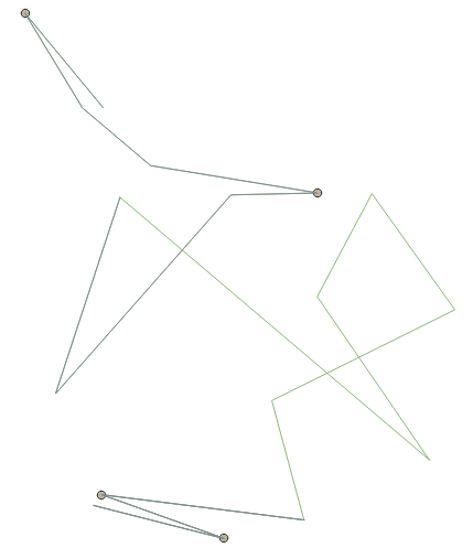
Сл. 24.12 Reporting errors on a line feature for angles lower than 15°.
See also
Parametri
Osnovni parametri
Oznaka |
Назив |
Tip |
Opis |
|---|---|---|---|
Ulazni sloj |
|
[vektor: linija, poligon] |
Layer with the geometries to check. |
Unique feature identifier |
|
[polje tabele: bilo koji] |
Field storing unique values for feature identification. |
Minimum angle |
|
[numerički: decimalni] |
Allowed minimum angle between adjacent segments in a feature’s geometry. Any angle below this threshold is reported as error. |
Small angle errors |
|
[vektor: tačka] Podrazumevano: |
Specification of the output layer containing the errors location. One of:
Ovde se može promeniti i kodiranje datoteke. |
Napredni parametri
Oznaka |
Назив |
Tip |
Opis |
|---|---|---|---|
Tolerancija |
|
[numerički: ceo broj] Podrazumevano: 8 |
Numerical precision of geometric operations, given as an integer n, meaning that two vertices less than 10-n apart (in map units) are considered to be merged. |
Izlazi
Oznaka |
Назив |
Tip |
Opis |
|---|---|---|---|
Small angle errors |
|
[vektor: tačka] |
Output point layer representing the error locations and information. The output layer contains the following fields:
|
Python kod
Algorithm ID: native:checkgeometryangle
import processing
processing.run("algorithm_id", {parameter_dictionary})
ID algoritma se prikazuje kada pređete mišem preko algoritma u kutiji sa alatkama Obrade. Rečnik parametara daje NAZIVe i vrednosti parametara. Pogledajte Using processing algorithms from the console za detalje o pokretanju algoritama obrade iz Python konzole.
24.1.3.17. Small polygons
Dodato u 3.42
Detects polygon features whose area is below a specified value as errors.
Белешка
This algorithm detects invalid polygon geometries (small polygons).
To ensure these invalid features are not filtered out before processing, open
Advanced options next to the Input layer and set
Invalid feature filtering to Do not Filter (Better Performance).
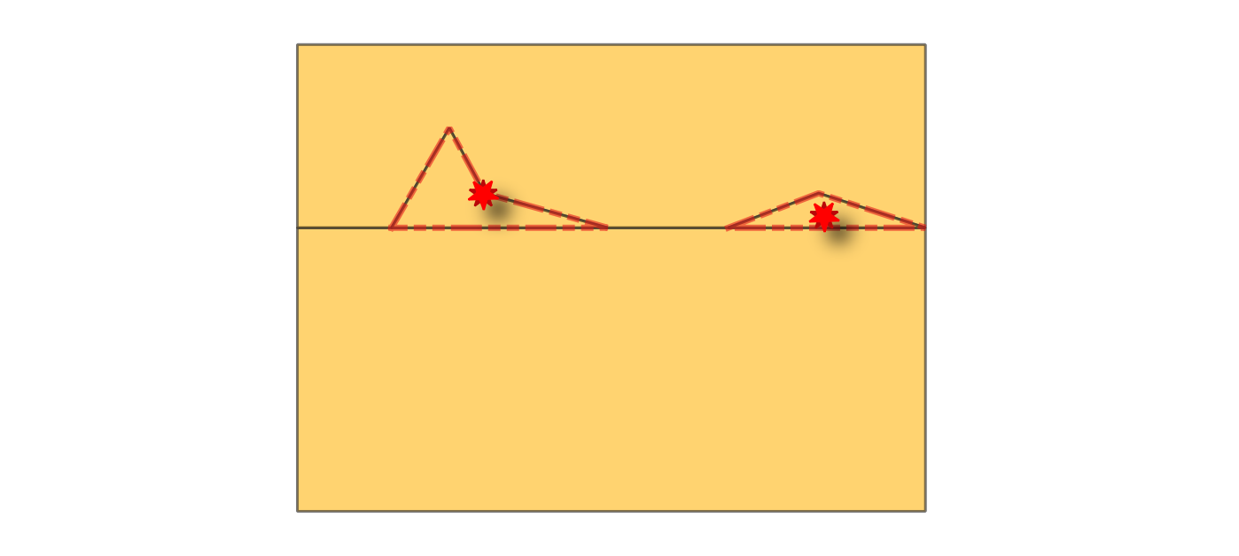
Сл. 24.13 Reporting errors on features with small polygons (below given area threshold).
See also
Parametri
Osnovni parametri
Oznaka |
Назив |
Tip |
Opis |
|---|---|---|---|
Ulazni sloj |
|
[vektor: poligon] |
Layer with the geometries to check. |
Unique feature identifier |
|
[polje tabele: bilo koji] |
Field storing unique values for feature identification. |
Area threshold |
|
[numerički: decimalni] Podrazumevano: 0 |
Minimum area of a polygon to be considered valid, in selected units. Any polygon with an area below this threshold is reported as error. |
Small polygons errors |
|
[vektor: tačka] Podrazumevano: |
Specification of the output layer containing centroid points of small polygons. One of:
Ovde se može promeniti i kodiranje datoteke. |
Small polygons features Opciono |
|
[vektor: poligon] Podrazumevano: |
Specification of the output layer for features containing small polygon features. One of:
Ovde se može promeniti i kodiranje datoteke. |
Napredni parametri
Oznaka |
Назив |
Tip |
Opis |
|---|---|---|---|
Tolerancija |
|
[numerički: ceo broj] Podrazumevano: 8 |
Numerical precision of geometric operations, given as an integer n, meaning that two vertices less than 10-n apart (in map units) are considered to be merged. |
Izlazi
Oznaka |
Назив |
Tip |
Opis |
|---|---|---|---|
Small polygons errors |
|
[vektor: tačka] |
Output point layer representing the error locations and information. The output layer contains the following fields:
|
Small polygons features |
|
[vektor: poligon] |
Output polygon layer with features containing the small polygon features.
If no small polygon features are found, the output layer will be empty.
Available fields are the same as in the |
Python kod
Algorithm ID: native:checkgeometryarea
import processing
processing.run("algorithm_id", {parameter_dictionary})
ID algoritma se prikazuje kada pređete mišem preko algoritma u kutiji sa alatkama Obrade. Rečnik parametara daje NAZIVe i vrednosti parametara. Pogledajte Using processing algorithms from the console za detalje o pokretanju algoritama obrade iz Python konzole.
24.1.3.18. Small gaps
Dodato u 3.42
Checks for gaps between polygons in the input layer. Gaps with an area smaller than the gap threshold are reported as errors. If an allowed gaps layer is provided, the algorithm ignores gaps that fall entirely within polygons from this layer. An optional buffer can be applied to the allowed gaps.
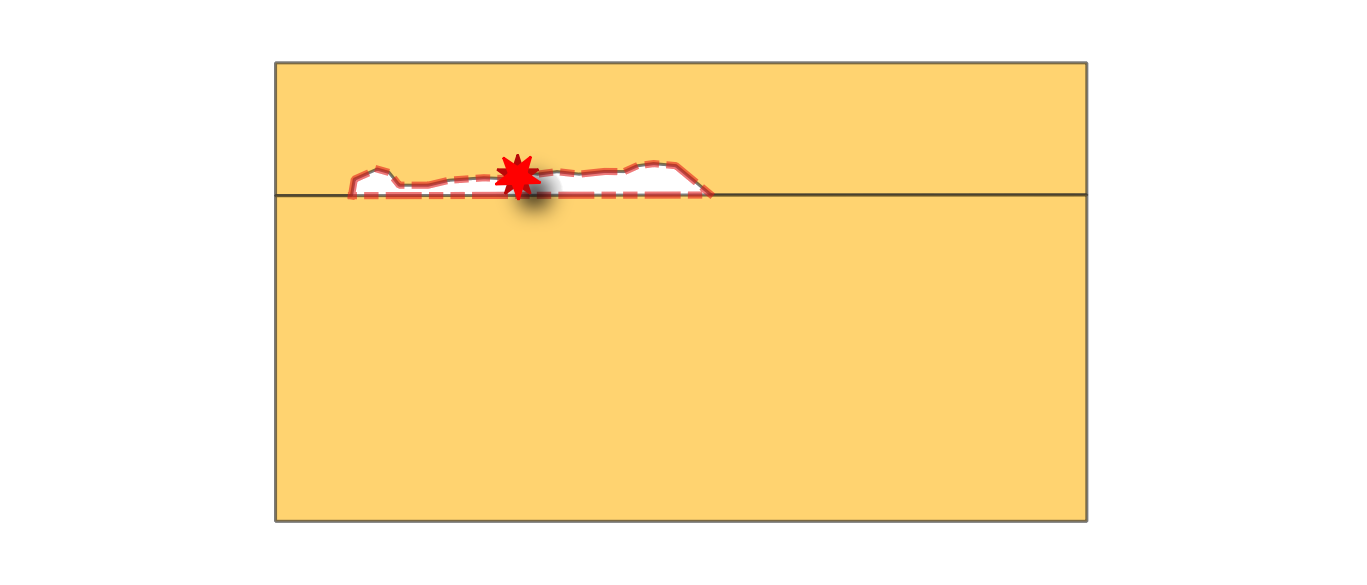
Сл. 24.14 Reporting errors on polygon features for gaps smaller than the specified threshold.
See also
Parametri
Osnovni parametri
Oznaka |
Назив |
Tip |
Opis |
|---|---|---|---|
Ulazni sloj |
|
[vektor: poligon] |
Layer with the geometries to check. |
Unique feature identifier |
|
[polje tabele: bilo koji] |
Field storing unique values for feature identification. |
Gap threshold |
|
[numerički: decimalni] Podrazumevano: 0.0 |
Maximum area of gaps to be reported as errors, in map units. If set to 0, all the gaps are reported. |
Allowed gaps layer Opciono |
|
[vektor: poligon] |
Optional layer specifying polygons whose areas should be ignored during the gap check. Gaps that fall entirely within these polygons will not be reported as errors. |
Allowed gaps buffer Opciono |
|
[numerički: decimalni] Podrazumevano: 0.0 |
Buffer distance to apply to the allowed gaps layer, in selected units. Gaps located within this buffered area are ignored. Allows adding a spatial tolerance around allowed gaps to avoid reporting near-boundary gaps as errors. |
Neighbors layer |
|
[vektor: tabela] Podrazumevano: |
Specification of the output table representing the gap ID and the unique ID of its neighbor features. One of:
Ovde se može promeniti i kodiranje datoteke. |
Gap errors Opciono |
|
[vektor: tačka] Podrazumevano: |
Specification of the output layer containing the centroid points of the gaps. One of:
Ovde se može promeniti i kodiranje datoteke. |
Gap features |
|
[vektor: poligon] Podrazumevano: |
Specification of the output layer containing the gap geometries. One of:
Ovde se može promeniti i kodiranje datoteke. |
Napredni parametri
Oznaka |
Назив |
Tip |
Opis |
|---|---|---|---|
Tolerancija |
|
[numerički: ceo broj] Podrazumevano: 8 |
Numerical precision of geometric operations, given as an integer n, meaning that two vertices less than 10-n apart (in map units) are considered to be merged. |
Izlazi
Oznaka |
Назив |
Tip |
Opis |
|---|---|---|---|
Neighbors layer |
|
[vektor: tabela] |
A 1–N relational table, meaning that one gap can be associated with multiple neighboring polygons. The output table contains the following fields:
|
Gap errors |
|
[vektor: tačka] |
Output point layer representing the error locations and information. The output layer contains the following fields:
|
Gap features |
|
[vektor: poligon] |
Output layer containing the gap geometries.
Available fields are the same as in the |
Python kod
Algorithm ID: native:checkgeometrygap
import processing
processing.run("algorithm_id", {parameter_dictionary})
ID algoritma se prikazuje kada pređete mišem preko algoritma u kutiji sa alatkama Obrade. Rečnik parametara daje NAZIVe i vrednosti parametara. Pogledajte Using processing algorithms from the console za detalje o pokretanju algoritama obrade iz Python konzole.
24.1.3.19. Small segments
Dodato u 3.42
Calculates length of individual segments in line or polygon geometries, and reports segments shorter than a minimum length as errors.
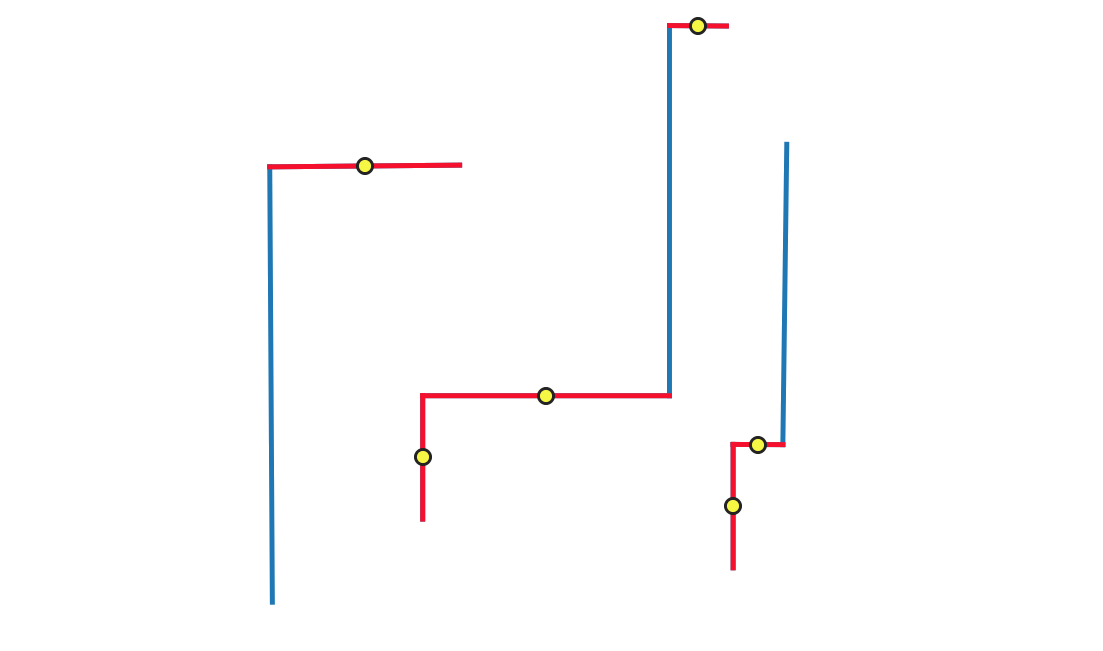
Сл. 24.15 Reporting errors (in red) on single line segments shorter than the given threshold.
See also
Parametri
Osnovni parametri
Oznaka |
Назив |
Tip |
Opis |
|---|---|---|---|
Ulazni sloj |
|
[vektor: linija, poligon] |
Layer with the geometries to check. |
Unique feature identifier |
|
[polje tabele: bilo koji] |
Field storing unique values for feature identification. |
Minimum segment length |
|
[numerički: decimalni] Podrazumevano: 0.0 |
Minimum length of segments to be considered valid, in map units. |
Short segments errors |
|
[vektor: tačka] Podrazumevano: |
Specification of the output layer containing centroid of short segments. One of:
Ovde se može promeniti i kodiranje datoteke. |
Short segments features Opciono |
|
[vektor: isto kao ulaz] Podrazumevano: |
Specification of the output layer for features containing short segments. One of:
Ovde se može promeniti i kodiranje datoteke. |
Napredni parametri
Oznaka |
Назив |
Tip |
Opis |
|---|---|---|---|
Tolerancija |
|
[numerički: ceo broj] Podrazumevano: 8 |
Numerical precision of geometric operations, given as an integer n, meaning that two vertices less than 10-n apart (in map units) are considered to be merged. |
Izlazi
Oznaka |
Назив |
Tip |
Opis |
|---|---|---|---|
Short segments errors |
|
[vektor: tačka] |
Output point layer representing the error locations and information. The output layer contains the following fields:
|
Short segments features |
|
[vektor: isto kao ulaz] |
Output layer containing, for each identified short segment, the feature it belongs to.
Available fields are the same as in the |
Python kod
Algorithm ID: native:checkgeometrysegmentlength
import processing
processing.run("algorithm_id", {parameter_dictionary})
ID algoritma se prikazuje kada pređete mišem preko algoritma u kutiji sa alatkama Obrade. Rečnik parametara daje NAZIVe i vrednosti parametara. Pogledajte Using processing algorithms from the console za detalje o pokretanju algoritama obrade iz Python konzole.
24.1.3.20. Strictly multipart
Dodato u 3.42
Checks if multipart geometries have more than one part. Multipart geometries with only one part are errors.
See also
Parametri
Osnovni parametri
Oznaka |
Назив |
Tip |
Opis |
|---|---|---|---|
Ulazni sloj |
|
[vektor: geometrija] |
Layer with the geometries to check. |
Unique feature identifier |
|
[polje tabele: bilo koji] |
Field storing unique values for feature identification. |
One-part geometry errors |
|
[vektor: tačka] Podrazumevano: |
Specification of the output layer containing centroid of the multipart geometries that have only one part. One of:
Ovde se može promeniti i kodiranje datoteke. |
One-part geometry features Opciono |
|
[vektor: isto kao ulaz] Podrazumevano: |
Specification of the output layer for features containing multipart geometries that have only one part. One of:
Ovde se može promeniti i kodiranje datoteke. |
Napredni parametri
Oznaka |
Назив |
Tip |
Opis |
|---|---|---|---|
Tolerancija |
|
[numerički: ceo broj] Podrazumevano: 8 |
Numerical precision of geometric operations, given as an integer n, meaning that two vertices less than 10-n apart (in map units) are considered to be merged. |
Izlazi
Oznaka |
Назив |
Tip |
Opis |
|---|---|---|---|
One-part geometry errors |
|
[vektor: tačka] |
Output point layer representing the error locations and information. The output layer contains the following fields:
|
One-part geometry features |
|
[vektor: isto kao ulaz] |
Output layer containing features that are multipart but have only one part.
Available fields are the same as in the |
Python kod
Algorithm ID: native:checkgeometrymultipart
import processing
processing.run("algorithm_id", {parameter_dictionary})
ID algoritma se prikazuje kada pređete mišem preko algoritma u kutiji sa alatkama Obrade. Rečnik parametara daje NAZIVe i vrednosti parametara. Pogledajte Using processing algorithms from the console za detalje o pokretanju algoritama obrade iz Python konzole.