Importante
La traduzione è uno sforzo comunitario you can join. Questa pagina è attualmente tradotta al 71.09%.
24.1.3. Verificare Geometria
24.1.3.1. Dangle-end lines
Aggiunto nella versione 3.42
Detects dangle-end lines in line geometries and reports them as errors. A dangle-end line is a line feature that terminates at a vertex connected to only one segment, resulting in an endpoint without a proper connection.
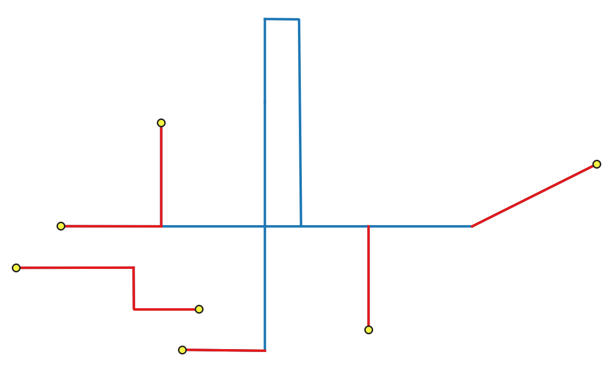
Fig. 24.2 Identifying dangle-end features (in red) and vertices (yellow).
Parametri
Parametri di base
Etichetta |
Nome |
Tipo |
Descrizione |
|---|---|---|---|
Layer in ingresso |
|
[vector: line] |
Layer with the geometries to check. |
Unique feature identifier |
|
[tablefield: any] |
Field storing unique values for feature identification. |
Dangle-end errors |
|
[vector: point] Predefinito: |
Specification of the output layer containing the errors location. One of:
La codifica del file può anche essere cambiata qui. |
Dangle-end features Opzionale |
|
[vector: line] Predefinito: |
Line layer containing the identified dangle-end line features. One of:
La codifica del file può anche essere cambiata qui. |
Parametri avanzati
Etichetta |
Nome |
Tipo |
Descrizione |
|---|---|---|---|
Tolleranza |
|
[numeric: integer] Predefinito: 8 |
Numerical precision of geometric operations, given as an integer n, meaning that two vertices less than 10-n apart (in map units) are considered to be merged. |
In uscita:
Etichetta |
Nome |
Tipo |
Descrizione |
|---|---|---|---|
Dangle-end errors |
|
[vector: point] |
Output point layer representing the error locations and information. The output layer contains the following fields:
|
Dangle-end features |
|
[vector: line] |
Output line layer containing the input dangle-end features.
If no dangle-end features are found, the output layer will be empty.
Available fields are the same as in the |
Codice Python
ID algoritmo: native:checkgeometrydangle
import processing
processing.run("algorithm_id", {parameter_dictionary})
L” id dell’algoritmo viene visualizzato quando si passa il mouse sull’algoritmo nella finestra degli strumenti di elaborazione. Il dizionario dei parametri fornisce i Nomi e i valori dei parametri. Vedi Usare gli algoritmi di Processing dalla console dei comandi per dettagli su come eseguire algoritmi di elaborazione dalla console Python.
24.1.3.2. Degenerate polygons
Aggiunto nella versione 3.42
Checks the polygons with less than 3 points, which are degenerate polygons. Degenerate polygons are errors.
Nota
This algorithm detects invalid polygon geometries (degenerate polygons).
To ensure these invalid features are not filtered out before processing, open
 Advanced options next to the Input layer and set
Invalid feature filtering to
Advanced options next to the Input layer and set
Invalid feature filtering to Do not Filter (Better Performance).
Parametri
Parametri di base
Etichetta |
Nome |
Tipo |
Descrizione |
|---|---|---|---|
Layer in ingresso |
|
[vector: polygon] |
Layer with the geometries to check. |
Unique feature identifier |
|
[tablefield: any] |
Field storing unique values for feature identification. |
Degenerate polygons errors |
|
[vector: point] Predefinito: |
Specification of the output layer containing the centroid of the degenerate polygons. One of:
La codifica del file può anche essere cambiata qui. |
Degenerate polygons features Opzionale |
|
[vector: polygon] Predefinito: |
Specification of the output layer containing the degenerate polygons. One of:
La codifica del file può anche essere cambiata qui. |
Parametri avanzati
Etichetta |
Nome |
Tipo |
Descrizione |
|---|---|---|---|
Tolleranza |
|
[numeric: integer] Predefinito: 8 |
Numerical precision of geometric operations, given as an integer n, meaning that two vertices less than 10-n apart (in map units) are considered to be merged. |
In uscita:
Etichetta |
Nome |
Tipo |
Descrizione |
|---|---|---|---|
Degenerate polygons errors |
|
[vector: point] |
Output point layer representing the error locations and information. The output layer contains the following fields:
|
Degenerate polygons features |
|
[vector: polygon] |
Output polygon layer with features containing the degenerate polygons.
If no degenerate polygon features are found, the output layer will be empty.
Available fields are the same as in the |
Codice Python
ID algoritmo: native:checkgeometrydegeneratepolygon
import processing
processing.run("algorithm_id", {parameter_dictionary})
L” id dell’algoritmo viene visualizzato quando si passa il mouse sull’algoritmo nella finestra degli strumenti di elaborazione. Il dizionario dei parametri fornisce i Nomi e i valori dei parametri. Vedi Usare gli algoritmi di Processing dalla console dei comandi per dettagli su come eseguire algoritmi di elaborazione dalla console Python.
24.1.3.3. Duplicated geometries
Aggiunto nella versione 3.42
Checks for duplicated geometries in a vector layer, and reports them as errors.
Parametri
Parametri di base
Etichetta |
Nome |
Tipo |
Descrizione |
|---|---|---|---|
Layer in ingresso |
|
[vector: geometry] |
Layer with the geometries to check |
Unique feature identifier |
|
[tablefield: any] |
Field storing unique values for feature identification |
Duplicate geometries errors |
|
[vector: point] Predefinito: |
Specification of the output layer containing the errors location. One of:
La codifica del file può anche essere cambiata qui. |
Duplicate geometries Opzionale |
|
[vector: same as input] Predefinito: |
Specification of the output layer containing the geometries that were found to be duplicated. One of:
La codifica del file può anche essere cambiata qui. |
Parametri avanzati
Etichetta |
Nome |
Tipo |
Descrizione |
|---|---|---|---|
Tolleranza |
|
[numeric: integer] Predefinito: 8 |
Numerical precision of geometric operations, given as an integer n, meaning that two vertices less than 10-n apart (in map units) are considered to be merged. |
In uscita:
Etichetta |
Nome |
Tipo |
Descrizione |
|---|---|---|---|
Duplicate geometries errors |
|
[vector: point] |
Output point layer representing the error locations and information. The output layer contains the following fields:
|
Duplicate geometries |
|
[vector: same as input] |
Output layer containing the geometries that were found to be duplicated.
Available fields are the same as in the |
Codice Python
ID algoritmo: native:checkgeometryduplicate
import processing
processing.run("algorithm_id", {parameter_dictionary})
L” id dell’algoritmo viene visualizzato quando si passa il mouse sull’algoritmo nella finestra degli strumenti di elaborazione. Il dizionario dei parametri fornisce i Nomi e i valori dei parametri. Vedi Usare gli algoritmi di Processing dalla console dei comandi per dettagli su come eseguire algoritmi di elaborazione dalla console Python.
24.1.3.4. Vertici duplicati
Aggiunto nella versione 3.42
Checks for duplicated vertices in line or polygon geometries, and reports them as errors.
Vedi anche
Parametri
Parametri di base
Etichetta |
Nome |
Tipo |
Descrizione |
|---|---|---|---|
Layer in ingresso |
|
[vector: line, polygon] |
Layer with the geometries to check |
Unique feature identifier |
|
[tablefield: any] |
Field storing unique values for feature identification |
Duplicated vertices errors |
|
[vector: point] Predefinito: |
Specification of the output layer containing the errors location. One of:
La codifica del file può anche essere cambiata qui. |
Duplicated vertices features Opzionale |
|
[vector: same as input] Predefinito: |
Specification of the output layer containing the features with duplicated vertices. One of:
|
Parametri avanzati
Etichetta |
Nome |
Tipo |
Descrizione |
|---|---|---|---|
Tolleranza |
|
[numeric: integer] Predefinito: 8 |
Numerical precision of geometric operations, given as an integer n, meaning that two vertices less than 10-n apart (in map units) are considered to be merged. |
In uscita:
Etichetta |
Nome |
Tipo |
Descrizione |
|---|---|---|---|
Duplicated vertices errors |
|
[vector: point] |
Output point layer representing the error locations and information. The output layer contains the following fields:
|
Duplicated vertices features |
|
[vector: same as input] |
Output layer containing the features with duplicated vertices.
Available fields are the same as in the |
Codice Python
ID algoritmo: native:checkgeometryduplicatenodes
import processing
processing.run("algorithm_id", {parameter_dictionary})
L” id dell’algoritmo viene visualizzato quando si passa il mouse sull’algoritmo nella finestra degli strumenti di elaborazione. Il dizionario dei parametri fornisce i Nomi e i valori dei parametri. Vedi Usare gli algoritmi di Processing dalla console dei comandi per dettagli su come eseguire algoritmi di elaborazione dalla console Python.
24.1.3.5. Features inside polygon
Aggiunto nella versione 3.42
Checks the input geometries contained in the polygons from the polygon layers list. A polygon layer can be checked against itself. Any contained features are reported as errors.
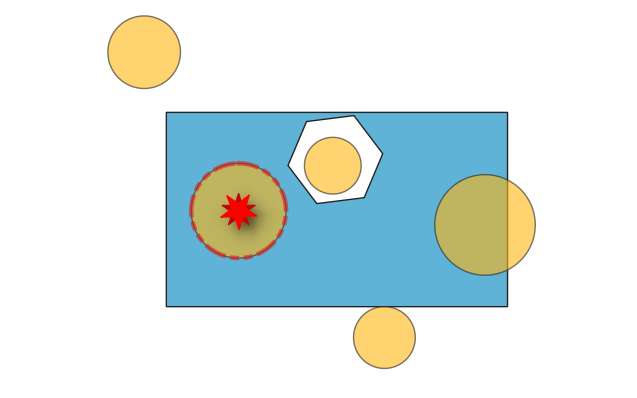
Fig. 24.3 Reporting errors on features inside a polygon.
Vedi anche
Parametri
Parametri di base
Etichetta |
Nome |
Tipo |
Descrizione |
|---|---|---|---|
Layer in ingresso |
|
[vector: geometry] |
Layer with the geometries to check. |
Unique feature identifier |
|
[tablefield: any] |
Field storing unique values for feature identification. |
Polygon layers |
|
[vector: polygon][list] |
List of polygon layers to check against. |
Errors from contained features |
|
[vector: point] Predefinito: |
Point layer representing the contained features. One of:
La codifica del file può anche essere cambiata qui. |
Contained features Opzionale |
|
[vector: same as input] Predefinito: |
Specification of the output layer containing features within the checked polygons. One of:
La codifica del file può anche essere cambiata qui. |
Parametri avanzati
Etichetta |
Nome |
Tipo |
Descrizione |
|---|---|---|---|
Tolleranza |
|
[numeric: integer] Predefinito: 8 |
Numerical precision of geometric operations, given as an integer n, meaning that two vertices less than 10-n apart (in map units) are considered to be merged. |
In uscita:
Etichetta |
Nome |
Tipo |
Descrizione |
|---|---|---|---|
Errors from contained features |
|
[vector: point] |
Output point layer representing the error locations and information. The output layer contains the following fields:
|
Contained features |
|
[vector: same as input] |
Output layer containing features within the checked polygons.
Available fields are the same as in the |
Codice Python
ID algoritmo: native:checkgeometrycontained
import processing
processing.run("algorithm_id", {parameter_dictionary})
L” id dell’algoritmo viene visualizzato quando si passa il mouse sull’algoritmo nella finestra degli strumenti di elaborazione. Il dizionario dei parametri fornisce i Nomi e i valori dei parametri. Vedi Usare gli algoritmi di Processing dalla console dei comandi per dettagli su come eseguire algoritmi di elaborazione dalla console Python.
24.1.3.6. Buchi
Aggiunto nella versione 3.42
Rileva i buchi nelle geometrie poligono e li segnala come errori.
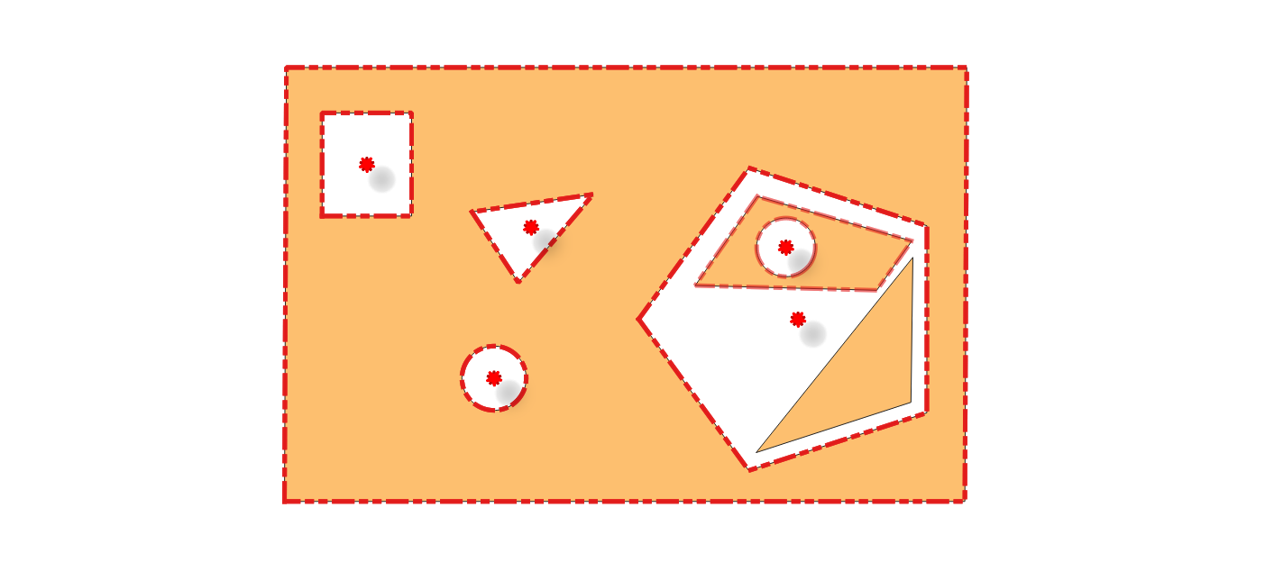
Fig. 24.4 Reporting errors for holes on a polygon feature.
Vedi anche
Parametri
Parametri di base
Etichetta |
Nome |
Tipo |
Descrizione |
|---|---|---|---|
Layer in ingresso |
|
[vector: polygon] |
Layer with the geometries to check |
Unique feature identifier |
|
[tablefield: any] |
Field storing unique values for feature identification |
Errori buchi |
|
[vector: point] Predefinito: |
Specification of the output layer containing the errors location. One of:
La codifica del file può anche essere cambiata qui. |
Poligoni con buchi Opzionale |
|
[vector: polygon] Predefinito: |
Polygon layer with the features containing holes. One of:
La codifica del file può anche essere cambiata qui. |
Parametri avanzati
Etichetta |
Nome |
Tipo |
Descrizione |
|---|---|---|---|
Tolleranza |
|
[numeric: integer] Predefinito: 8 |
Numerical precision of geometric operations, given as an integer n, meaning that two vertices less than 10-n apart (in map units) are considered to be merged. |
In uscita:
Etichetta |
Nome |
Tipo |
Descrizione |
|---|---|---|---|
Errori buchi |
|
[vector: point] |
Output point layer representing the error locations and information. The output layer contains the following fields:
|
Polygon with holes |
|
[vector: polygon] |
Output polygon layer with features containing holes.
If no holes are found, the output layer will be empty.
Available fields are the same as in the |
Codice Python
ID algoritmo: native:checkgeometryhole
import processing
processing.run("algorithm_id", {parameter_dictionary})
L” id dell’algoritmo viene visualizzato quando si passa il mouse sull’algoritmo nella finestra degli strumenti di elaborazione. Il dizionario dei parametri fornisce i Nomi e i valori dei parametri. Vedi Usare gli algoritmi di Processing dalla console dei comandi per dettagli su come eseguire algoritmi di elaborazione dalla console Python.
24.1.3.7. Lines intersecting each other
Aggiunto nella versione 3.42
Checks intersections between line geometries within a layer. Intersections between two different lines are errors.
Vedi anche
Parametri
Parametri di base
Etichetta |
Nome |
Tipo |
Descrizione |
|---|---|---|---|
Layer in ingresso |
|
[vector: line] |
Layer with the geometries to check. |
Unique feature identifier |
|
[tablefield: any] |
Field storing unique values for feature identification. |
Intersection errors |
|
[vector: point] Predefinito: |
Specification of the output layer containing the intersections location. One of:
La codifica del file può anche essere cambiata qui. |
Intersecting feature Opzionale |
|
[vector: line] Predefinito: |
Specification of the output layer for features intersecting each other. One of:
La codifica del file può anche essere cambiata qui. |
Parametri avanzati
Etichetta |
Nome |
Tipo |
Descrizione |
|---|---|---|---|
Tolleranza |
|
[numeric: integer] Predefinito: 8 |
Numerical precision of geometric operations, given as an integer n, meaning that two vertices less than 10-n apart (in map units) are considered to be merged. |
In uscita:
Etichetta |
Nome |
Tipo |
Descrizione |
|---|---|---|---|
Intersection errors |
|
[vector: point] |
Output point layer representing the error locations and information. The output layer contains the following fields:
|
Intersecting feature |
|
[vector: line] |
Output layer containing, for each identified intersection, the feature (with same |
Codice Python
ID algoritmo: native:checkgeometrylineintersection
import processing
processing.run("algorithm_id", {parameter_dictionary})
L” id dell’algoritmo viene visualizzato quando si passa il mouse sull’algoritmo nella finestra degli strumenti di elaborazione. Il dizionario dei parametri fornisce i Nomi e i valori dei parametri. Vedi Usare gli algoritmi di Processing dalla console dei comandi per dettagli su come eseguire algoritmi di elaborazione dalla console Python.
24.1.3.8. Lines intersecting other layer
Aggiunto nella versione 3.42
Checks if the input line layer features intersect with the check layer features. An input feature that intersects with a check layer feature is an error.
Vedi anche
Parametri
Parametri di base
Etichetta |
Nome |
Tipo |
Descrizione |
|---|---|---|---|
Layer in ingresso |
|
[vector: line] |
Layer with the geometries to check. |
Unique feature identifier |
|
[tablefield: any] |
Field storing unique values for feature identification. |
Verifica layer |
|
[vector: line, polygon] |
Layer with the geometries to check against. |
Line intersecting other layer errors |
|
[vector: point] Predefinito: |
Specification of the output point layer containing the locations of intersection errors. One of:
La codifica del file può anche essere cambiata qui. |
Line intersecting other layer features Opzionale |
|
[line] Predefinito: |
Line layer with the input features that intersect features in the check layer. One of:
La codifica del file può anche essere cambiata qui. |
Parametri avanzati
Etichetta |
Nome |
Tipo |
Descrizione |
|---|---|---|---|
Tolleranza |
|
[numeric: integer] Predefinito: 8 |
Numerical precision of geometric operations, given as an integer n, meaning that two vertices less than 10-n apart (in map units) are considered to be merged. |
In uscita:
Etichetta |
Nome |
Tipo |
Descrizione |
|---|---|---|---|
Line intersecting other layer errors |
|
[vector: point] |
Output point layer representing the error location and information. The output layer contains the following fields:
|
Line intersecting other layer features |
|
[vector: line] |
Output layer containing, for each identified intersection, the input feature it belongs to.
If no intersections are found, the output layer will be empty.
Available fields are the same as in the |
Codice Python
ID algoritmo: native:checkgeometrylinelayerintersection
import processing
processing.run("algorithm_id", {parameter_dictionary})
L” id dell’algoritmo viene visualizzato quando si passa il mouse sull’algoritmo nella finestra degli strumenti di elaborazione. Il dizionario dei parametri fornisce i Nomi e i valori dei parametri. Vedi Usare gli algoritmi di Processing dalla console dei comandi per dettagli su come eseguire algoritmi di elaborazione dalla console Python.
24.1.3.9. Missing vertices along borders
Aggiunto nella versione 3.42
Checks for missing vertices along polygon borders. To be topologically correct, a vertex at the junction of two polygons must be present on both polygons. Missing vertices are errors.
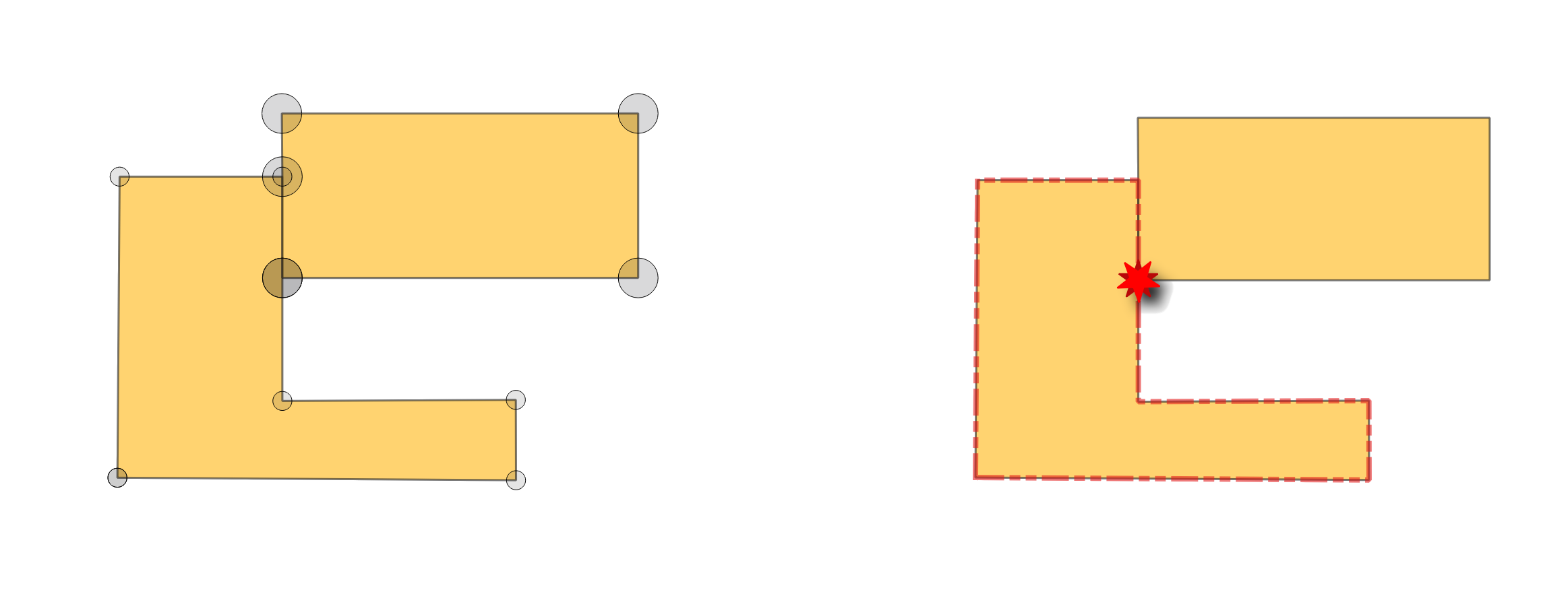
Fig. 24.5 Reporting errors for missing vertices on polygon features.
Vedi anche
Parametri
Parametri di base
Etichetta |
Nome |
Tipo |
Descrizione |
|---|---|---|---|
Layer in ingresso |
|
[vector: polygon] |
Layer with the geometries to check. |
Unique feature identifier |
|
[tablefield: any] |
Field storing unique values for feature identification. |
Missing vertices errors |
|
[vector: point] Predefinito: |
Specification of the output layer containing the errors location. One of:
La codifica del file può anche essere cambiata qui. |
Missing vertices features Opzionale |
|
[vector: polygon] Predefinito: |
Polygon layer with the features whose vertices are missing. One of:
La codifica del file può anche essere cambiata qui. |
Parametri avanzati
Etichetta |
Nome |
Tipo |
Descrizione |
|---|---|---|---|
Tolleranza |
|
[numeric: integer] Predefinito: 8 |
Numerical precision of geometric operations, given as an integer n, meaning that two vertices less than 10-n apart (in map units) are considered to be merged. |
In uscita:
Etichetta |
Nome |
Tipo |
Descrizione |
|---|---|---|---|
Missing vertices errors |
|
[vector: point] |
Output point layer representing the error locations and information. The output layer contains the following fields:
|
Missing vertices features |
|
[vector: polygon] |
Output polygon layer with features whose vertices are missing.
There will be as many (duplicate) features as there are missing vertices in each geometry.
If no vertices are missing, the output layer will be empty.
Available fields are the same as in the |
Codice Python
ID algoritmo: native:checkgeometrymissingvertex
import processing
processing.run("algorithm_id", {parameter_dictionary})
L” id dell’algoritmo viene visualizzato quando si passa il mouse sull’algoritmo nella finestra degli strumenti di elaborazione. Il dizionario dei parametri fornisce i Nomi e i valori dei parametri. Vedi Usare gli algoritmi di Processing dalla console dei comandi per dettagli su come eseguire algoritmi di elaborazione dalla console Python.
24.1.3.10. Overlaps
Aggiunto nella versione 3.42
Calculates overlapping areas in polygon geometries, and reports areas smaller than a given minimum as errors.
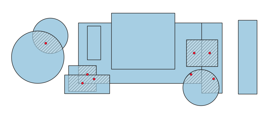
Fig. 24.6 Hashed polygons indicate overlapping areas smaller than the specified minimum.
Vedi anche
Parametri
Parametri di base
Etichetta |
Nome |
Tipo |
Descrizione |
|---|---|---|---|
Layer in ingresso |
|
[vector: polygon] |
Layer with the geometries to check. |
Unique feature identifier |
|
[tablefield: any] |
Field storing unique values for feature identification. |
Minimum overlap area |
|
[numeric: double] |
Minimum area of the overlap to be reported as an error. If set to 0, all overlaps are reported. |
Overlap errors |
|
[vector: point] Predefinito: |
Specification of the output layer containing centroid points of the overlapping areas. One of:
La codifica del file può anche essere cambiata qui. |
Overlap features Opzionale |
|
[vector: polygon] Predefinito: |
Specification of the output layer for features containing overlaps. One of:
La codifica del file può anche essere cambiata qui. |
Parametri avanzati
Etichetta |
Nome |
Tipo |
Descrizione |
|---|---|---|---|
Tolleranza |
|
[numeric: integer] Predefinito: 8 |
Numerical precision of geometric operations, given as an integer n, meaning that two vertices less than 10-n apart (in map units) are considered to be merged. |
In uscita:
Etichetta |
Nome |
Tipo |
Descrizione |
|---|---|---|---|
Overlap errors |
|
[vector: point] |
Output point layer representing the error locations and information. The output layer contains the following fields:
|
Overlap features |
|
[vector: polygon] |
Output layer containing the overlapping areas.
Available fields are the same as in the |
Codice Python
ID algoritmo: native:checkgeometryoverlap
import processing
processing.run("algorithm_id", {parameter_dictionary})
L” id dell’algoritmo viene visualizzato quando si passa il mouse sull’algoritmo nella finestra degli strumenti di elaborazione. Il dizionario dei parametri fornisce i Nomi e i valori dei parametri. Vedi Usare gli algoritmi di Processing dalla console dei comandi per dettagli su come eseguire algoritmi di elaborazione dalla console Python.
24.1.3.11. Points outside lines
Aggiunto nella versione 3.42
Checks if the points in the input layer are covered by a line in the selected line layers. A point not covered by a line is an error.
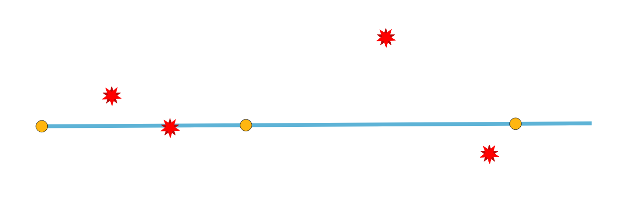
Fig. 24.7 Reporting errors on points not covered by a line.
Parametri
Parametri di base
Etichetta |
Nome |
Tipo |
Descrizione |
|---|---|---|---|
Layer in ingresso |
|
[vector: point] |
Layer with the geometries to check. |
Unique feature identifier |
|
[tablefield: any] |
Field storing unique values for feature identification. |
Layer linea |
|
[vector: line][list] |
Layer(s) with the lines to check against. |
Points not covered by a line |
|
[vector: point] Predefinito: |
Specification of the output layer containing points not covered by a line. One of:
La codifica del file può anche essere cambiata qui. |
Parametri avanzati
Etichetta |
Nome |
Tipo |
Descrizione |
|---|---|---|---|
Tolleranza |
|
[numeric: integer] Predefinito: 8 |
Numerical precision of geometric operations, given as an integer n, meaning that two vertices less than 10-n apart (in map units) are considered to be merged. |
In uscita:
Etichetta |
Nome |
Tipo |
Descrizione |
|---|---|---|---|
Points not covered by a line |
|
[vector: point] |
Output point layer representing the error locations and information. The output layer contains the following fields:
|
Codice Python
ID algoritmo: native:checkgeometrypointcoveredbyline
import processing
processing.run("algorithm_id", {parameter_dictionary})
L” id dell’algoritmo viene visualizzato quando si passa il mouse sull’algoritmo nella finestra degli strumenti di elaborazione. Il dizionario dei parametri fornisce i Nomi e i valori dei parametri. Vedi Usare gli algoritmi di Processing dalla console dei comandi per dettagli su come eseguire algoritmi di elaborazione dalla console Python.
24.1.3.12. Points outside polygons
Aggiunto nella versione 3.42
Checks if points from the input layer are in polygons from the selected polygon layers. Points that are not fully inside polygons are errors.
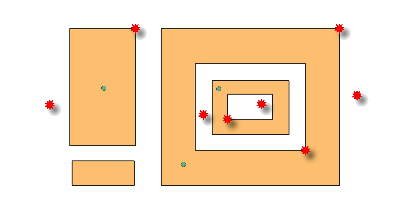
Fig. 24.8 Reporting errors on points outside polygons.
Parametri
Parametri di base
Etichetta |
Nome |
Tipo |
Descrizione |
|---|---|---|---|
Layer in ingresso |
|
[vector: point] |
Layer with the geometries to check. |
Unique feature identifier |
|
[tablefield: any] |
Field storing unique values for feature identification. |
Polygon layers |
|
[vector: polygon][list] |
Layer(s) with the polygons to check against. |
Points outside polygons errors |
|
[vector: point] Predefinito: |
Specification of the output layer containing points outside the polygons. One of:
La codifica del file può anche essere cambiata qui. |
Parametri avanzati
Etichetta |
Nome |
Tipo |
Descrizione |
|---|---|---|---|
Tolleranza |
|
[numeric: integer] Predefinito: 8 |
Numerical precision of geometric operations, given as an integer n, meaning that two vertices less than 10-n apart (in map units) are considered to be merged. |
In uscita:
Etichetta |
Nome |
Tipo |
Descrizione |
|---|---|---|---|
Points outside polygons errors |
|
[vector: point] |
Output point layer representing the error locations and information. The output layer contains the following fields:
|
Codice Python
ID algoritmo: native:checkgeometrypointinpolygon
import processing
processing.run("algorithm_id", {parameter_dictionary})
L” id dell’algoritmo viene visualizzato quando si passa il mouse sull’algoritmo nella finestra degli strumenti di elaborazione. Il dizionario dei parametri fornisce i Nomi e i valori dei parametri. Vedi Usare gli algoritmi di Processing dalla console dei comandi per dettagli su come eseguire algoritmi di elaborazione dalla console Python.
24.1.3.13. Self-contacts
Aggiunto nella versione 3.42
Checks if the geometry has self contact points (in line or polygon), i.e., a vertex that touches more than two segments of the same ring. Self contacts are errors.
Nota
This algorithm detects invalid polygon geometries (self-contacts).
To ensure these invalid features are not filtered out before processing, open
Advanced options next to the Input layer and set
Invalid feature filtering to Do not Filter (Better Performance).
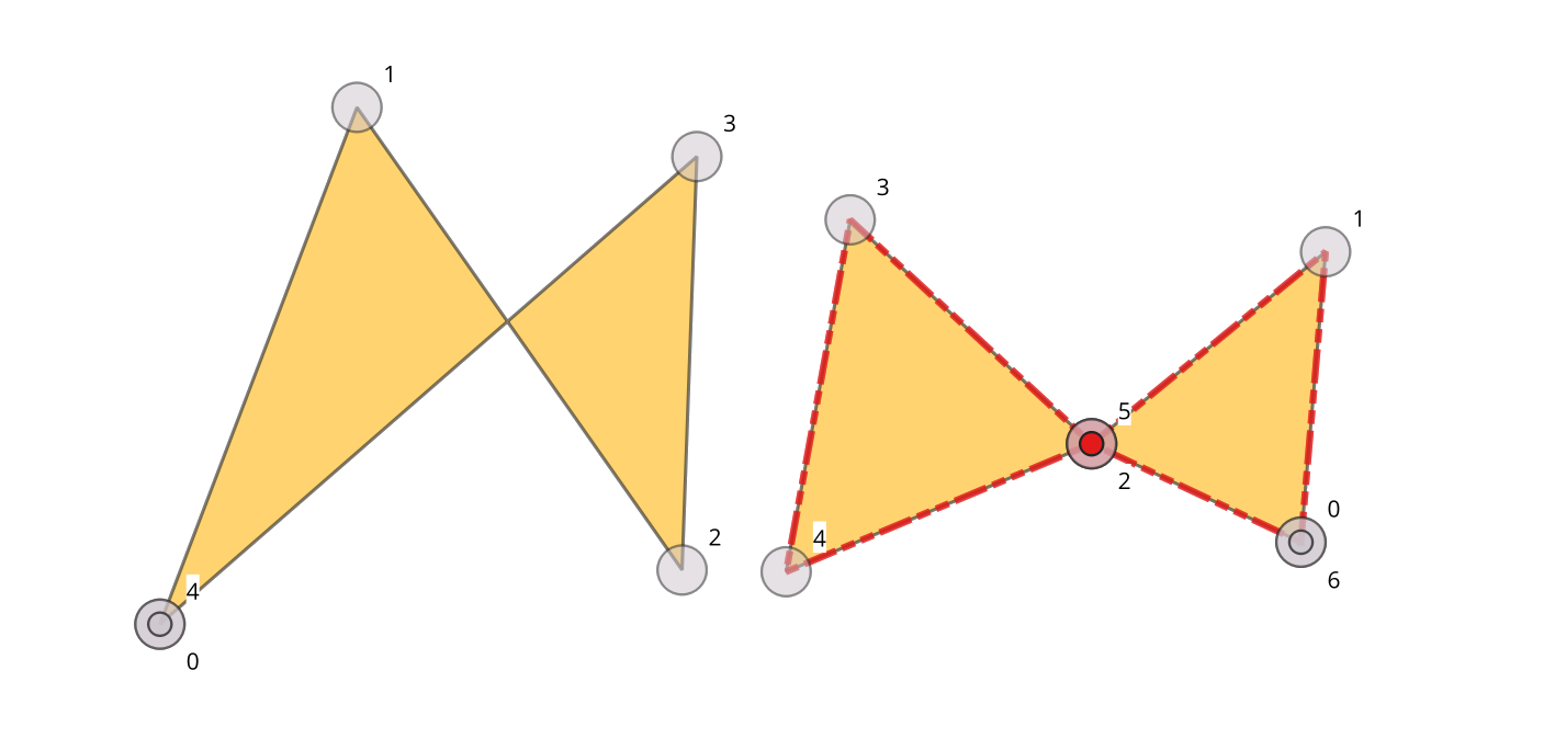
Fig. 24.9 Self-intersection vs self-contact.
Vedi anche
Parametri
Parametri di base
Etichetta |
Nome |
Tipo |
Descrizione |
|---|---|---|---|
Layer in ingresso |
|
[vector: line, polygon] |
Layer with the geometries to check. |
Unique feature identifier |
|
[tablefield: any] |
Field storing unique values for feature identification. |
Self contact error points |
|
[vector: point] Predefinito: |
Specification of the output layer containing the errors location. One of:
La codifica del file può anche essere cambiata qui. |
Self contact features Opzionale |
|
[same as input] Predefinito: |
Line or polygon layer containing self-contact features. One of:
La codifica del file può anche essere cambiata qui. |
Parametri avanzati
Etichetta |
Nome |
Tipo |
Descrizione |
|---|---|---|---|
Tolleranza |
|
[numeric: integer] Predefinito: 8 |
Numerical precision of geometric operations, given as an integer n, meaning that two vertices less than 10-n apart (in map units) are considered to be merged. |
In uscita:
Etichetta |
Nome |
Tipo |
Descrizione |
|---|---|---|---|
Self contact error points |
|
[vector: point] |
Output point layer representing the error locations and information. The output layer contains the following fields:
|
Self contact features |
|
[vector: same as input] |
Output polygon or line layer with features containing the self-contact features.
If no self-contact features are found, the output layer will be empty.
Available fields are the same as in the |
Codice Python
ID algoritmo: native:checkgeometryselfcontact
import processing
processing.run("algorithm_id", {parameter_dictionary})
L” id dell’algoritmo viene visualizzato quando si passa il mouse sull’algoritmo nella finestra degli strumenti di elaborazione. Il dizionario dei parametri fornisce i Nomi e i valori dei parametri. Vedi Usare gli algoritmi di Processing dalla console dei comandi per dettagli su come eseguire algoritmi di elaborazione dalla console Python.
24.1.3.14. Self-intersections
Aggiunto nella versione 3.42
Detects self-intersections in line or polygon geometries, and reports them as errors. Self-intersections occur when the segments of a geometry cross over each other without having a common vertex.
Nota
This algorithm detects invalid polygon geometries (self-intersections).
To ensure these invalid features are not filtered out before processing, open
Advanced options next to the Input layer and set
Invalid feature filtering to Do not Filter (Better Performance).
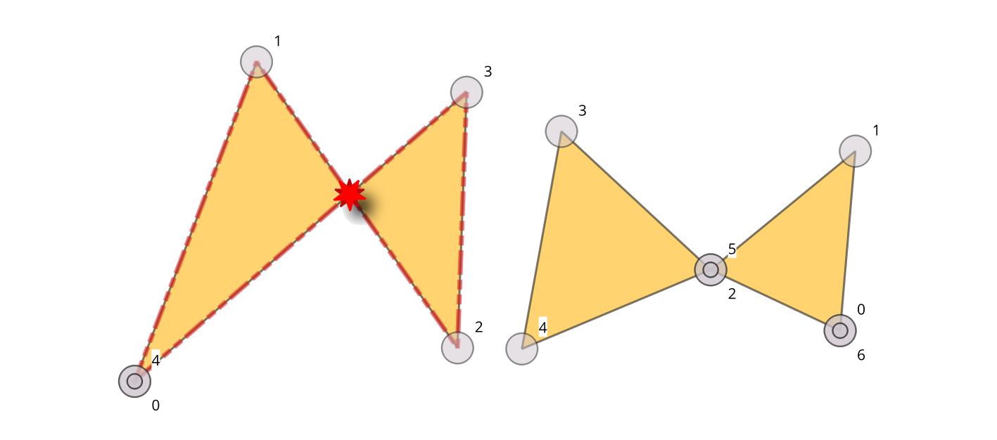
Fig. 24.10 Self-intersection vs self-contact.
Vedi anche
Parametri
Parametri di base
Etichetta |
Nome |
Tipo |
Descrizione |
|---|---|---|---|
Layer in ingresso |
|
[vector: line, polygon] |
Layer with the geometries to check |
Unique feature identifier |
|
[tablefield: any] |
Field storing unique values for feature identification |
Self-intersecting errors |
|
[vector: point] Predefinito: |
Specification of the output layer containing the errors location. One of:
La codifica del file può anche essere cambiata qui. |
Self-intersecting features Opzionale |
|
[same as input] Predefinito: |
Line or polygon layer containing self-intersected features. One of:
La codifica del file può anche essere cambiata qui. |
Parametri avanzati
Etichetta |
Nome |
Tipo |
Descrizione |
|---|---|---|---|
Tolleranza |
|
[numeric: integer] Predefinito: 8 |
Numerical precision of geometric operations, given as an integer n, meaning that two vertices less than 10-n apart (in map units) are considered to be merged. |
In uscita:
Etichetta |
Nome |
Tipo |
Descrizione |
|---|---|---|---|
Self-intersecting errors |
|
[vector: point] |
Output point layer representing the error locations and information. The output layer contains the following fields:
|
Self-intersecting features |
|
[vector: line, polygon] |
Output polygon or line layer with features containing the self-intersecting features.
If no self-intersecting features are found, the output layer will be empty.
Available fields are the same as in the |
Codice Python
ID algoritmo: native:checkgeometryselfintersection
import processing
processing.run("algorithm_id", {parameter_dictionary})
L” id dell’algoritmo viene visualizzato quando si passa il mouse sull’algoritmo nella finestra degli strumenti di elaborazione. Il dizionario dei parametri fornisce i Nomi e i valori dei parametri. Vedi Usare gli algoritmi di Processing dalla console dei comandi per dettagli su come eseguire algoritmi di elaborazione dalla console Python.
24.1.3.15. Sliver polygons
Aggiunto nella versione 3.42
Detects sliver polygons in a polygon layer, i.e., polygons with a thinness greater than a specified value.
The thinness is the ratio between the area of the minimum square containing the polygon and the area of the polygon itself (a square has a thinness value of 1). The thinness value is between 1 and +infinity. A maximum area can be set for limiting the checks to polygons of a lower area. Polygons having a thinness higher than the maximum thinness are errors. To fix sliver polygons, use the Fix small polygons algorithm.
Nota
This algorithm detects invalid polygon geometries (sliver polygons).
To ensure these invalid features are not filtered out before processing, open
Advanced options next to the Input layer and set
Invalid feature filtering to Do not Filter (Better Performance).
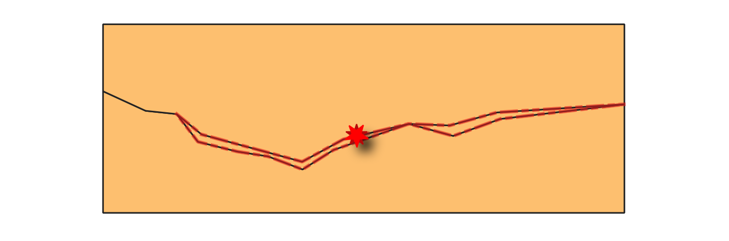
Fig. 24.11 Reporting errors on features with sliver polygons.
Vedi anche
Parametri
Parametri di base
Etichetta |
Nome |
Tipo |
Descrizione |
|---|---|---|---|
Layer in ingresso |
|
[vector: polygon] |
Layer with the geometries to check. |
Unique feature identifier |
|
[tablefield: any] |
Field storing unique values for feature identification. |
Maximum thinness |
|
[numeric: double] Default: 20.0 |
Maximum thinness value of a polygon to be considered valid. Any polygon with a thinness value above this threshold is reported as error. |
Maximum area (map units squared) |
|
[numeric: double] Predefinito: 0.0 |
Maximum area of a polygon to be checked (in map units). Any polygon with an area above this threshold is skipped. A value of 0 means all polygons are checked. |
Sliver polygon errors |
|
[vector: point] Predefinito: |
Specification of the output layer containing the centroid points of sliver polygon features. One of:
La codifica del file può anche essere cambiata qui. |
Sliver polygon features Opzionale |
|
[vector: polygon] Predefinito: |
Polygon layer containing sliver polygon features. One of:
La codifica del file può anche essere cambiata qui. |
Parametri avanzati
Etichetta |
Nome |
Tipo |
Descrizione |
|---|---|---|---|
Tolleranza |
|
[numeric: integer] Predefinito: 8 |
Numerical precision of geometric operations, given as an integer n, meaning that two vertices less than 10-n apart (in map units) are considered to be merged. |
In uscita:
Etichetta |
Nome |
Tipo |
Descrizione |
|---|---|---|---|
Sliver polygon errors |
|
[vector: point] |
Output point layer representing the error locations and information. The output layer contains the following fields:
|
Sliver polygon features |
|
[vector: polygon] |
Output layer with features containing the sliver polygons.
If no sliver polygon features are found, the output layer will be empty.
Available fields are the same as in the |
Codice Python
ID algoritmo: native:checkgeometrysliverpolygon
import processing
processing.run("algorithm_id", {parameter_dictionary})
L” id dell’algoritmo viene visualizzato quando si passa il mouse sull’algoritmo nella finestra degli strumenti di elaborazione. Il dizionario dei parametri fornisce i Nomi e i valori dei parametri. Vedi Usare gli algoritmi di Processing dalla console dei comandi per dettagli su come eseguire algoritmi di elaborazione dalla console Python.
24.1.3.16. Angoli piccoli
Aggiunto nella versione 3.42
Compares the angles within line or polygon geometries to a specified threshold, and reports as error any angle below that value.
Fig. 24.12 Reporting errors on a line feature for angles lower than 15°.
Vedi anche
Parametri
Parametri di base
Etichetta |
Nome |
Tipo |
Descrizione |
|---|---|---|---|
Layer in ingresso |
|
[vector: line, polygon] |
Layer with the geometries to check. |
Unique feature identifier |
|
[tablefield: any] |
Field storing unique values for feature identification. |
Angolo minimo |
|
[numeric: double] |
Allowed minimum angle between adjacent segments in a feature’s geometry. Any angle below this threshold is reported as error. |
Small angle errors |
|
[vector: point] Predefinito: |
Specification of the output layer containing the errors location. One of:
La codifica del file può anche essere cambiata qui. |
Parametri avanzati
Etichetta |
Nome |
Tipo |
Descrizione |
|---|---|---|---|
Tolleranza |
|
[numeric: integer] Predefinito: 8 |
Numerical precision of geometric operations, given as an integer n, meaning that two vertices less than 10-n apart (in map units) are considered to be merged. |
In uscita:
Etichetta |
Nome |
Tipo |
Descrizione |
|---|---|---|---|
Small angle errors |
|
[vector: point] |
Output point layer representing the error locations and information. The output layer contains the following fields:
|
Codice Python
ID algoritmo: native:checkgeometryangle
import processing
processing.run("algorithm_id", {parameter_dictionary})
L” id dell’algoritmo viene visualizzato quando si passa il mouse sull’algoritmo nella finestra degli strumenti di elaborazione. Il dizionario dei parametri fornisce i Nomi e i valori dei parametri. Vedi Usare gli algoritmi di Processing dalla console dei comandi per dettagli su come eseguire algoritmi di elaborazione dalla console Python.
24.1.3.17. Small polygons
Aggiunto nella versione 3.42
Detects polygon features whose area is below a specified value as errors.
Nota
This algorithm detects invalid polygon geometries (small polygons).
To ensure these invalid features are not filtered out before processing, open
Advanced options next to the Input layer and set
Invalid feature filtering to Do not Filter (Better Performance).
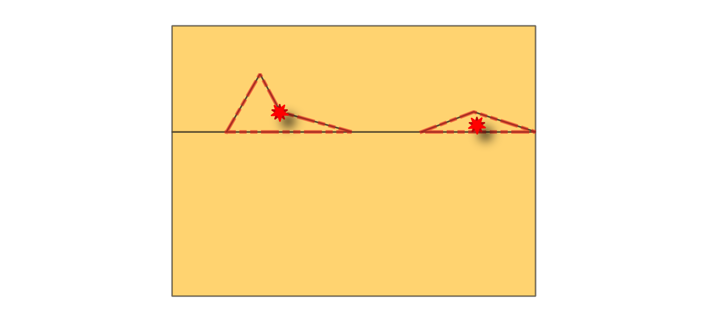
Fig. 24.13 Reporting errors on features with small polygons (below given area threshold).
Vedi anche
Parametri
Parametri di base
Etichetta |
Nome |
Tipo |
Descrizione |
|---|---|---|---|
Layer in ingresso |
|
[vector: polygon] |
Layer with the geometries to check. |
Unique feature identifier |
|
[tablefield: any] |
Field storing unique values for feature identification. |
Area threshold |
|
[numeric: double] Valore predefinito: 0 |
Minimum area of a polygon to be considered valid, in selected units. Any polygon with an area below this threshold is reported as error. |
Small polygons errors |
|
[vector: point] Predefinito: |
Specification of the output layer containing centroid points of small polygons. One of:
La codifica del file può anche essere cambiata qui. |
Small polygons features Opzionale |
|
[vector: polygon] Predefinito: |
Specification of the output layer for features containing small polygon features. One of:
La codifica del file può anche essere cambiata qui. |
Parametri avanzati
Etichetta |
Nome |
Tipo |
Descrizione |
|---|---|---|---|
Tolleranza |
|
[numeric: integer] Predefinito: 8 |
Numerical precision of geometric operations, given as an integer n, meaning that two vertices less than 10-n apart (in map units) are considered to be merged. |
In uscita:
Etichetta |
Nome |
Tipo |
Descrizione |
|---|---|---|---|
Small polygons errors |
|
[vector: point] |
Output point layer representing the error locations and information. The output layer contains the following fields:
|
Small polygons features |
|
[vector: polygon] |
Output polygon layer with features containing the small polygon features.
If no small polygon features are found, the output layer will be empty.
Available fields are the same as in the |
Codice Python
ID algoritmo: native:checkgeometryarea
import processing
processing.run("algorithm_id", {parameter_dictionary})
L” id dell’algoritmo viene visualizzato quando si passa il mouse sull’algoritmo nella finestra degli strumenti di elaborazione. Il dizionario dei parametri fornisce i Nomi e i valori dei parametri. Vedi Usare gli algoritmi di Processing dalla console dei comandi per dettagli su come eseguire algoritmi di elaborazione dalla console Python.
24.1.3.18. Small gaps
Aggiunto nella versione 3.42
Checks for gaps between polygons in the input layer. Gaps with an area smaller than the gap threshold are reported as errors. If an allowed gaps layer is provided, the algorithm ignores gaps that fall entirely within polygons from this layer. An optional buffer can be applied to the allowed gaps.
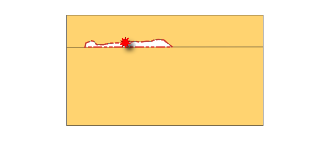
Fig. 24.14 Reporting errors on polygon features for gaps smaller than the specified threshold.
Vedi anche
Parametri
Parametri di base
Etichetta |
Nome |
Tipo |
Descrizione |
|---|---|---|---|
Layer in ingresso |
|
[vector: polygon] |
Layer with the geometries to check. |
Unique feature identifier |
|
[tablefield: any] |
Field storing unique values for feature identification. |
Gap threshold |
|
[numeric: double] Predefinito: 0.0 |
Maximum area of gaps to be reported as errors, in map units. If set to 0, all the gaps are reported. |
Allowed gaps layer Opzionale |
|
[vector: polygon] |
Optional layer specifying polygons whose areas should be ignored during the gap check. Gaps that fall entirely within these polygons will not be reported as errors. |
Allowed gaps buffer Opzionale |
|
[numeric: double] Predefinito: 0.0 |
Buffer distance to apply to the allowed gaps layer, in selected units. Gaps located within this buffered area are ignored. Allows adding a spatial tolerance around allowed gaps to avoid reporting near-boundary gaps as errors. |
Layer confinanti |
|
[vector: table] Predefinito: |
Specification of the output table representing the gap ID and the unique ID of its neighbor features. One of:
La codifica del file può anche essere cambiata qui. |
Gap errors Opzionale |
|
[vector: point] Predefinito: |
Specification of the output layer containing the centroid points of the gaps. One of:
La codifica del file può anche essere cambiata qui. |
Gap features |
|
[vector: polygon] Predefinito: |
Specification of the output layer containing the gap geometries. One of:
La codifica del file può anche essere cambiata qui. |
Parametri avanzati
Etichetta |
Nome |
Tipo |
Descrizione |
|---|---|---|---|
Tolleranza |
|
[numeric: integer] Predefinito: 8 |
Numerical precision of geometric operations, given as an integer n, meaning that two vertices less than 10-n apart (in map units) are considered to be merged. |
In uscita:
Etichetta |
Nome |
Tipo |
Descrizione |
|---|---|---|---|
Layer confinanti |
|
[vector: table] |
A 1–N relational table, meaning that one gap can be associated with multiple neighboring polygons. The output table contains the following fields:
|
Gap errors |
|
[vector: point] |
Output point layer representing the error locations and information. The output layer contains the following fields:
|
Gap features |
|
[vector: polygon] |
Output layer containing the gap geometries.
Available fields are the same as in the |
Codice Python
Algorithm ID: native:checkgeometrygap
import processing
processing.run("algorithm_id", {parameter_dictionary})
L” id dell’algoritmo viene visualizzato quando si passa il mouse sull’algoritmo nella finestra degli strumenti di elaborazione. Il dizionario dei parametri fornisce i Nomi e i valori dei parametri. Vedi Usare gli algoritmi di Processing dalla console dei comandi per dettagli su come eseguire algoritmi di elaborazione dalla console Python.
24.1.3.19. Small segments
Aggiunto nella versione 3.42
Calculates length of individual segments in line or polygon geometries, and reports segments shorter than a minimum length as errors.
Fig. 24.15 Reporting errors (in red) on single line segments shorter than the given threshold.
Vedi anche
Parametri
Parametri di base
Etichetta |
Nome |
Tipo |
Descrizione |
|---|---|---|---|
Layer in ingresso |
|
[vector: line, polygon] |
Layer with the geometries to check. |
Unique feature identifier |
|
[tablefield: any] |
Field storing unique values for feature identification. |
Minimum segment length |
|
[numeric: double] Predefinito: 0.0 |
Minimum length of segments to be considered valid, in map units. |
Short segments errors |
|
[vector: point] Predefinito: |
Specification of the output layer containing centroid of short segments. One of:
La codifica del file può anche essere cambiata qui. |
Short segments features Opzionale |
|
[vector: same as input] Predefinito: |
Specification of the output layer for features containing short segments. One of:
La codifica del file può anche essere cambiata qui. |
Parametri avanzati
Etichetta |
Nome |
Tipo |
Descrizione |
|---|---|---|---|
Tolleranza |
|
[numeric: integer] Predefinito: 8 |
Numerical precision of geometric operations, given as an integer n, meaning that two vertices less than 10-n apart (in map units) are considered to be merged. |
In uscita:
Etichetta |
Nome |
Tipo |
Descrizione |
|---|---|---|---|
Short segments errors |
|
[vector: point] |
Output point layer representing the error locations and information. The output layer contains the following fields:
|
Short segments features |
|
[vector: same as input] |
Output layer containing, for each identified short segment, the feature it belongs to.
Available fields are the same as in the |
Codice Python
ID algoritmo: native:checkgeometrysegmentlength
import processing
processing.run("algorithm_id", {parameter_dictionary})
L” id dell’algoritmo viene visualizzato quando si passa il mouse sull’algoritmo nella finestra degli strumenti di elaborazione. Il dizionario dei parametri fornisce i Nomi e i valori dei parametri. Vedi Usare gli algoritmi di Processing dalla console dei comandi per dettagli su come eseguire algoritmi di elaborazione dalla console Python.
24.1.3.20. Strictly multipart
Aggiunto nella versione 3.42
Checks if multipart geometries have more than one part. Multipart geometries with only one part are errors.
Vedi anche
Parametri
Parametri di base
Etichetta |
Nome |
Tipo |
Descrizione |
|---|---|---|---|
Layer in ingresso |
|
[vector: geometry] |
Layer with the geometries to check. |
Unique feature identifier |
|
[tablefield: any] |
Field storing unique values for feature identification. |
One-part geometry errors |
|
[vector: point] Predefinito: |
Specification of the output layer containing centroid of the multipart geometries that have only one part. One of:
La codifica del file può anche essere cambiata qui. |
One-part geometry features Opzionale |
|
[vector: same as input] Predefinito: |
Specification of the output layer for features containing multipart geometries that have only one part. One of:
La codifica del file può anche essere cambiata qui. |
Parametri avanzati
Etichetta |
Nome |
Tipo |
Descrizione |
|---|---|---|---|
Tolleranza |
|
[numeric: integer] Predefinito: 8 |
Numerical precision of geometric operations, given as an integer n, meaning that two vertices less than 10-n apart (in map units) are considered to be merged. |
In uscita:
Etichetta |
Nome |
Tipo |
Descrizione |
|---|---|---|---|
One-part geometry errors |
|
[vector: point] |
Output point layer representing the error locations and information. The output layer contains the following fields:
|
One-part geometry features |
|
[vector: same as input] |
Output layer containing features that are multipart but have only one part.
Available fields are the same as in the |
Codice Python
ID algoritmo: native:checkgeometrymultipart
import processing
processing.run("algorithm_id", {parameter_dictionary})
L” id dell’algoritmo viene visualizzato quando si passa il mouse sull’algoritmo nella finestra degli strumenti di elaborazione. Il dizionario dei parametri fornisce i Nomi e i valori dei parametri. Vedi Usare gli algoritmi di Processing dalla console dei comandi per dettagli su come eseguire algoritmi di elaborazione dalla console Python.