QGIS Configuration
QGIS is highly configurable. Through the menu, it provides different tools to:
 Options…: set global options to
apply in different areas of the software. These preferences are saved in the
active User profile settings and applied by default
whenever you open a new project with this profile.
Also, they can be overridden during each QGIS session by the project
properties (accessible under menu).
Options…: set global options to
apply in different areas of the software. These preferences are saved in the
active User profile settings and applied by default
whenever you open a new project with this profile.
Also, they can be overridden during each QGIS session by the project
properties (accessible under menu). Interface Customization…: configure the
application interface, hiding dialogs or tools you may
not need.
Interface Customization…: configure the
application interface, hiding dialogs or tools you may
not need. Keyboard Shortcuts…: define your own set of
keyboard shortcuts.
Keyboard Shortcuts…: define your own set of
keyboard shortcuts. Style Manager…: create and manage symbols and
color ramps.
Style Manager…: create and manage symbols and
color ramps. Custom Projections…: create your own
coordinate reference systems.
Custom Projections…: create your own
coordinate reference systems.
Options
Some basic options for QGIS can be selected using the
Options dialog. Select the menu option
.
You can modify the options according to your needs. Some of the changes may
require a restart of QGIS before they will be effective.
The tabs where you can customize your options are described below.
Note
Plugins can embed their settings within the Options dialog
While only Core settings are presented below, note that this list can be extended by installed plugins implementing their own options into the standard Options dialog. This avoids each plugin having their own config dialog with extra menu items just for them…
General Settings
Locale Settings
Check
 Override system locale if you want to use a language
different from your system’s and pick the replacement in Locale to use
instead combobox.
Override system locale if you want to use a language
different from your system’s and pick the replacement in Locale to use
instead combobox.Information about active system locale are provided.
Application
Select the Style (QGIS restart required)
 and choose
between ‘Oxygen’, ‘Windows’, ‘Motif’, ‘CDE’, ‘Plastique’ and ‘Cleanlooks’;
and choose
between ‘Oxygen’, ‘Windows’, ‘Motif’, ‘CDE’, ‘Plastique’ and ‘Cleanlooks’;Define the UI theme
. It can be ‘default’ or ‘Night Mapping’;Define the Icon size
;Define the Font and its Size. The font can be
 Qt default or a user-defined one;
Change the Timeout for timed messages or dialogs
;- Hide splash screen at startup;
- Check QGIS version at startup to keep you informed
if a newer version is released;
- Modeless data source manager dialog to keep the
data source manager dialog opened and allow
interaction with QGIS interface while adding layers to project;
- Use native color chooser dialogs (see Color Selector).
Project files
Open project on launch
(choose between ‘New’,
‘Most recent’, ‘Welcome Page’, and ‘Specific’). When choosing ‘Specific’ use
the … button to define the project to use by default. The ‘Welcome Page’
displays a list of recent projects with screenshot.- Create new project from default project. You have the
possibility to press on Set current project as default or on
Reset default. You can browse through your files and define a
directory where you find your user-defined project templates. This will be
added to . If you first activate
Create new project from default project and then save
a project in the project templates folder.
- Prompt to save project and data source changes when
required to avoid losing changes you made.
- Prompt for confirmation when a layer is to be removed
- Warn when opening a project file saved with an older
version of QGIS. You can always open projects created with older version of
QGIS but once the project is saved, trying to open with older release may fail
because of features not available in that version.
Enable macros
. This option was created to handle
macros that are written to perform an action on project events. You can
choose between ‘Never’, ‘Ask’, ‘For this session only’ and
‘Always (not recommended)’.
System Settings
SVG paths
Add or Remove Path(s) to search for Scalable Vector Graphic (SVG) symbols. These SVG files are then available to symbolize features or decorate your map composition.
Plugin paths
Add or Remove Path(s) to search for additional C++ plugin libraries.
Documentation paths
Add or Remove Documentation Path(s) to use for QGIS help. By default, a link to the official online User Manual corresponding to the version being used is added. You can however add other links and prioritize them from top to bottom: each time you click on a Help button in a dialog, the topmost link is checked and if no corresponding page is found, the next one is tried, and so on.
Note
Documentation is versioned and translated only for QGIS Long Term Releases (LTR), meaning that if you are running a regular release (eg, QGIS 3.0), the help button will by default open the next LTR manual page (ie. 3.4 LTR), which may contain description of features in newer releases (3.2 and 3.4). If no LTR documentation is available then the testing doc, with features from newer and development versions, is used.
QSettings
It helps you Reset user interface to default settings (restart required) if you made any customization.
Environment
System environment variables can now be viewed, and many configured, in the Environment group (see figure_environment_variables). This is useful for platforms, such as Mac, where a GUI application does not necessarily inherit the user’s shell environment. It’s also useful for setting and viewing environment variables for the external tool sets controlled by the Processing toolbox (e.g., SAGA, GRASS), and for turning on debugging output for specific sections of the source code.
- Use custom variables (restart required - include separators).
You can Add and Remove variables. Already-defined environment
variables are displayed in Current environment variables, and it’s
possible to filter them by activating
Show only QGIS-specific variables.
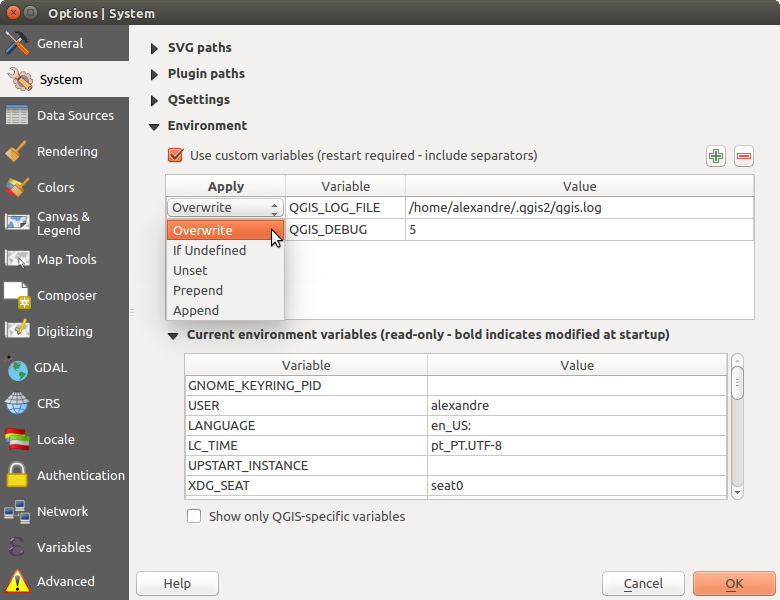
System environment variables in QGIS
CRS Settings
Default CRS for new projects
There is an option to automatically set new project’s CRS:
- Use CRS from first layer added: the CRS of the project
is turned to match the CRS of the first layer loaded into it
 Use a default CRS: a preselected CRS is applied by
default to any new project and is left unchanged when adding layers to the
project.
Use a default CRS: a preselected CRS is applied by
default to any new project and is left unchanged when adding layers to the
project.
The choice will be saved for use in subsequent QGIS sessions and in any case, the Coordinate Reference System of the project can still be overridden from the tab.
CRS for new layers
This area allows you to define the action to take when a new layer is created, or when a layer without a CRS is loaded.
- Prompt for CRS
- Use project CRS
- Use a default CRS
Default datum transformations
In this group, you can control whether reprojecting layers to another CRS should be:
automatically processed using QGIS default transformations settings;
and/or more controlled by you with custom preferences such as:
- Ask for datum transformation if several are available
a predefined list of datum transformations to apply by default. See Datum Transformations for more details.
Note
For more information on how QGIS handles layers projection, please read the dedicated section at Working with Projections.
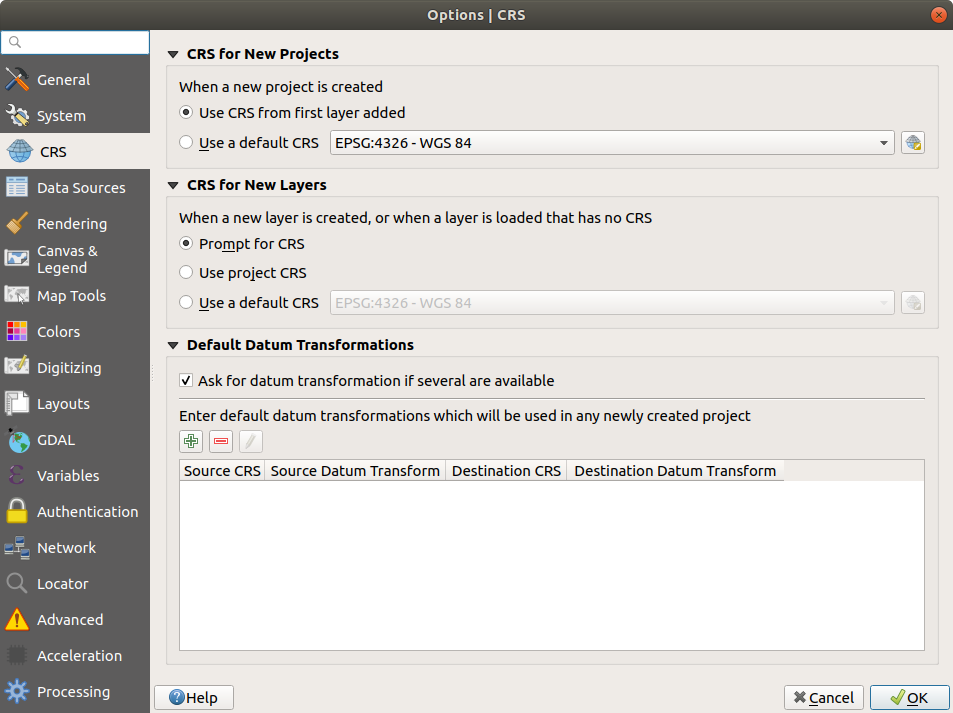
CRS Settings in QGIS
Data Sources Settings
Feature attributes and table
- Open attribute table in a dock window
Copy features as ‘Plain text, no geometry’, ‘Plain text, WKT geometry’, or ‘GeoJSON’ when pasting features in other applications.
Attribute table behavior
: set filter on the attribute
table at the opening. There are three possibilities: ‘Show all features’,
‘Show selected features’ and ‘Show features visible on map’.Default view: define the view mode of the attribute table at every opening. It can be ‘Remember last view’, ‘Table view’ or ‘Form view’.
Attribute table row cache
 . This row cache makes
it possible to save the last loaded N attribute rows so that working with the
attribute table will be quicker. The cache will be deleted when closing the
attribute table.
. This row cache makes
it possible to save the last loaded N attribute rows so that working with the
attribute table will be quicker. The cache will be deleted when closing the
attribute table.Representation for NULL values. Here, you can define a value for data fields containing a NULL value.
Tip
Improve opening of big data attribute table
When working with layers with big amount of records, opening the attribute table may be slow as the dialog request all the rows in the layer. Setting the Attribute table behavior to Show features visible on map will make QGIS request only the features in the current map canvas when opening the table, allowing a quick data loading.
Note that data in this attribute table instance will be always tied to the canvas extent it was opened with, meaning that selecting Show All Features within such a table will not display new features. You can however update the set of displayed features by changing the canvas extent and selecting Show Features Visible On Map option in the attribute table.
Data source handling
Scan for valid items in the browser dock
. You can
choose between ‘Check extension’ and ‘Check file contents’.Scan for contents of compressed files (.zip) in browser dock
defines how detailed is the widget information at the bottom
of the Browser panel when querying such files. ‘No’, ‘Basic scan’ and ‘Full scan’
are possible options.Prompt for raster sublayers when opening. Some rasters support sublayers — they are called subdatasets in GDAL. An example is netCDF files — if there are many netCDF variables, GDAL sees every variable as a subdataset. The option allows you to control how to deal with sublayers when a file with sublayers is opened. You have the following choices:
‘Always’: Always ask (if there are existing sublayers)
‘If needed’: Ask if layer has no bands, but has sublayers
‘Never’: Never prompt, will not load anything
‘Load all’: Never prompt, but load all sublayers
- Ignore shapefile encoding declaration. If a shapefile
has encoding information, this will be ignored by QGIS.
- Add PostGIS layers with double click and select in
extended mode
- Add Oracle layers with double click and select in
extended mode
- Execute expressions on server-side if possible
- Evaluate default values defines whether default values
from database provider should be calculated when digitizing the new feature
(checked status) or when saving the changes.
Hidden Browser Path
This widget lists all the folders you chose to hide from the Browser panel. Removing a folder from the list will make it available in the Browser panel.
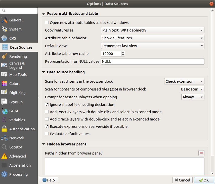
Data Sources Settings in QGIS
Rendering Settings
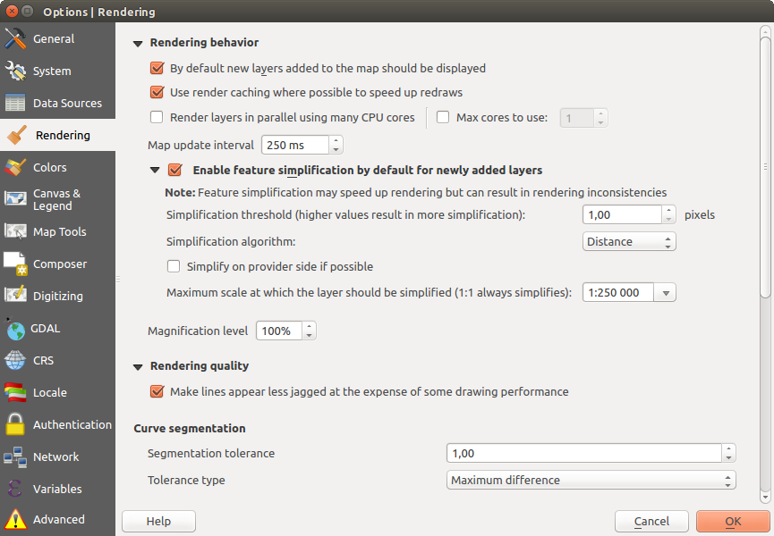
Rendering tab of Project Properties dialog
Rendering behavior
 By default new layers added to the map should be
displayed: unchecking this option can be handy when loading multiple layers
to avoid each new layer being rendered in the canvas and slow down the process
By default new layers added to the map should be
displayed: unchecking this option can be handy when loading multiple layers
to avoid each new layer being rendered in the canvas and slow down the process- Use render caching where possible to speed up redraws
- Render layers in parallel using many CPU cores
- Max cores to use
Map update interval (default to 250 ms)
- Enable feature simplification by default for newly added layers
Simplification threshold
Simplification algorithm: This option performs a local “on-the-fly” simplification on feature’s and speeds up geometry rendering. It doesn’t change the geometry fetched from the data providers. This is important when you have expressions that use the feature geometry (e.g. calculation of area) - it ensures that these calculations are done on the original geometry, not on the simplified one. For this purpose, QGIS provides three algorithms: ‘Distance’ (default), ‘SnapToGrid’ and ‘Visvalingam’.
- Simplify on provider side if possible: the geometries
are simplified by the provider (PostGIS, Oracle…) and unlike the
local-side simplification, geometry-based calculations may be affected
Maximum scale at which the layer should be simplified
 Magnification level (see the magnifier)
Note
Besides the global setting, feature simplification can be set for any specific layer from its menu.
Rendering quality
- Make lines appear less jagged at the expense of some
drawing performance
Curve segmentation
Segmentation tolerance: this setting controls the way circular arcs are rendered. The smaller maximum angle (between the two consecutive vertices and the curve center, in degrees) or maximum difference (distance between the segment of the two vertices and the curve line, in map units), the more straight line segments will be used during rendering.
Tolerance type: it can be Maximum angle or Maximum difference between approximation and curve.
Rasters
With RGB band selection, you can define the number for the Red, Green and Blue band.
Contrast enhancement
Contrast enhancement options can be applied to Single band gray, Multi band color (byte/band) or Multi band color (>byte/band). For each, you can set:
the Algorithm to use, whose values can be ‘No stretch’, ‘Stretch to MinMax’, ‘Stretch and Clip to MinMax’ or ‘Clip to MinMax’
the Limits (minimum/maximum) to apply, with values such as ‘Cumulative pixel count cut’, ‘Minimum/Maximum’, ‘Mean +/- standard deviation’.
For rasters rendering, you can also define the following options:
Cumulative pixel count cut limits
Standard deviation multiplier
Debugging
- Map canvas refresh to debug rendering duration in
the Log Messages panel.
Canvas and Legend Settings
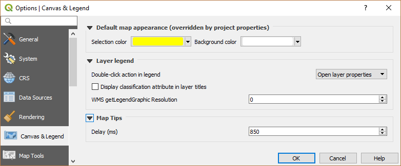
Canvas and Legend Settings
These properties let you set:
the Default map appearance (overridden by project properties): the Selection color and Background color.
Layer legend interaction:
Double click action in legend
. You can either
‘Open layer properties’, ‘Open attribute table’ or ‘Open layer styling dock’
with the double click.- Display classification attribute names in the Layers
panel, e.g. when applying a categorized or rule-based renderer
(see Symbology Properties for more information).
the WMS getLegendGraphic Resolution
the Delay in milliseconds of layers map tips display
Map tools Settings
This tab offers some options regarding the behavior of the Identify tool.
Search radius for identifying features and displaying map tips is a tolerance distance within which the identify tool will depict results as long as you click within this tolerance.
Highlight color allows you to choose with which color should features being identified be highlighted.
Buffer determines a buffer distance to be rendered from the outline of the identify highlight.
Minimum width determines how thick should the outline of a highlighted object be.
Measure tool
Define Rubberband color for measure tools
Define Decimal places
- Keep base unit to not automatically convert large numbers
(e.g., meters to kilometers)
Preferred distance units
(‘Meters’, ‘Kilometers’, ‘Feet’,
‘Yards’, ‘Miles’, ‘Nautical Miles’, ‘Degrees’ or ‘Map Units’ )Preferred area units
(‘Square meters’, ‘Square
kilometers’, ‘Square feet’, ‘Square yards’, ‘Square miles’, ‘Hectares’,
‘Acres’, ‘Square nautical miles’, ‘Square degrees’ or ‘Map Units’)Preferred angle units
(‘Degrees’, ‘Radians’, ‘Gon/gradians’,
‘Minutes of arc’, ‘Seconds of arc’ or ‘Turns/revolutions’)
Panning and zooming
Define a Zoom factor for zoom tools or wheel mouse
Predefined scales
Here, you find a list of predefined scales. With the  and
and  buttons you can add or remove your personal scales.
You can also import or export scales from/to a
buttons you can add or remove your personal scales.
You can also import or export scales from/to a .XML file. Note that you still have
the possibility to remove your changes and reset to the predefined list.
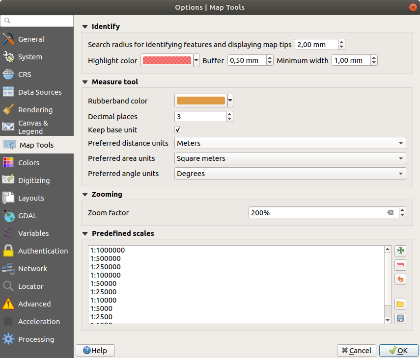
Map tools Settings in QGIS
Colors Settings
This menu allows you to create or update palettes of colors used throughout the application in the color selector widget. You can choose from:
Recent colors showing recently used colors
Standard colors, the default palette of colors
Project colors, a set of colors specific to the current project (see Default Styles Properties for more details)
New layer colors, a set of colors to use by default when new layers are added to QGIS
or custom palette(s) you can create or import using the … button next to the palette combobox.
By default, Recent colors, Standard colors and Project colors palettes can not be removed and are set to appear in the color button drop-down. Custom palettes can also be added to this widget thanks to the Show in Color Buttons option.
For any of the palettes, you can manage the list of colors using the set of tools next to the frame, ie:
- Add or Remove color
 Copy or
  Paste color
 Import or
  Export the set of colors
from/to
Export the set of colors
from/to .gplfile.
Double-click a color in the list to tweak or replace it in the Color Selector dialog. You can also rename it by double-clicking in the Label column.
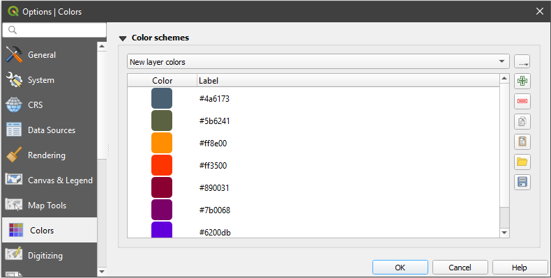
Colors Settings
Digitizing Settings
This tab helps you configure general settings when editing vector layer (attributes and geometry).
Feature creation
- Suppress attribute form pop-up after feature creation:
this choice can be overridden in each layer properties dialog.
- Reuse last entered attribute values.
Validate geometries. Editing complex lines and polygons with many nodes can result in very slow rendering. This is because the default validation procedures in QGIS can take a lot of time. To speed up rendering, it is possible to select GEOS geometry validation (starting from GEOS 3.3) or to switch it off. GEOS geometry validation is much faster, but the disadvantage is that only the first geometry problem will be reported.
Default Z value to use when creating new 3D features.
Rubberband
Define Rubberband Line width, Line color and Fill color.
Don’t update rubberband during vertex editing.
Snapping
- Enable snapping by default activates snapping when
a project is opened
Define Default snap mode
(‘Vertex’, ‘Vertex and segment’,
‘Segment’)Define Default snapping tolerance in map units or pixels
Define the Search radius for vertex edits in map units or pixels
Display main dialog as (restart required): set whether the Advanced Snapping dialog should be shown as ‘Dialog’ or ‘Dock’.
Snapping marker color
- Show snapping tooltips such as name of the layer whose
feature you are about to snap. Helpful when multiple features overlap.
- Enable snapping on invisible features
Vertex markers
- Show markers only for selected features
Define vertex Marker style
(‘Cross’ (default), ‘Semi
transparent circle’ or ‘None’)Define vertex Marker size
Curve offset tool
The next 3 options refer to the  Offset Curve tool in
Advanced digitizing. Through the various settings, it is possible to
influence the shape of the line offset. These options are possible starting
from GEOS 3.3.
Offset Curve tool in
Advanced digitizing. Through the various settings, it is possible to
influence the shape of the line offset. These options are possible starting
from GEOS 3.3.
Join style: ‘Round’, ‘Mitre’ or ‘Bevel’
Quadrant segments
Miter limit
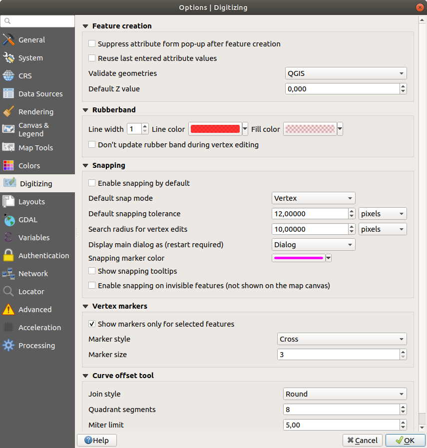
Digitizing Settings in QGIS
Layouts Settings
Composition defaults
You can define the Default font used within the print layout.
Grid appearance
Define the Grid style
(‘Solid’, ‘Dots’, ‘Crosses’)Define the Grid color
Grid and guide defaults
Define the Grid spacing
Define the Grid offset
for X and YDefine the Snap tolerance
Layout Paths
Define Path(s) to search for extra print templates: a list of folders with custom layout templates to use while creating new one.
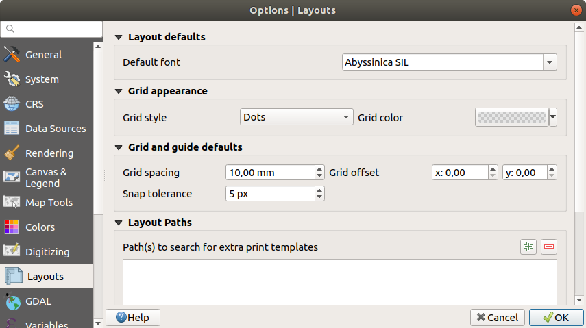
Layouts Settings in QGIS
GDAL Settings
GDAL is a data exchange library for vector and raster files. It provides drivers to read and or write data in different formats. The GDAL tab currently exposes the drivers for raster formats with their capabilities.
GDAL driver options
This frame provides ways to customize the behavior of drivers that support read and write access:
Edit create options: allows you to edit or add different profiles of file transformation, i.e. a set of predefined combinations of parameters (type and level of compression, blocks size, overview, colorimetry, alpha…) to use when outputting raster files. The parameters depend on the driver.
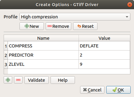
Sample of create options profile (for GeoTiff)
The upper part of the dialog lists the current profile(s) and allows you to add new ones or remove any of them. You can also reset the profile to its default parameters if you have changed them. Some drivers (eg, GeoTiff) have some sample of profiles you can work with.
At the bottom of the dialog:
The
button lets you add rows to fill with the parameter name and valueThe
button deletes the selected parameterClick the Validate button to check that the creation options entered for the given format are valid
Use the Help button to find the parameters to use, or refer to the GDAL raster drivers documentation.
Edit Pyramids Options
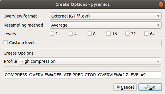
Sample of Pyramids profile
GDAL drivers
In this frame, you can define which GDAL driver is to use to read and/or write files, as in some cases more than one GDAL driver is available.
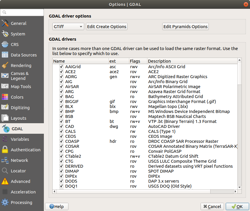
GDAL Settings in QGIS
Tip
Double-click a driver that allows read and write access (rw+(v))
opens the Edit Create options dialog for
customization.
Variables Settings
The Variables tab lists all the variables available at the global-level.
It also allows the user to manage global-level variables. Click the
button to add a new custom global-level variable. Likewise, select a custom
global-level variable from the list and click the button to remove
it.
More information about variables in the Storing values in Variables section.
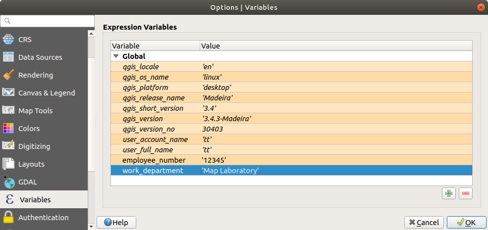
Variables Settings in QGIS
Authentication Settings
In the Authentication tab you can set authentication configurations and manage PKI certificates. See Authentication System for more details.
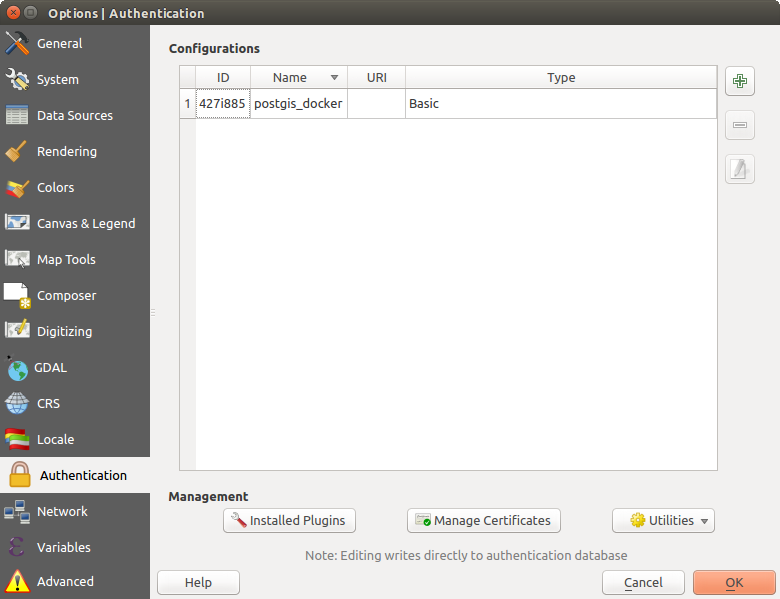
Authentication Settings in QGIS
Network Settings
General
Define WMS search address, default is
http://geopole.org/wms/search?search=\%1\&type=rssDefine Timeout for network requests (ms) - default is 60000
Define Default expiration period for WMS Capabilities (hours) - default is 24
Define Default expiration period for WMSC/WMTS tiles (hours) - default is 24
Define Max retry in case of tile or feature request errors
Define User-Agent
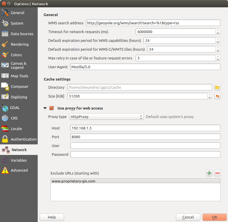
Proxy-settings in QGIS
Cache settings
Defines the Directory and a Size for the cache. Also offers tools to automatically clear the connection authentication cache on SSL errors (recommended).
Proxy for web access
- Use proxy for web access
Set the Proxy type
according to your needs and
define ‘Host’ and ‘Port’. Available proxy types are:: Proxy is determined based on system’s proxy
: Generic proxy for any kind of connection. Supports TCP, UDP, binding to a port (incoming connections) and authentication.
: Implemented using the “CONNECT” command, supports only outgoing TCP connections; supports authentication.
: Implemented using normal HTTP commands, it is useful only in the context of HTTP requests.
: Implemented using an FTP proxy, it is useful only in the context of FTP requests.
Credentials of proxy are set using the authentication widget.
Excluding some URLs can be added to the text box below the proxy settings (see Figure_Network_Tab).
If you need more detailed information about the different proxy settings, please refer to the manual of the underlying QT library documentation at https://doc.qt.io/qt-5.9/qnetworkproxy.html#ProxyType-enum
Tip
Using Proxies
Using proxies can sometimes be tricky. It is useful to proceed by ‘trial and error’ with the above proxy types, to check if they succeed in your case.
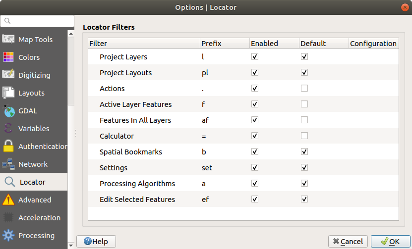
Locator Settings
 The Locator tab allows to configure the Locator bar, a
quick search widget available on the status bar that helps you perform searches
anywhere in the application. It provides some default filters (with prefix) to use:
The Locator tab allows to configure the Locator bar, a
quick search widget available on the status bar that helps you perform searches
anywhere in the application. It provides some default filters (with prefix) to use:
Project layers (
l): finds and selects a layer in the Layers panel.Project layouts (
pl): finds and opens a print layout.Actions (
.): finds and executes a QGIS action; actions can be any tool or menu in QGIS, opening a panel…Active layer features (
f): searches for matching attributes in any field from the current active layer and zooms to the selected feature.Features in all layers (
af): searches for matching attributes in the display name of each searchable layers and zooms to the selected feature.Calculator (
=): allows evaluation of any QGIS expression and, if valid, gives an option to copy the result to the clipboard.Spatial bookmarks (
b): finds and zooms to the bookmark extent.Settings (
set): browses and opens project and application-wide properties dialogs.Processing (
a): searches and opens a Processing algorithm dialog.Edit selected features (
ef): gives quick access and runs a compatible modify-in-place Processing algorithm on the active layer.
For each filter, you can customize the filter, set whether it is enabled by default or not. The set of default locator filters can be extended by plugins, eg for OSM nominatim searches, direct database searching, layer catalog searches.
The locator search bar can be activated pressing Ctrl+K. Type your text
to perform a search. By default, results are returned for all enabled locator
filters but you can limit the search to a certain filter by prefixing your
text with the locator filter prefix, ie. typing l cad will return only the
layers whose name contains cad. Click on the result to execute the
corresponding action, depending on the type of item.
Searching is handled using threads, so that results always become available as quickly as possible, regardless of whether any slow search filters may be installed. They also appear as soon as each result is encountered by each filter, which means that e.g. a file search filter will show results one by one as the file tree is scanned. This ensures that the UI is always responsive even if a very slow search filter is present (e.g. one which uses an online service).
Tip
Quick access to the locator’s configurations
Click on the icon inside the locator widget on the status bar to
display the list of filters you can use and a Configure entry that
opens the Locator tab of the menu.
Locator Settings in QGIS
Advanced Settings
Depending on your OS, all the settings related to QGIS (UI, tools, data providers, default values, plugins options…) are saved:
 in a text file:
 $HOME/.config/QGIS/QGIS2.conf in the properties list file:
 $HOME/Library/Preferences/org.qgis.qgis.plist in the registry under:
 HKEY\CURRENT_USER\Software\QGIS\qgis
The Advanced tab offers you in a single place, regardless your OS, means to manage these settings through the Advanced Settings Editor. After you promise to be careful, the widget is populated with a tree of all QGIS settings, which you can directly edit.
Warning
Avoid using the Advanced tab settings blindly
Be careful while modifying items in this dialog given that changes are automatically applied. Doing changes without knowledge can break your QGIS installation in various ways.
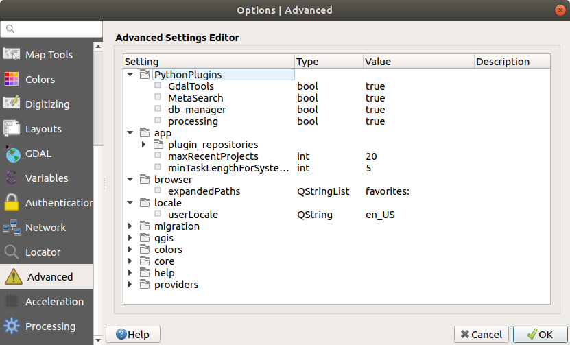
Advanced Settings tab in QGIS
Processing Settings
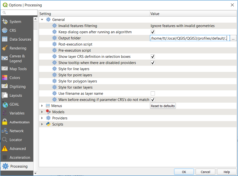
The  Processing tab provides you with general settings
of tools and data providers that are used in the QGIS Processing framework.
More information at QGIS processing framework.
Processing tab provides you with general settings
of tools and data providers that are used in the QGIS Processing framework.
More information at QGIS processing framework.
Processing Settings tab in QGIS
Working with User Profiles
The menu provides functions to set and access user profiles. A user profile is a unified application configuration that allows to store in a single folder:
all the global settings, including locale, projections, authentication settings, color palettes, shortcuts…
GUI configurations and customization
installed plugins and their configurations
project templates and history of saved project with their image preview
processing settings, logs, scripts, models.
By default, a QGIS installation contains a single user profile named default.
But you can create as many user profiles as you want:
Click the New profile… entry.
You’ll be prompted to provide a profile name, creating a folder of the same name under
~/<UserProfiles>/where:~represents the HOME directory, which on Windows is usually
something like C:\Users\(user).and
<UserProfiles>represents the main profiles folder, i.e.:-
.local/share/QGIS/QGIS3/profiles/ -
AppData\Roaming\QGIS\QGIS3\profiles\ -
Library/Application Support/QGIS/QGIS3/profiles/
The user profile folder can be opened from within QGIS using the Open Active Profile Folder.
A new instance of QGIS is started, using a clean configuration. You can then set your custom configurations.
As each user profile contains isolated settings, plugins and history they can be great for different workflows, demos, users of the same machine, or testing settings, etc. And you can switch from one to the other by selecting them in the menu. You can also run QGIS with a specific user profile from the command line.
Unless changed, the profile of the last closed QGIS session will be used in the following QGIS sessions.
Tip
Run QGIS under a new user profile to check for bug persistence
When you encounter weird behavior with some functions in QGIS, create a new user profile and run the commands again. Sometimes, bugs are related to some leftovers in the current user profile and creating a new one may fix them as it restarts QGIS with the new (clean) profile.
Project Properties
In the properties window for the project under , you can set project-specific options. The project-specific options overwrite their equivalent in the Options dialog described above.
General Properties
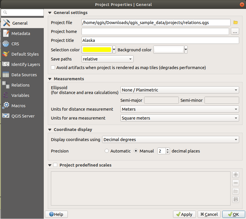
In the General tab, the General settings let you:
see the location of the project file
set the folder for the project home (available in the
Project Homeitem in the browser). The path can be relative to the folder of the project file (type it in) or absolute. The project home can be used for storing data and other content that is useful for the project.give a title to the project beside the project file path
choose the color to use for features when they are selected
choose the background color: the color to use for the map canvas
set whether the path to layers in the project should be saved as absolute (full) or as relative to the project file location. You may prefer relative path when both layers and project files can be moved or shared or if the project is accessed from computers on different platforms.
choose to avoid artifacts when project is rendered as map tiles. Note that checking this option can lead to performance degradation.
Calculating areas and distances is a common need in GIS. However, these values are really tied to the underlying projection settings. The Measurements frame lets you control these parameters. You can indeed choose:
the Ellipsoid, on which distance and area calculations are entirely based; it can be:
None/Planimetric: returned values are in this case cartesian measurements.
a Custom one: you’ll need to set values of the semi-major and semi-minor axes.
or an existing one from a predefined list (Clarke 1866, Clarke 1880 IGN, New International 1967, WGS 84…).
the units for distance measurements for length and perimeter and the units for area measurements. These settings, which default to the units set in QGIS options but then overrides it for the current project, are used in:
Attribute table field update bar
Field calculator calculations
Identify tool derived length, perimeter and area values
Default unit shown in measure dialog
The Coordinate display allows you to choose and customize the format of units to use to display the mouse coordinate in the status bar and the derived coordinates shown via the identify tool.
Finally, you can set a Project predefined scales list, which overrides the global predefined scales.
General tab of Project Properties dialog
Metadata Properties
The Metadata tab allows detailed metadata to be defined, including (among the others): author, creation date, language, abstracts, categories, keywords, contact details, links, history. There is also a validation functionality that checks if specific fields were filled, anyway this is not enforced. See vector layer metadata properties for some details.
CRS Properties
The  CRS tab helps you set the coordinate reference system
to use in this project. It can be:
CRS tab helps you set the coordinate reference system
to use in this project. It can be:
- No projection (or unknown/non-Earth projection):
this setting can be used to guess a layer CRS or when using QGIS for non
earth uses like role-playing game maps, building mapping or microscopic stuff.
In this case:
No reprojection is done while rendering the layers: features are just drawn using their raw coordinates.
The ellipsoid is locked out and forced to
None/Planimetric.The distance and area units, and the coordinate display are locked out and forced to “unknown units”; all measurements are done in unknown map units, and no conversion is possible.
or an existing coordinate reference system that can be geographic, projected or user-defined. A preview of the CRS extent on earth is displayed to help you select the appropriate one. Layers added to the project are on-the-fly translated to this CRS in order to overlay them regardless their original CRS. Use of units, ellipsoid setting are available and make sense and you can perform calculations accordingly.
The CRS tab also helps you control the layers reprojection
settings by configuring the datum transformation preferences to apply in the
current project. As usual, these override any corresponding global settings.
See Datum Transformations for more details.
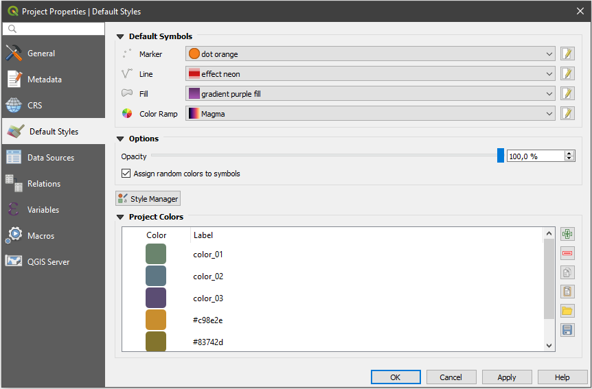
Default Styles Properties
The Default Styles tab lets you control how new layers will be
drawn in the project when they do not have an existing .qml style
defined. You can:
Set default symbols (Marker, Line, Fill) to apply depending on the layer geometry type as well as a default Color Ramp
Apply a default Opacity to new layers
- Assign random colors to symbols, modifying the symbols
fill colors, hence avoiding same rendering for all layers.
Default Styles tab
Using the Style Manager button, you can also quickly
access the Style Manager dialog and configure
symbols and color ramps.
There is also an additional section where you can define specific colors for the running project. Like the global colors, you can:
- Add or Remove color
- Copy or Paste color
- Import or Export the set of colors
from/to
.gplfile.
Double-click a color in the list to tweak or replace it in the Color Selector dialog. You can also rename it by double-clicking in the Label column.
These colors are identified as Project colors and listed as part of color widgets.
Tip
Use project colors to quickly assign and update color widgets
Project colors can be refered to using their label and the color widgets they are used in are bound to them. This means that instead of repeatedly setting the same color for many properties and, to avoid a cumbersome update you can:
Define the color as a project color
Apply it using the
project_color('color_label')expression in color data defined override widgetUpdate the color once in a Project colors list
And the change is reflected EVERYWHERE.
Data Sources Properties
In the Data Sources tab, you can:
- Automatically create transaction groups where possible:
When this mode is turned on, all
(postgres) layers from the same database are synchronised in their edit state,
i.e. when one layer is put into edit state, all are, when one layer is committed
or one layer is rolled back, so are the others. Also, instead of buffering edit
changes locally, they are directly sent to a transaction in the database which
gets committed when the user clicks save layer.
Note that you can (de)activate this option only if no layer is being edited
in the project.
- Evaluate default values on provider side: When adding
new features in a PostgreSQL table, fields with default value constraint are
evaluated and populated at the form opening, and not at the commit moment.
This means that instead of an expression like
nextval('serial'), the field in the Add Feature form will display expected value (e.g.,25). - Trust project when data source has no metadata:
To speed up project loading by skipping data checks. Useful in QGIS Server context
or in projects with huge database views/materialized views. The extent of layers
will be read from the QGIS project file (instead of data sources) and when
using the PostgreSQL provider the primary key unicity will not be
checked for views and materialized views.
Configure the Layers Capabilities, i.e.:
Set (or disable) which layers are
identifiable, i.e. will respond to the identify tool. By default, layers are set queryable.Set whether a layer should appear as
read-only, meaning that it can not be edited by the user, regardless of the data provider’s capabilities. Although this is a weak protection, it remains a quick and handy configuration to avoid end-users modifying data when working with file-based layers.Define which layers are
searchable, i.e. could be queried using the locator widget. By default, layers are set searchable.Define which layers are defined as
required. Checked layers in this list are protected from inadvertent removal from the project.
The Layers Capabilities table provides some convenient tools to:
Select multiple cells and press Toggle Selection to have them change their checkbox state;
- Show spatial layers only, filtering out non-spatial
layers from the layers list;
- Filter layers… and quickly find a particular layer to
configure.
Relations Properties
The Relations tab is used to define 1:n relations. The relations are defined in the project properties dialog. Once relations exist for a layer, a new user interface element in the form view (e.g. when identifying a feature and opening its form) will list the related entities. This provides a powerful way to express e.g. the inspection history on a length of pipeline or road segment. You can find out more about 1:n relations support in Section Creating one or many to many relations.
Variables Properties
The Variables tab lists all the variables available at
the project’s level (which includes all global variables). Besides, it
also allows the user to manage project-level variables. Click the
button to add a new custom project-level variable. Likewise, select a custom
project-level variable from the list and click the button to
remove it.
More information on variables usage in the General Tools
Storing values in Variables section.
Macros Properties
The Macros tab is used to edit Python macros for projects. Currently,
only three macros are available: openProject(), saveProject() and
closeProject().
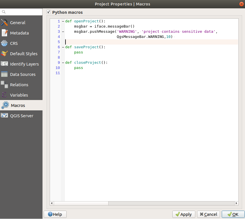
Macro settings in QGIS
QGIS Server Properties
The tab QGIS Server allows you to configure your project in order to publish it online. Here you can define information about the QGIS Server WMS and WFS capabilities, extent and CRS restrictions. More information available in section Configure your project and subsequent.
Customization
The customization dialog lets you (de)activate almost every element in the QGIS user interface. This can be very useful if you want to provide your end-users with a ‘light’ version of QGIS, containing only the icons, menus or panels they need.
Note
Before your changes are applied, you need to restart QGIS.
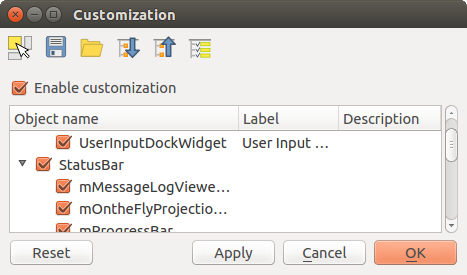
The Customization dialog
Ticking the Enable customization checkbox is the first step
on the way to QGIS customization. This enables the toolbar and the widget
panel from which you can uncheck and thus disable some GUI items.
The configurable item can be:
a Menu or some of its sub-menus from the Menu Bar
a whole Panel (see Panels and Toolbars)
the Status bar described in Status Bar or some of its items
a Toolbar: the whole bar or some of its icons
or any widget from any dialog in QGIS: label, button, combobox…
With  Switch to catching widgets in main application, you
can click on an item in QGIS interface that you want to be hidden and
QGIS automatically unchecks the corresponding entry in the Customization dialog.
Switch to catching widgets in main application, you
can click on an item in QGIS interface that you want to be hidden and
QGIS automatically unchecks the corresponding entry in the Customization dialog.
Once you setup your configuration, click Apply or OK to validate your changes. This configuration becomes the one used by default by QGIS at the next startup.
The modifications can also be saved in a .ini file using
Save To File button. This is a handy way to share a common QGIS
interface among multiple users. Just click on Load from File
from the destination computer in order to import the .ini file.
You can also run command line tools and save various
setups for different use cases as well.
Tip
Easily restore predefined QGIS
The initial QGIS GUI configuration can be restored by one of the methods below:
unchecking
Enable customization option in the
Customization dialog or click the  Check All button
pressing the Reset button in the QSettings frame under menu, System tab
launching QGIS at a command prompt with the following command line
qgis --nocustomizationsetting to
falsethe value of variable under menu, Advanced tab (see the warning).
In most cases, you need to restart QGIS in order to have the change applied.
Keyboard shortcuts
QGIS provides default keyboard shortcuts for many features. You can find them in
section Menu Bar. Additionally, the menu option
allows you to change the default keyboard shortcuts and add new
ones to QGIS features.
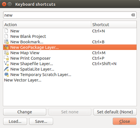
Define shortcut options
Configuration is very simple. Use the search box at the top of the dialog to find a particular action, select it from the list and click on :
Change and press the new combination you want to assign as new shortcut
Set None to clear any assigned shortcut
or Set Default to backup the shortcut to its original and default value.
Proceed as above for any other tools you wish to customize. Once you have
finished your configuration, simply Close the dialog to have your changes
applied. You can also Save the changes as an .XML file
and Load them into another QGIS installation.
Running QGIS with advanced settings
Command line and environment variables
We’ve seen that launching QGIS is done as for any
application on your OS.
QGIS provides command line options for more advanced use cases (in some cases
you can use an environment variable instead of the command line option).
To get a list of the options, enter qgis --help on the command line, which
returns:
QGIS is a user friendly Open Source Geographic Information System.
Usage: /usr/bin/qgis.bin [OPTION] [FILE]
  OPTION:
        [--version]     display version information and exit
        [--snapshot filename]   emit snapshot of loaded datasets to given file
        [--width width] width of snapshot to emit
        [--height height]       height of snapshot to emit
        [--lang language]       use language for interface text (changes existing override)
        [--project projectfile] load the given QGIS project
        [--extent xmin,ymin,xmax,ymax]  set initial map extent
        [--nologo]      hide splash screen
        [--noversioncheck]      don't check for new version of QGIS at startup
        [--noplugins]   don't restore plugins on startup
        [--nocustomization]     don't apply GUI customization
        [--customizationfile path]      use the given ini file as GUI customization
        [--globalsettingsfile path]     use the given ini file as Global Settings (defaults)
        [--authdbdirectory path] use the given directory for authentication database
        [--code path]   run the given python file on load
        [--defaultui]   start by resetting user ui settings to default
        [--hide-browser]        hide the browser widget
        [--dxf-export filename.dxf]     emit dxf output of loaded datasets to given file
        [--dxf-extent xmin,ymin,xmax,ymax]      set extent to export to dxf
        [--dxf-symbology-mode none|symbollayer|feature] symbology mode for dxf output
        [--dxf-scale-denom scale]       scale for dxf output
        [--dxf-encoding encoding]       encoding to use for dxf output
        [--dxf-map-theme maptheme]      map theme to use for dxf output
        [--take-screenshots output_path]        take screen shots for the user documentation
        [--screenshots-categories categories]   specify the categories of screenshot to be used (see QgsAppScreenShots::Categories).
        [--profile name]        load a named profile from the user's profiles folder.
        [--profiles-path path]  path to store user profile folders. Will create profiles inside a {path}\profiles folder
        [--version-migration]   force the settings migration from older version if found
        [--openclprogramfolder]         path to the folder containing the sources for OpenCL programs.
        [--help]                this text
        [--]            treat all following arguments as FILEs

  FILE:
    Files specified on the command line can include rasters,
    vectors, and QGIS project files (.qgs and .qgz):
     1. Rasters - supported formats include GeoTiff, DEM
        and others supported by GDAL
     2. Vectors - supported formats include ESRI Shapefiles
        and others supported by OGR and PostgreSQL layers using
        the PostGIS extension
Tip
Example Using command line arguments
You can start QGIS by specifying one or more data files on the command
line. For example, assuming you are in the qgis_sample_data
directory, you could start QGIS with a vector layer and a raster file
set to load on startup using the following command:
qgis ./raster/landcover.img ./gml/lakes.gml
--version
This option returns QGIS version information.
--snapshot
This option allows you to create a snapshot in PNG format from the current view. This comes in handy when you have many projects and want to generate snapshots from your data, or when you need to create snapshots of the same project with updated data.
Currently, it generates a PNG file with 800x600 pixels. The size can be adjusted
using the --width and --height arguments. The filename can
be added after --snapshot. For example:
qgis --snapshot my_image.png --width 1000 --height 600 --project my_project.qgs
--width
This option returns the width of the snapshot to be emitted (used with --snapshot).
--height
This option returns the height of the snapshot to be emitted (used with --snapshot).
--lang
Based on your locale, QGIS selects the correct localization. If you would like
to change your language, you can specify a language code. For example,
qgis --lang it starts QGIS in Italian localization.
--project
Starting QGIS with an existing project file is also possible. Just add the
command line option --project followed by your project name and QGIS will
open with all layers in the given file loaded.
--extent
To start with a specific map extent use this option. You need to add the bounding box of your extent in the following order separated by a comma:
--extent xmin,ymin,xmax,ymax
This option probably makes more sense when paired with the --project option
to open a specific project at the desired extent.
--nologo
This option hides the splash screen when you start QGIS.
--noversioncheck
Skip searching for a new version of QGIS at startup.
--noplugins
If you have trouble at start-up with plugins, you can avoid loading them at start-up with this option. They will still be available from the Plugins Manager afterwards.
--nocustomization
Using this option, any existing GUI customization will not be applied at startup. This means that any hidden buttons, menu items, toolbars, and so on, will show up on QGIS start up. This is not a permanent change. The customization will be applied again if QGIS is launched without this option.
This option is useful for temporarily allowing access to tools that have been removed by customization.
--customizationfile
Using this option, you can define a UI customization file, that will be used at startup.
--globalsettingsfile
Using this option, you can specify the path for a Global Settings
file (.ini), also known as the Default Settings. The settings in the specified
file replace the original inline default ones, but the user profiles’
settings will be set on top of those. The default global settings is located in
your_QGIS_PKG_path/resources/qgis_global_settings.ini.
Presently, there’s no way to specify a file to write settings to; therefore, you can create a copy of an original settings file, rename, and adapt it.
Setting the qgis_global_setting.ini file path to a network shared
folder, allows a system administrator to change global settings and defaults in
several machines by only editing one file.
The equivalent environment variable is QGIS_GLOBAL_SETTINGS_FILE.
--authdbdirectory
This option is similar to --globalsettingsfile, but defines the path to the
directory where the authentication database will be stored and loaded.
--code
This option can be used to run a given python file directly after QGIS has started.
For example, when you have a python file named load_alaska.py with
following content:
from qgis.utils import iface
raster_file = "/home/gisadmin/Documents/qgis_sample_data/raster/landcover.img"
layer_name = "Alaska"
iface.addRasterLayer(raster_file, layer_name)
Assuming you are in the directory where the file load_alaska.py is
located, you can start QGIS, load the raster file landcover.img and give
the layer the name ‘Alaska’ using the following command:
qgis --code load_alaska.py
--defaultui
On load, permanently resets the user interface (UI) to the default settings. This option will restore the panels and toolbars visibility, position, and size. Unless it’s changed again, the default UI settings will be used in the following sessions.
Notice that this option doesn’t have any effect on GUI
customization. Items hidden by GUI customization (e.g. the
status bar) will remain hidden even using the --defaultui option. See also
the --nocustomization option.
--hide-browser
On load, hides the Browser panel from the user interface. The panel
can be enabled by right-clicking a space in the toolbars or using the
( in  Linux KDE).
Unless it’s enabled again, the Browser panel will remain hidden in the following sessions.
--dxf-*
These options can be used to export a QGIS project into a DXF file. Several options are available:
–dxf-export: the DXF filename into which to export the layers;
–dxf-extent: the extent of the final DXF file;
–dxf-symbology-mode: several values can be used here:
none(no symbology),symbollayer(Symbol layer symbology),feature(feature symbology);–dxf-scale-denom: the scale denominator of the symbology;
–dxf-encoding: the file encoding;
–dxf-map-theme: choose a map theme from the layer tree configuration.
--take-screenshots
Takes screenshots for the user documentation. Can be used together with
--screenshots-categories to filter which categories/sections of the
documentation screenshots should be created (see QgsAppScreenShots::Categories).
--profile
Loads QGIS using a specific profile from the user’s profile folder. Unless changed, the selected profile will be used in the following QGIS sessions.
--profiles-path
With this option, you can choose a path to load and save the profiles (user
settings). It creates profiles inside a {path}\profiles folder, which
includes settings, installed plugins, processing models and scripts, and so on.
This option allows you to, for instance, carry all your plugins and settings in a flash drive, or, for example, share the settings between different computers using a file sharing service.
The equivalent environment variable is QGIS_CUSTOM_CONFIG_PATH.
--version-migration
If settings from an older version are found (e.g., the .qgis2 folder from QGIS
2.18), this option will import them into the default QGIS profile.
--openclprogramfolder
Using this option, you can specify an alternative path for your OpenCL programs. This is useful for developers while testing new versions of the programs without needing to replace the existing ones.
The equivalent environment variable is QGIS_OPENCL_PROGRAM_FOLDER.
Deploying QGIS within an organization
If you need to deploy QGIS within an organization with a custom configuration file,
first you need to copy/paste the content of the default settings file located in
your_QGIS_PKG_path/resources/qgis_global_settings.ini. This file already
contains some default sections identified by a block starting with [].
We recommend that you keep these defaults values and add your own sections at the bottom
of the file. If a section is duplicated in the file, QGIS will take the last
one from top to bottom.
You can change allowVersionCheck=false to disable
the QGIS version check.
If you do not want to display the migration window after a fresh install, you need the following section:
[migration]
fileVersion=2
settings=true
If you want to add a custom variable in the global scope:
[variables]
organisation="Your organization"
To discover all possibilities of the settings INI file, we suggest that you set
the config you would like in QGIS Desktop and then search for it in your INI
file located in your profile using a text editor. A lot of settings can be set
using the INI file such as WMS/WMTS, PostGIS connections, proxy settings, maptips…
Finally, you need to set the environment variable QGIS_GLOBAL_SETTINGS_FILE
to the path of your customized file.
In addition, you can also deploy files such as Python macros, color palettes, layout templates, project templates… either in the QGIS system directory or in the QGIS user profile.
Layout templates must be deployed in the
composer_templatesdirectory.Project templates must be deployed in the
project_templatesdirectory.Custom Python macros must be deployed in the
pythondirectory.