27.1.14. Raster tools
27.1.14.1. Convert map to raster
Creates a raster image of map canvas content.
A map theme can be selected to render a predetermined set of layers with a defined style for each layer.
Alternatively, a single layer can be selected if no map theme is set.
If neither map theme nor layer is set, the current map content will be rendered. The minimum extent entered will internally be extended to be a multiple of the tile size.
Parametri
Etichetă |
Nume |
Tipul |
Descriere |
|---|---|---|---|
Minimum extent to render (xmin, xmax, ymin, ymax) |
|
[extent] |
Specify the extent of the output raster layer. It will internally be extended to a multiple of the tile size. Metodele disponibile sunt:
|
Tile size |
|
[număr] Implicit: 1024 |
Size of the tile of the output raster layer. Minimum value: 64. |
Map units per pixel |
|
[număr] Implicit: 100.0 |
Pixel size (in map units). Minimum value: 0.0 |
Make background transparent |
|
[boolean] Implicit: False |
Allows exporting the map with a transparent background.
Outputs an RGBA (instead of RGB) image if set to |
Map theme to render Opţional |
|
[enumerare] |
Use an existing map theme for the rendering. |
Single layer to render Opţional |
|
[enumerare] |
Choose a single layer for the rendering |
Output layer |
|
[raster] Implicit: |
Specification of the output raster. One of:
|
Rezultat
Etichetă |
Nume |
Tipul |
Descriere |
|---|---|---|---|
Output layer |
|
[raster] |
Stratul raster de ieșire |
Cod Python
Algorithm ID: native:rasterize
import processing
processing.run("algorithm_id", {parameter_dictionary})
ID-ul algoritmului se afișează atunci când treceți peste algoritmul din caseta instrumentelor de procesare. Dicționarul parametrilor furnizează valorile și NUMELE parametrilor. Pentru detalii despre rularea algoritmilor de procesare din consola Python, parcurgeți Utilizarea algoritmilor de procesare din consolă.
27.1.14.2. Umplere celule NoData
Resets the NoData values in the input raster to a chosen value, resulting in raster dataset with no NoData pixels.
The algorithm respects the input raster data type, e.g. a floating point fill value will be truncated when applied to an integer raster.
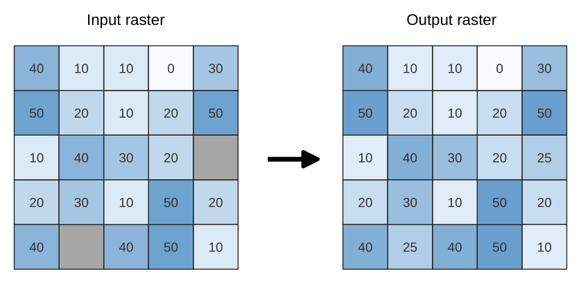
Fig. 27.30 Filling NoData values (in grey) of a raster
Parametri
Etichetă |
Nume |
Tipul |
Descriere |
|---|---|---|---|
Input raster |
|
[raster] |
The raster to process. |
Numărul benzii |
|
[număr] Implicit: 1 |
The band of the raster |
Fill value |
|
[număr] Implicit: 1.0 |
Set the value to use for the NoData pixels |
Raster de ieșire |
|
[raster] Implicit: |
Specification of the output raster. One of:
|
Rezultat
Etichetă |
Nume |
Tipul |
Descriere |
|---|---|---|---|
Raster de ieșire |
|
[raster] |
The output raster layer with filled data cells. |
Cod Python
ID Algorithm: nativ:fillnodata
import processing
processing.run("algorithm_id", {parameter_dictionary})
ID-ul algoritmului se afișează atunci când treceți peste algoritmul din caseta instrumentelor de procesare. Dicționarul parametrilor furnizează valorile și NUMELE parametrilor. Pentru detalii despre rularea algoritmilor de procesare din consola Python, parcurgeți Utilizarea algoritmilor de procesare din consolă.
27.1.14.3. Generate XYZ tiles (Directory)
Generates raster “XYZ” tiles using the current QGIS project as individual images to a directory structure.
Parametri
Etichetă |
Nume |
Tipul |
Descriere |
|---|---|---|---|
Extent (xmin, xmax, ymin, ymax) |
|
[extent] |
Specify the extent of the tiles. It will internally be extended to a multiple of the tile size. Metodele disponibile sunt:
|
Minimum zoom |
|
[număr] Implicit: 12 |
Minimum 0, maximum 25. |
Maximum zoom |
|
[număr] Implicit: 12 |
Minimum 0, maximum 25. |
DPI |
|
[număr] Implicit: 96 |
Minimum 48, maximum 600. |
Background color Opţional |
|
[color] Implicit: QColor(0, 0, 0, 0) |
Choose the background color for the tiles |
Tile format |
|
[enumerare] Implicit: 0 |
One of:
|
Quality (JPG only) Opţional |
|
[număr] Implicit: 75 |
Minimum 1, maximum 100. |
Metatile size Opţional |
|
[număr] Implicit: 4 |
Specify a custom metatile size when generating XYZ tiles. Larger values may speed up the rendering of tiles and provide better labelling (fewer gaps without labels) at the expense of using more memory. Minimum 1, maximum 20. |
Tile width Opţional |
|
[număr] Implicit: 256 |
Minimum 1, maximum 4096. |
Tile height Opţional |
|
[număr] Implicit: 256 |
Minimum 1, maximum 4096. |
Use inverted tile Y axis (TMS conventions) Opţional |
|
[boolean] Implicit: False |
|
Director de ieșire Opţional |
|
[folder] Implicit: |
Specification of the output directory (for the tiles). One of:
|
Output html (Leaflet) Opţional |
|
[html] Implicit: |
Specification of the output HTML file. One of:
|
Rezultat
Etichetă |
Nume |
Tipul |
Descriere |
|---|---|---|---|
Director de ieșire |
|
[folder] |
Output directory (for the tiles) |
Output html (Leaflet) |
|
[html] |
The output HTML (Leaflet) file |
Cod Python
Algorithm ID: qgis:tilesxyzdirectory
import processing
processing.run("algorithm_id", {parameter_dictionary})
ID-ul algoritmului se afișează atunci când treceți peste algoritmul din caseta instrumentelor de procesare. Dicționarul parametrilor furnizează valorile și NUMELE parametrilor. Pentru detalii despre rularea algoritmilor de procesare din consola Python, parcurgeți Utilizarea algoritmilor de procesare din consolă.
27.1.14.4. Generate XYZ tiles (MBTiles)
Generates raster “XYZ” tiles using the current QGIS project as a single file in the “MBTiles” format.
Parametri
Etichetă |
Nume |
Tipul |
Descriere |
|---|---|---|---|
Extent (xmin, xmax, ymin, ymax) |
|
[extent] |
Specify the extent of the tiles. It will internally be extended to a multiple of the tile size. Metodele disponibile sunt:
|
Minimum zoom |
|
[număr] Implicit: 12 |
Minimum 0, maximum 25. |
Maximum zoom |
|
[număr] Implicit: 12 |
Minimum 0, maximum 25. |
DPI |
|
[număr] Implicit: 96 |
Minimum 48, maximum 600. |
Background color Opţional |
|
[color] Implicit: QColor(0, 0, 0, 0) |
Choose the background color for the tiles |
Tile format |
|
[enumerare] Implicit: 0 |
One of:
|
Quality (JPG only) Opţional |
|
[număr] Implicit: 75 |
Minimum 1, maximum 100. |
Metatile size Opţional |
|
[număr] Implicit: 4 |
Specify a custom metatile size when generating XYZ tiles. Larger values may speed up the rendering of tiles and provide better labelling (fewer gaps without labels) at the expense of using more memory. Minimum 1, maximum 20. |
Output file (for MBTiles) |
|
[file] Implicit: |
Specification of the output file. One of:
|
Rezultat
Etichetă |
Nume |
Tipul |
Descriere |
|---|---|---|---|
Output file (for MBTiles) |
|
[file] |
The output file. |
Cod Python
Algorithm ID: qgis:tilesxyzmbtiles
import processing
processing.run("algorithm_id", {parameter_dictionary})
ID-ul algoritmului se afișează atunci când treceți peste algoritmul din caseta instrumentelor de procesare. Dicționarul parametrilor furnizează valorile și NUMELE parametrilor. Pentru detalii despre rularea algoritmilor de procesare din consola Python, parcurgeți Utilizarea algoritmilor de procesare din consolă.