27.1.14. Raster tools
27.1.14.1. Convert map to raster
Creates a raster image of map canvas content.
A map theme can be selected to render a predetermined set of layers with a defined style for each layer.
Alternatively, a single layer can be selected if no map theme is set.
If neither map theme nor layer is set, the current map content will be rendered. The minimum extent entered will internally be extended to be a multiple of the tile size.
Параметры
Ярлык |
Имя |
Тип |
Описание |
|---|---|---|---|
Minimum extent to render (xmin, xmax, ymin, ymax) |
|
[extent] |
Specify the extent of the output raster layer. It will internally be extended to a multiple of the tile size. Available methods are:
|
Tile size |
|
[number] Default: 1024 |
Size of the tile of the output raster layer. Minimum value: 64. |
Map units per pixel |
|
[number] Default: 100.0 |
Pixel size (in map units). Minimum value: 0.0 |
Make background transparent |
|
[логическое значение] По умолчанию: Ложь |
Allows exporting the map with a transparent background.
Outputs an RGBA (instead of RGB) image if set to |
Map theme to render Optional |
|
[enumeration] |
Use an existing map theme for the rendering. |
Single layer to render Optional |
|
[enumeration] |
Choose a single layer for the rendering |
Output layer |
|
[растр] По умолчанию: |
Specification of the output raster. One of:
|
Результаты
Ярлык |
Имя |
Тип |
Описание |
|---|---|---|---|
Output layer |
|
[растр] |
Output raster layer |
Код на Python
Algorithm ID: native:rasterize
import processing
processing.run("algorithm_id", {parameter_dictionary})
ID алгоритма отображается при наведении мыши на алгоритм в Инструментах анализа. Словарь parameter dictionary содержит ключи параметров и их значения. См. Изпользование алгоритмов геообработки в консоли для детального описания того, как запускать алгоритмы анализа из консоли Python.
27.1.14.2. Fill NoData cells
Resets the NoData values in the input raster to a chosen value, resulting in raster dataset with no NoData pixels.
The algorithm respects the input raster data type, e.g. a floating point fill value will be truncated when applied to an integer raster.
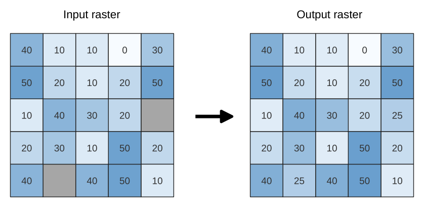
Рис. 27.30 Filling NoData values (in grey) of a raster
Параметры
Ярлык |
Имя |
Тип |
Описание |
|---|---|---|---|
Input raster |
|
[растр] |
The raster to process. |
Номер канала |
|
[number] Default: 1 |
The band of the raster |
Fill value |
|
[number] Default: 1.0 |
Set the value to use for the NoData pixels |
Output raster |
|
[растр] По умолчанию: |
Specification of the output raster. One of:
|
Результаты
Ярлык |
Имя |
Тип |
Описание |
|---|---|---|---|
Output raster |
|
[растр] |
The output raster layer with filled data cells. |
Код на Python
Algorithm ID: native:fillnodata
import processing
processing.run("algorithm_id", {parameter_dictionary})
ID алгоритма отображается при наведении мыши на алгоритм в Инструментах анализа. Словарь parameter dictionary содержит ключи параметров и их значения. См. Изпользование алгоритмов геообработки в консоли для детального описания того, как запускать алгоритмы анализа из консоли Python.
27.1.14.3. Generate XYZ tiles (Directory)
Generates raster “XYZ” tiles using the current QGIS project as individual images to a directory structure.
Параметры
Ярлык |
Имя |
Тип |
Описание |
|---|---|---|---|
Extent (xmin, xmax, ymin, ymax) |
|
[extent] |
Specify the extent of the tiles. It will internally be extended to a multiple of the tile size. Available methods are:
|
Minimum zoom |
|
[number] Default: 12 |
Minimum 0, maximum 25. |
Maximum zoom |
|
[number] Default: 12 |
Minimum 0, maximum 25. |
DPI |
|
[number] Default: 96 |
Minimum 48, maximum 600. |
Background color Optional |
|
[color] Default: QColor(0, 0, 0, 0) |
Choose the background color for the tiles |
Tile format |
|
[enumeration] Default: 0 |
One of:
|
Quality (JPG only) Optional |
|
[number] Default: 75 |
Minimum 1, maximum 100. |
Metatile size Optional |
|
[number] Default: 4 |
Specify a custom metatile size when generating XYZ tiles. Larger values may speed up the rendering of tiles and provide better labelling (fewer gaps without labels) at the expense of using more memory. Minimum 1, maximum 20. |
Tile width Optional |
|
[number] Default: 256 |
Minimum 1, maximum 4096. |
Tile height Optional |
|
[number] Default: 256 |
Minimum 1, maximum 4096. |
Use inverted tile Y axis (TMS conventions) Optional |
|
[логическое значение] По умолчанию: Ложь |
|
Output directory Optional |
|
[folder] Default: |
Specification of the output directory (for the tiles). One of:
|
Output html (Leaflet) Optional |
|
[html] По умолчанию: |
Specification of the output HTML file. One of:
|
Результаты
Ярлык |
Имя |
Тип |
Описание |
|---|---|---|---|
Output directory |
|
[folder] |
Output directory (for the tiles) |
Output html (Leaflet) |
|
[html] |
The output HTML (Leaflet) file |
Код на Python
Algorithm ID: qgis:tilesxyzdirectory
import processing
processing.run("algorithm_id", {parameter_dictionary})
ID алгоритма отображается при наведении мыши на алгоритм в Инструментах анализа. Словарь parameter dictionary содержит ключи параметров и их значения. См. Изпользование алгоритмов геообработки в консоли для детального описания того, как запускать алгоритмы анализа из консоли Python.
27.1.14.4. Generate XYZ tiles (MBTiles)
Generates raster “XYZ” tiles using the current QGIS project as a single file in the “MBTiles” format.
Параметры
Ярлык |
Имя |
Тип |
Описание |
|---|---|---|---|
Extent (xmin, xmax, ymin, ymax) |
|
[extent] |
Specify the extent of the tiles. It will internally be extended to a multiple of the tile size. Available methods are:
|
Minimum zoom |
|
[number] Default: 12 |
Minimum 0, maximum 25. |
Maximum zoom |
|
[number] Default: 12 |
Minimum 0, maximum 25. |
DPI |
|
[number] Default: 96 |
Minimum 48, maximum 600. |
Background color Optional |
|
[color] Default: QColor(0, 0, 0, 0) |
Choose the background color for the tiles |
Tile format |
|
[enumeration] Default: 0 |
One of:
|
Quality (JPG only) Optional |
|
[number] Default: 75 |
Minimum 1, maximum 100. |
Metatile size Optional |
|
[number] Default: 4 |
Specify a custom metatile size when generating XYZ tiles. Larger values may speed up the rendering of tiles and provide better labelling (fewer gaps without labels) at the expense of using more memory. Minimum 1, maximum 20. |
Output file (for MBTiles) |
|
[файл] По умолчанию: |
Указание выходного файла. Одно из следующих значений:
|
Результаты
Ярлык |
Имя |
Тип |
Описание |
|---|---|---|---|
Output file (for MBTiles) |
|
[файл] |
The output file. |
Код на Python
Algorithm ID: qgis:tilesxyzmbtiles
import processing
processing.run("algorithm_id", {parameter_dictionary})
ID алгоритма отображается при наведении мыши на алгоритм в Инструментах анализа. Словарь parameter dictionary содержит ключи параметров и их значения. См. Изпользование алгоритмов геообработки в консоли для детального описания того, как запускать алгоритмы анализа из консоли Python.