27.1.6. Layer tools
27.1.6.1. Export layer(s) information
Creates a polygon layer with features corresponding to the extent of selected layer(s).
Additional layer details (CRS, provider name, file path, layer name, subset filter, abstract and attribution) are attached as attributes to each feature.
Параметры
Ярлык |
Имя |
Тип |
Описание |
|---|---|---|---|
Input layers |
|
[vector: any] [list] |
Input vector layers to get information on. |
Вывод |
|
[vector: polygon] Default: |
Specification of the output layer with information. One of:
The file encoding can also be changed here. |
Результаты
Ярлык |
Имя |
Тип |
Описание |
|---|---|---|---|
Вывод |
|
[vector: polygon] |
Polygon vector layer showing extent of input layers and associated information in attributes. |
Код на Python
Algorithm ID: native:exportlayersinformation
import processing
processing.run("algorithm_id", {parameter_dictionary})
ID алгоритма отображается при наведении мыши на алгоритм в Инструментах анализа. Словарь parameter dictionary содержит ключи параметров и их значения. См. Изпользование алгоритмов геообработки в консоли для детального описания того, как запускать алгоритмы анализа из консоли Python.
27.1.6.2. Export to spreadsheet
Exports the attributes of a selection of vector layers into a spreadsheet document or optionally appends them to an existing spreadsheet as additional sheets.
Параметры
Ярлык |
Имя |
Тип |
Описание |
|---|---|---|---|
Input layers |
|
[vector: any] [list] |
Input vector layers. The output spreadsheet will consist of a sheet, for each layer, that contains the attributes of this layer. |
Use field aliases as column headings |
|
[логическое значение] По умолчанию: Ложь |
Use the field aliases from the attribute table for the spreadsheet. |
Export formatted values instead of raw values |
|
[логическое значение] По умолчанию: Ложь |
If |
Overwrite existing spreadsheet |
|
[логическое значение] Default: True |
If the specified spreadsheet exists, setting this option to |
Destination spreadsheet |
|
[файл] По умолчанию: |
Output spreadsheet with a sheet for every layer. One of:
|
Результаты
Ярлык |
Имя |
Тип |
Описание |
|---|---|---|---|
Destination spreadsheet |
|
[файл] |
Spreadsheet with a sheet for every layer. |
Layers within spreadsheet |
|
[list] |
The list of sheets added to the spreadsheet. |
Код на Python
Algorithm ID: native:exporttospreadsheet
import processing
processing.run("algorithm_id", {parameter_dictionary})
ID алгоритма отображается при наведении мыши на алгоритм в Инструментах анализа. Словарь parameter dictionary содержит ключи параметров и их значения. См. Изпользование алгоритмов геообработки в консоли для детального описания того, как запускать алгоритмы анализа из консоли Python.
27.1.6.3. Extract layer extent
Generates a vector layer with the minimum bounding box (rectangle with N-S orientation) that covers all the input features.
The output layer contains a single bounding box for the whole input layer.
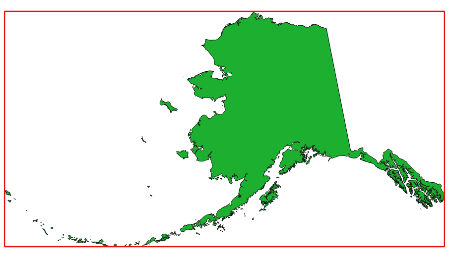
Рис. 27.7 In red the bounding box of the source layer
Default menu:
Параметры
Ярлык |
Имя |
Тип |
Описание |
|---|---|---|---|
Layer |
|
[layer] |
Input layer |
Extent |
|
[vector: polygon] Default: |
Specify the polygon vector layer for the output extent. One of:
The file encoding can also be changed here. |
Результаты
Ярлык |
Имя |
Тип |
Описание |
|---|---|---|---|
Extent |
|
[vector: polygon] |
Output (polygon) vector layer with the extent (minimum bounding box) |
Код на Python
Algorithm ID: qgis:polygonfromlayerextent
import processing
processing.run("algorithm_id", {parameter_dictionary})
ID алгоритма отображается при наведении мыши на алгоритм в Инструментах анализа. Словарь parameter dictionary содержит ключи параметров и их значения. См. Изпользование алгоритмов геообработки в консоли для детального описания того, как запускать алгоритмы анализа из консоли Python.