Важно
Translation is a community effort you can join. This page is currently translated at 47.36%.
28.1.13. Point Cloud Data Management
NEW in 3.32
28.1.13.1. Assign projection
Assigns a Coordinate Reference System to a point cloud layer, if it is missing or wrong. A new layer is created.
См.также
Параметры
Ярлык |
Имя |
Тип |
Описание |
|---|---|---|---|
Исходный слой |
|
[point cloud] |
Input point cloud layer to assign a CRS to |
Desired CRS |
|
[crs] |
The CRS to apply to the layer |
Output layer |
|
[point cloud] По умолчанию: |
Specify the point cloud file to use as output. One of:
|
Результаты
Ярлык |
Имя |
Тип |
Описание |
|---|---|---|---|
Converted |
|
[point cloud] |
Output point cloud layer with a new CRS.
Currently supported formats are |
Код на Python
Algorithm ID: pdal:assignprojection
import processing
processing.run("algorithm_id", {parameter_dictionary})
ID алгоритма отображается при наведении мыши на алгоритм в Инструментах анализа. Словарь parameter dictionary содержит ключи параметров и их значения. См. Изпользование алгоритмов геообработки в консоли для детального описания того, как запускать алгоритмы анализа из консоли Python.
28.1.13.2. Build virtual point cloud (VPC)
Creates a virtual point cloud (VPC) from input point cloud data.
If you leave the optional parameters unchecked, the VPC file will be built very quickly as the algorithm will only read metadata of input files. With any of the optional parameters set, the algorithm will read all points which can take some time.

Рис. 28.13 Generating Virtual Point Cloud with overview from a set of point cloud tiles
См.также
Параметры
Ярлык |
Имя |
Тип |
Описание |
|---|---|---|---|
Input layers |
|
[point cloud] [list] |
Input point cloud layers to combine inside a virtual point cloud layer |
Calculate boundary polygon |
|
[логическое значение] По умолчанию: Ложь |
Set to True to show the exact boundaries of data (rather than just rectangular extent) |
Calculate statistics |
|
[логическое значение] По умолчанию: Ложь |
Set to True to understand ranges of values of the various attributes |
Build overview point cloud |
|
[логическое значение] По умолчанию: Ложь |
Generates a single “thinned” point cloud of all the input data (using only every 1000th point from original data). The overview point cloud will be created next to the VPC file -
for example, for |
Virtual point cloud |
|
[point cloud] По умолчанию: |
Specify the point cloud file to build the data into. One of:
|
Результаты
Ярлык |
Имя |
Тип |
Описание |
|---|---|---|---|
Virtual point cloud |
|
[растр] |
Output point cloud layer combining all the input data, as a virtual file. |
Код на Python
Algorithm ID: pdal:virtualpointcloud
import processing
processing.run("algorithm_id", {parameter_dictionary})
ID алгоритма отображается при наведении мыши на алгоритм в Инструментах анализа. Словарь parameter dictionary содержит ключи параметров и их значения. См. Изпользование алгоритмов геообработки в консоли для детального описания того, как запускать алгоритмы анализа из консоли Python.
28.1.13.3. Clip
Clips a point cloud layer by a polygon layer so that the resulting point cloud contains only points within the polygons.
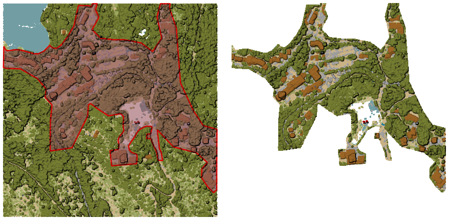
Рис. 28.14 Clipping an input point cloud layer with a polygon coverage
Параметры
Basic parameters
Ярлык |
Имя |
Тип |
Описание |
|---|---|---|---|
Исходный слой |
|
[point cloud] |
Input point cloud layer to clip |
Clipping polygons |
|
[vector: polygon] |
Polygon vector layer to use as coverage for clipping the points |
Clipped |
|
[point cloud] По умолчанию: |
Specify the point cloud file to export the clipped points to. One of:
|
Advanced parameters
Ярлык |
Имя |
Тип |
Описание |
|---|---|---|---|
Filter expression Optional |
|
[expression] |
A PDAL expression for selecting a subset of features in the point cloud data |
Cropping extent Optional |
|
[extent] |
A map extent for selecting a subset of features in the point cloud data Available methods are:
|
Результаты
Ярлык |
Имя |
Тип |
Описание |
|---|---|---|---|
Clipped |
|
[растр] |
Output point cloud whose features are the points within the coverage polygon layer. |
Код на Python
Algorithm ID: pdal:clip
import processing
processing.run("algorithm_id", {parameter_dictionary})
ID алгоритма отображается при наведении мыши на алгоритм в Инструментах анализа. Словарь parameter dictionary содержит ключи параметров и их значения. См. Изпользование алгоритмов геообработки в консоли для детального описания того, как запускать алгоритмы анализа из консоли Python.
28.1.13.4. Create COPC
Creates the index for all the input point cloud files in a batch mode.
Параметры
Ярлык |
Имя |
Тип |
Описание |
|---|---|---|---|
Input layers |
|
[point cloud] [list] |
Input point cloud layers to create an index for |
Output directory Optional |
|
[folder] Default: |
Specify the folder to create the new files in. One of:
|
Результаты
Ярлык |
Имя |
Тип |
Описание |
|---|---|---|---|
Output directory |
|
[folder] |
Output folder containing point cloud layers with accompanying COPC index files. |
Код на Python
Algorithm ID: pdal:createcopc
import processing
processing.run("algorithm_id", {parameter_dictionary})
ID алгоритма отображается при наведении мыши на алгоритм в Инструментах анализа. Словарь parameter dictionary содержит ключи параметров и их значения. См. Изпользование алгоритмов геообработки в консоли для детального описания того, как запускать алгоритмы анализа из консоли Python.
28.1.13.5. Information
Outputs basic metadata from an input point cloud file.
Example of output information:
LAS           1.4
point format  6
count         56736130
scale         0.001 0.001 0.001
offset        431749.999 5440919.999 968.898
extent        431250 5440420 424.266
              432249.999 5441419.999 1513.531
crs           ETRS89 / UTM zone 34N (N-E) (EPSG:3046)  (vertical CRS missing!)
units         horizontal=metre  vertical=unknown

Attributes:
- X floating 8
- Y floating 8
- Z floating 8
- Intensity unsigned 2
- ReturnNumber unsigned 1
- NumberOfReturns unsigned 1
- ScanDirectionFlag unsigned 1
- EdgeOfFlightLine unsigned 1
- Classification unsigned 1
- ScanAngleRank floating 4
- UserData unsigned 1
- PointSourceId unsigned 2
- GpsTime floating 8
- ScanChannel unsigned 1
- ClassFlags unsigned 1
Параметры
Ярлык |
Имя |
Тип |
Описание |
|---|---|---|---|
Исходный слой |
|
[point cloud] |
Input point cloud layer to extract metadata information from |
Layer information |
|
[файл] По умолчанию: |
Specify the file to store the metadata information. One of:
|
Результаты
Ярлык |
Имя |
Тип |
Описание |
|---|---|---|---|
Layer information |
|
[vector] |
|
Код на Python
Algorithm ID: pdal:info
import processing
processing.run("algorithm_id", {parameter_dictionary})
ID алгоритма отображается при наведении мыши на алгоритм в Инструментах анализа. Словарь parameter dictionary содержит ключи параметров и их значения. См. Изпользование алгоритмов геообработки в консоли для детального описания того, как запускать алгоритмы анализа из консоли Python.
28.1.13.6. Merge
Merges multiple point cloud files into a single one.
См.также
Параметры
Basic parameters
Ярлык |
Имя |
Тип |
Описание |
|---|---|---|---|
Input layers |
|
[point cloud] [list] |
Input point cloud layers to merge into a single one |
Merged |
|
[point cloud] По умолчанию: |
Specify the output point cloud merging input files. One of:
|
Advanced parameters
Ярлык |
Имя |
Тип |
Описание |
|---|---|---|---|
Filter expression Optional |
|
[expression] |
A PDAL expression for selecting a subset of features in the point cloud data |
Cropping extent Optional |
|
[extent] |
A map extent for selecting a subset of features in the point cloud data Available methods are:
|
Результаты
Ярлык |
Имя |
Тип |
Описание |
|---|---|---|---|
Merged |
|
[point cloud] |
Output point cloud layer merging all the input files. |
Код на Python
Algorithm ID: pdal:merge
import processing
processing.run("algorithm_id", {parameter_dictionary})
ID алгоритма отображается при наведении мыши на алгоритм в Инструментах анализа. Словарь parameter dictionary содержит ключи параметров и их значения. См. Изпользование алгоритмов геообработки в консоли для детального описания того, как запускать алгоритмы анализа из консоли Python.
28.1.13.7. Reproject
Reprojects a point cloud to a different Coordinate Reference System (CRS).
См.также
Параметры
Ярлык |
Имя |
Тип |
Описание |
|---|---|---|---|
Исходный слой |
|
[point cloud] |
Input point cloud layer to reproject to a different CRS |
Target CRS |
|
[crs] |
The CRS to apply to the layer |
Reprojected |
|
[point cloud] По умолчанию: |
Specify the reprojected point cloud file. One of:
|
Advanced parameters
Ярлык |
Имя |
Тип |
Описание |
|---|---|---|---|
Coordinate operation Optional |
|
[datum] |
The datum transformation to use to reproject the data between the origin and target systems. |
Результаты
Ярлык |
Имя |
Тип |
Описание |
|---|---|---|---|
REPROJECTED |
|
[point cloud] |
Output point cloud layer in the target CRS. |
Код на Python
Algorithm ID: pdal:reproject
import processing
processing.run("algorithm_id", {parameter_dictionary})
ID алгоритма отображается при наведении мыши на алгоритм в Инструментах анализа. Словарь parameter dictionary содержит ключи параметров и их значения. См. Изпользование алгоритмов геообработки в консоли для детального описания того, как запускать алгоритмы анализа из консоли Python.
28.1.13.8. Thin (by sampling radius)
Creates a thinned version of the point cloud by performing sampling by distance point (reduces the number of points within a certain radius).
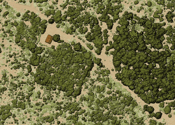
Рис. 28.15 Thining point cloud (by sampling radius)
См.также
Параметры
Basic parameters
Ярлык |
Имя |
Тип |
Описание |
|---|---|---|---|
Исходный слой |
|
[point cloud] |
Input point cloud layer to create a thinned version from |
Sampling radius (in map units) |
|
[number] Default: 1.0 |
Distance within which points are sampled to a unique point |
Thinned (by radius) |
|
[point cloud] По умолчанию: |
Specify the output point cloud with reduced points. One of:
|
Advanced parameters
Ярлык |
Имя |
Тип |
Описание |
|---|---|---|---|
Filter expression Optional |
|
[expression] |
A PDAL expression for selecting a subset of features in the point cloud data |
Cropping extent Optional |
|
[extent] |
A map extent for selecting a subset of features in the point cloud data Available methods are:
|
Результаты
Ярлык |
Имя |
Тип |
Описание |
|---|---|---|---|
Thinned (by radius) |
|
[point cloud] |
Output point cloud layer with reduced points. |
Код на Python
Algorithm ID: pdal:thinbyradius
import processing
processing.run("algorithm_id", {parameter_dictionary})
ID алгоритма отображается при наведении мыши на алгоритм в Инструментах анализа. Словарь parameter dictionary содержит ключи параметров и их значения. См. Изпользование алгоритмов геообработки в консоли для детального описания того, как запускать алгоритмы анализа из консоли Python.
28.1.13.9. Thin (by skipping points)
Creates a thinned version of the point cloud by keeping only every N-th point (reduces the number of points by skipping nearby points).
См.также
Параметры
Basic parameters
Ярлык |
Имя |
Тип |
Описание |
|---|---|---|---|
Исходный слой |
|
[point cloud] |
Input point cloud layer to create a thinned version from |
Number of points to skip |
|
[number] Default: 1 |
Keep only every N-th point in the input layer |
Thinned (by decimation) |
|
[point cloud] По умолчанию: |
Specify the output point cloud with reduced points. One of:
|
Advanced parameters
Ярлык |
Имя |
Тип |
Описание |
|---|---|---|---|
Filter expression Optional |
|
[expression] |
A PDAL expression for selecting a subset of features in the point cloud data |
Cropping extent Optional |
|
[extent] |
A map extent for selecting a subset of features in the point cloud data Available methods are:
|
Результаты
Ярлык |
Имя |
Тип |
Описание |
|---|---|---|---|
Thinned (by decimation) |
|
[point cloud] |
Output point cloud layer with reduced points. |
Код на Python
Algorithm ID: pdal:thinbydecimate
import processing
processing.run("algorithm_id", {parameter_dictionary})
ID алгоритма отображается при наведении мыши на алгоритм в Инструментах анализа. Словарь parameter dictionary содержит ключи параметров и их значения. См. Изпользование алгоритмов геообработки в консоли для детального описания того, как запускать алгоритмы анализа из консоли Python.
28.1.13.10. Tile
Creates tiles from input point cloud files, recommended for best performance (in display or analysis) with such datasets in QGIS.
См.также
Параметры
Basic parameters
Ярлык |
Имя |
Тип |
Описание |
|---|---|---|---|
Input layers |
|
[point cloud] [list] |
Input point cloud layers to create tiles from |
Tile length |
|
[number] Default: 1000.0 |
Size of the edge of each generated tile |
Output directory |
|
[folder] Default: |
Specify the folder to store the generated tiles. One of:
|
Advanced parameters
Ярлык |
Имя |
Тип |
Описание |
|---|---|---|---|
Assign CRS Optional |
|
[crs] |
The CRS to apply to the layer |
Результаты
Ярлык |
Имя |
Тип |
Описание |
|---|---|---|---|
Output directory |
|
[folder] |
Output folder containing the tiles generated from input files. |
Код на Python
Algorithm ID: pdal:tile
import processing
processing.run("algorithm_id", {parameter_dictionary})
ID алгоритма отображается при наведении мыши на алгоритм в Инструментах анализа. Словарь parameter dictionary содержит ключи параметров и их значения. См. Изпользование алгоритмов геообработки в консоли для детального описания того, как запускать алгоритмы анализа из консоли Python.