Важно
Перевод - это работа сообщества : ссылка:Вы можете присоединиться. Эта страница в настоящее время переводится |прогресс перевода|.
3. QGIS GUI
The QGIS graphical user interface (GUI) is shown in the figure below (the numbers 1 through 5 in yellow circles indicate important elements of the QGIS GUI, and are discussed below).
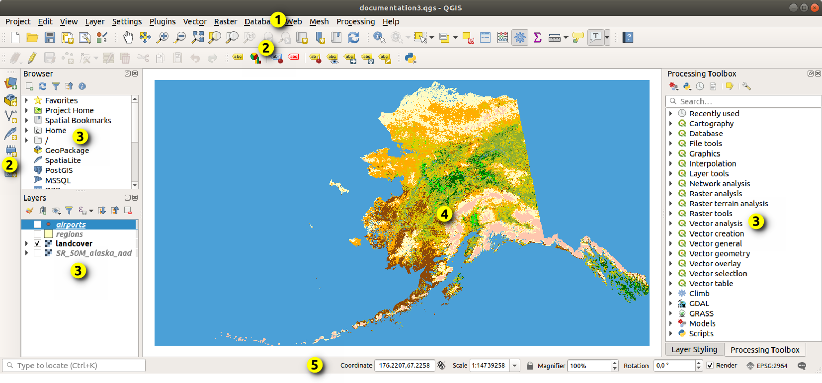
Рис. 3.1 QGIS GUI with Alaska sample data
Примечание
Внешний вид элементов интерфейса (заголовки окон и т.п.) может отличаться, в зависисмости от операционной системы и менеджера окон.
The main QGIS GUI (Рис. 3.1) consists of five components / component types:
Scroll down for detailed explanations of these.
3.1. Главное меню
The Menu bar provides access to QGIS functions using standard hierarchical menus. The Menus, their options, associated icons and keyboard shortcuts are described below. The keyboard shortcuts can be reconfigured ().
Most menu options have a corresponding tool and vice-versa. However, the Menus are not organized exactly like the toolbars. The locations of menu options in the toolbars are indicated below in the table. Plugins may add new options to Menus. For more information about tools and toolbars, see Панели инструментов.
Примечание
QGIS is a cross-platform application. Tools are generally available on all platforms, but they may be placed in different menus, depending on the operating systems. The lists below show the most common locations, including known variations.
3.1.1. Проект
The menu provides access and exit points for project files. It provides tools to:
Create a New project file from scratch or use another project file as a template (see Project files options for template configuration)
Open… a project from a file, a GeoPackage, PostgreSQL or Oracle database
Close a project or revert it to its last saved state
Save a project in
.qgsor.qgzfile format, either as a file or within a GeoPackage, PostgreSQL or Oracle databaseExport the map canvas to different formats or use a print layout for more complex output
Set project properties and snapping options for geometry editing.
Пункт меню |
Комбинация клавиш |
Панель инструментов |
Ссылки |
|---|---|---|---|
|
Ctrl+N |
Проект |
|
|
Ctrl+O |
Проект |
|
Alt+J + R |
|||
Close |
|||
|
Ctrl+S |
Проект |
|
|
Ctrl+Shift+S |
Проект |
|
Revert… |
|||
|
Ctrl+Shift+P |
||
Snapping Options… |
|||
|
|||
|
|||
|
Ctrl+P |
Проект |
|
|
|||
|
Проект |
||
|
Ctrl+Q |


Under  macOS, the Exit QGIS command corresponds to
(Cmd+Q).
macOS, the Exit QGIS command corresponds to
(Cmd+Q).
3.1.2. Правка
The menu provides most of the native tools needed
to edit layer attributes or geometry. To enable
menu options you need to switch to editing mode by clicking on  Toggle editing (see Редактирование for details).
Пункт меню |
Комбинация клавиш |
Панель инструментов |
Ссылки |
|---|---|---|---|
|
Ctrl+Z |
Оцифровка |
|
|
Ctrl+Shift+Z |
Оцифровка |
|
|
Ctrl+X |
Оцифровка |
|
|
Ctrl+C |
Оцифровка |
|
|
Ctrl+V |
Оцифровка |
|
Ctrl+Alt+V |
|||
|
Оцифровка |
||
|
Selection |
||
|
Selection |
||
|
Selection |
||
|
Selection |
||
|
F3 |
Selection |
|
|
Ctrl+F3 |
Selection |
|
|
Ctrl+Alt+A |
Selection |
|
|
Ctrl+Shift+A |
Selection |
|
|
Ctrl+A |
Selection |
|
|
Selection |
||
|
Ctrl+. |
Оцифровка |
|
|
Ctrl+. |
Оцифровка |
|
|
Ctrl+. |
Оцифровка |
|
|
Ctrl+. |
Оцифровка |
|
|
Annotations |
||
|
Annotations |
||
|
Оцифровка |
||
|
Advanced Digitizing |
||
|
Advanced Digitizing |
||
|
Advanced Digitizing |
||
|
Advanced Digitizing |
||
|
Advanced Digitizing |
||
|
Advanced Digitizing |
||
|
Advanced Digitizing |
||
|
Advanced Digitizing |
||
|
Advanced Digitizing |
||
|
Advanced Digitizing |
||
|
Advanced Digitizing |
||
|
Advanced Digitizing |
||
|
Advanced Digitizing |
||
|
Advanced Digitizing |
||
|
Advanced Digitizing |
||
|
Advanced Digitizing |
||
|
Оцифровка |
||
|
Оцифровка |
||
|
Advanced Digitizing |
||
|
Advanced Digitizing |
||
|
Advanced Digitizing |
||
|
Advanced Digitizing |


Tools that depend on the selected layer geometry type i.e. point, polyline or polygon, are activated accordingly:
Пункт меню |
Точка |
Полилиния |
Полигон |
|---|---|---|---|
Move Feature(s) |
|
|
|
Copy and Move Feature(s) |
|
|
|


3.1.3. Вид
The map is rendered in map views. You can interact with these views using the tools. For example, you can:
Create new 2D or 3D map views next to the main map canvas
Zoom or pan to any place
Query the attributes or geometry of the displayed features
Enhance the map view with preview modes, annotations or decorations
Access any panel or toolbar
The menu also allows you to reorganize the QGIS interface itself using actions like:
Toggle Full Screen Mode: covers the whole screen while hiding the title bar
Toggle Panel Visibility: shows or hides enabled panels - useful when digitizing features (for maximum canvas visibility) as well as for (projected/recorded) presentations using QGIS main canvas
Toggle Map Only: hides panels, toolbars, menus and status bar and only shows the map canvas. Combined with the full screen option, it makes your screen display only the map.
Пункт меню |
Комбинация клавиш |
Панель инструментов |
Ссылки |
|---|---|---|---|
|
Ctrl+M |
Map Navigation |
|
|
Ctrl+Alt+M |
Map Navigation |
|
|
Map Navigation |
||
|
Map Navigation |
||
|
Ctrl+Alt++ |
Map Navigation |
|
|
Ctrl+Alt+- |
Map Navigation |
|
|
Map Navigation |
||
|
|||
|
Ctrl+Shift+I |
Атрибуты |
|
Атрибуты |
|||
|
Ctrl+Shift+M |
Атрибуты |
|
|
Ctrl+Shift+J |
Атрибуты |
|
|
Атрибуты |
||
|
Атрибуты |
||
|
Атрибуты |
||
|
|||
|
Ctrl+Shift+F |
Map Navigation |
|
|
Ctrl+J |
Map Navigation |
|
|
Map Navigation |
||
|
Map Navigation |
||
|
Map Navigation |
||
|
Map Navigation |
||
Alt+V + D |
|||
|
|||
|
|||
|
|||
|
|||
|
|||
|
|||
|
|||
|
Атрибуты |
||
|
Ctrl+B |
Map Navigation |
|
|
Ctrl+Shift+B |
Map Navigation |
|
|
|||
|
F5 |
Map Navigation |
|
|
Ctrl+Shift+U |
||
|
Ctrl+Shift+H |
||
|
|||
|
|||
|
|||
Toggle Selected Layers Independently |
|||
|
|||
Toggle Full Screen Mode |
F11 |
||
Toggle Panel Visibility |
Ctrl+Tab |
||
Toggle Map Only |
Ctrl+Shift+Tab |


Under  Linux KDE, ,
and Toggle Full Screen Mode
are in the menu.
Linux KDE, ,
and Toggle Full Screen Mode
are in the menu.
3.1.4. Слой
The menu provides a large set of tools to create new data sources, add them to a project or save modifications to them. Using the same data sources, you can also:
Duplicate a layer to generate a copy where you can modify the name, style (symbology, labels, …), joins, … The copy uses the same data source as the original.
Copy and Paste layers or groups from one project to another as a new instance whose properties can be modified independently. As for Duplicate, the layers are still based on the same data source.
or Embed Layers and Groups… from another project, as read-only copies which you cannot modify (see Embedding layers from external projects)
The menu also contains tools to configure, copy or paste layer properties (style, scale, CRS…).
Пункт меню |
Комбинация клавиш |
Панель инструментов |
Ссылки |
|---|---|---|---|
|
Ctrl+L |
Data Source Manager |
|
|
Ctrl+Shift+N |
Data Source Manager |
|
|
Data Source Manager |
||
|
Data Source Manager |
||
|
Data Source Manager |
||
|
Data Source Manager |
||
|
Data Source Manager |
||
|
Data Source Manager |
||
|
Ctrl+Shift+V |
Manage Layers |
|
|
Ctrl+Shift+R |
Manage Layers |
|
|
Manage Layers |
||
|
Ctrl+Shift+T |
Manage Layers |
|
|
Ctrl+Shift+D |
Manage Layers |
|
|
Ctrl+Shift+L |
Manage Layers |
|
|
Manage Layers |
||
|
Manage Layers |
||
|
Manage Layers |
||
|
Manage Layers |
||
|
Ctrl+Shift+W |
Manage Layers |
|
|
|||
|
Manage Layers |
||
|
Manage Layers |
||
|
Manage Layers |
||
|
|||
|
|||
|
|||
Embed Layers and Groups… |
|||
Add from Layer Definition File… |
|||
|
|||
|
|||
|
|||
|
|||
|
|||
|
F6 |
Атрибуты |
|
|
Shift+F6 |
Атрибуты |
|
|
Ctrl+F6 |
Атрибуты |
|
|
Атрибуты |
||
|
Оцифровка |
||
|
Оцифровка |
||
|
Оцифровка |
||
Оцифровка |
|||
Оцифровка |
|||
Оцифровка |
|||
Оцифровка |
|||
Оцифровка |
|||
Оцифровка |
|||
Save As… |
|||
Save As Layer Definition File… |
|||
|
Ctrl+D |
||
|
|||
Set Scale Visibility of Layer(s) |
|||
Set CRS of Layer(s) |
Ctrl+Shift+C |
||
Set Project CRS from Layer |
|||
Layer Properties… |
|||
Filter… |
Ctrl+F |
||
|
|||
|
|||
|
|||
|


3.1.5. Установки
Пункт меню |
Ссылки |
|---|---|
|
|
|
|
|
|
|
|
|


Under Linux KDE, you’ll find more tools in the
menu such as ,
and Toggle Full Screen Mode.
3.1.6. Модули
Пункт меню |
Комбинация клавиш |
Панель инструментов |
Ссылки |
|---|---|---|---|
|
|||
|
Ctrl+Alt+P |
Plugins |


When starting QGIS for the first time not all core plugins are loaded.
3.1.7. Вектор
The Vector menu provides tools for analyzing, managing and manipulating vector datasets. By default, it is filled with a set of predefined Processing algorithms, grouped by sub-menus. This provides shortcuts for many common vector-based GIS tasks from core providers. If not all these sub-menus are available, enable the Processing plugin in .
Примечание
The list of tools and their menu can be modified/extended with any Processing algorithms (read Configuring the Processing Framework) or by some third-party plugins.
This is what the Vector menu looks like if all the core plugins are enabled.
Пункт меню |
Комбинация клавиш |
Панель инструментов |
Ссылки |
|---|---|---|---|
|
|||
|
Vector |
||
Alt+O + G |
|||
|
|||
|
|||
|
|||
|
|||
|
|||
|
|||
|
|||
|
|||
|
|||
Alt+O + E |
|||
|
|||
|
|||
|
|||
|
|||
|
|||
|
|||
|
|||
|
|||
|
|||
|
|||
|
|||
|
|||
Alt+O + A |
|||
|
|||
|
|||
|
|||
|
|||
|
|||
|
|||
|
|||
|
|||
Alt+O + D |
|||
|
|||
|
|||
|
|||
|
|||
|
|||
Alt+O + R |
|||
|
|||
|
|||
|
|||
|
|||
|
|||
|
|||
|
|||
|
|||
|
|||
|
|||
|
|||
|


3.1.8. Растр
The Raster menu provides tools for analyzing, managing and manipulating raster datasets. By default, it is filled with a set of predefined Processing algorithms, grouped by sub-menus. This provides shortcuts for many common raster-based GIS tasks from core providers. If not all these sub-menus are available, enable the Processing plugin in .
Примечание
The list of tools and their menu can be modified/extended with any Processing algorithms (read Configuring the Processing Framework) or by some third-party plugins.
This is what the Raster menu looks like if all the core plugins are enabled.
Пункт меню |
Комбинация клавиш |
Панель инструментов |
Ссылки |
|---|---|---|---|
|
|||
Align Rasters… |
|||
|
|||
|
|||
|
|||
|
|||
|
|||
|
|||
|
|||
|
|||
|
|||
|
|||
|
|||
|
|||
|
|||
|
|||
|
|||
|
|||
|
|||
|
|||
|
|||
|
|||
|
|||
|
|||
|
|||
|
|||
|
|||
|
|||
|
|||
|
|||
|
|||
|


3.1.9. Database
The menu provides tools for Database interaction. If no database-related plugins are enabled, there will be no Database menu. This is what the menu looks like if all the core plugins are enabled.
Пункт меню |
Комбинация клавиш |
Панель инструментов |
Ссылки |
|---|---|---|---|
Offline editing… |
Alt+D + O |
||
|
Database |
||
|
Database |
||
|
Database |
||
|
Database |


When starting QGIS for the first time not all core plugins are loaded.
3.1.10. Web
This is what the Web menu looks like if all the core plugins are enabled. If no web plugins are enabled, there will be no Web menu.
Пункт меню |
Комбинация клавиш |
Панель инструментов |
Ссылки |
|---|---|---|---|
Alt+W + M |
|||
|
Web |
||

When starting QGIS for the first time not all core plugins are loaded.
3.1.11. Сетка
The menu provides tools needed to manipulate mesh layers. Third-party plugins can add items to this menu.
Пункт меню |
Комбинация клавиш |
Панель инструментов |
Ссылки |
|---|---|---|---|
|
|||
|


3.1.12. Анализ
Пункт меню |
Комбинация клавиш |
Панель инструментов |
Ссылки |
|---|---|---|---|
|
Ctrl+Alt+T |
||
|
Ctrl+Alt+G |
||
|
Ctrl+Alt+H |
||
|
Ctrl+Alt+R |
||
|


When starting QGIS for the first time not all core plugins are loaded.
3.1.13. Справка
Пункт меню |
Комбинация клавиш |
Панель инструментов |
Ссылки |
|---|---|---|---|
|
F1 |
Справка |
|
API Documentation |
|||
Report an Issue |
|||
Need commercial support? |
|||
|
Ctrl+H |
||
|
|||
|
|||
|


3.1.14. QGIS
This menu is only available under macOS and contains some OS
related commands.
Пункт меню |
Комбинация клавиш |
Ссылки |
|---|---|---|
About QGIS |
||
Preferences |
Cmd+, |
|
Hide QGIS |
Cmd+H |
|
Show All |
||
Hide Others |
Shift+Cmd+H |
|
Quit QGIS |
Cmd+Q |
Preferences corresponds to , About QGIS corresponds to and Quit QGIS corresponds to for other platforms.
3.2. Panels and Toolbars
From the menu (or ),
you can switch QGIS widgets ()
and toolbars () on and off.
To (de)activate any of them, right-click the menu bar or toolbar and
choose the item you want.
Panels and toolbars can be moved and placed wherever you like within
the QGIS interface.
The list can also be extended with the activation of Core or
external plugins.
3.2.1. Панели инструментов
The toolbars provide access to most of the functions in the menus, plus additional tools for interacting with the map. Each toolbar item has pop-up help available. Hover your mouse over the item and a short description of the tool’s purpose will be displayed.
Available toolbars are:
Toolbar name |
Main Reference for tools |
|---|---|
Advanced Digitizing |
|
Annotations |
|
Атрибуты |
|
Data Source Manager |
|
Database |
|
Оцифровка |
|
GPS |
|
GRASS |
|
Справка |
|
Метки |
|
Manage Layers |
|
Map Navigation |
|
Mesh Digitizing |
|
Plugins |
|
Проект |
Working with Project Files, Laying out the maps, The Style Library |
Processing Algorithms |
|
Raster |
|
Selection |
|
Shape digitizing |
|
Snapping |
|
Vector |
|
Web |
Примечание
Third-party plugins can extend the default toolbar with their own tools or provide their own toolbar.
Совет
Восстановление панелей инструментов
If you have accidentally hidden a toolbar, you can get it
back using
(or ).
If, for some reason, a toolbar (or any other widget) totally
disappears from the interface, you’ll find tips to get it back at
restoring initial GUI.
3.2.2. Panels
QGIS provides many panels. Panels are special widgets that you can interact with (selecting options, checking boxes, filling values…) to perform more complex tasks.
Below is a list of the default panels provided by QGIS:
Panel name |
Комбинация клавиш |
Ссылки |
|---|---|---|
Advanced Digitizing |
Ctrl+4 |
|
Browser |
Ctrl+2 |
|
Browser (2) |
||
Debugging/Development Tools |
F12 |
|
Elevation Profile |
||
Geometry Validation |
||
GPS Information |
Ctrl+0 |
|
GRASS Tools |
||
Layer Order |
Ctrl+9 |
|
Layer Styling |
Ctrl+3 |
|
Layers |
Ctrl+1 |
|
Log Messages |
||
Overview |
Ctrl+8 |
|
Processing Toolbox |
||
Results Viewer |
||
Snapping and Digitizing Options |
||
Spatial Bookmark Manager |
Ctrl+7 |
|
Statistics |
Ctrl+6 |
|
Temporal Controller |
||
Tile Scale |
||
Undo/Redo |
Ctrl+5 |
|
Vertex Editor |
3.3. Строка состояния
The status bar provides you with general information about the map view and processed or available actions, and offers you tools to manage the map view.
3.3.1. Панель локатора
On the left side of the status bar, the locator bar, a quick search widget, helps you find and run any feature or options in QGIS:
Click in the text widget to activate the locator search bar or press Ctrl+K.
Type a text associated with the item you are looking for (name, tag, keyword, …). By default, results are returned for the enabled locator filters, but you can limit the search to a certain scope by prefixing your text with the locator filters prefix, ie. typing
l cadwill return only the layers whose name containscad.The filter can also be selected with a double-click in the menu that shows when accessing the locator widget.
Click on a result to execute the corresponding action, depending on the type of item.
Совет
Limit the lookup to particular field(s) of the active layer
By default, a search with the «active layer features» filter (f) runs
through the whole attribute table of the layer. You can limit the search to
a particular field using the @ prefix. E.g., f @name sal or
@name sal returns only the features whose «name» attribute contains „sal“.
Text autocompletion is active when writing and the suggestion can be applied
using Tab key.
A more advanced control on the queried fields is possible from the layer Fields tab. Read Fields Properties for details.
Searching is handled using threads, so that results always become available as quickly as possible, even if slow search filters are installed. They also appear as soon as they are encountered by a filter, which means that e.g. a file search filter will show results one by one as the file tree is scanned. This ensures that the UI is always responsive, even if a very slow search filter is present (e.g. one which uses an online service).
Примечание
The Nominatim locator tool may behave differently (no autocompletion search, delay of fetching results, …) with respect to the OpenStreetMap Nominatim usage policy.
Совет
Quick access to the locator’s configurations
Click on the  icon inside the locator widget on the status bar to
display the list of filters you can use and a Configure entry that
opens the Locator tab of the menu.
icon inside the locator widget on the status bar to
display the list of filters you can use and a Configure entry that
opens the Locator tab of the menu.
3.3.2. Reporting actions
In the area next to the locator bar, a summary of actions you’ve carried out will be shown when needed (such as selecting features in a layer, removing layer, pan distance and direction) or a long description of the tool you are hovering over (not available for all tools).
In case of lengthy operations, such as gathering of statistics in raster layers, executing Processing algorithms or rendering several layers in the map view, a progress bar is displayed in the status bar.
3.3.3. Control the map canvas
The ![]() Coordinate option shows the current
position of the mouse, following it while moving across the map view.
You can set the units (and precision) in the
tab.
Click on the small button at the left of the textbox to toggle between
the Coordinate option and the
Coordinate option shows the current
position of the mouse, following it while moving across the map view.
You can set the units (and precision) in the
tab.
Click on the small button at the left of the textbox to toggle between
the Coordinate option and the  Extents option
that displays the coordinates of the current bottom-left and top-right
corners of the map view in map units.
Extents option
that displays the coordinates of the current bottom-left and top-right
corners of the map view in map units.
Next to the coordinate display you will find the Scale display. It shows the scale of the map view. There is a scale selector, which allows you to choose between predefined and custom scales.
On the right side of the scale display, press the  button
to lock the scale to use the magnifier to zoom in or out.
The magnifier allows you to zoom in to a map without altering the map
scale, making it easier to tweak the positions of labels and symbols
accurately.
The magnification level is expressed as a percentage.
If the Magnifier has a level of 100%, then the current map
is not magnified, i.e. is rendered at accurate scale relative to the monitor’s resolution (DPI).
A default magnification value can be defined within
,
which is very useful for high-resolution screens to enlarge small
symbols. In addition, a setting in
controls whether QGIS respects each monitor’s physical DPI or uses the overall system logical DPI.
button
to lock the scale to use the magnifier to zoom in or out.
The magnifier allows you to zoom in to a map without altering the map
scale, making it easier to tweak the positions of labels and symbols
accurately.
The magnification level is expressed as a percentage.
If the Magnifier has a level of 100%, then the current map
is not magnified, i.e. is rendered at accurate scale relative to the monitor’s resolution (DPI).
A default magnification value can be defined within
,
which is very useful for high-resolution screens to enlarge small
symbols. In addition, a setting in
controls whether QGIS respects each monitor’s physical DPI or uses the overall system logical DPI.
To the right of the magnifier tool you can define a current clockwise rotation for your map view in degrees.
On the right side of the status bar, the  Render
checkbox can be used to temporarily suspend the map view rendering
(see section Controlling map rendering).
Render
checkbox can be used to temporarily suspend the map view rendering
(see section Controlling map rendering).
To the right of the Render function, you find the
 EPSG:code button showing the current project CRS.
Clicking on this opens the Project Properties dialog and lets you
reproject the map view or adjust any other project property.
EPSG:code button showing the current project CRS.
Clicking on this opens the Project Properties dialog and lets you
reproject the map view or adjust any other project property.
Совет
Calculating the Correct Scale of Your Map Canvas
When you start QGIS, the default CRS is WGS 84 (EPSG 4326) and
units are degrees. This means that QGIS will interpret any
coordinate in your layer as specified in degrees.
To get correct scale values, you can either manually change this
setting in the General tab under
(e.g. to meters), or you
can use the EPSG:code icon seen above.
In the latter case, the units are set to what the project projection
specifies (e.g., +units=us-ft).
Note that CRS choice on startup can be set in .
3.3.4. Messaging
The  Messages button next to it opens the
Log Messages Panel which has information on underlying
processes (QGIS startup, plugins loading, processing tools…)
Messages button next to it opens the
Log Messages Panel which has information on underlying
processes (QGIS startup, plugins loading, processing tools…)