Wichtig
Übersetzen ist eine Gemeinschaftsleistung Sie können mitmachen. Diese Seite ist aktuell zu 59.56% übersetzt.
28.1.23. Vector overlay
28.1.23.1. Zuschneiden
Clips a vector layer using the features of an additional polygon layer.
Only the parts of the features in the input layer that fall within the polygons of the overlay layer will be added to the resulting layer.
Warnung
Geometry modification only
This operation modifies only the features geometry. The attribute values of the features are not modified, although properties such as area or length of the features will be modified by the overlay operation. If such properties are stored as attributes, those attributes will have to be manually updated.
This algorithm uses spatial indexes on the providers, prepared geometries and apply a clipping operation if the geometry isn’t wholly contained by the mask geometry.
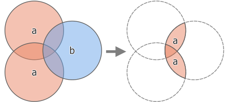
Abb. 28.119 Clipping operation between a two-feature input layer ‚a‘ and a single feature overlay layer ‚b‘ (left) - resulting in a new layer with the modified ‚a‘ features (right)
 Allows features in-place modification
of point, line, and polygon features
Allows features in-place modification
of point, line, and polygon features
Default menu:
Siehe auch
Parameter
Bezeichnung |
Name |
Typ |
Beschreibung |
|---|---|---|---|
Eingabe-Layer |
|
[Vektor: alle] |
Layer containing the features to be clipped |
Overlay layer |
|
[Vektor: Polygon] |
Layer containing the clipping features |
Zugeschnitten |
|
[wie input] Standard: |
Specify the layer to contain the features from the input layer that are inside the overlay (clipping) layer. One of:
Auch die Dateikodierung kann hier geändert werden. |
Ausgaben
Bezeichnung |
Name |
Typ |
Beschreibung |
|---|---|---|---|
Zugeschnitten |
|
[wie input] |
Layer containing features from the input layer split by the overlay layer. |
Pythoncode
Algorithm ID: qgis:clip
import processing
processing.run("algorithm_id", {parameter_dictionary})
Die Algorithmus-Kennung wird angezeigt, wenn Sie den Mauszeiger über den Algorithmus in der Verarbeitungs-Werkzeugkiste bewegen. Die Parameter-Liste (parameter_dictionary) enthält die Namen und Werte der Parameter. Siehe Verarbeitungs-Algorithmen von der Konsole aus verwenden für Details zur Ausführung von Verarbeitungsalgorithmen über die Python-Konsole.
28.1.23.2. Difference
Extracts features from the input layer that don’t fall within the boundaries of the overlay layer.
Input layer features that partially overlap the overlay layer feature(s) are split along the boundary of those feature(s) and only the portions outside the overlay layer features are retained.
Warnung
Geometry modification only
This operation modifies only the features geometry. The attribute values of the features are not modified, although properties such as area or length of the features will be modified by the overlay operation. If such properties are stored as attributes, those attributes will have to be manually updated.
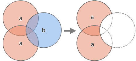
Abb. 28.120 Difference operation between a two-features input layer ‚a‘ and a single feature overlay layer ‚b‘ (left) - resulting in a new layer with the modified ‚a‘ features (right)
Allows features in-place modification
of point, line, and polygon features
Default menu:
Siehe auch
Parameter
Grundlegende Parameter
Bezeichnung |
Name |
Typ |
Beschreibung |
|---|---|---|---|
Eingabe-Layer |
|
[Vektor: alle] |
Layer to extract (parts of) features from. |
Overlay layer |
|
[Vektor: alle] |
Layer containing the geometries that will be subtracted from the input layer geometries. It is expected to have at least as many dimensions (point: 0D, line: 1D, polygon: 2D, volume: 3D) as the input layer geometries. |
Difference |
|
[wie input] Standard: |
Specify the layer to contain the (parts of) features from the input layer that are not inside the overlay layer. One of:
Auch die Dateikodierung kann hier geändert werden. |
Fortgeschrittene Parameter
Bezeichnung |
Name |
Typ |
Beschreibung |
|---|---|---|---|
Grid size Optional |
|
[Zahl] Default: Not set |
If provided, the input geometries are snapped to a grid of the given size, and the result vertices are computed on that same grid. Requires GEOS 3.9.0 or higher. |
Ausgaben
Bezeichnung |
Name |
Typ |
Beschreibung |
|---|---|---|---|
Difference |
|
[wie input] |
Layer containing (parts of) features from the input layer not overlapping the overlay layer. |
Pythoncode
Algorithm ID: qgis:difference
import processing
processing.run("algorithm_id", {parameter_dictionary})
Die Algorithmus-Kennung wird angezeigt, wenn Sie den Mauszeiger über den Algorithmus in der Verarbeitungs-Werkzeugkiste bewegen. Die Parameter-Liste (parameter_dictionary) enthält die Namen und Werte der Parameter. Siehe Verarbeitungs-Algorithmen von der Konsole aus verwenden für Details zur Ausführung von Verarbeitungsalgorithmen über die Python-Konsole.
28.1.23.3. Difference (multiple)
Extracts features from the input layer that fall completely outside or only partially overlap the features from any of the overlay layer(s).
For each overlay layer the difference is calculated between the result of all previous difference operations and this overlay layer. Input layer features that partially overlap feature(s) in the overlay layer are split along those features‘ boundary and only the portions outside the overlay layer features are retained.
Warnung
Geometry modification only
This operation modifies only the features geometry. The attribute values of the features are not modified, although properties such as area or length of the features will be modified by the overlay operation. If such properties are stored as attributes, those attributes will have to be manually updated.
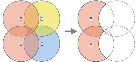
Abb. 28.121 Difference operation between a two-feature input layer ‚a‘ and single feature overlay layers ‚b‘ and ‚c‘ (left) - resulting in a new layer with the modified ‚a‘ features (right)
Siehe auch
Parameter
Bezeichnung |
Name |
Typ |
Beschreibung |
|---|---|---|---|
Eingabe-Layer |
|
[Vektor: alle] |
Layer to extract (parts of) features from. |
Overlay layers |
|
[vector: any] [list] |
List of layers containing the geometries that will be subtracted from the input layer geometries. They are expected to have at least as many dimensions (point: 0D, line: 1D, polygon: 2D, volume: 3D) as the input layer geometries. |
Difference |
|
[wie input] Standard: |
Specify the layer to contain the (parts of) features from the input layer that do not overlap features of the overlay layers. One of:
Auch die Dateikodierung kann hier geändert werden. |
Ausgaben
Bezeichnung |
Name |
Typ |
Beschreibung |
|---|---|---|---|
Difference |
|
[wie input] |
Layer containing (parts of) features from the input layer not overlapping features from the overlay layers. |
Pythoncode
Algorithm ID: qgis:multidifference
import processing
processing.run("algorithm_id", {parameter_dictionary})
Die Algorithmus-Kennung wird angezeigt, wenn Sie den Mauszeiger über den Algorithmus in der Verarbeitungs-Werkzeugkiste bewegen. Die Parameter-Liste (parameter_dictionary) enthält die Namen und Werte der Parameter. Siehe Verarbeitungs-Algorithmen von der Konsole aus verwenden für Details zur Ausführung von Verarbeitungsalgorithmen über die Python-Konsole.
28.1.23.4. Extract/clip by extent
Creates a new vector layer that only contains features which fall within a specified extent.
Any features which intersect the extent will be included.
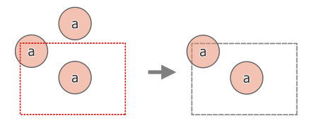
Abb. 28.122 Extract operation between a three-feature input layer ‚a‘ and a dashed extent (left) - resulting features with dashed extent for reference (right)
Siehe auch
Parameter
Bezeichnung |
Name |
Typ |
Beschreibung |
|---|---|---|---|
Eingabe-Layer |
|
[Vektor: alle] |
Layer to extract (parts of) features from. |
Extent (xmin, xmax, ymin, ymax) |
|
[Ausdehnung] |
Extent for clipping. Verfügbare Methoden sind:
|
Clip features to extent |
|
[Boolean] Standard: falsch |
If checked, output geometries will be automatically converted to multi geometries to ensure uniform output types. Moreover the geometries will be clipped to the extent chosen instead of taking the whole geometry as output. 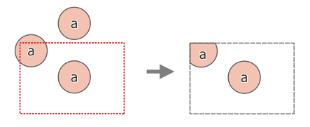
Abb. 28.123 Extract operation between a three-feature input layer ‚a‘ and a dashed extent (left) - resulting features with dashed extent for reference (right) |
Extracted |
|
[wie input] Standard: |
Specify the layer to contain the features from the input layer that are inside the clip extent. One of:
Auch die Dateikodierung kann hier geändert werden. |
Ausgaben
Bezeichnung |
Name |
Typ |
Beschreibung |
|---|---|---|---|
Extracted |
|
[wie input] |
Layer containing the clipped features. |
Pythoncode
Algorithm ID: qgis:extractbyextent
import processing
processing.run("algorithm_id", {parameter_dictionary})
Die Algorithmus-Kennung wird angezeigt, wenn Sie den Mauszeiger über den Algorithmus in der Verarbeitungs-Werkzeugkiste bewegen. Die Parameter-Liste (parameter_dictionary) enthält die Namen und Werte der Parameter. Siehe Verarbeitungs-Algorithmen von der Konsole aus verwenden für Details zur Ausführung von Verarbeitungsalgorithmen über die Python-Konsole.
28.1.23.5. Intersection
Extracts the portions of features from the input layer that overlap features in the overlay layer.
Features in the intersection layer are assigned the attributes of the overlapping features from both the input and overlay layers.
Warnung
Geometry modification only
This operation modifies only the features geometry. The attribute values of the features are not modified, although properties such as area or length of the features will be modified by the overlay operation. If such properties are stored as attributes, those attributes will have to be manually updated.
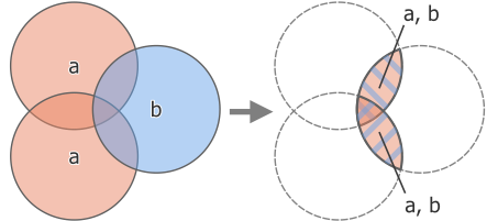
Abb. 28.124 Intersection operation between a two-feature input layer ‚a‘ and a single feature overlay layer ‚b‘ (left) - overlapping areas become a new two-feature layer with both layers‘ attributes (right)
Default menu:
Siehe auch
Parameter
Grundlegende Parameter
Bezeichnung |
Name |
Typ |
Beschreibung |
|---|---|---|---|
Eingabe-Layer |
|
[Vektor: alle] |
Layer to extract (parts of) features from. |
Overlay layer |
|
[Vektor: alle] |
Layer containing the features to check for overlap. Its features‘ geometry is expected to have at least as many dimensions (point: 0D, line: 1D, polygon: 2D, volume: 3D) as the input layer’s. |
Input fields to keep (leave empty to keep all fields) Optional |
|
[tablefield: any] [list] Default: None |
Field(s) of the input layer to keep in the output. If no fields are chosen all fields are taken. |
Overlay fields to keep (leave empty to keep all fields) Optional |
|
[tablefield: any] [list] Default: None |
Field(s) of the overlay layer to keep in the output. If no fields are chosen all fields are taken. Duplicate field names will be appended a count suffix to avoid collision. |
Intersection |
|
[wie input] Standard: |
Specify the layer to contain (the parts of) the features from the input layer that overlap one or more features from the overlay layer. One of:
Auch die Dateikodierung kann hier geändert werden. |
Fortgeschrittene Parameter
Bezeichnung |
Name |
Typ |
Beschreibung |
|---|---|---|---|
Overlay fields prefix Optional |
|
[string] |
Add a prefix to identify fields of the overlay layer. Duplicate field names will be appended a count suffix to avoid collision. |
Grid size Optional |
|
[Zahl] Default: Not set |
If provided, the input geometries are snapped to a grid of the given size, and the result vertices are computed on that same grid. Requires GEOS 3.9.0 or higher. |
Ausgaben
Bezeichnung |
Name |
Typ |
Beschreibung |
|---|---|---|---|
Intersection |
|
[wie input] |
Layer containing (parts of) features from the input layer that overlap the overlay layer. |
Pythoncode
Algorithm ID: qgis:intersection
import processing
processing.run("algorithm_id", {parameter_dictionary})
Die Algorithmus-Kennung wird angezeigt, wenn Sie den Mauszeiger über den Algorithmus in der Verarbeitungs-Werkzeugkiste bewegen. Die Parameter-Liste (parameter_dictionary) enthält die Namen und Werte der Parameter. Siehe Verarbeitungs-Algorithmen von der Konsole aus verwenden für Details zur Ausführung von Verarbeitungsalgorithmen über die Python-Konsole.
28.1.23.6. Intersection (multiple)
Extracts the overlapping portions of features in the input and all overlay layers.
Features in the output layer are assigned the attributes of the overlapping features from both the input and overlay layers.
Warnung
Geometry modification only
This operation modifies only the features geometry. The attribute values of the features are not modified, although properties such as area or length of the features will be modified by the overlay operation. If such properties are stored as attributes, those attributes will have to be manually updated.
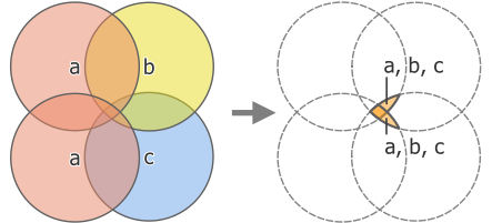
Abb. 28.125 Intersection operation between a two-feature input layer ‚a‘ and single feature overlay layers ‚b‘ and ‚c‘ (left) - overlapping areas become a new two-feature layer with all layers‘ attributes (right)
Siehe auch
Parameter
Grundlegende Parameter
Bezeichnung |
Name |
Typ |
Beschreibung |
|---|---|---|---|
Eingabe-Layer |
|
[Vektor: alle] |
Layer to extract (parts of) features from. |
Overlay layers |
|
[vector: any] [list] |
Layers containing the features to check for overlap. The features‘ geometry is expected to have at least as many dimensions (point: 0D, line: 1D, polygon: 2D, volume: 3D) as the input layer’s. |
Fortgeschrittene Parameter
Bezeichnung |
Name |
Typ |
Beschreibung |
|---|---|---|---|
Overlay fields prefix Optional |
|
[string] |
Add a prefix to identify fields of the overlay layers. Duplicate field names will be appended a count suffix to avoid collision. |
Ausgaben
Bezeichnung |
Name |
Typ |
Beschreibung |
|---|---|---|---|
Intersection |
|
[wie input] |
Layer containing (parts of) features from the input layer that overlap all the overlay layers. |
Pythoncode
Algorithm ID: qgis:multiintersection
import processing
processing.run("algorithm_id", {parameter_dictionary})
Die Algorithmus-Kennung wird angezeigt, wenn Sie den Mauszeiger über den Algorithmus in der Verarbeitungs-Werkzeugkiste bewegen. Die Parameter-Liste (parameter_dictionary) enthält die Namen und Werte der Parameter. Siehe Verarbeitungs-Algorithmen von der Konsole aus verwenden für Details zur Ausführung von Verarbeitungsalgorithmen über die Python-Konsole.
28.1.23.7. Line intersections
Creates point features where the lines from the two layers intersect.
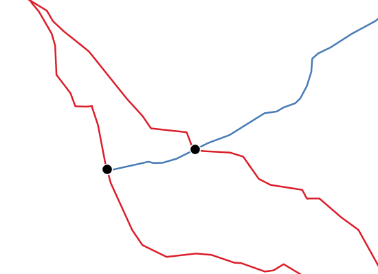
Abb. 28.126 Points of intersection
Default menu:
Parameter
Grundlegende Parameter
Bezeichnung |
Name |
Typ |
Beschreibung |
|---|---|---|---|
Eingabe-Layer |
|
[vector: line] |
Input line layer. |
Intersect layer |
|
[vector: line] |
Layer to use to find line intersections. |
Input fields to keep (leave empty to keep all fields) Optional |
|
[tablefield: any] [list] Default: None |
Field(s) of the input layer to keep in the output. If no fields are chosen all fields are taken. |
Intersect fields to keep (leave empty to keep all fields) Optional |
|
[tablefield: any] [list] Default: None |
Field(s) of the intersect layer to keep in the output. If no fields are chosen all fields are taken. Duplicate field names will be appended a count suffix to avoid collision. |
Intersection |
|
[vector: point] Standard: |
Specify the layer to contain the intersection points of the lines from the input and overlay layers. One of:
Auch die Dateikodierung kann hier geändert werden. |
Fortgeschrittene Parameter
Bezeichnung |
Name |
Typ |
Beschreibung |
|---|---|---|---|
Intersect fields prefix Optional |
|
[string] |
Add a prefix to identify fields of the intersect layer. |
Ausgaben
Bezeichnung |
Name |
Typ |
Beschreibung |
|---|---|---|---|
Intersections |
|
[vector: point] |
Point vector layer of the lines intersections, with both layers‘ attributes. |
Pythoncode
Algorithm ID: qgis:lineintersections
import processing
processing.run("algorithm_id", {parameter_dictionary})
Die Algorithmus-Kennung wird angezeigt, wenn Sie den Mauszeiger über den Algorithmus in der Verarbeitungs-Werkzeugkiste bewegen. Die Parameter-Liste (parameter_dictionary) enthält die Namen und Werte der Parameter. Siehe Verarbeitungs-Algorithmen von der Konsole aus verwenden für Details zur Ausführung von Verarbeitungsalgorithmen über die Python-Konsole.
28.1.23.8. Split with lines
Splits the lines or polygons in one layer using the lines or polygon rings in another layer to define the breaking points. Intersection between geometries in both layers are considered as split points.
Output will contain multi geometries for split features.
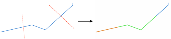
Abb. 28.127 Split lines
Allows features in-place modification
of line and polygon features
Parameter
Bezeichnung |
Name |
Typ |
Beschreibung |
|---|---|---|---|
Eingabe-Layer |
|
[vector: line, polygon] |
Layer containing the lines or polygons to split. |
Split layer |
|
[vector: line, polygon] |
Layer whose lines or rings are used to define the breaking points. |
Split |
|
[wie input] Standard: |
Specify the layer to contain the splitted (in case they are intersected by a line in the split layer) line/polygon features from the input layer. One of:
Auch die Dateikodierung kann hier geändert werden. |
Ausgaben
Bezeichnung |
Name |
Typ |
Beschreibung |
|---|---|---|---|
Split |
|
[wie input] |
Output vector layer with split lines or polygons from input layer. |
Pythoncode
Algorithm ID: qgis:splitwithlines
import processing
processing.run("algorithm_id", {parameter_dictionary})
Die Algorithmus-Kennung wird angezeigt, wenn Sie den Mauszeiger über den Algorithmus in der Verarbeitungs-Werkzeugkiste bewegen. Die Parameter-Liste (parameter_dictionary) enthält die Namen und Werte der Parameter. Siehe Verarbeitungs-Algorithmen von der Konsole aus verwenden für Details zur Ausführung von Verarbeitungsalgorithmen über die Python-Konsole.
28.1.23.9. Symmetrical difference
Creates a layer containing features from both the input and overlay layers but with the overlapping areas between the two layers removed.
The attribute table of the symmetrical difference layer contains attributes and fields from both the input and overlay layers.
Warnung
Geometry modification only
This operation modifies only the features geometry. The attribute values of the features are not modified, although properties such as area or length of the features will be modified by the overlay operation. If such properties are stored as attributes, those attributes will have to be manually updated.
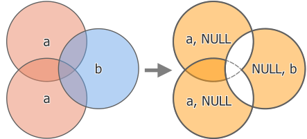
Abb. 28.128 Symmetrical difference operation between a two-features input layer ‚a‘ and a single feature overlay layer ‚b‘ (left) - resulting three-feature layer with both layers‘ attributes (right)
Default menu:
Siehe auch
Parameter
Grundlegende Parameter
Bezeichnung |
Name |
Typ |
Beschreibung |
|---|---|---|---|
Eingabe-Layer |
|
[Vektor: alle] |
First layer to extract (parts of) features from. |
Overlay layer |
|
[Vektor: alle] |
Second layer to extract (parts of) features from. Ideally the geometry type should be the same as input layer. |
Symmetrical difference |
|
[wie input] Standard: |
Specify the layer to contain (the parts of) the features from the input and overlay layers that do not overlap features from the other layer. One of:
Auch die Dateikodierung kann hier geändert werden. |
Fortgeschrittene Parameter
Bezeichnung |
Name |
Typ |
Beschreibung |
|---|---|---|---|
Overlay fields prefix Optional |
|
[string] |
Add a prefix to identify fields of the overlay layer. Duplicate field names will be appended a count suffix to avoid collision. |
Grid size Optional |
|
[Zahl] Default: Not set |
If provided, the input geometries are snapped to a grid of the given size, and the result vertices are computed on that same grid. Requires GEOS 3.9.0 or higher. |
Ausgaben
Bezeichnung |
Name |
Typ |
Beschreibung |
|---|---|---|---|
Symmetrical difference |
|
[wie input] |
Layer containing (parts of) features from each layer not overlapping the other layer, with both layers‘ attributes. |
Pythoncode
Algorithm ID: qgis:symmetricaldifference
import processing
processing.run("algorithm_id", {parameter_dictionary})
Die Algorithmus-Kennung wird angezeigt, wenn Sie den Mauszeiger über den Algorithmus in der Verarbeitungs-Werkzeugkiste bewegen. Die Parameter-Liste (parameter_dictionary) enthält die Namen und Werte der Parameter. Siehe Verarbeitungs-Algorithmen von der Konsole aus verwenden für Details zur Ausführung von Verarbeitungsalgorithmen über die Python-Konsole.
28.1.23.10. Union
Checks overlaps between features within the input layer and creates separate features for overlapping and non-overlapping parts. The area of overlap will create as many identical overlapping features as there are features that participate in that overlap.
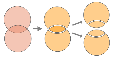
Abb. 28.129 Union operation with a single input layer with two overlapping features (left) - resulting in four features (middle) - features moved for clarity (right)
An overlay layer can also be used, in which case features from each layer are split at their overlap with features from the other one, creating a layer containing all the portions from both input and overlay layers. Features on the same layer will not split each other. The attribute table of the union layer is filled with attribute values from the respective original layer for non-overlapping features, and attribute values from both layers for overlapping features.
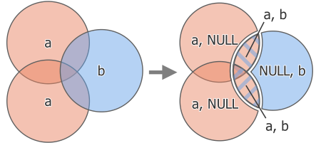
Abb. 28.130 Union operation between a two-feature input layer ‚a‘ and a single feature overlay layer ‚b‘ (left) - resulting five-feature layer with attributes from both layers (right)
Bemerkung
With an overlay layer, features on the same layer will not split each other. If you want to split overlaps on the same layer as well as other layers, first run the algorithm with multiple layers then run the algorithm again with only the previous output.
Default menu:
Siehe auch
Parameter
Grundlegende Parameter
Bezeichnung |
Name |
Typ |
Beschreibung |
|---|---|---|---|
Eingabe-Layer |
|
[Vektor: alle] |
Input vector layer to split at any intersections. |
Overlay layer Optional |
|
[Vektor: alle] |
Layer that will be combined to the first one. Ideally the geometry type should be the same as input layer. |
Union |
|
[wie input] Standard: |
Specify the layer to contain the (split and duplicated) features from the input layer and the overlay layer. One of:
Auch die Dateikodierung kann hier geändert werden. |
Fortgeschrittene Parameter
Bezeichnung |
Name |
Typ |
Beschreibung |
|---|---|---|---|
Overlay fields prefix Optional |
|
[string] |
Add a prefix to identify fields of the overlay layer. Duplicate field names will be appended a count suffix to avoid collision. |
Grid size Optional |
|
[Zahl] Default: Not set |
If provided, the input geometries are snapped to a grid of the given size, and the result vertices are computed on that same grid. Requires GEOS 3.9.0 or higher. |
Ausgaben
Bezeichnung |
Name |
Typ |
Beschreibung |
|---|---|---|---|
Union |
|
[wie input] |
Layer containing all the overlapping and non-overlapping parts from the processed layer(s). |
Pythoncode
Algorithm ID: qgis:union
import processing
processing.run("algorithm_id", {parameter_dictionary})
Die Algorithmus-Kennung wird angezeigt, wenn Sie den Mauszeiger über den Algorithmus in der Verarbeitungs-Werkzeugkiste bewegen. Die Parameter-Liste (parameter_dictionary) enthält die Namen und Werte der Parameter. Siehe Verarbeitungs-Algorithmen von der Konsole aus verwenden für Details zur Ausführung von Verarbeitungsalgorithmen über die Python-Konsole.
28.1.23.11. Union (multiple)
Checks overlaps between features within the input layer and creates separate features for overlapping and non-overlapping parts. The area of overlap will create as many identical overlapping features as there are features that participate in that overlap.
Abb. 28.131 Union operation with a single input layer with two overlapping features (left) - resulting in four features (middle) - features moved for clarity (right)
Multiple overlay layers can also be used, in which case features from each layer are split at their overlap with features from all other layers, creating a layer containing all the portions from both input and overlay layers. Features on the same layer will not split each other. The attribute table of the Union layer is filled with attribute values from the respective original layer for non-overlapping features, and attribute values from overlay layers for overlapping features.
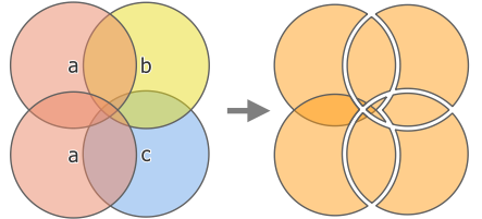
Abb. 28.132 Union operation between a two-feature input layer ‚a‘ and single feature overlay layers ‚b‘ and ‚c‘ (left) - resulting eleven-feature layer with attributes from all layers (right)
Bemerkung
With an overlay layer, features on the same layer will not split each other. If you want to split overlaps on the same layer as well as other layers, first run the algorithm with multiple layers then run the algorithm again with only the previous output.
Siehe auch
Parameter
Grundlegende Parameter
Bezeichnung |
Name |
Typ |
Beschreibung |
|---|---|---|---|
Eingabe-Layer |
|
[Vektor: alle] |
Input vector layer to split at any intersections. |
Overlay layers Optional |
|
[vector: any] [list] |
Layers that will be combined to the first one. Ideally the geometry type should be the same as input layer. |
Union |
|
[wie input] Standard: |
Specify the layer to contain the (split and duplicated) features from the input layer and the overlay layers. One of:
Auch die Dateikodierung kann hier geändert werden. |
Fortgeschrittene Parameter
Bezeichnung |
Name |
Typ |
Beschreibung |
|---|---|---|---|
Overlay fields prefix Optional |
|
[string] |
Add a prefix to identify fields of the overlay layers. Duplicate field names will be appended a count suffix to avoid collision. |
Ausgaben
Bezeichnung |
Name |
Typ |
Beschreibung |
|---|---|---|---|
Union |
|
[wie input] |
Layer containing all the overlapping and non-overlapping parts from the processed layer(s), with all layers‘ attributes. |
Pythoncode
Algorithm ID: qgis:multiunion
import processing
processing.run("algorithm_id", {parameter_dictionary})
Die Algorithmus-Kennung wird angezeigt, wenn Sie den Mauszeiger über den Algorithmus in der Verarbeitungs-Werkzeugkiste bewegen. Die Parameter-Liste (parameter_dictionary) enthält die Namen und Werte der Parameter. Siehe Verarbeitungs-Algorithmen von der Konsole aus verwenden für Details zur Ausführung von Verarbeitungsalgorithmen über die Python-Konsole.