24.1.19. Tabela de vetores
24.1.19.1. Adicionar campo de autoincremento
Adiciona um novo campo inteiro a uma camada vetorial, com um valor sequencial para cada feição.
Este campo pode ser usado como um ID exclusivo para as feições da camada. O novo atributo não é adicionado à camada de entrada, mas uma nova camada é gerada.
O valor inicial para a série incremental pode ser especificado. Opcionalmente, a série incremental pode ser baseada em campos de agrupamento e uma ordem de classificação para feições também pode ser especificada.
Parâmetros
Etiqueta |
Nome |
Tipo |
Descrição |
|---|---|---|---|
Camada de entrada |
|
[vector: any] |
The input vector layer. |
Field name |
|
[string] Padrão: ‘AUTO’ |
Name of the field with autoincremental values |
Start values at Opcional |
|
[number] Padrão: 0 |
Choose the initial number of the incremental count |
Group values by Opcional |
|
[tablefield: any] [list] |
Select grouping field(s): instead of a single count run for the whole layer, a separate count is processed for each value returned by the combination of these fields. |
Sort expression Opcional |
|
[expression] |
Use an expression to sort the features in the layer either globally or if set, based on group fields. |
Ordernar ascendente |
|
[boolean] Padrão: Verdadeiro |
When a |
Sort nulls first |
|
[boolean] Padrão: Falso |
When a |
Incremented |
|
[same as input] Default: |
Specify the output vector layer with the auto increment field. One of:
A codificação do arquivo também pode ser alterada aqui. |
Saídas
Etiqueta |
Nome |
Tipo |
Descrição |
|---|---|---|---|
Incremented |
|
[same as input] |
Vector layer with auto incremental field |
Python code
Algorithm ID: qgis:addautoincrementalfield
import processing
processing.run("algorithm_id", {parameter_dictionary})
The algorithm id is displayed when you hover over the algorithm in the Processing Toolbox. The parameter dictionary provides the parameter NAMEs and values. See Usando os algoritmos do processamento a partir do Terminal Python. for details on how to run processing algorithms from the Python console.
24.1.19.2. Adicionar um campo à tabela de atributos
Adds a new field to a vector layer.
The name and characteristics of the attribute are defined as parameters.
O novo atributo não é adicionado à camada de entrada, mas uma nova camada é gerada.
Parâmetros
Etiqueta |
Nome |
Tipo |
Descrição |
|---|---|---|---|
Camada de entrada |
|
[vector: any] |
A camada de entrada |
Field name |
|
[string] |
Name of the new field |
Field type |
|
[enumeration] Padrão: 0 |
Tipo do novo campo. Você pode escolher entre:
|
Field length |
|
[number] Padrão: 10 |
Length of the field |
Field precision |
|
[number] Padrão: 0 |
Precisão do campo. Usual com campo tipo flutuante. |
Added |
|
[same as input] Default: |
Especifique a camada vetorial de saída. Uma de:
A codificação do arquivo também pode ser alterada aqui. |
Saídas
Etiqueta |
Nome |
Tipo |
Descrição |
|---|---|---|---|
Added |
|
[same as input] |
Vector layer with new field added |
Python code
Algorithm ID: qgis:addfieldtoattributestable
import processing
processing.run("algorithm_id", {parameter_dictionary})
The algorithm id is displayed when you hover over the algorithm in the Processing Toolbox. The parameter dictionary provides the parameter NAMEs and values. See Usando os algoritmos do processamento a partir do Terminal Python. for details on how to run processing algorithms from the Python console.
24.1.19.3. Adicionar índice do campo valores únicos
Takes a vector layer and an attribute and adds a new numeric field.
Values in this field correspond to values in the specified attribute, so features with the same value for the attribute will have the same value in the new numeric field.
This creates a numeric equivalent of the specified attribute, which defines the same classes.
O novo atributo não é adicionado à camada de entrada, mas uma nova camada é gerada.
Parâmetros
Etiqueta |
Nome |
Tipo |
Descrição |
|---|---|---|---|
Camada de entrada |
|
[vector: any] |
A camada de entrada. |
Class field |
|
[tablefield: any] |
Features that have the same value for this field will get the same index. |
Output field name |
|
[string] Default: ‘NUM_FIELD’ |
Name of the new field containing the indexes. |
Layer with index field |
|
[vector: any] Default: |
Vector layer with the numeric field containing indexes. One of:
A codificação do arquivo também pode ser alterada aqui. |
Class summary |
|
[table] Default: |
Specify the table to contain the summary of the class field mapped to the corresponding unique value. One of:
A codificação do arquivo também pode ser alterada aqui. |
Saídas
Etiqueta |
Nome |
Tipo |
Descrição |
|---|---|---|---|
Layer with index field |
|
[same as input] |
Vector layer with the numeric field containing indexes. |
Class summary |
|
[table] Default: |
Table with summary of the class field mapped to the corresponding unique value. |
Python code
Algorithm ID: qgis:adduniquevalueindexfield
import processing
processing.run("algorithm_id", {parameter_dictionary})
The algorithm id is displayed when you hover over the algorithm in the Processing Toolbox. The parameter dictionary provides the parameter NAMEs and values. See Usando os algoritmos do processamento a partir do Terminal Python. for details on how to run processing algorithms from the Python console.
24.1.19.4. Add X/Y fields to layer
Adds X and Y (or latitude/longitude) fields to a point layer. The X/Y fields can be calculated in a different CRS to the layer (e.g. creating latitude/longitude fields for a layer in a projected CRS).
Parâmetros
Etiqueta |
Nome |
Tipo |
Descrição |
|---|---|---|---|
Camada de entrada |
|
[vector: point] |
A camada de entrada. |
Coordinate system |
|
[crs] Default: “EPSG:4326” |
Coordinate reference system to use for the generated x and y fields. |
Field prefix Opcional |
|
[string] |
Prefix to add to the new field names to avoid name collisions with fields in the input layer. |
Added fields |
|
[vector: point] Default: |
Especifique a camada da linha de saída. Um de:
A codificação do arquivo também pode ser alterada aqui. |
Saídas
Etiqueta |
Nome |
Tipo |
Descrição |
|---|---|---|---|
Added fields |
|
[vector: point] |
The output layer - identical to the input layer but with two
new double fields, |
Python code
Algorithm ID: qgis:addxyfieldstolayer
import processing
processing.run("algorithm_id", {parameter_dictionary})
The algorithm id is displayed when you hover over the algorithm in the Processing Toolbox. The parameter dictionary provides the parameter NAMEs and values. See Usando os algoritmos do processamento a partir do Terminal Python. for details on how to run processing algorithms from the Python console.
24.1.19.5. Calculadora de campo avançada Python
Adds a new attribute to a vector layer, with values resulting from applying an expression to each feature.
The expression is defined as a Python function.
Parâmetros
Etiqueta |
Nome |
Tipo |
Descrição |
|---|---|---|---|
Camada de entrada |
|
[vector: any] |
Camada vetorial de entrada |
Result field name |
|
[string] Default: ‘NewField’ |
Name of the new field |
Field type |
|
[enumeration] Padrão: 0 |
Type of the new field. One of:
|
Field length |
|
[number] Padrão: 10 |
Length of the field |
Field precision |
|
[number] Padrão: 3 |
Precisão do campo. Usual com campo tipo flutuante. |
Global expression Opcional |
|
[string] |
The code in the global expression section will be executed only once before the calculator starts iterating through all the features of the input layer. Therefore, this is the correct place to import necessary modules or to calculate variables that will be used in subsequent calculations. |
Formula |
|
[string] |
The Python formula to evaluate. Example: To calculate the area of an input polygon layer you can add: value = $geom.area()
|
Calculado |
|
[same as input] Default: |
Specify the vector layer with the new calculated field. One of:
A codificação do arquivo também pode ser alterada aqui. |
Saídas
Etiqueta |
Nome |
Tipo |
Descrição |
|---|---|---|---|
Calculado |
|
[same as input] |
Vector layer with the new calculated field |
Python code
Algorithm ID: qgis:advancedpythonfieldcalculator
import processing
processing.run("algorithm_id", {parameter_dictionary})
The algorithm id is displayed when you hover over the algorithm in the Processing Toolbox. The parameter dictionary provides the parameter NAMEs and values. See Usando os algoritmos do processamento a partir do Terminal Python. for details on how to run processing algorithms from the Python console.
24.1.19.6. Descartar campo(s)
Takes a vector layer and generates a new one that has the same features but without the selected columns.
Parâmetros
Etiqueta |
Nome |
Tipo |
Descrição |
|---|---|---|---|
Camada de entrada |
|
[vector: any] |
Input vector layer to drop field(s) from |
Fields to drop |
|
[tablefield: any] [list] |
The field(s) to drop |
Remaining fields |
|
[same as input] Default: |
Specify the output vector layer with the remaining fields. One of:
A codificação do arquivo também pode ser alterada aqui. |
Saídas
Etiqueta |
Nome |
Tipo |
Descrição |
|---|---|---|---|
Remaining fields |
|
[same as input] |
Vector layer with the remaining fields |
Python code
Algorithm ID: qgis:deletecolumn
import processing
processing.run("algorithm_id", {parameter_dictionary})
The algorithm id is displayed when you hover over the algorithm in the Processing Toolbox. The parameter dictionary provides the parameter NAMEs and values. See Usando os algoritmos do processamento a partir do Terminal Python. for details on how to run processing algorithms from the Python console.
24.1.19.7. Explode HStore Field
Creates a copy of the input layer and adds a new field for every unique key in the HStore field.
The expected field list is an optional comma separated list. If this list is specified, only these fields are added and the HStore field is updated. By default, all unique keys are added.
The PostgreSQL HStore
is a simple key-value store used in PostgreSQL and OGR (when reading
an
OSM file
with the other_tags field.
Parâmetros
Etiqueta |
Nome |
Tipo |
Descrição |
|---|---|---|---|
Camada de entrada |
|
[vector: any] |
Camada vetorial de entrada |
HStore field |
|
[tablefield: any] |
The field(s) to drop |
Expected list of fields separated by a comma Opcional |
|
[string] Padrão: ‘’ |
Comma-separated list of fields to extract. The HStore field will be updated by removing these keys. |
Exploded |
|
[same as input] Default: |
Especifique a camada vetorial de saída. Uma de:
A codificação do arquivo também pode ser alterada aqui. |
Saídas
Etiqueta |
Nome |
Tipo |
Descrição |
|---|---|---|---|
Exploded |
|
[same as input] |
Output vector layer |
Python code
Algorithm ID: qgis:explodehstorefield
import processing
processing.run("algorithm_id", {parameter_dictionary})
The algorithm id is displayed when you hover over the algorithm in the Processing Toolbox. The parameter dictionary provides the parameter NAMEs and values. See Usando os algoritmos do processamento a partir do Terminal Python. for details on how to run processing algorithms from the Python console.
24.1.19.8. Extract binary field
Extracts contents from a binary field, saving them to individual files. Filenames can be generated using values taken from an attribute in the source table or based on a more complex expression.
Parâmetros
Etiqueta |
Nome |
Tipo |
Descrição |
|---|---|---|---|
Camada de entrada |
|
[vector: any] |
Input vector layer containing the binary data |
Binary field |
|
[tablefield: any] |
Field containing the binary data |
File name |
|
[expression] |
Field or expression-based text to name each output file |
Destination folder |
|
[folder] Default: |
Folder in which to store the output files. One of:
A codificação do arquivo também pode ser alterada aqui. |
Saídas
Etiqueta |
Nome |
Tipo |
Descrição |
|---|---|---|---|
Folder |
|
[folder] |
The folder that contains the output files. |
Python code
Algorithm ID: qgis:extractbinary
import processing
processing.run("algorithm_id", {parameter_dictionary})
The algorithm id is displayed when you hover over the algorithm in the Processing Toolbox. The parameter dictionary provides the parameter NAMEs and values. See Usando os algoritmos do processamento a partir do Terminal Python. for details on how to run processing algorithms from the Python console.
24.1.19.9. Feature filter
Filters features from the input layer and redirects
them to one or several outputs.
If you do not know about any attribute names that are common to all
possible input layers, filtering is only possible on the feature
geometry and general record mechanisms, such as $id and uuid.
Nota
Este algoritmo só está disponível em Graphical modeler.
Parâmetros
Etiqueta |
Nome |
Tipo |
Descrição |
|---|---|---|---|
Camada de entrada |
|
[vector: any] |
A camada de entrada. |
Outputs and filters (one or more) |
|
[same as input] |
The output layers with filters (as many as there are filters). |
Saídas
Etiqueta |
Nome |
Tipo |
Descrição |
|---|---|---|---|
Saída (one or more) |
|
[same as input] |
The output layers with filtered features (as many as there are filters). |
Python code
Algorithm ID: qgis:featurefilter
import processing
processing.run("algorithm_id", {parameter_dictionary})
The algorithm id is displayed when you hover over the algorithm in the Processing Toolbox. The parameter dictionary provides the parameter NAMEs and values. See Usando os algoritmos do processamento a partir do Terminal Python. for details on how to run processing algorithms from the Python console.
24.1.19.10. Calculadora de campo
Opens the field calculator (see Expressões). You can use all the supported expressions and functions.
A new layer is created with the result of the expression.
The field calculator is very useful when used in O modelador gráfico.
Parâmetros
Etiqueta |
Nome |
Tipo |
Descrição |
|---|---|---|---|
Camada de entrada |
|
[vector: any] |
The layer to calculate on |
Output field name |
|
[string] |
The name of the field for the results |
Output field type |
|
[enumeration] Padrão: 0 |
The type of the field. One of:
|
Output field width |
|
[number] Padrão: 10 |
The length of the result field (minimum 0) |
Field precision |
|
[number] Padrão: 3 |
The precision of the result field (minimum 0, maximum 15) |
Create new field |
|
[boolean] Padrão: Verdadeiro |
Should the result field be a new field |
Formula |
|
[expression] |
The formula to use to calculate the result |
Output file |
|
[vector: any] Default: |
Specification of the output layer. |
Saídas
Etiqueta |
Nome |
Tipo |
Descrição |
|---|---|---|---|
Calculado |
|
[vector: any] |
Output layer with the calculated field values |
Python code
Algorithm ID: qgis:fieldcalculator
import processing
processing.run("algorithm_id", {parameter_dictionary})
The algorithm id is displayed when you hover over the algorithm in the Processing Toolbox. The parameter dictionary provides the parameter NAMEs and values. See Usando os algoritmos do processamento a partir do Terminal Python. for details on how to run processing algorithms from the Python console.
24.1.19.11. Editar campos
Allows editing the structure of the attribute table of a vector layer.
Fields can be modified in their type and name, using a fields mapping.
The original layer is not modified. A new layer is generated, which contains a modified attribute table, according to the provided fields mapping.
Refactor layer fields allows to:
Change field names and types
Add and remove fields
Reordenar campos
Calcular novos campos baseado nas expressões
Load field list from another layer
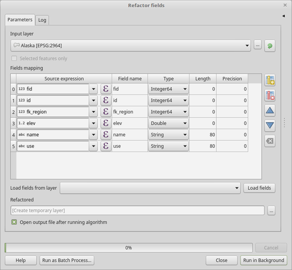
Fig. 24.102 Refactor fields dialog
Parâmetros
Etiqueta |
Nome |
Tipo |
Descrição |
|---|---|---|---|
Camada de entrada |
|
[vector: any] |
The layer to modify |
Fields mapping |
|
[list] |
List of output fields with their definitions. The embedded table lists all the fields of the source layer and allows you to edit them:
For each of the fields you’d like to reuse, you need to fill the following options:
Fields from another layer can be loaded into the field list in Load fields from layer. |
Refactored |
|
[vector: any] Default: |
Especificação da camada de saída. Uma de:
A codificação do arquivo também pode ser alterada aqui. |


Saídas
Etiqueta |
Nome |
Tipo |
Descrição |
|---|---|---|---|
Refactored |
|
[vector: any] |
Output layer with refactored fields |
Python code
Algorithm ID: qgis:refactorfields
import processing
processing.run("algorithm_id", {parameter_dictionary})
The algorithm id is displayed when you hover over the algorithm in the Processing Toolbox. The parameter dictionary provides the parameter NAMEs and values. See Usando os algoritmos do processamento a partir do Terminal Python. for details on how to run processing algorithms from the Python console.
24.1.19.12. Rename vector field
Renames an existing field from a vector layer.
The original layer is not modified. A new layer is generated where the attribute table contains the renamed field.
Ver também
Parâmetros
Etiqueta |
Nome |
Tipo |
Descrição |
|---|---|---|---|
Camada de entrada |
|
[vector: any] |
The input vector layer |
Field to rename |
|
[string] |
The field to be altered |
New field name |
|
[string] |
The new field name |
Renamed |
|
[vector: same as input] Default: |
Especificação da camada de saída. Uma de:
A codificação do arquivo também pode ser alterada aqui. |
Saídas
Etiqueta |
Nome |
Tipo |
Descrição |
|---|---|---|---|
Renamed |
|
[vector: same as input] |
Output layer with the renamed field |
Python code
Algorithm ID: qgis:renametablefield
import processing
processing.run("algorithm_id", {parameter_dictionary})
The algorithm id is displayed when you hover over the algorithm in the Processing Toolbox. The parameter dictionary provides the parameter NAMEs and values. See Usando os algoritmos do processamento a partir do Terminal Python. for details on how to run processing algorithms from the Python console.
24.1.19.13. Texto para flutuante
Modifies the type of a given attribute in a vector layer, converting a
text attribute containing numeric strings into a numeric attribute
(e.g. ‘1’ to 1.0).
The algorithm creates a new vector layer so the source one is not modified.
If the conversion is not possible the selected column will have
NULL values.
Parâmetros
Etiqueta |
Nome |
Tipo |
Descrição |
|---|---|---|---|
Camada de entrada |
|
[vector: any] |
The input vector layer. |
Text attribute to convert to float |
|
[tablefield: string] |
The string field for the input layer that is to be converted to a float field. |
Float from text |
|
[same as input] Default: |
Especifique a camada da linha de saída. Um de:
A codificação do arquivo também pode ser alterada aqui. |
Saídas
Etiqueta |
Nome |
Tipo |
Descrição |
|---|---|---|---|
Float from text |
|
[same as input] |
Output vector layer with the string field converted into a float field |
Python code
Algorithm ID: qgis:texttofloat
import processing
processing.run("algorithm_id", {parameter_dictionary})
The algorithm id is displayed when you hover over the algorithm in the Processing Toolbox. The parameter dictionary provides the parameter NAMEs and values. See Usando os algoritmos do processamento a partir do Terminal Python. for details on how to run processing algorithms from the Python console.