25.1.14. Raster tools
25.1.14.1. Convert map to raster
Creates a raster image of map canvas content.
A map theme can be selected to render a predetermined set of layers with a defined style for each layer.
Alternatively, a single layer can be selected if no map theme is set.
If neither map theme nor layer is set, the current map content will be rendered. The minimum extent entered will internally be extended to be a multiple of the tile size.
Parameter
Label |
Name |
Type |
Beschreibung |
|---|---|---|---|
Minimum extent to render (xmin, xmax, ymin, ymax) |
|
[extent] |
Specify the extent of the output raster layer. It will internally be extended to a multiple of the tile size. Available methods are:
|
Tile size |
|
[number] Default: 1024 |
Size of the tile of the output raster layer. Minimum value: 64. |
Map units per pixel |
|
[number] Default: 100.0 |
Pixel size (in map units). Minimum value: 0.0 |
Make background transparent |
|
[boolean] Default: False |
Allows exporting the map with a transparent background.
Outputs an RGBA (instead of RGB) image if set to |
Map theme to render Optional |
|
[enumeration] |
Use an existing map theme for the rendering. |
Single layer to render Optional |
|
[enumeration] |
Choose a single layer for the rendering |
Output layer |
|
[raster] Default: |
Specification of the output raster. One of:
|
Ausgaben
Label |
Name |
Type |
Beschreibung |
|---|---|---|---|
Output layer |
|
[raster] |
Output raster layer |
Python code
Algorithm ID: native:rasterize
import processing
processing.run("algorithm_id", {parameter_dictionary})
The algorithm id is displayed when you hover over the algorithm in the Processing Toolbox. The parameter dictionary provides the parameter NAMEs and values. See Verarbeitung Algorithmen von der Konsole aus verwenden for details on how to run processing algorithms from the Python console.
25.1.14.2. Fill NoData cells
Resets the NoData values in the input raster to a chosen value, resulting in raster dataset with no NoData pixels.
The algorithm respects the input raster data type, e.g. a floating point fill value will be truncated when applied to an integer raster.
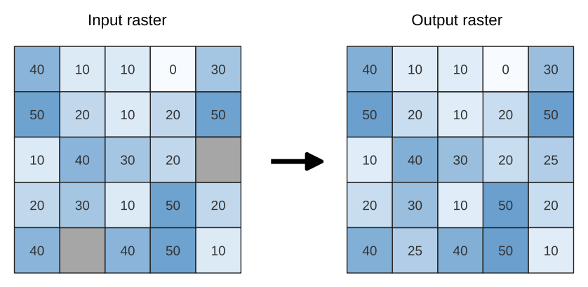
Abb. 25.30 Filling NoData values (in grey) of a raster
Parameter
Label |
Name |
Type |
Beschreibung |
|---|---|---|---|
Input raster |
|
[raster] |
The raster to process. |
Band number |
|
[number] Default: 1 |
The band of the raster |
Fill value |
|
[number] Default: 1.0 |
Set the value to use for the NoData pixels |
Output raster |
|
[raster] Default: |
Specification of the output raster. One of:
|
Ausgaben
Label |
Name |
Type |
Beschreibung |
|---|---|---|---|
Output raster |
|
[raster] |
The output raster layer with filled data cells. |
Python code
Algorithm ID: native:fillnodata
import processing
processing.run("algorithm_id", {parameter_dictionary})
The algorithm id is displayed when you hover over the algorithm in the Processing Toolbox. The parameter dictionary provides the parameter NAMEs and values. See Verarbeitung Algorithmen von der Konsole aus verwenden for details on how to run processing algorithms from the Python console.
25.1.14.3. Generate XYZ tiles (Directory)
Generates raster “XYZ” tiles using the current QGIS project as individual images to a directory structure.
Parameter
Label |
Name |
Type |
Beschreibung |
|---|---|---|---|
Extent (xmin, xmax, ymin, ymax) |
|
[extent] |
Specify the extent of the tiles. It will internally be extended to a multiple of the tile size. Available methods are:
|
Minimum zoom |
|
[number] Default: 12 |
Minimum 0, maximum 25. |
Maximum zoom |
|
[number] Default: 12 |
Minimum 0, maximum 25. |
DPI |
|
[number] Default: 96 |
Minimum 48, maximum 600. |
Background color Optional |
|
[color] Default: QColor(0, 0, 0, 0) |
Choose the background color for the tiles |
Tile format |
|
[enumeration] Default: 0 |
One of:
|
Quality (JPG only) Optional |
|
[number] Default: 75 |
Minimum 1, maximum 100. |
Metatile size Optional |
|
[number] Default: 4 |
Specify a custom metatile size when generating XYZ tiles. Larger values may speed up the rendering of tiles and provide better labelling (fewer gaps without labels) at the expense of using more memory. Minimum 1, maximum 20. |
Tile width Optional |
|
[number] Default: 256 |
Minimum 1, maximum 4096. |
Tile height Optional |
|
[number] Default: 256 |
Minimum 1, maximum 4096. |
Use inverted tile Y axis (TMS conventions) Optional |
|
[boolean] Default: False |
|
Output directory |
|
[folder] Default: |
Specification of the output raster. One of:
|
Output html (Leaflet) |
|
[html] Default: |
Specification of the output HTML file. One of:
|
Ausgaben
Label |
Name |
Type |
Beschreibung |
|---|---|---|---|
Output directory |
|
[folder] |
Output directory (for the tiles) |
Output html (Leaflet) |
|
[html] |
The output HTML (Leaflet) file |
Python code
Algorithm ID: qgis:tilesxyzdirectory
import processing
processing.run("algorithm_id", {parameter_dictionary})
The algorithm id is displayed when you hover over the algorithm in the Processing Toolbox. The parameter dictionary provides the parameter NAMEs and values. See Verarbeitung Algorithmen von der Konsole aus verwenden for details on how to run processing algorithms from the Python console.
25.1.14.4. Generate XYZ tiles (MBTiles)
Generates raster “XYZ” tiles using the current QGIS project as a single file in the “MBTiles” format.
Parameter
Label |
Name |
Type |
Beschreibung |
|---|---|---|---|
Extent (xmin, xmax, ymin, ymax) |
|
[extent] |
Specify the extent of the tiles. It will internally be extended to a multiple of the tile size. Available methods are:
|
Minimum zoom |
|
[number] Default: 12 |
Minimum 0, maximum 25. |
Maximum zoom |
|
[number] Default: 12 |
Minimum 0, maximum 25. |
DPI |
|
[number] Default: 96 |
Minimum 48, maximum 600. |
Background color Optional |
|
[color] Default: QColor(0, 0, 0, 0) |
Choose the background color for the tiles |
Tile format |
|
[enumeration] Default: 0 |
One of:
|
Quality (JPG only) Optional |
|
[number] Default: 75 |
Minimum 1, maximum 100. |
Metatile size Optional |
|
[number] Default: 4 |
Specify a custom metatile size when generating XYZ tiles. Larger values may speed up the rendering of tiles and provide better labelling (fewer gaps without labels) at the expense of using more memory. Minimum 1, maximum 20. |
Output file (for MBTiles) |
|
[file] Default: |
Specification of the output file. One of:
|
Ausgaben
Label |
Name |
Type |
Beschreibung |
|---|---|---|---|
Output file (for MBTiles) |
|
[file] |
The output file. |
Python code
Algorithm ID: qgis:tilesxyzmbtiles
import processing
processing.run("algorithm_id", {parameter_dictionary})
The algorithm id is displayed when you hover over the algorithm in the Processing Toolbox. The parameter dictionary provides the parameter NAMEs and values. See Verarbeitung Algorithmen von der Konsole aus verwenden for details on how to run processing algorithms from the Python console.