2.1. Lesson: Gambaran Umum Antarmuka
Kita akan mengeksplorasi antarmuka pengguna QGIS sehingga Anda akan terbiasa dengan menu, toolbar, kanvas peta dan daftar lapisan yang membentuk struktur dasar dari antarmuka.
Tujuan pelajaran ini: Memahami dasar dari antarmuka pengguna QGIS.
2.1.1.  Try Yourself: Dasar-Dasar
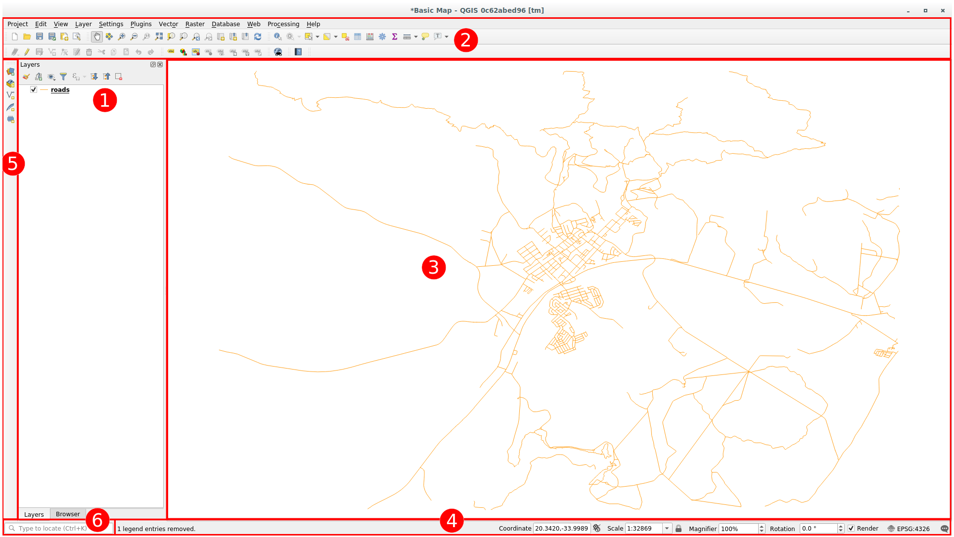
Unsur-unsur yang diidentifikasi dalam gambar di atas adalah:
Daftar Lapisan / Panel Penjelajah
Toolbar
Kanvas Peta
Bar Status
Toolbar Samping
Locator bar
Daftar Lapisan
Didalam daftar lapisan, Anda bisa melihat sebuah daftar, semua lapisan tersedia untuk Anda.
Memperluas item-item runtuh (dengan mengklik panah atau simbol plus di samping mereka) akan menyediakan Anda informasi lebih lanjut tentang penampilan lapisan saat ini.
Hovering over the layer will give you some basic information: layer name, type of geometry, coordinate reference system and the complete path of the location on your device.
Mengkilk-kanan pada lapisan akan memberikan Anda menu dengan opsi-opsi ekstra. Anda akan menggunakan beberapa diantaranya, jadi silakan melihatnya!
Catatan
Lapisan vektor adalah dataset, biasanya dari jenis tertentu dari obyek, seperti jalan, pohon, dll. Sebuah lapisan vektor dapat terdiri dari titik, garis atau poligon.
Panel Penjelajah
The QGIS Browser is a panel in QGIS that lets you easily navigate in your database. You can have access to common vector files (e.g. ESRI Shapefile or MapInfo files), databases (e.g. PostGIS, Oracle, SpatiaLite, GeoPackage or MSSQL Spatial) and WMS/WFS connections. You can also view your GRASS data.
If you have saved a project, the Browser Panel will also give you quick access to
all the layers stored in the same path of the project file under in the
 Project Home item.
Moreover, you can set one or more folder as Favorites: search under your path
and once you have found the folder, right click on it and click on Add as a
Favorite. You should then be able to see your folder in the  Favorites item.
Tip
It can happen that the folders added to Favorite item have a really
long name: don't worry right-click on the path and choose Rename Favorite...
to set another name.
Toolbar
Your most often used sets of tools can be turned into toolbars for basic access. For example, the File toolbar allows you to save, load, print, and start a new project. You can easily customize the interface to see only the tools you use most often, adding or removing toolbars as necessary via the menu.
Even if they are not visible in a toolbar, all of your tools will remain accessible via the menus. For example, if you remove the File toolbar (which contains the Save button), you can still save your map by clicking on the Project menu and then clicking on Save.
Kanvas Peta
Inilah tempat peta ditampilkan dan tempat lapisan dimuat. Pada kanvas peta, Anda dapat berinteraksi dengan lapisan yang terlihat: perbesar/perkecil, menggeser peta, memilih fitur dan banyak operasi lain yang kita akan lihat secara mendalam pada bagian berikutnya.
Bar Status
Shows you information about the current map. Also allows you to adjust the map scale, the map rotation and see the mouse cursor's coordinates on the map.
Toolbar Tepi
By default the Side toolbar contains the buttons to load the layer and all the buttons to create a new layer. But remember that you can move all the toolbars wherever it is more comfortable for you.
The Locator Bar
Within this bar you can access to almost all the objects of QGIS: layers, layer features, algorithms, spatial bookmarks, etc. Check all the different options in the Locator Settings section of the QGIS User Manual.
Tip
Dengan pintasan Ctrl+K Anda dapat secara mudah mengakses bar.
2.1.2. Try Yourself 1
Cobalah untuk mengidentifikasi empat unsur yang tercantum di atas pada layar Anda sendiri, tanpa mengacu pada diagram di atas. Lihat jika Anda dapat mengidentifikasi nama dan fungsi mereka. Anda akan menjadi lebih terbiasa dengan unsur-unsur seperti Anda menggunakannya dalam beberapa hari mendatang.
2.1.3. Try Yourself 2
Cobalah untuk menemukan masing-masing alat pada layar Anda. Apa tujuan mereka?


 Render
Catatan
Jika salah satu dari alat-alat ini tidak terlihat di layar, coba aktifkan beberapa toolbar yang saat ini tersembunyi. Juga perlu diingat bahwa jika tidak ada cukup ruang di layar, toolbar dapat dipersingkat dengan menyembunyikan beberapa alatnya. Anda dapat melihat alat yang tersembunyi dengan mengklik dobel tombol panah kanan dalam toolbar runtuh tersebut. Anda dapat melihat tooltip nama alat apapun dengan mengarahkan tetikus Anda ke alat untuk sementara waktu.
2.1.4. What's Next?
Now that you are familiar with the basics of the QGIS interface, in the next lesson we will see how to load some common data types.