Important
Traducerea este un efort al comunității, la care puteți să vă alăturați. În prezent, această pagină este tradusă 66.28%.
24.1.21. Raster tools
24.1.21.1. Align raster
Aligns raster by resampling it to the same cell size and reprojecting to the same CRS as a reference raster.
Atenționare
This algorithm is ONLY available in the Model Designer context. For other contexts, use instead Align rasters.
Parametri
Etichetă |
Nume |
Tipul |
Descriere |
|---|---|---|---|
Strat de intrare |
|
[raster] |
Input raster layer to align |
Resampling method |
|
[enumerare] Implicit: 0 |
Method to use for input layer resampling.
|
Rescale values according to the cell size |
|
[boolean] Implicit: Nu |
|
Reference layer |
|
[raster] |
A raster layer that will be used to fetch extent, cell size and CRS that will be applied to input layers. |
Override reference CRS Opţional |
|
[crs] |
CRS to be used instead of the reference layer’s |
Override reference cell size X Opţional |
|
[numeric: double] |
Cell size in X direction to be used instead of the reference layer’s |
Override reference cell size Y Opţional |
|
[numeric: double] |
Cell size in Y direction to be used instead of the reference layer’s |
Override reference grid offset X Opţional |
|
[numeric: double] |
Offset in X direction to apply to cells grid |
Override reference grid offset Y Opţional |
|
[numeric: double] |
Offset in Y direction to apply to cells grid |
Clip to extent Opţional |
|
[extent] |
Specify the extent of the output raster layer. It will internally be extended to a multiple of the tile size. Metodele disponibile sunt:
|
Aligned raster |
|
[raster] |
output raster with pixels resampled |
Rezultat
Etichetă |
Nume |
Tipul |
Descriere |
|---|---|---|---|
Aligned raster |
|
[raster] |
output raster with pixels resampled |
Cod Python
ID algoritm: native:alignsingleraster
import processing
processing.run("algorithm_id", {parameter_dictionary})
ID-ul algoritmului se afișează atunci când treceți peste algoritmul din caseta instrumentelor de procesare. Dicționarul parametrilor furnizează valorile și NUMELE parametrilor. Pentru detalii despre rularea algoritmilor de procesare din consola Python, parcurgeți Utilizarea algoritmilor de procesare din consolă.
24.1.21.2. Align rasters
Aligns rasters by resampling them to the same cell size and reprojecting to the same CRS as a reference raster.
Atenționare
This algorithm is NOT available in the Model Designer context. Use instead Align raster.
Parametri
Etichetă |
Nume |
Tipul |
Descriere |
|---|---|---|---|
Straturi de intrare |
|
[raster] [list] |
List of input raster layers with resampling options associated
(filled as a
Rescale values according to the cell size [boolean] ( |
Reference layer |
|
[raster] |
A raster layer that will be used to fetch extent, cell size and CRS that will be applied to input layers. |
Override reference CRS Opţional |
|
[crs] |
CRS to be used instead of the reference layer’s |
Override reference cell size X Opţional |
|
[numeric: double] |
Cell size in X direction to be used instead of the reference layer’s |
Override reference cell size Y Opţional |
|
[numeric: double] |
Cell size in Y direction to be used instead of the reference layer’s |
Override reference grid offset X Opţional |
|
[numeric: double] |
Offset in X direction to apply to cells grid |
Override reference grid offset Y Opţional |
|
[numeric: double] |
Offset in Y direction to apply to cells grid |
Clip to extent Opţional |
|
[extent] |
Specify the extent of the output raster layer. It will internally be extended to a multiple of the tile size. Metodele disponibile sunt:
|
Rezultat
Etichetă |
Nume |
Tipul |
Descriere |
|---|---|---|---|
Aligned rasters |
|
[raster] [list] |
output rasters with pixels resampled |
Cod Python
ID algoritm: native:alignrasters
import processing
processing.run("algorithm_id", {parameter_dictionary})
ID-ul algoritmului se afișează atunci când treceți peste algoritmul din caseta instrumentelor de procesare. Dicționarul parametrilor furnizează valorile și NUMELE parametrilor. Pentru detalii despre rularea algoritmilor de procesare din consola Python, parcurgeți Utilizarea algoritmilor de procesare din consolă.
24.1.21.3. Convert map to raster
Creates a raster image of map canvas content.
A map theme can be selected to render a predetermined set of layers with a defined style for each layer.
Alternatively, a single layer can be selected if no map theme is set.
If neither map theme nor layer is set, the current map content will be rendered. The minimum extent entered will internally be extended to be a multiple of the tile size.
Parametri
Etichetă |
Nume |
Tipul |
Descriere |
|---|---|---|---|
Minimum extent to render (xmin, xmax, ymin, ymax) |
|
[extent] |
Specify the extent of the output raster layer. It will internally be extended to a multiple of the tile size. Metodele disponibile sunt:
|
Tile size |
|
[numeric: integer] Implicit: 1024 |
Size of the tile of the output raster layer. Minimum value: 64. |
Map units per pixel |
|
[numeric: double] Implicit: 100.0 |
Pixel size (in map units). Minimum value: 0.0 |
Make background transparent |
|
[boolean] Implicit: False |
Allows exporting the map with a transparent background.
Outputs an RGBA (instead of RGB) image if set to |
Map theme to render Opţional |
|
[enumerare] |
Use an existing map theme for the rendering. |
Single layer to render Opţional |
|
[enumerare] |
Choose a single layer for the rendering |
Output layer |
|
[raster] Implicit: |
Specification of the output raster. One of:
|
Rezultat
Etichetă |
Nume |
Tipul |
Descriere |
|---|---|---|---|
Output layer |
|
[raster] |
Stratul raster de ieșire |
Cod Python
ID algoritm: native:rasterize
import processing
processing.run("algorithm_id", {parameter_dictionary})
ID-ul algoritmului se afișează atunci când treceți peste algoritmul din caseta instrumentelor de procesare. Dicționarul parametrilor furnizează valorile și NUMELE parametrilor. Pentru detalii despre rularea algoritmilor de procesare din consola Python, parcurgeți Utilizarea algoritmilor de procesare din consolă.
24.1.21.4. Umplere celule NoData
Resets the NoData values in the input raster to a chosen value, resulting in raster dataset with no NoData pixels.
The algorithm respects the input raster data type, e.g. a floating point fill value will be truncated when applied to an integer raster.
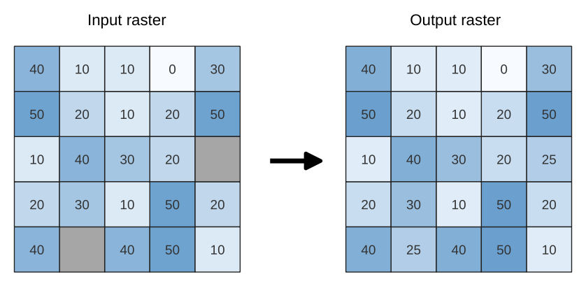
Fig. 24.80 Filling NoData values (in grey) of a raster
Parametri
Parametri de bază
Etichetă |
Nume |
Tipul |
Descriere |
|---|---|---|---|
Input raster |
|
[raster] |
The raster to process. |
Numărul benzii |
|
[raster band] Implicit: 1 |
The band of the raster |
Fill value |
|
[numeric: double] Implicit: 1.0 |
Set the value to use for the NoData pixels |
Raster de ieșire |
|
[raster] Implicit: |
Specification of the output raster. One of:
|
Parametri avansați
Etichetă |
Nume |
Tipul |
Descriere |
|---|---|---|---|
Creation options Opţional
|
|
[șir] Implicit: „ |
Pentru adăugarea uneia sau mai multor opțiuni de control la crearea rasterului (ex.: culori, dimensiunea blocului, compresia fișierului…). Pentru ușurință, vă puteți baza pe profiluri predefinite (consultați Secțiunea opțiunilor driver-ului GDAL). Procesarea în Serie și Designerul de Modele: separați opțiunile multiple cu un caracter pipe ( |
Rezultat
Etichetă |
Nume |
Tipul |
Descriere |
|---|---|---|---|
Raster de ieșire |
|
[raster] |
The output raster layer with filled data cells. |
Cod Python
ID Algorithm: nativ:fillnodata
import processing
processing.run("algorithm_id", {parameter_dictionary})
ID-ul algoritmului se afișează atunci când treceți peste algoritmul din caseta instrumentelor de procesare. Dicționarul parametrilor furnizează valorile și NUMELE parametrilor. Pentru detalii despre rularea algoritmilor de procesare din consola Python, parcurgeți Utilizarea algoritmilor de procesare din consolă.
24.1.21.5. Generate XYZ tiles (Directory)
Generates raster “XYZ” tiles using the current QGIS project as individual images to a directory structure.
Optionally, a Leaflet HTML output file using the generated tiles as a map layer could be created.
Parametri
Parametri de bază
Etichetă |
Nume |
Tipul |
Descriere |
|---|---|---|---|
Extent (xmin, xmax, ymin, ymax) |
|
[extent] |
Specify the extent of the tiles. It will internally be extended to a multiple of the tile size. Metodele disponibile sunt:
|
Minimum zoom |
|
[numeric: integer] Implicit: 12 |
Minimum 0, maximum 25. |
Maximum zoom |
|
[numeric: integer] Implicit: 12 |
Minimum 0, maximum 25. |
DPI |
|
[numeric: integer] Implicit: 96 |
Minimum 48, maximum 600. |
Background color Opţional |
|
[color] Implicit: QColor(0, 0, 0, 0) |
Choose the background color for the tiles |
Enable antialiasing |
|
[boolean] Implicit: True |
Determines if antialiasing should be enabled |
Tile format |
|
[enumerare] Implicit: 0 |
One of:
|
Quality (JPG only) Opţional |
|
[numeric: integer] Implicit: 75 |
Minimum 1, maximum 100. |
Metatile size Opţional |
|
[numeric: integer] Implicit: 4 |
Specify a custom metatile size when generating XYZ tiles. Larger values may speed up the rendering of tiles and provide better labelling (fewer gaps without labels) at the expense of using more memory. Minimum 1, maximum 20. |
Tile width Opţional |
|
[numeric: integer] Implicit: 256 |
Minimum 1, maximum 4096. |
Tile height Opţional |
|
[numeric: integer] Implicit: 256 |
Minimum 1, maximum 4096. |
Use inverted tile Y axis (TMS conventions) |
|
[boolean] Implicit: False |
|
Director de ieșire |
|
[folder] Implicit: |
Specification of the output directory (for the tiles). One of:
|
Output html (Leaflet) Opţional |
|
[html] Implicit: |
Specification of the output HTML file. One of:
|
Parametri avansați
Etichetă |
Nume |
Tipul |
Descriere |
|---|---|---|---|
Leaflet HTML output title Opţional
|
|
[șir] Implicit: Nesetat |
HTML <title>-tag used for the Leaflet HTML output file. |
Leaflet HTML output attribution Opţional
|
|
[șir] Implicit: Nesetat |
Custom map attribution used for the Leaflet HTML output file. HTML links are possible. |
Include OpenStreetMap basemap in Leaflet HTML output
|
|
[boolean] Implicit: False |
An OpenStreetMap basemap layer (source: https://tile.openstreetmap.org) is included in the Leaflet HTML output file. Proper map attribution is added automatically. |
Rezultat
Etichetă |
Nume |
Tipul |
Descriere |
|---|---|---|---|
Director de ieșire |
|
[folder] |
Output directory (for the tiles) |
Output html (Leaflet) |
|
[html] |
The output HTML (Leaflet) file |
Cod Python
ID algoritm: native:tilesxyzdirectory
import processing
processing.run("algorithm_id", {parameter_dictionary})
ID-ul algoritmului se afișează atunci când treceți peste algoritmul din caseta instrumentelor de procesare. Dicționarul parametrilor furnizează valorile și NUMELE parametrilor. Pentru detalii despre rularea algoritmilor de procesare din consola Python, parcurgeți Utilizarea algoritmilor de procesare din consolă.
24.1.21.6. Generate XYZ tiles (MBTiles)
Generates raster “XYZ” tiles using the current QGIS project as a single file in the “MBTiles” format.
Parametri
Etichetă |
Nume |
Tipul |
Descriere |
|---|---|---|---|
Extent (xmin, xmax, ymin, ymax) |
|
[extent] |
Specify the extent of the tiles. It will internally be extended to a multiple of the tile size. Metodele disponibile sunt:
|
Minimum zoom |
|
[numeric: integer] Implicit: 12 |
Minimum 0, maximum 25. |
Maximum zoom |
|
[numeric: integer] Implicit: 12 |
Minimum 0, maximum 25. |
DPI |
|
[numeric: integer] Implicit: 96 |
Minimum 48, maximum 600. |
Background color Opţional |
|
[color] Implicit: QColor(0, 0, 0, 0) |
Choose the background color for the tiles |
Enable antialiasing |
|
[boolean] Implicit: True |
Determines if antialiasing should be enabled |
Tile format |
|
[enumerare] Implicit: 0 |
One of:
|
Quality (JPG only) Opţional |
|
[numeric: integer] Implicit: 75 |
Minimum 1, maximum 100. |
Metatile size Opţional |
|
[numeric: integer] Implicit: 4 |
Specify a custom metatile size when generating XYZ tiles. Larger values may speed up the rendering of tiles and provide better labelling (fewer gaps without labels) at the expense of using more memory. Minimum 1, maximum 20. |
Output file (for MBTiles) |
|
[file] Implicit: |
Specification of the output file. One of:
|
Rezultat
Etichetă |
Nume |
Tipul |
Descriere |
|---|---|---|---|
Output file (for MBTiles) |
|
[file] |
The output file. |
Cod Python
ID algoritm: native:tilesxyzmbtiles
import processing
processing.run("algorithm_id", {parameter_dictionary})
ID-ul algoritmului se afișează atunci când treceți peste algoritmul din caseta instrumentelor de procesare. Dicționarul parametrilor furnizează valorile și NUMELE parametrilor. Pentru detalii despre rularea algoritmilor de procesare din consola Python, parcurgeți Utilizarea algoritmilor de procesare din consolă.