중요
번역은 여러분이 참여할 수 있는 커뮤니티 활동입니다. 이 페이지는 현재 71.46% 에서 번역되고 있습니다.
28.1.13. Point Cloud Data Management
NEW in 3.32
28.1.13.1. 투영체 할당하기
Assigns a Coordinate Reference System to a point cloud layer, if it is missing or wrong. A new layer is created.
더 보기
파라미터
라벨 |
이름 |
유형 |
설명 |
|---|---|---|---|
Input layer |
|
[point cloud] |
Input point cloud layer to assign a CRS to |
Desired CRS |
|
[crs] |
The CRS to apply to the layer |
Output layer |
|
[point cloud] 기본값: |
Specify the point cloud file to use as output. One of:
|
산출물
라벨 |
이름 |
유형 |
설명 |
|---|---|---|---|
Converted |
|
[point cloud] |
Output point cloud layer with a new CRS.
Currently supported formats are |
파이썬 코드
Algorithm ID: pdal:assignprojection
import processing
processing.run("algorithm_id", {parameter_dictionary})
공간 처리 툴박스에 있는 알고리즘 위에 마우스를 가져가면 알고리즘 ID 를 표시합니다. 파라미터 목록(dictionary) 은 파라미터 이름 및 값을 제공합니다. 파이썬 콘솔에서 공간 처리 알고리즘을 어떻게 실행하는지 자세히 알고 싶다면 콘솔에서 공간 처리 알고리즘 사용 을 참조하세요.
28.1.13.2. Build virtual point cloud (VPC)
Creates a virtual point cloud (VPC) from input point cloud data.
If you leave the optional parameters unchecked, the VPC file will be built very quickly as the algorithm will only read metadata of input files. With any of the optional parameters set, the algorithm will read all points which can take some time.
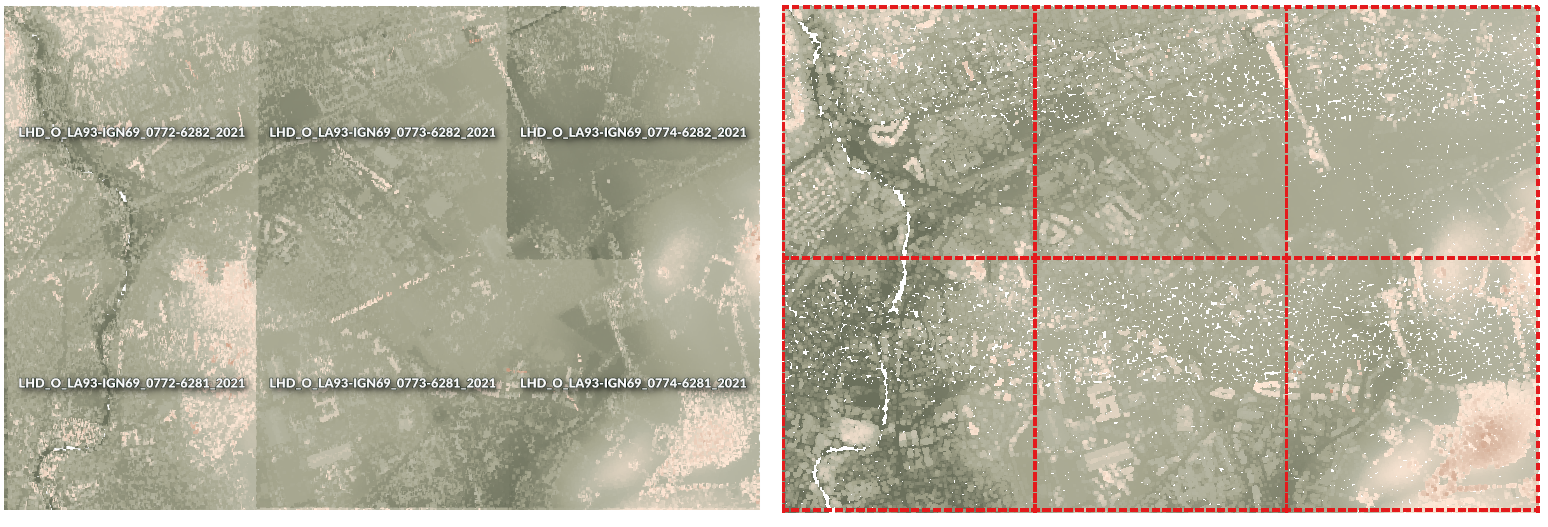
그림 28.13 Generating Virtual Point Cloud with overview from a set of point cloud tiles
더 보기
파라미터
라벨 |
이름 |
유형 |
설명 |
|---|---|---|---|
Input layers |
|
[point cloud] [list] |
Input point cloud layers to combine inside a virtual point cloud layer |
Calculate boundary polygon |
|
[boolean] 기본값: False |
Set to True to show the exact boundaries of data (rather than just rectangular extent) |
Calculate statistics |
|
[boolean] 기본값: False |
Set to True to understand ranges of values of the various attributes |
Build overview point cloud |
|
[boolean] 기본값: False |
Generates a single “thinned” point cloud of all the input data (using only every 1000th point from original data). The overview point cloud will be created next to the VPC file -
for example, for |
Virtual point cloud |
|
[point cloud] 기본값: |
Specify the point cloud file to build the data into. One of:
|
산출물
라벨 |
이름 |
유형 |
설명 |
|---|---|---|---|
Virtual point cloud |
|
[raster] |
Output point cloud layer combining all the input data, as a virtual file. |
파이썬 코드
Algorithm ID: pdal:virtualpointcloud
import processing
processing.run("algorithm_id", {parameter_dictionary})
공간 처리 툴박스에 있는 알고리즘 위에 마우스를 가져가면 알고리즘 ID 를 표시합니다. 파라미터 목록(dictionary) 은 파라미터 이름 및 값을 제공합니다. 파이썬 콘솔에서 공간 처리 알고리즘을 어떻게 실행하는지 자세히 알고 싶다면 콘솔에서 공간 처리 알고리즘 사용 을 참조하세요.
28.1.13.3. 잘라내기(Clip)
Clips a point cloud layer by a polygon layer so that the resulting point cloud contains only points within the polygons.
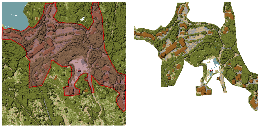
그림 28.14 Clipping an input point cloud layer with a polygon coverage
파라미터
기본 파라미터
라벨 |
이름 |
유형 |
설명 |
|---|---|---|---|
Input layer |
|
[point cloud] |
Input point cloud layer to clip |
Clipping polygons |
|
[vector: polygon] |
Polygon vector layer to use as coverage for clipping the points |
Clipped |
|
[point cloud] 기본값: |
Specify the point cloud file to export the clipped points to. One of:
|
고급 파라미터
라벨 |
이름 |
유형 |
설명 |
|---|---|---|---|
Filter expression 부가적 |
|
[expression] |
A PDAL expression for selecting a subset of features in the point cloud data |
Cropping extent 부가적 |
|
[extent] |
A map extent for selecting a subset of features in the point cloud data 다음과 같은 메소드를 사용할 수 있습니다: |
산출물
라벨 |
이름 |
유형 |
설명 |
|---|---|---|---|
Clipped |
|
[raster] |
Output point cloud whose features are the points within the coverage polygon layer. |
파이썬 코드
Algorithm ID: pdal:clip
import processing
processing.run("algorithm_id", {parameter_dictionary})
공간 처리 툴박스에 있는 알고리즘 위에 마우스를 가져가면 알고리즘 ID 를 표시합니다. 파라미터 목록(dictionary) 은 파라미터 이름 및 값을 제공합니다. 파이썬 콘솔에서 공간 처리 알고리즘을 어떻게 실행하는지 자세히 알고 싶다면 콘솔에서 공간 처리 알고리즘 사용 을 참조하세요.
28.1.13.4. Create COPC
Creates the index for all the input point cloud files in a batch mode.
파라미터
라벨 |
이름 |
유형 |
설명 |
|---|---|---|---|
Input layers |
|
[point cloud] [list] |
Input point cloud layers to create an index for |
Output directory 부가적 |
|
[folder] 기본값: |
Specify the folder to create the new files in. One of:
|
산출물
라벨 |
이름 |
유형 |
설명 |
|---|---|---|---|
Output directory |
|
[folder] |
Output folder containing point cloud layers with accompanying COPC index files. |
파이썬 코드
Algorithm ID: pdal:createcopc
import processing
processing.run("algorithm_id", {parameter_dictionary})
공간 처리 툴박스에 있는 알고리즘 위에 마우스를 가져가면 알고리즘 ID 를 표시합니다. 파라미터 목록(dictionary) 은 파라미터 이름 및 값을 제공합니다. 파이썬 콘솔에서 공간 처리 알고리즘을 어떻게 실행하는지 자세히 알고 싶다면 콘솔에서 공간 처리 알고리즘 사용 을 참조하세요.
28.1.13.5. Information
Outputs basic metadata from an input point cloud file.
Example of output information:
LAS           1.4
point format  6
count         56736130
scale         0.001 0.001 0.001
offset        431749.999 5440919.999 968.898
extent        431250 5440420 424.266
              432249.999 5441419.999 1513.531
crs           ETRS89 / UTM zone 34N (N-E) (EPSG:3046)  (vertical CRS missing!)
units         horizontal=metre  vertical=unknown

Attributes:
- X floating 8
- Y floating 8
- Z floating 8
- Intensity unsigned 2
- ReturnNumber unsigned 1
- NumberOfReturns unsigned 1
- ScanDirectionFlag unsigned 1
- EdgeOfFlightLine unsigned 1
- Classification unsigned 1
- ScanAngleRank floating 4
- UserData unsigned 1
- PointSourceId unsigned 2
- GpsTime floating 8
- ScanChannel unsigned 1
- ClassFlags unsigned 1
파라미터
라벨 |
이름 |
유형 |
설명 |
|---|---|---|---|
Input layer |
|
[point cloud] |
Input point cloud layer to extract metadata information from |
Layer information |
|
[file] 기본값: |
Specify the file to store the metadata information. One of:
|
산출물
라벨 |
이름 |
유형 |
설명 |
|---|---|---|---|
Layer information |
|
[vector] |
|
파이썬 코드
Algorithm ID: pdal:info
import processing
processing.run("algorithm_id", {parameter_dictionary})
공간 처리 툴박스에 있는 알고리즘 위에 마우스를 가져가면 알고리즘 ID 를 표시합니다. 파라미터 목록(dictionary) 은 파라미터 이름 및 값을 제공합니다. 파이썬 콘솔에서 공간 처리 알고리즘을 어떻게 실행하는지 자세히 알고 싶다면 콘솔에서 공간 처리 알고리즘 사용 을 참조하세요.
28.1.13.6. 병합하기
Merges multiple point cloud files into a single one.
파라미터
기본 파라미터
라벨 |
이름 |
유형 |
설명 |
|---|---|---|---|
Input layers |
|
[point cloud] [list] |
Input point cloud layers to merge into a single one |
Merged |
|
[point cloud] 기본값: |
Specify the output point cloud merging input files. One of:
|
고급 파라미터
라벨 |
이름 |
유형 |
설명 |
|---|---|---|---|
Filter expression 부가적 |
|
[expression] |
A PDAL expression for selecting a subset of features in the point cloud data |
Cropping extent 부가적 |
|
[extent] |
A map extent for selecting a subset of features in the point cloud data 다음과 같은 메소드를 사용할 수 있습니다: |
산출물
라벨 |
이름 |
유형 |
설명 |
|---|---|---|---|
Merged |
|
[point cloud] |
Output point cloud layer merging all the input files. |
파이썬 코드
Algorithm ID: pdal:merge
import processing
processing.run("algorithm_id", {parameter_dictionary})
공간 처리 툴박스에 있는 알고리즘 위에 마우스를 가져가면 알고리즘 ID 를 표시합니다. 파라미터 목록(dictionary) 은 파라미터 이름 및 값을 제공합니다. 파이썬 콘솔에서 공간 처리 알고리즘을 어떻게 실행하는지 자세히 알고 싶다면 콘솔에서 공간 처리 알고리즘 사용 을 참조하세요.
28.1.13.7. Reproject
Reprojects a point cloud to a different Coordinate Reference System (CRS).
더 보기
파라미터
라벨 |
이름 |
유형 |
설명 |
|---|---|---|---|
Input layer |
|
[point cloud] |
Input point cloud layer to reproject to a different CRS |
Target CRS |
|
[crs] |
The CRS to apply to the layer |
Reprojected |
|
[point cloud] 기본값: |
Specify the reprojected point cloud file. One of:
|
고급 파라미터
라벨 |
이름 |
유형 |
설명 |
|---|---|---|---|
Coordinate operation 부가적 |
|
[datum] |
The datum transformation to use to reproject the data between the origin and target systems. |
산출물
라벨 |
이름 |
유형 |
설명 |
|---|---|---|---|
REPROJECTED |
|
[point cloud] |
Output point cloud layer in the target CRS. |
파이썬 코드
Algorithm ID: pdal:reproject
import processing
processing.run("algorithm_id", {parameter_dictionary})
공간 처리 툴박스에 있는 알고리즘 위에 마우스를 가져가면 알고리즘 ID 를 표시합니다. 파라미터 목록(dictionary) 은 파라미터 이름 및 값을 제공합니다. 파이썬 콘솔에서 공간 처리 알고리즘을 어떻게 실행하는지 자세히 알고 싶다면 콘솔에서 공간 처리 알고리즘 사용 을 참조하세요.
28.1.13.8. Thin (by sampling radius)
Creates a thinned version of the point cloud by performing sampling by distance point (reduces the number of points within a certain radius).
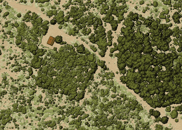
그림 28.15 Thining point cloud (by sampling radius)
파라미터
기본 파라미터
라벨 |
이름 |
유형 |
설명 |
|---|---|---|---|
Input layer |
|
[point cloud] |
Input point cloud layer to create a thinned version from |
Sampling radius (in map units) |
|
[number] 기본값: 1.0 |
Distance within which points are sampled to a unique point |
Thinned (by radius) |
|
[point cloud] 기본값: |
Specify the output point cloud with reduced points. One of:
|
고급 파라미터
라벨 |
이름 |
유형 |
설명 |
|---|---|---|---|
Filter expression 부가적 |
|
[expression] |
A PDAL expression for selecting a subset of features in the point cloud data |
Cropping extent 부가적 |
|
[extent] |
A map extent for selecting a subset of features in the point cloud data 다음과 같은 메소드를 사용할 수 있습니다: |
산출물
라벨 |
이름 |
유형 |
설명 |
|---|---|---|---|
Thinned (by radius) |
|
[point cloud] |
Output point cloud layer with reduced points. |
파이썬 코드
Algorithm ID: pdal:thinbyradius
import processing
processing.run("algorithm_id", {parameter_dictionary})
공간 처리 툴박스에 있는 알고리즘 위에 마우스를 가져가면 알고리즘 ID 를 표시합니다. 파라미터 목록(dictionary) 은 파라미터 이름 및 값을 제공합니다. 파이썬 콘솔에서 공간 처리 알고리즘을 어떻게 실행하는지 자세히 알고 싶다면 콘솔에서 공간 처리 알고리즘 사용 을 참조하세요.
28.1.13.9. Thin (by skipping points)
Creates a thinned version of the point cloud by keeping only every N-th point (reduces the number of points by skipping nearby points).
파라미터
기본 파라미터
라벨 |
이름 |
유형 |
설명 |
|---|---|---|---|
Input layer |
|
[point cloud] |
Input point cloud layer to create a thinned version from |
Number of points to skip |
|
[number] 기본값: 1 |
Keep only every N-th point in the input layer |
Thinned (by decimation) |
|
[point cloud] 기본값: |
Specify the output point cloud with reduced points. One of:
|
고급 파라미터
라벨 |
이름 |
유형 |
설명 |
|---|---|---|---|
Filter expression 부가적 |
|
[expression] |
A PDAL expression for selecting a subset of features in the point cloud data |
Cropping extent 부가적 |
|
[extent] |
A map extent for selecting a subset of features in the point cloud data 다음과 같은 메소드를 사용할 수 있습니다: |
산출물
라벨 |
이름 |
유형 |
설명 |
|---|---|---|---|
Thinned (by decimation) |
|
[point cloud] |
Output point cloud layer with reduced points. |
파이썬 코드
Algorithm ID: pdal:thinbydecimate
import processing
processing.run("algorithm_id", {parameter_dictionary})
공간 처리 툴박스에 있는 알고리즘 위에 마우스를 가져가면 알고리즘 ID 를 표시합니다. 파라미터 목록(dictionary) 은 파라미터 이름 및 값을 제공합니다. 파이썬 콘솔에서 공간 처리 알고리즘을 어떻게 실행하는지 자세히 알고 싶다면 콘솔에서 공간 처리 알고리즘 사용 을 참조하세요.
28.1.13.10. Tile
Creates tiles from input point cloud files, recommended for best performance (in display or analysis) with such datasets in QGIS.
파라미터
기본 파라미터
라벨 |
이름 |
유형 |
설명 |
|---|---|---|---|
Input layers |
|
[point cloud] [list] |
Input point cloud layers to create tiles from |
Tile length |
|
[number] Default: 1000.0 |
Size of the edge of each generated tile |
Output directory |
|
[folder] 기본값: |
Specify the folder to store the generated tiles. One of:
|
고급 파라미터
라벨 |
이름 |
유형 |
설명 |
|---|---|---|---|
Assign CRS 부가적 |
|
[crs] |
The CRS to apply to the layer |
산출물
라벨 |
이름 |
유형 |
설명 |
|---|---|---|---|
Output directory |
|
[folder] |
Output folder containing the tiles generated from input files. |
파이썬 코드
Algorithm ID: pdal:tile
import processing
processing.run("algorithm_id", {parameter_dictionary})
공간 처리 툴박스에 있는 알고리즘 위에 마우스를 가져가면 알고리즘 ID 를 표시합니다. 파라미터 목록(dictionary) 은 파라미터 이름 및 값을 제공합니다. 파이썬 콘솔에서 공간 처리 알고리즘을 어떻게 실행하는지 자세히 알고 싶다면 콘솔에서 공간 처리 알고리즘 사용 을 참조하세요.