重要
翻訳は あなたが参加できる コミュニティの取り組みです。このページは現在 49.41% 翻訳されています。
24.1.6. Fix Geometry
24.1.6.1. Add missing vertices along borders
Added in 3.42
Adds the missing vertices along polygons borders, based on an error layer from the Missing vertices along borders algorithm.
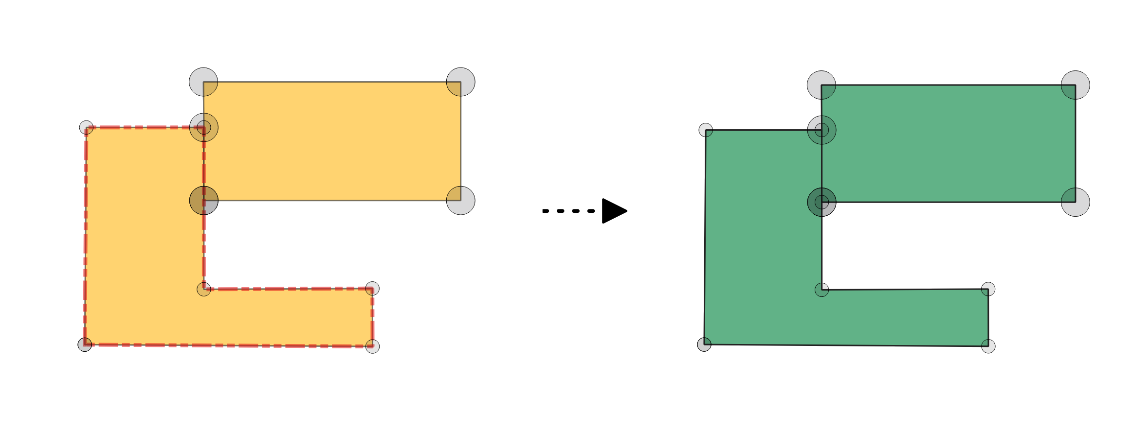
図 24.16 Fixing missing vertices along polygon borders.
パラメータ
基本パラメータ
ラベル |
名前 |
データ型 |
説明 |
|---|---|---|---|
入力レイヤ |
|
[ベクタ:ポリゴン] |
Layer with the geometries to fix, same as input in the check algorithm. |
Error layer |
|
[ベクタ:ポイント] |
Point layer with the errors location, generated by the check algorithm. |
Field of original feature unique identifier |
|
[テーブルのフィールド:任意] |
Field storing unique values for feature identification in input layer, as set in the check algorithm. |
Field of part index |
|
[tablefield: integer] Default: |
Field storing the erroneous feature's geometry part number. |
Field of ring index |
|
[tablefield: integer] Default: |
Field storing the erroneous feature's geometry ring number. |
Field of vertex index |
|
[tablefield: integer] Default: |
Field storing the erroneous feature's geometry vertex number. |
Border vertices fixed layer |
|
[ベクタ:ポリゴン] デフォルト: |
Specification of the output layer containing fixed features. One of:
ここでファイルの文字コードを変更することもできます。 |
Report layer from fixing border vertices |
|
[ベクタ:ポイント] デフォルト: |
Specification of the output layer containing the fixes location. One of:
ここでファイルの文字コードを変更することもできます。 |
詳細パラメータ
ラベル |
名前 |
データ型 |
説明 |
|---|---|---|---|
許容範囲 |
|
[数値: Integer] デフォルト: 8 |
Numerical precision of geometric operations, given as an integer n, meaning that two vertices less than 10-n apart (in map units) are considered to be merged. |
出力
ラベル |
名前 |
データ型 |
説明 |
|---|---|---|---|
Report layer from fixing border vertices |
|
[ベクタ:ポイント] |
Output point layer representing the error locations and fix applied. The output layer contains the following fields:
|
Border vertices fixed layer |
|
[ベクタ:ポリゴン] |
Output layer with the geometry fix applied to the input features. The layer contains the same fields as in the input layer. |
Python コード
Algorithm ID: native:fixgeometrymissingvertex
import processing
processing.run("algorithm_id", {parameter_dictionary})
algorithm id は、プロセシングツールボックス内でアルゴリズムにマウスカーソルを乗せた際に表示されるIDです。 parameter dictionary は、パラメータの「名前」とその値を指定するマッピング型です。Python コンソールからプロセシングアルゴリズムを実行する方法の詳細については、 プロセシングアルゴリズムをコンソールから使う を参照してください。
24.1.6.2. Convert to strictly multipart
Added in 3.42
Converts multipart geometries that consists of only one geometry into singlepart geometries, based on an error layer from the Strictly multipart algorithm. Layer geometry type will not be changed and will remain multipart.
参考
パラメータ
基本パラメータ
ラベル |
名前 |
データ型 |
説明 |
|---|---|---|---|
入力レイヤ |
|
[ベクタ:ライン、ポリゴン] |
Layer with the geometries to fix, same as input in the check algorithm. |
Error layer |
|
[ベクタ:ポイント] |
Point layer with the errors location, generated by the check algorithm. |
Field of original feature unique identifier |
|
[テーブルのフィールド:任意] |
Field storing unique values for feature identification in input layer, as set in the check algorithm. |
Strictly-multipart layer |
|
[ベクタ: 入力と同じ] デフォルト: |
Specification of the output layer containing fixed features. One of:
ここでファイルの文字コードを変更することもできます。 |
Report layer from fixing multipart |
|
[ベクタ:ポイント] デフォルト: |
Specification of the output layer containing the centroids of the fixed geometries. One of:
ここでファイルの文字コードを変更することもできます。 |
詳細パラメータ
ラベル |
名前 |
データ型 |
説明 |
|---|---|---|---|
許容範囲 |
|
[数値: Integer] デフォルト: 8 |
Numerical precision of geometric operations, given as an integer n, meaning that two vertices less than 10-n apart (in map units) are considered to be merged. |
出力
ラベル |
名前 |
データ型 |
説明 |
|---|---|---|---|
Report layer from fixing multipart |
|
[ベクタ:ポイント] |
Output point layer representing the error locations and fix applied. The output layer contains the following fields:
|
Strictly-multipart layer |
|
[ベクタ: 入力と同じ] |
Output layer with the geometry fix applied to the input features. The layer contains the same fields as in the input layer. |
Python コード
Algorithm ID: native:fixgeometrymultipart
import processing
processing.run("algorithm_id", {parameter_dictionary})
algorithm id は、プロセシングツールボックス内でアルゴリズムにマウスカーソルを乗せた際に表示されるIDです。 parameter dictionary は、パラメータの「名前」とその値を指定するマッピング型です。Python コンソールからプロセシングアルゴリズムを実行する方法の詳細については、 プロセシングアルゴリズムをコンソールから使う を参照してください。
24.1.6.3. Delete duplicated vertices
Added in 3.42
Deletes duplicated vertices from the input geometries, based on errors reported by the Duplicated vertices algorithm.
参考
パラメータ
基本パラメータ
ラベル |
名前 |
データ型 |
説明 |
|---|---|---|---|
入力レイヤ |
|
[ベクタ:ライン、ポリゴン] |
Layer with the geometries to fix, same as input in the check algorithm. |
Error layer |
|
[ベクタ:ポイント] |
Point layer with the errors location, generated by the check algorithm. |
Field of original feature unique identifier |
|
[テーブルのフィールド:任意] |
Field storing unique values for feature identification in input layer, as set in the check algorithm. |
Field of part index |
|
[tablefield: integer] Default: |
Field storing the erroneous feature's geometry part number. |
Field of ring index |
|
[tablefield: integer] Default: |
Field storing the erroneous feature's geometry ring number. |
Field of vertex index |
|
[tablefield: integer] Default: |
Field storing the erroneous feature's geometry vertex number. |
Fixed duplicate vertices layer |
|
[ベクタ: 入力と同じ] デフォルト: |
Specification of the output layer containing fixed features. One of:
ここでファイルの文字コードを変更することもできます。 |
Report layer from fixing duplicate vertices |
|
[ベクタ:ポイント] デフォルト: |
Specification of the output layer containing the fixes location. One of:
ここでファイルの文字コードを変更することもできます。 |
詳細パラメータ
ラベル |
名前 |
データ型 |
説明 |
|---|---|---|---|
許容範囲 |
|
[数値: Integer] デフォルト: 8 |
Numerical precision of geometric operations, given as an integer n, meaning that two vertices less than 10-n apart (in map units) are considered to be merged. |
出力
ラベル |
名前 |
データ型 |
説明 |
|---|---|---|---|
Report layer from fixing duplicate vertices |
|
[ベクタ:ポイント] |
Output point layer representing the error locations and fix applied. The output layer contains the following fields:
|
Fixed duplicate vertices layer |
|
[ベクタ: 入力と同じ] |
Output layer with the geometry fix applied to the input features. The layer contains the same fields as in the input layer. |
Python コード
Algorithm ID: native:fixgeometryduplicatenodes
import processing
processing.run("algorithm_id", {parameter_dictionary})
algorithm id は、プロセシングツールボックス内でアルゴリズムにマウスカーソルを乗せた際に表示されるIDです。 parameter dictionary は、パラメータの「名前」とその値を指定するマッピング型です。Python コンソールからプロセシングアルゴリズムを実行する方法の詳細については、 プロセシングアルゴリズムをコンソールから使う を参照してください。
24.1.6.4. 地物を削除する
Added in 3.42
Deletes error features based on an error layer from some check geometry algorithms, such as:
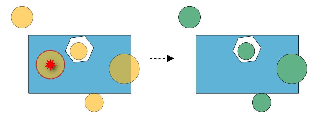
図 24.17 Fixing errors from the "Features inside polygon" algorithm check.
参考
パラメータ
基本パラメータ
ラベル |
名前 |
データ型 |
説明 |
|---|---|---|---|
入力レイヤ |
|
[vector: geometry] |
Layer with the geometries to fix, same as input in the check algorithm. |
Error layer |
|
[ベクタ:ポイント] |
Point layer with the errors location, generated by the check algorithm. |
Field of original feature unique identifier |
|
[テーブルのフィールド:任意] |
Field storing unique values for feature identification in input layer, as set in the check algorithm. |
Cleaned layer |
|
[ベクタ: 入力と同じ] デフォルト: |
Specification of the output layer containing fixed features. One of:
ここでファイルの文字コードを変更することもできます。 |
Report layer from deleting features |
|
[ベクタ:ポイント] デフォルト: |
Specification of the output layer containing the fixes location. One of:
ここでファイルの文字コードを変更することもできます。 |
出力
ラベル |
名前 |
データ型 |
説明 |
|---|---|---|---|
Report layer from deleting features |
|
[ベクタ:ポイント] |
Output point layer representing the error locations and fix applied. The output layer contains the following fields:
|
Cleaned layer |
|
[ベクタ: 入力と同じ] |
Output layer with features removed based on detected errors. The layer contains the same fields as in the input layer. |
Python コード
Algorithm ID: native:fixgeometrydeletefeatures
import processing
processing.run("algorithm_id", {parameter_dictionary})
algorithm id は、プロセシングツールボックス内でアルゴリズムにマウスカーソルを乗せた際に表示されるIDです。 parameter dictionary は、パラメータの「名前」とその値を指定するマッピング型です。Python コンソールからプロセシングアルゴリズムを実行する方法の詳細については、 プロセシングアルゴリズムをコンソールから使う を参照してください。
24.1.6.5. Delete overlaps
Added in 3.42
Deletes overlapping areas based on an error layer from the Overlaps algorithm.
図 24.18 Deleting overlapping areas.
パラメータ
基本パラメータ
ラベル |
名前 |
データ型 |
説明 |
|---|---|---|---|
入力レイヤ |
|
[ベクタ:ポリゴン] |
Layer with the geometries to fix, same as input in the check algorithm. |
Error layer |
|
[ベクタ:ポイント] |
Point layer with the errors location, generated by the check algorithm. |
Field of original feature unique identifier |
|
[テーブルのフィールド:任意] |
Field storing unique values for feature identification in input layer, as set in the check algorithm. |
Field of overlap feature unique identifier |
|
[テーブルのフィールド:任意] |
Field storing unique values for the overlapping feature identification in input layer, as set in the check algorithm. |
Field of error value |
|
[テーブルのフィールド:任意] |
Field storing the error value for each feature, as set in the check algorithm. |
No-overlap layer |
|
[ベクタ:ポリゴン] デフォルト: |
Specification of the output layer containing fixed features. One of:
ここでファイルの文字コードを変更することもできます。 |
Report layer from fixing overlaps |
|
[ベクタ:ポイント] デフォルト: |
Specification of the output layer containing the fixes location. One of:
ここでファイルの文字コードを変更することもできます。 |
詳細パラメータ
ラベル |
名前 |
データ型 |
説明 |
|---|---|---|---|
許容範囲 |
|
[数値: Integer] デフォルト: 8 |
Numerical precision of geometric operations, given as an integer n, meaning that two vertices less than 10-n apart (in map units) are considered to be merged. |
出力
ラベル |
名前 |
データ型 |
説明 |
|---|---|---|---|
Report layer from fixing overlaps |
|
[ベクタ:ポイント] |
Output point layer representing the error locations and fix applied. The output layer contains the following fields:
|
No-overlap layer |
|
[ベクタ:ポリゴン] |
Output layer with input features edited. Overlapping areas reported as errors are removed. The layer contains the same fields as in the input layer. |
Python コード
Algorithm ID: native:fixgeometryoverlap
import processing
processing.run("algorithm_id", {parameter_dictionary})
algorithm id は、プロセシングツールボックス内でアルゴリズムにマウスカーソルを乗せた際に表示されるIDです。 parameter dictionary は、パラメータの「名前」とその値を指定するマッピング型です。Python コンソールからプロセシングアルゴリズムを実行する方法の詳細については、 プロセシングアルゴリズムをコンソールから使う を参照してください。
24.1.6.6. Delete small angles
Added in 3.42
Deletes vertices based on an error layer from the Small angles algorithm. When deletion of a vertex results in a duplicate vertex (when a spike vertex is deleted), the duplicate vertex is deleted to keep a single vertex and preserve topology.
注意
This algorithm removes the vertex at the reported small angles, generating new segments that may form a new small angle.
図 24.19 Fixing reported errors on a line feature for angles lower than 15°.
パラメータ
基本パラメータ
ラベル |
名前 |
データ型 |
説明 |
|---|---|---|---|
入力レイヤ |
|
[ベクタ:ライン、ポリゴン] |
Layer with the geometries to fix, same as input in the check algorithm |
Error layer |
|
[ベクタ:ポイント] |
Point layer with the errors location, generated by the check algorithm |
Field of original feature unique identifier |
|
[テーブルのフィールド:任意] |
Field storing unique values for feature identification in input layer, as set in the check algorithm |
Field of part index |
|
[tablefield: integer] Default: |
Field storing the erroneous feature's geometry part number. |
Field of ring index |
|
[tablefield: integer] Default: |
Field storing the erroneous feature's geometry ring number. |
Field of vertex index |
|
[tablefield: integer] Default: |
Field storing the erroneous feature's geometry vertex number. |
Small angle fixed layer |
|
[ベクタ: 入力と同じ] デフォルト: |
Specification of the output layer containing fixed features. One of:
ここでファイルの文字コードを変更することもできます。 |
Report layer from fixing small angles |
|
[ベクタ:ポイント] デフォルト: |
Specification of the output layer containing the fixes location. One of:
ここでファイルの文字コードを変更することもできます。 |
詳細パラメータ
ラベル |
名前 |
データ型 |
説明 |
|---|---|---|---|
許容範囲 |
|
[数値: Integer] デフォルト: 8 |
Numerical precision of geometric operations, given as an integer n, meaning that two vertices less than 10-n apart (in map units) are considered to be merged. |
出力
ラベル |
名前 |
データ型 |
説明 |
|---|---|---|---|
Report layer from fixing small angles |
|
[ベクタ:ポイント] |
Output point layer representing the error locations and fix applied. The output layer contains the following fields:
|
Small angle fixed layer |
|
[入力レイヤと同じ] |
Output layer with the geometry fix applied to the input features. The layer contains the same fields as in the input layer. |
Python コード
Algorithm ID: native:fixgeometryangle
import processing
processing.run("algorithm_id", {parameter_dictionary})
algorithm id は、プロセシングツールボックス内でアルゴリズムにマウスカーソルを乗せた際に表示されるIDです。 parameter dictionary は、パラメータの「名前」とその値を指定するマッピング型です。Python コンソールからプロセシングアルゴリズムを実行する方法の詳細については、 プロセシングアルゴリズムをコンソールから使う を参照してください。
24.1.6.7. Fill gaps
Added in 3.42
Fills the gaps based on a gap and neighbors layer from the Small gaps algorithm. Three different fixing methods are available.
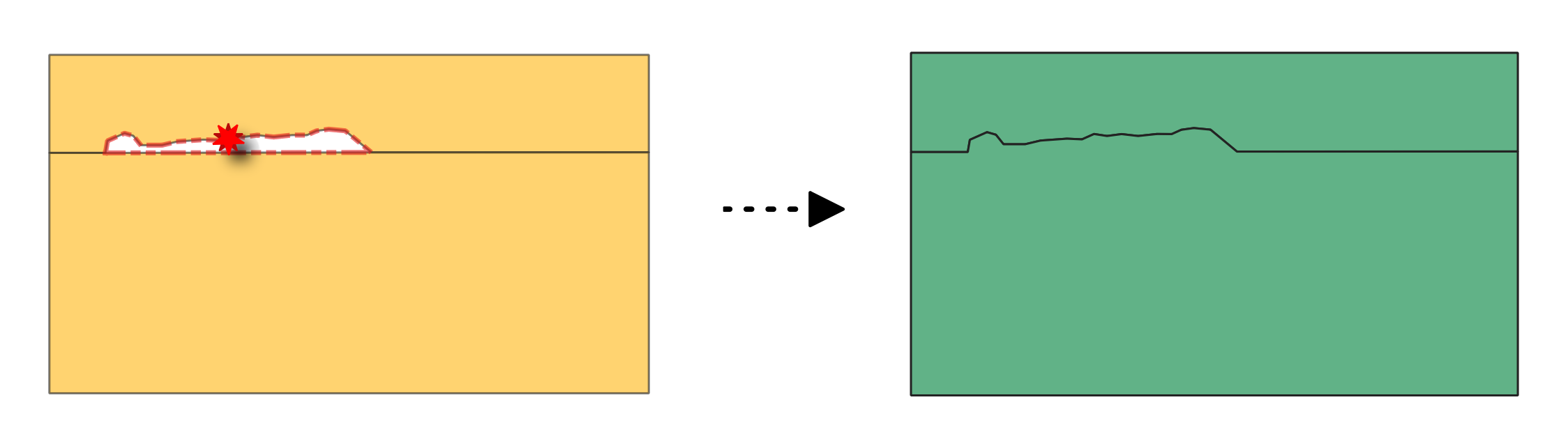
図 24.20 Fixing gap between polygon features using the Add to largest neighbouring area method.
パラメータ
基本パラメータ
ラベル |
名前 |
データ型 |
説明 |
|---|---|---|---|
入力レイヤ |
|
[ベクタ:ポリゴン] |
Layer with the geometries to fix, same as input in the check algorithm. |
Neighbors layer |
|
[ベクタ: テーブル] |
Relational table with the unique ID of the gap and its neighbors in input layer, generated by the check algorithm. |
Gaps layer |
|
[ベクタ:ポリゴン] |
Polygon layer with the gaps geometries, generated by the check algorithm. |
方法 |
|
[列挙型] デフォルト: 0 |
Method to apply to the gap fixing. Possible values are:
|
Field of original feature unique identifier |
|
[テーブルのフィールド:任意] Default: gc_errorid |
Field storing unique values for feature identification in input layer, as set in the check algorithm. |
Field of error id |
|
[テーブルのフィールド:任意] |
Field storing the error ID for each gap, as output by the check algorithm. |
Gaps-filled layer |
|
[ベクタ:ポリゴン] デフォルト: |
Specification of the output layer containing fixed features. One of:
ここでファイルの文字コードを変更することもできます。 |
Report layer from fixing gaps |
|
[ベクタ:ポイント] デフォルト: |
Specification of the output layer containing the fixes location. One of:
ここでファイルの文字コードを変更することもできます。 |
詳細パラメータ
ラベル |
名前 |
データ型 |
説明 |
|---|---|---|---|
許容範囲 |
|
[数値: Integer] デフォルト: 8 |
Numerical precision of geometric operations, given as an integer n, meaning that two vertices less than 10-n apart (in map units) are considered to be merged. |
出力
ラベル |
名前 |
データ型 |
説明 |
|---|---|---|---|
Report layer from fixing gaps |
|
[ベクタ:ポイント] |
Output point layer representing the error locations and fix applied. The output layer contains the following fields:
|
Gaps-filled layer |
|
[ベクタ:ポリゴン] |
Output layer of polygons without gaps. The layer contains the same fields as in the input layer. |
Python コード
Algorithm ID: native:fixgeometrygap
import processing
processing.run("algorithm_id", {parameter_dictionary})
algorithm id は、プロセシングツールボックス内でアルゴリズムにマウスカーソルを乗せた際に表示されるIDです。 parameter dictionary は、パラメータの「名前」とその値を指定するマッピング型です。Python コンソールからプロセシングアルゴリズムを実行する方法の詳細については、 プロセシングアルゴリズムをコンソールから使う を参照してください。
24.1.6.8. Fill holes
Added in 3.42
Deletes holes in polygon geometries based on an error layer from the Holes algorithm.
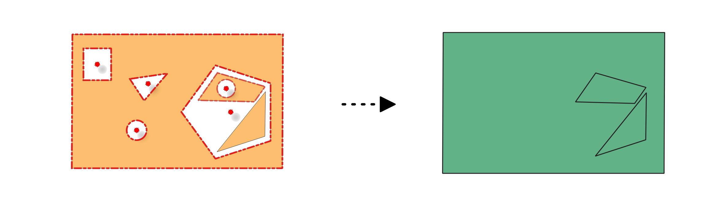
図 24.21 Deleting holes in a polygon feature.
参考
パラメータ
基本パラメータ
ラベル |
名前 |
データ型 |
説明 |
|---|---|---|---|
入力レイヤ |
|
[ベクタ:ライン、ポリゴン] |
Layer with the geometries to fix, same as input in the check algorithm |
Error layer |
|
[ベクタ:ポイント] |
Point layer with the errors location, generated by the check algorithm |
Field of original feature unique identifier |
|
[テーブルのフィールド:任意] |
Field storing unique values for feature identification in input layer, as set in the check algorithm |
Field of part index |
|
[tablefield: integer]
Default: |
Field storing the erroneous feature's geometry part number. |
Field of ring index |
|
[tablefield: integer] Default: |
Field storing the erroneous feature's geometry ring number. |
Field of vertex index |
|
[tablefield: integer] Default: |
Field storing the erroneous feature's geometry vertex number. |
Holes-filled layer |
|
[ベクタ:ポリゴン] デフォルト: |
Specification of the output layer containing fixed features. One of:
ここでファイルの文字コードを変更することもできます。 |
Report layer from fixing holes |
|
[ベクタ:ポイント] デフォルト: |
Specification of the output layer containing the fixes location. One of:
ここでファイルの文字コードを変更することもできます。 |
詳細パラメータ
ラベル |
名前 |
データ型 |
説明 |
|---|---|---|---|
許容範囲 |
|
[数値: Integer] デフォルト: 8 |
Numerical precision of geometric operations, given as an integer n, meaning that two vertices less than 10-n apart (in map units) are considered to be merged. |
出力
ラベル |
名前 |
データ型 |
説明 |
|---|---|---|---|
Report layer from fixing holes |
|
[ベクタ:ポイント] |
Output point layer representing the error locations and fix applied. The output layer contains the following fields:
|
Holes-filled layer |
|
[ベクタ:ポリゴン] |
Output layer of polygons without holes. The layer contains the same fields as in the input layer. |
Python コード
Algorithm ID: native:fixgeometryhole
import processing
processing.run("algorithm_id", {parameter_dictionary})
algorithm id は、プロセシングツールボックス内でアルゴリズムにマウスカーソルを乗せた際に表示されるIDです。 parameter dictionary は、パラメータの「名前」とその値を指定するマッピング型です。Python コンソールからプロセシングアルゴリズムを実行する方法の詳細については、 プロセシングアルゴリズムをコンソールから使う を参照してください。
24.1.6.9. Fix small polygons
Added in 3.42
Merges neighboring polygons according to the chosen method, based on an error layer from the Small polygons or Sliver polygons algorithm.
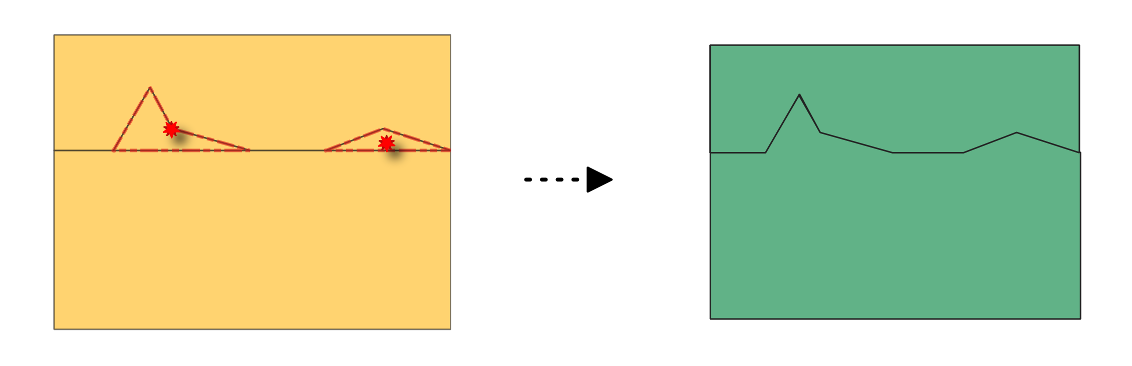
図 24.22 Before and after fixing small polygons (method: merge with neighboring polygon with largest area).
パラメータ
基本パラメータ
ラベル |
名前 |
データ型 |
説明 |
|---|---|---|---|
入力レイヤ |
|
[ベクタ:ポリゴン] |
Layer with the geometries to fix, same as input in the check algorithm. |
Error layer |
|
[ベクタ:ポイント] |
Point layer with the errors location, generated by the check algorithm. |
方法 |
|
[列挙型] デフォルト: 0 |
Method to apply to the small polygon geometries:
|
Field to consider when merging polygons with the identical attribute method オプション |
|
[テーブルのフィールド:任意] |
Field in the input layer to consider when merging polygons with the identical attribute method. |
Field of original feature unique identifier |
|
[テーブルのフィールド:任意] |
Field storing unique values for feature identification in input layer, as set in the check algorithm. |
Field of part index |
|
[tablefield: integer]
Default: |
Field storing the erroneous feature's geometry part number. |
Field of ring index |
|
[tablefield: integer] Default: |
Field storing the erroneous feature's geometry ring number. |
Field of vertex index |
|
[tablefield: integer] Default: |
Field storing the erroneous feature's geometry vertex number. |
Small polygons merged layer |
|
[ベクタ:ポリゴン] デフォルト: |
Specification of the output layer containing fixed features. One of:
ここでファイルの文字コードを変更することもできます。 |
Report layer from merging small polygons |
|
[ベクタ:ポイント] デフォルト: |
Specification of the output layer containing the fixes location. One of:
ここでファイルの文字コードを変更することもできます。 |
詳細パラメータ
ラベル |
名前 |
データ型 |
説明 |
|---|---|---|---|
許容範囲 |
|
[数値: Integer] デフォルト: 8 |
Numerical precision of geometric operations, given as an integer n, meaning that two vertices less than 10-n apart (in map units) are considered to be merged. |
出力
ラベル |
名前 |
データ型 |
説明 |
|---|---|---|---|
Report layer from merging small polygons |
|
[ベクタ:ポイント] |
Output point layer representing the error locations and fix applied. The output layer contains the following fields:
|
Small polygons merged layer |
|
[ベクタ:ポリゴン] |
Output layer of polygons with small polygons merged according to the chosen method. The layer contains the same fields as in the input layer. |
Python コード
Algorithm ID: native:fixgeometryarea
import processing
processing.run("algorithm_id", {parameter_dictionary})
algorithm id は、プロセシングツールボックス内でアルゴリズムにマウスカーソルを乗せた際に表示されるIDです。 parameter dictionary は、パラメータの「名前」とその値を指定するマッピング型です。Python コンソールからプロセシングアルゴリズムを実行する方法の詳細については、 プロセシングアルゴリズムをコンソールから使う を参照してください。
24.1.6.10. Split self-intersecting geometries
Added in 3.42
Splits self-intersecting geometries based on an error layer from the Self-intersections algorithm.
注釈
This algorithm detects invalid polygon geometries (self-intersections).
To ensure these invalid features are not filtered out before processing, open
 Advanced options next to the Input layer and set
Invalid feature filtering to
Advanced options next to the Input layer and set
Invalid feature filtering to Do not Filter (Better Performance).
図 24.23 Fixing self-intersection using various methods: as multi-part (middle), and multiple single-part geometries (right).
パラメータ
基本パラメータ
ラベル |
名前 |
データ型 |
説明 |
|---|---|---|---|
入力レイヤ |
|
[ベクタ:ライン、ポリゴン] |
Layer with the geometries to fix, same as input in the check algorithm |
Error layer |
|
[ベクタ:ポイント] |
Point layer with the errors location, generated by the check algorithm |
方法 |
|
[列挙型] |
Method to apply to the self-intersecting geometries:
|
Field of original feature unique identifier |
|
[テーブルのフィールド:任意] |
Field storing unique values for feature identification in input layer, as set in the check algorithm |
Field of part index |
|
[tablefield: integer] Default: |
Field storing the erroneous feature's geometry part number. |
Field of ring index |
|
[tablefield: integer] Default: |
Field storing the erroneous feature's geometry ring number. |
Field of vertex index |
|
[tablefield: integer] Default: |
Field storing the erroneous feature's geometry vertex number. |
Field of segment 1 |
|
[tablefield: integer] Default: |
Field storing the number of the first segment involved in the erroneous intersection. |
Field of segment 2 |
|
[tablefield: integer] Default: |
Field storing the number of the second segment involved in the erroneous intersection. |
Self-intersections fixed layer |
|
[ベクタ: 入力と同じ] デフォルト: |
Specification of the output layer containing fixed features. One of:
ここでファイルの文字コードを変更することもできます。 |
Report layer from fixing self-intersections |
|
[ベクタ:ポイント] デフォルト: |
Specification of the output layer containing the fixes location. One of:
ここでファイルの文字コードを変更することもできます。 |
詳細パラメータ
ラベル |
名前 |
データ型 |
説明 |
|---|---|---|---|
許容範囲 |
|
[数値: Integer] デフォルト: 8 |
Numerical precision of geometric operations, given as an integer n, meaning that two vertices less than 10-n apart (in map units) are considered to be merged. |
出力
ラベル |
名前 |
データ型 |
説明 |
|---|---|---|---|
Report layer from fixing self-intersections |
|
[ベクタ:ポイント] |
Output point layer representing the error locations and fix applied. The output layer contains the following fields:
|
Self-intersections fixed layer |
|
[ベクタ: 入力と同じ] |
Output layer with the geometry fix applied to the input features. The layer contains the same fields as in the input layer. |
Python コード
Algorithm ID: native:fixgeometryselfintersection
import processing
processing.run("algorithm_id", {parameter_dictionary})
algorithm id は、プロセシングツールボックス内でアルゴリズムにマウスカーソルを乗せた際に表示されるIDです。 parameter dictionary は、パラメータの「名前」とその値を指定するマッピング型です。Python コンソールからプロセシングアルゴリズムを実行する方法の詳細については、 プロセシングアルゴリズムをコンソールから使う を参照してください。