Важно
Перевод - это работа сообщества : ссылка:Вы можете присоединиться. Эта страница в настоящее время переводится |прогресс перевода|.
24.1.6. Fix Geometry
24.1.6.1. Add missing vertices along borders
Added in 3.42
Adds the missing vertices along polygons borders, based on an error layer from the Missing vertices along borders algorithm.
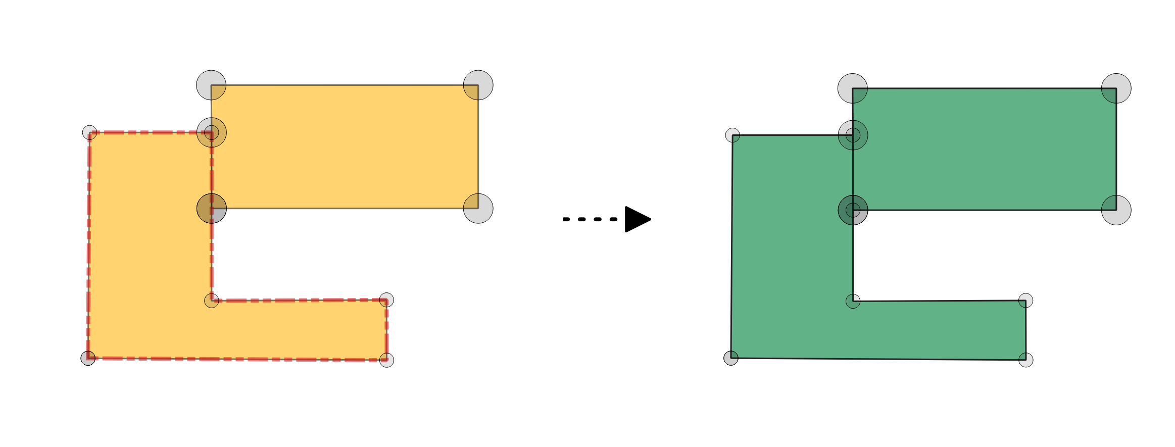
Рис. 24.16 Fixing missing vertices along polygon borders.
Параметры
Basic parameters
Ярлык |
Имя |
Тип |
Описание |
|---|---|---|---|
Исходный слой |
|
[vector: polygon] |
Layer with the geometries to fix, same as input in the check algorithm. |
Error layer |
|
[vector: point] |
Point layer with the errors location, generated by the check algorithm. |
Field of original feature unique identifier |
|
[tablefield: any] |
Field storing unique values for feature identification in input layer, as set in the check algorithm. |
Field of part index |
|
[tablefield: integer] Default: |
Field storing the erroneous feature’s geometry part number. |
Field of ring index |
|
[tablefield: integer] Default: |
Field storing the erroneous feature’s geometry ring number. |
Field of vertex index |
|
[tablefield: integer] Default: |
Field storing the erroneous feature’s geometry vertex number. |
Border vertices fixed layer |
|
[vector: polygon] Default: |
Specification of the output layer containing fixed features. One of:
The file encoding can also be changed here. |
Report layer from fixing border vertices |
|
[vector: point] Default: |
Specification of the output layer containing the fixes location. One of:
The file encoding can also be changed here. |
Advanced parameters
Ярлык |
Имя |
Тип |
Описание |
|---|---|---|---|
Tolerance |
|
[numeric: integer] Default: 8 |
Numerical precision of geometric operations, given as an integer n, meaning that two vertices less than 10-n apart (in map units) are considered to be merged. |
Результаты
Ярлык |
Имя |
Тип |
Описание |
|---|---|---|---|
Report layer from fixing border vertices |
|
[vector: point] |
Output point layer representing the error locations and fix applied. The output layer contains the following fields:
|
Border vertices fixed layer |
|
[vector: polygon] |
Output layer with the geometry fix applied to the input features. The layer contains the same fields as in the input layer. |
Код на Python
Algorithm ID: native:fixgeometrymissingvertex
import processing
processing.run("algorithm_id", {parameter_dictionary})
ID алгоритма отображается при наведении мыши на алгоритм в Инструментах анализа. Словарь parameter dictionary содержит ключи параметров и их значения. См. Изпользование алгоритмов геообработки в консоли для детального описания того, как запускать алгоритмы анализа из консоли Python.
24.1.6.2. Convert to strictly multipart
Added in 3.42
Converts multipart geometries that consists of only one geometry into singlepart geometries, based on an error layer from the Strictly multipart algorithm. Layer geometry type will not be changed and will remain multipart.
См. также
Параметры
Basic parameters
Ярлык |
Имя |
Тип |
Описание |
|---|---|---|---|
Исходный слой |
|
[vector: line, polygon] |
Layer with the geometries to fix, same as input in the check algorithm. |
Error layer |
|
[vector: point] |
Point layer with the errors location, generated by the check algorithm. |
Field of original feature unique identifier |
|
[tablefield: any] |
Field storing unique values for feature identification in input layer, as set in the check algorithm. |
Strictly-multipart layer |
|
[vector: same as input] Default: |
Specification of the output layer containing fixed features. One of:
The file encoding can also be changed here. |
Report layer from fixing multipart |
|
[vector: point] Default: |
Specification of the output layer containing the centroids of the fixed geometries. One of:
The file encoding can also be changed here. |
Advanced parameters
Ярлык |
Имя |
Тип |
Описание |
|---|---|---|---|
Tolerance |
|
[numeric: integer] Default: 8 |
Numerical precision of geometric operations, given as an integer n, meaning that two vertices less than 10-n apart (in map units) are considered to be merged. |
Результаты
Ярлык |
Имя |
Тип |
Описание |
|---|---|---|---|
Report layer from fixing multipart |
|
[vector: point] |
Output point layer representing the error locations and fix applied. The output layer contains the following fields:
|
Strictly-multipart layer |
|
[vector: same as input] |
Output layer with the geometry fix applied to the input features. The layer contains the same fields as in the input layer. |
Код на Python
Algorithm ID: native:fixgeometrymultipart
import processing
processing.run("algorithm_id", {parameter_dictionary})
ID алгоритма отображается при наведении мыши на алгоритм в Инструментах анализа. Словарь parameter dictionary содержит ключи параметров и их значения. См. Изпользование алгоритмов геообработки в консоли для детального описания того, как запускать алгоритмы анализа из консоли Python.
24.1.6.3. Delete duplicated vertices
Added in 3.42
Deletes duplicated vertices from the input geometries, based on errors reported by the Duplicated vertices algorithm.
См. также
Параметры
Basic parameters
Ярлык |
Имя |
Тип |
Описание |
|---|---|---|---|
Исходный слой |
|
[vector: line, polygon] |
Layer with the geometries to fix, same as input in the check algorithm. |
Error layer |
|
[vector: point] |
Point layer with the errors location, generated by the check algorithm. |
Field of original feature unique identifier |
|
[tablefield: any] |
Field storing unique values for feature identification in input layer, as set in the check algorithm. |
Field of part index |
|
[tablefield: integer] Default: |
Field storing the erroneous feature’s geometry part number. |
Field of ring index |
|
[tablefield: integer] Default: |
Field storing the erroneous feature’s geometry ring number. |
Field of vertex index |
|
[tablefield: integer] Default: |
Field storing the erroneous feature’s geometry vertex number. |
Fixed duplicate vertices layer |
|
[vector: same as input] Default: |
Specification of the output layer containing fixed features. One of:
The file encoding can also be changed here. |
Report layer from fixing duplicate vertices |
|
[vector: point] Default: |
Specification of the output layer containing the fixes location. One of:
The file encoding can also be changed here. |
Advanced parameters
Ярлык |
Имя |
Тип |
Описание |
|---|---|---|---|
Tolerance |
|
[numeric: integer] Default: 8 |
Numerical precision of geometric operations, given as an integer n, meaning that two vertices less than 10-n apart (in map units) are considered to be merged. |
Результаты
Ярлык |
Имя |
Тип |
Описание |
|---|---|---|---|
Report layer from fixing duplicate vertices |
|
[vector: point] |
Output point layer representing the error locations and fix applied. The output layer contains the following fields:
|
Fixed duplicate vertices layer |
|
[vector: same as input] |
Output layer with the geometry fix applied to the input features. The layer contains the same fields as in the input layer. |
Код на Python
Algorithm ID: native:fixgeometryduplicatenodes
import processing
processing.run("algorithm_id", {parameter_dictionary})
ID алгоритма отображается при наведении мыши на алгоритм в Инструментах анализа. Словарь parameter dictionary содержит ключи параметров и их значения. См. Изпользование алгоритмов геообработки в консоли для детального описания того, как запускать алгоритмы анализа из консоли Python.
24.1.6.4. Delete features
Added in 3.42
Deletes error features based on an error layer from some check geometry algorithms, such as:
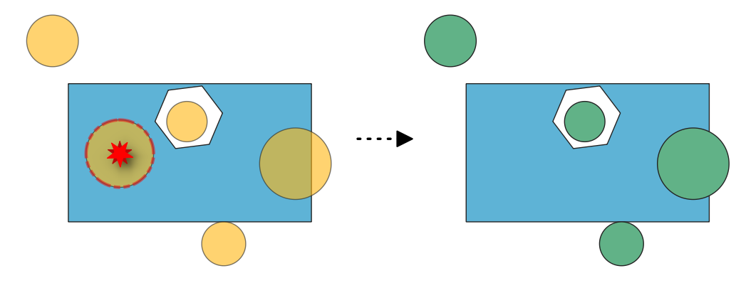
Рис. 24.17 Fixing errors from the «Features inside polygon» algorithm check.
См. также
Параметры
Basic parameters
Ярлык |
Имя |
Тип |
Описание |
|---|---|---|---|
Исходный слой |
|
[vector: geometry] |
Layer with the geometries to fix, same as input in the check algorithm. |
Error layer |
|
[vector: point] |
Point layer with the errors location, generated by the check algorithm. |
Field of original feature unique identifier |
|
[tablefield: any] |
Field storing unique values for feature identification in input layer, as set in the check algorithm. |
Cleaned layer |
|
[vector: same as input] Default: |
Specification of the output layer containing fixed features. One of:
The file encoding can also be changed here. |
Report layer from deleting features |
|
[vector: point] Default: |
Specification of the output layer containing the fixes location. One of:
The file encoding can also be changed here. |
Результаты
Ярлык |
Имя |
Тип |
Описание |
|---|---|---|---|
Report layer from deleting features |
|
[vector: point] |
Output point layer representing the error locations and fix applied. The output layer contains the following fields:
|
Cleaned layer |
|
[vector: same as input] |
Output layer with features removed based on detected errors. The layer contains the same fields as in the input layer. |
Код на Python
Algorithm ID: native:fixgeometrydeletefeatures
import processing
processing.run("algorithm_id", {parameter_dictionary})
ID алгоритма отображается при наведении мыши на алгоритм в Инструментах анализа. Словарь parameter dictionary содержит ключи параметров и их значения. См. Изпользование алгоритмов геообработки в консоли для детального описания того, как запускать алгоритмы анализа из консоли Python.
24.1.6.5. Delete overlaps
Added in 3.42
Deletes overlapping areas based on an error layer from the Overlaps algorithm.
Рис. 24.18 Deleting overlapping areas.
Параметры
Basic parameters
Ярлык |
Имя |
Тип |
Описание |
|---|---|---|---|
Исходный слой |
|
[vector: polygon] |
Layer with the geometries to fix, same as input in the check algorithm. |
Error layer |
|
[vector: point] |
Point layer with the errors location, generated by the check algorithm. |
Field of original feature unique identifier |
|
[tablefield: any] |
Field storing unique values for feature identification in input layer, as set in the check algorithm. |
Field of overlap feature unique identifier |
|
[tablefield: any] |
Field storing unique values for the overlapping feature identification in input layer, as set in the check algorithm. |
Field of error value |
|
[tablefield: any] |
Field storing the error value for each feature, as set in the check algorithm. |
No-overlap layer |
|
[vector: polygon] Default: |
Specification of the output layer containing fixed features. One of:
The file encoding can also be changed here. |
Report layer from fixing overlaps |
|
[vector: point] Default: |
Specification of the output layer containing the fixes location. One of:
The file encoding can also be changed here. |
Advanced parameters
Ярлык |
Имя |
Тип |
Описание |
|---|---|---|---|
Tolerance |
|
[numeric: integer] Default: 8 |
Numerical precision of geometric operations, given as an integer n, meaning that two vertices less than 10-n apart (in map units) are considered to be merged. |
Результаты
Ярлык |
Имя |
Тип |
Описание |
|---|---|---|---|
Report layer from fixing overlaps |
|
[vector: point] |
Output point layer representing the error locations and fix applied. The output layer contains the following fields:
|
No-overlap layer |
|
[vector: polygon] |
Output layer with input features edited. Overlapping areas reported as errors are removed. The layer contains the same fields as in the input layer. |
Код на Python
Algorithm ID: native:fixgeometryoverlap
import processing
processing.run("algorithm_id", {parameter_dictionary})
ID алгоритма отображается при наведении мыши на алгоритм в Инструментах анализа. Словарь parameter dictionary содержит ключи параметров и их значения. См. Изпользование алгоритмов геообработки в консоли для детального описания того, как запускать алгоритмы анализа из консоли Python.
24.1.6.6. Delete small angles
Added in 3.42
Deletes vertices based on an error layer from the Small angles algorithm. When deletion of a vertex results in a duplicate vertex (when a spike vertex is deleted), the duplicate vertex is deleted to keep a single vertex and preserve topology.
Внимание
This algorithm removes the vertex at the reported small angles, generating new segments that may form a new small angle.

Рис. 24.19 Fixing reported errors on a line feature for angles lower than 15°.
Параметры
Basic parameters
Ярлык |
Имя |
Тип |
Описание |
|---|---|---|---|
Исходный слой |
|
[vector: line, polygon] |
Layer with the geometries to fix, same as input in the check algorithm |
Error layer |
|
[vector: point] |
Point layer with the errors location, generated by the check algorithm |
Field of original feature unique identifier |
|
[tablefield: any] |
Field storing unique values for feature identification in input layer, as set in the check algorithm |
Field of part index |
|
[tablefield: integer] Default: |
Field storing the erroneous feature’s geometry part number. |
Field of ring index |
|
[tablefield: integer] Default: |
Field storing the erroneous feature’s geometry ring number. |
Field of vertex index |
|
[tablefield: integer] Default: |
Field storing the erroneous feature’s geometry vertex number. |
Small angle fixed layer |
|
[vector: same as input] Default: |
Specification of the output layer containing fixed features. One of:
The file encoding can also be changed here. |
Report layer from fixing small angles |
|
[vector: point] Default: |
Specification of the output layer containing the fixes location. One of:
The file encoding can also be changed here. |
Advanced parameters
Ярлык |
Имя |
Тип |
Описание |
|---|---|---|---|
Tolerance |
|
[numeric: integer] Default: 8 |
Numerical precision of geometric operations, given as an integer n, meaning that two vertices less than 10-n apart (in map units) are considered to be merged. |
Результаты
Ярлык |
Имя |
Тип |
Описание |
|---|---|---|---|
Report layer from fixing small angles |
|
[vector: point] |
Output point layer representing the error locations and fix applied. The output layer contains the following fields:
|
Small angle fixed layer |
|
[same as input] |
Output layer with the geometry fix applied to the input features. The layer contains the same fields as in the input layer. |
Код на Python
Algorithm ID: native:fixgeometryangle
import processing
processing.run("algorithm_id", {parameter_dictionary})
ID алгоритма отображается при наведении мыши на алгоритм в Инструментах анализа. Словарь parameter dictionary содержит ключи параметров и их значения. См. Изпользование алгоритмов геообработки в консоли для детального описания того, как запускать алгоритмы анализа из консоли Python.
24.1.6.7. Fill gaps
Added in 3.42
Fills the gaps based on a gap and neighbors layer from the Small gaps algorithm. Three different fixing methods are available.
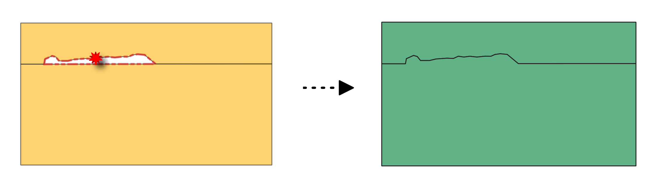
Рис. 24.20 Fixing gap between polygon features using the Add to largest neighbouring area method.
Параметры
Basic parameters
Ярлык |
Имя |
Тип |
Описание |
|---|---|---|---|
Исходный слой |
|
[vector: polygon] |
Layer with the geometries to fix, same as input in the check algorithm. |
Neighbors layer |
|
[vector: table] |
Relational table with the unique ID of the gap and its neighbors in input layer, generated by the check algorithm. |
Gaps layer |
|
[vector: polygon] |
Polygon layer with the gaps geometries, generated by the check algorithm. |
Method |
|
[enumeration] Default: 0 |
Method to apply to the gap fixing. Possible values are:
|
Field of original feature unique identifier |
|
[tablefield: any] Default: gc_errorid |
Field storing unique values for feature identification in input layer, as set in the check algorithm. |
Field of error id |
|
[tablefield: any] |
Field storing the error ID for each gap, as output by the check algorithm. |
Gaps-filled layer |
|
[vector: polygon] Default: |
Specification of the output layer containing fixed features. One of:
The file encoding can also be changed here. |
Report layer from fixing gaps |
|
[vector: point] Default: |
Specification of the output layer containing the fixes location. One of:
The file encoding can also be changed here. |
Advanced parameters
Ярлык |
Имя |
Тип |
Описание |
|---|---|---|---|
Tolerance |
|
[numeric: integer] Default: 8 |
Numerical precision of geometric operations, given as an integer n, meaning that two vertices less than 10-n apart (in map units) are considered to be merged. |
Результаты
Ярлык |
Имя |
Тип |
Описание |
|---|---|---|---|
Report layer from fixing gaps |
|
[vector: point] |
Output point layer representing the error locations and fix applied. The output layer contains the following fields:
|
Gaps-filled layer |
|
[vector: polygon] |
Output layer of polygons without gaps. The layer contains the same fields as in the input layer. |
Код на Python
Algorithm ID: native:fixgeometrygap
import processing
processing.run("algorithm_id", {parameter_dictionary})
ID алгоритма отображается при наведении мыши на алгоритм в Инструментах анализа. Словарь parameter dictionary содержит ключи параметров и их значения. См. Изпользование алгоритмов геообработки в консоли для детального описания того, как запускать алгоритмы анализа из консоли Python.
24.1.6.8. Fill holes
Added in 3.42
Deletes holes in polygon geometries based on an error layer from the Holes algorithm.
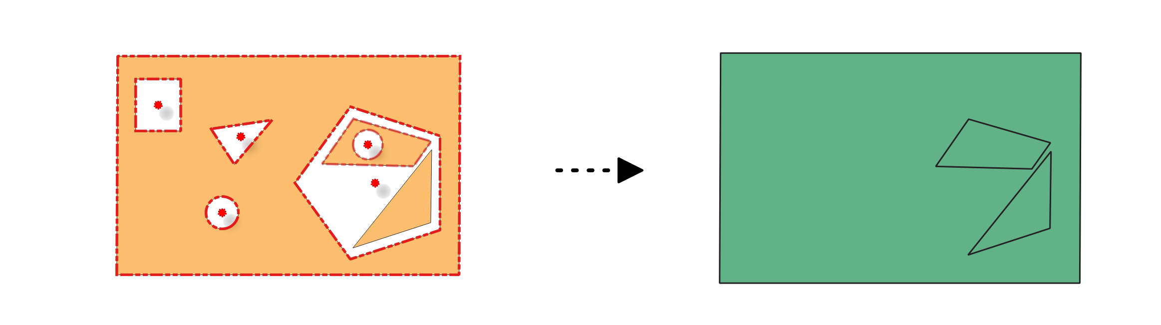
Рис. 24.21 Deleting holes in a polygon feature.
См. также
Параметры
Basic parameters
Ярлык |
Имя |
Тип |
Описание |
|---|---|---|---|
Исходный слой |
|
[vector: line, polygon] |
Layer with the geometries to fix, same as input in the check algorithm |
Error layer |
|
[vector: point] |
Point layer with the errors location, generated by the check algorithm |
Field of original feature unique identifier |
|
[tablefield: any] |
Field storing unique values for feature identification in input layer, as set in the check algorithm |
Field of part index |
|
[tablefield: integer]
Default: |
Field storing the erroneous feature’s geometry part number. |
Field of ring index |
|
[tablefield: integer] Default: |
Field storing the erroneous feature’s geometry ring number. |
Field of vertex index |
|
[tablefield: integer] Default: |
Field storing the erroneous feature’s geometry vertex number. |
Holes-filled layer |
|
[vector: polygon] Default: |
Specification of the output layer containing fixed features. One of:
The file encoding can also be changed here. |
Report layer from fixing holes |
|
[vector: point] Default: |
Specification of the output layer containing the fixes location. One of:
The file encoding can also be changed here. |
Advanced parameters
Ярлык |
Имя |
Тип |
Описание |
|---|---|---|---|
Tolerance |
|
[numeric: integer] Default: 8 |
Numerical precision of geometric operations, given as an integer n, meaning that two vertices less than 10-n apart (in map units) are considered to be merged. |
Результаты
Ярлык |
Имя |
Тип |
Описание |
|---|---|---|---|
Report layer from fixing holes |
|
[vector: point] |
Output point layer representing the error locations and fix applied. The output layer contains the following fields:
|
Holes-filled layer |
|
[vector: polygon] |
Output layer of polygons without holes. The layer contains the same fields as in the input layer. |
Код на Python
Algorithm ID: native:fixgeometryhole
import processing
processing.run("algorithm_id", {parameter_dictionary})
ID алгоритма отображается при наведении мыши на алгоритм в Инструментах анализа. Словарь parameter dictionary содержит ключи параметров и их значения. См. Изпользование алгоритмов геообработки в консоли для детального описания того, как запускать алгоритмы анализа из консоли Python.
24.1.6.9. Fix small polygons
Added in 3.42
Merges neighboring polygons according to the chosen method, based on an error layer from the Small polygons or Sliver polygons algorithm.
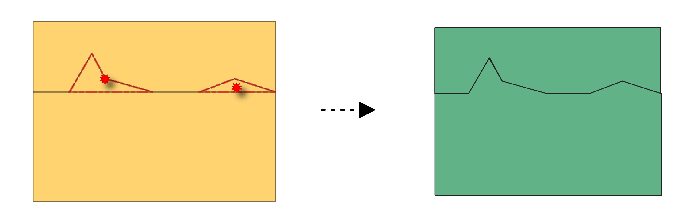
Рис. 24.22 Before and after fixing small polygons (method: merge with neighboring polygon with largest area).
Параметры
Basic parameters
Ярлык |
Имя |
Тип |
Описание |
|---|---|---|---|
Исходный слой |
|
[vector: polygon] |
Layer with the geometries to fix, same as input in the check algorithm. |
Error layer |
|
[vector: point] |
Point layer with the errors location, generated by the check algorithm. |
Method |
|
[enumeration] Default: 0 |
Method to apply to the small polygon geometries:
|
Field to consider when merging polygons with the identical attribute method Optional |
|
[tablefield: any] |
Field in the input layer to consider when merging polygons with the identical attribute method. |
Field of original feature unique identifier |
|
[tablefield: any] |
Field storing unique values for feature identification in input layer, as set in the check algorithm. |
Field of part index |
|
[tablefield: integer]
Default: |
Field storing the erroneous feature’s geometry part number. |
Field of ring index |
|
[tablefield: integer] Default: |
Field storing the erroneous feature’s geometry ring number. |
Field of vertex index |
|
[tablefield: integer] Default: |
Field storing the erroneous feature’s geometry vertex number. |
Small polygons merged layer |
|
[vector: polygon] Default: |
Specification of the output layer containing fixed features. One of:
The file encoding can also be changed here. |
Report layer from merging small polygons |
|
[vector: point] Default: |
Specification of the output layer containing the fixes location. One of:
The file encoding can also be changed here. |
Advanced parameters
Ярлык |
Имя |
Тип |
Описание |
|---|---|---|---|
Tolerance |
|
[numeric: integer] Default: 8 |
Numerical precision of geometric operations, given as an integer n, meaning that two vertices less than 10-n apart (in map units) are considered to be merged. |
Результаты
Ярлык |
Имя |
Тип |
Описание |
|---|---|---|---|
Report layer from merging small polygons |
|
[vector: point] |
Output point layer representing the error locations and fix applied. The output layer contains the following fields:
|
Small polygons merged layer |
|
[vector: polygon] |
Output layer of polygons with small polygons merged according to the chosen method. The layer contains the same fields as in the input layer. |
Код на Python
Algorithm ID: native:fixgeometryarea
import processing
processing.run("algorithm_id", {parameter_dictionary})
ID алгоритма отображается при наведении мыши на алгоритм в Инструментах анализа. Словарь parameter dictionary содержит ключи параметров и их значения. См. Изпользование алгоритмов геообработки в консоли для детального описания того, как запускать алгоритмы анализа из консоли Python.
24.1.6.10. Split self-intersecting geometries
Added in 3.42
Splits self-intersecting geometries based on an error layer from the Self-intersections algorithm.
Примечание
This algorithm detects invalid polygon geometries (self-intersections).
To ensure these invalid features are not filtered out before processing, open
 Advanced options next to the Input layer and set
Invalid feature filtering to
Advanced options next to the Input layer and set
Invalid feature filtering to Do not Filter (Better Performance).
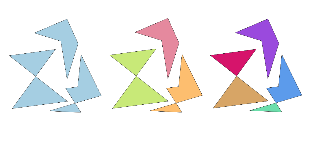
Рис. 24.23 Fixing self-intersection using various methods: as multi-part (middle), and multiple single-part geometries (right).
Параметры
Basic parameters
Ярлык |
Имя |
Тип |
Описание |
|---|---|---|---|
Исходный слой |
|
[vector: line, polygon] |
Layer with the geometries to fix, same as input in the check algorithm |
Error layer |
|
[vector: point] |
Point layer with the errors location, generated by the check algorithm |
Method |
|
[enumeration] |
Method to apply to the self-intersecting geometries:
|
Field of original feature unique identifier |
|
[tablefield: any] |
Field storing unique values for feature identification in input layer, as set in the check algorithm |
Field of part index |
|
[tablefield: integer] Default: |
Field storing the erroneous feature’s geometry part number. |
Field of ring index |
|
[tablefield: integer] Default: |
Field storing the erroneous feature’s geometry ring number. |
Field of vertex index |
|
[tablefield: integer] Default: |
Field storing the erroneous feature’s geometry vertex number. |
Field of segment 1 |
|
[tablefield: integer] Default: |
Field storing the number of the first segment involved in the erroneous intersection. |
Field of segment 2 |
|
[tablefield: integer] Default: |
Field storing the number of the second segment involved in the erroneous intersection. |
Self-intersections fixed layer |
|
[vector: same as input] Default: |
Specification of the output layer containing fixed features. One of:
The file encoding can also be changed here. |
Report layer from fixing self-intersections |
|
[vector: point] Default: |
Specification of the output layer containing the fixes location. One of:
The file encoding can also be changed here. |
Advanced parameters
Ярлык |
Имя |
Тип |
Описание |
|---|---|---|---|
Tolerance |
|
[numeric: integer] Default: 8 |
Numerical precision of geometric operations, given as an integer n, meaning that two vertices less than 10-n apart (in map units) are considered to be merged. |
Результаты
Ярлык |
Имя |
Тип |
Описание |
|---|---|---|---|
Report layer from fixing self-intersections |
|
[vector: point] |
Output point layer representing the error locations and fix applied. The output layer contains the following fields:
|
Self-intersections fixed layer |
|
[vector: same as input] |
Output layer with the geometry fix applied to the input features. The layer contains the same fields as in the input layer. |
Код на Python
Algorithm ID: native:fixgeometryselfintersection
import processing
processing.run("algorithm_id", {parameter_dictionary})
ID алгоритма отображается при наведении мыши на алгоритм в Инструментах анализа. Словарь parameter dictionary содержит ключи параметров и их значения. См. Изпользование алгоритмов геообработки в консоли для детального описания того, как запускать алгоритмы анализа из консоли Python.