27.1.17. Vector general
27.1.17.1. Assign projection
Assigns a new projection to a vector layer.
It creates a new layer with the exact same features and geometries as the input one, but assigned to a new CRS. The geometries are not reprojected, they are just assigned to a different CRS.
This algorithm can be used to repair layers which have been assigned an incorrect projection.
Attributes are not modified by this algorithm.
参数
标注 |
名称 |
类型 |
描述 |
|---|---|---|---|
输入图层 |
|
[vector: any] |
Vector layer with wrong or missing CRS |
Assigned CRS |
|
[crs] Default: |
Select the new CRS to assign to the vector layer |
Assigned CRS 可选 |
|
[same as input] Default: |
Specify the output vector layer. One of:
文件编码也可以在此更改。 |
输出
标注 |
名称 |
类型 |
描述 |
|---|---|---|---|
Assigned CRS |
|
[same as input] |
Vector layer with assigned projection |
Python代码
Algorithm ID: native:assignprojection
import processing
processing.run("algorithm_id", {parameter_dictionary})
当你在数据处理工具箱某个算法前悬停时,算法 id 将会展现。*参数字*将会提供参数的名称与数值。参考详见`数据处理_控制台`以获取如何从Python控制台中运行数据处理算法。
27.1.17.2. Batch Nominatim geocoder
Performs batch geocoding using the Nominatim service against an input layer string field. The output layer will have a point geometry reflecting the geocoded location as well as a number of attributes associated to the geocoded location.
 Allows
features in-place modification
of point features
Allows
features in-place modification
of point features
备注
This algorithm is compliant with the usage policy of the Nominatim geocoding service provided by the OpenStreetMap Foundation.
参数
标注 |
名称 |
类型 |
描述 |
|---|---|---|---|
输入图层 |
|
[vector: any] |
Vector layer to geocode the features |
Address field |
|
[tablefield: string] |
Field containing the addresses to geocode |
Geocoded |
|
[vector: point] Default: |
Specify the output layer containing only the geocoded addresses. One of:
文件编码也可以在此更改。 |
输出
标注 |
名称 |
类型 |
描述 |
|---|---|---|---|
Geocoded |
|
[vector: point] |
Vector layer with point features corresponding to the geocoded addresses |
Python代码
Algorithm ID: native:batchnominatimgeocoder
import processing
processing.run("algorithm_id", {parameter_dictionary})
当你在数据处理工具箱某个算法前悬停时,算法 id 将会展现。*参数字*将会提供参数的名称与数值。参考详见`数据处理_控制台`以获取如何从Python控制台中运行数据处理算法。
27.1.17.3. Convert layer to spatial bookmarks
Creates spatial bookmarks corresponding to the extent of features contained in a layer.
参数
标注 |
名称 |
类型 |
描述 |
|---|---|---|---|
Input Layer |
|
[vector: line, polygon] |
The input vector layer |
Bookmark destination |
|
[enumeration] Default: 0 |
Select the destination for the bookmarks. One of:
|
Name field |
|
[expression] |
Field or expression that will give names to the generated bookmarks |
Group field |
|
[expression] |
Field or expression that will provide groups for the generated bookmarks |
输出
标注 |
名称 |
类型 |
描述 |
|---|---|---|---|
Count of bookmarks added |
|
[数字] |
Python代码
Algorithm ID: native:layertobookmarks
import processing
processing.run("algorithm_id", {parameter_dictionary})
当你在数据处理工具箱某个算法前悬停时,算法 id 将会展现。*参数字*将会提供参数的名称与数值。参考详见`数据处理_控制台`以获取如何从Python控制台中运行数据处理算法。
27.1.17.4. Convert spatial bookmarks to layer
Creates a new layer containing polygon features for stored spatial bookmarks. The export can be filtered to only bookmarks belonging to the current project, to all user bookmarks, or a combination of both.
参数
标注 |
名称 |
类型 |
描述 |
|---|---|---|---|
Bookmark source |
|
[enumeration] [list] Default: [0,1] |
Select the source(s) of the bookmarks. One or more of:
|
Output CRS |
|
[crs] Default: |
The CRS of the output layer |
Output |
|
[vector: polygon] Default: |
Specify the output layer. One of:
文件编码也可以在此更改。 |
输出
标注 |
名称 |
类型 |
描述 |
|---|---|---|---|
Output |
|
[vector: polygon] |
The output (bookmarks) vector layer |
Python代码
Algorithm ID: native:bookmarkstolayer
import processing
processing.run("algorithm_id", {parameter_dictionary})
当你在数据处理工具箱某个算法前悬停时,算法 id 将会展现。*参数字*将会提供参数的名称与数值。参考详见`数据处理_控制台`以获取如何从Python控制台中运行数据处理算法。
27.1.17.5. Create attribute index
Creates an index against a field of the attribute table to speed up queries. The support for index creation depends on both the layer's data provider and the field type.
No outputs are created: the index is stored on the layer itself.
参数
标注 |
名称 |
类型 |
描述 |
|---|---|---|---|
Input Layer |
|
[vector: any] |
Select the vector layer you want to create an attribute index for |
Attribute to index |
|
[tablefield: any] |
Field of the vector layer |
输出
标注 |
名称 |
类型 |
描述 |
|---|---|---|---|
Indexed layer |
|
[same as input] |
A copy of the input vector layer with an index for the specified field |
Python代码
Algorithm ID: native:createattributeindex
import processing
processing.run("algorithm_id", {parameter_dictionary})
当你在数据处理工具箱某个算法前悬停时,算法 id 将会展现。*参数字*将会提供参数的名称与数值。参考详见`数据处理_控制台`以获取如何从Python控制台中运行数据处理算法。
27.1.17.6. Create spatial index
Creates an index to speed up access to the features in a layer based on their spatial location. Support for spatial index creation is dependent on the layer's data provider.
No new output layers are created.
Default menu:
参数
标注 |
名称 |
类型 |
描述 |
|---|---|---|---|
Input Layer |
|
[vector: any] |
Input vector layer |
输出
标注 |
名称 |
类型 |
描述 |
|---|---|---|---|
Indexed layer |
|
[same as input] |
A copy of the input vector layer with a spatial index |
Python代码
Algorithm ID: native:createspatialindex
import processing
processing.run("algorithm_id", {parameter_dictionary})
当你在数据处理工具箱某个算法前悬停时,算法 id 将会展现。*参数字*将会提供参数的名称与数值。参考详见`数据处理_控制台`以获取如何从Python控制台中运行数据处理算法。
27.1.17.7. Define Shapefile projection
Sets the CRS (projection) of an existing Shapefile format dataset to
the provided CRS.
It is very useful when a Shapefile format dataset is missing the
prj file and you know the correct projection.
Contrary to the Assign projection algorithm, it modifies the current layer and will not output a new layer.
备注
For Shapefile datasets, the .prj and .qpj files will
be overwritten - or created if missing - to match the provided CRS.
Default menu:
参数
标注 |
名称 |
类型 |
描述 |
|---|---|---|---|
输入图层 |
|
[vector: any] |
Vector layer with missing projection information |
CRS |
|
[crs] |
Select the CRS to assign to the vector layer |
输出
标注 |
名称 |
类型 |
描述 |
|---|---|---|---|
|
[same as input] |
The input vector layer with the defined projection |
Python代码
Algorithm ID: qgis:definecurrentprojection
import processing
processing.run("algorithm_id", {parameter_dictionary})
当你在数据处理工具箱某个算法前悬停时,算法 id 将会展现。*参数字*将会提供参数的名称与数值。参考详见`数据处理_控制台`以获取如何从Python控制台中运行数据处理算法。
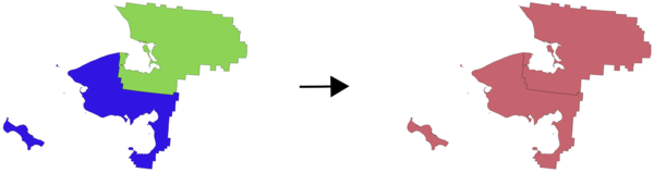
27.1.17.8. Delete duplicate geometries
Finds and removes duplicated geometries.
Attributes are not checked, so in case two features have identical geometries but different attributes, only one of them will be added to the result layer.
参数
标注 |
名称 |
类型 |
描述 |
|---|---|---|---|
输入图层 |
|
[vector: any] |
The layer with duplicate geometries you want to clean |
Cleaned |
|
[same as input] Default: |
Specify the output layer. One of:
文件编码也可以在此更改。 |
输出
标注 |
名称 |
类型 |
描述 |
|---|---|---|---|
Count of discarded duplicate records |
|
[数字] |
Count of discarded duplicate records |
Cleaned |
|
[same as input] |
The output layer without any duplicated geometries |
Count of retained records |
|
[数字] |
Count of unique records |
Python代码
Algorithm ID: native:deleteduplicategeometries
import processing
processing.run("algorithm_id", {parameter_dictionary})
当你在数据处理工具箱某个算法前悬停时,算法 id 将会展现。*参数字*将会提供参数的名称与数值。参考详见`数据处理_控制台`以获取如何从Python控制台中运行数据处理算法。
27.1.17.9. Delete duplicates by attribute
Deletes duplicate rows by only considering the specified field / fields. The first matching row will be retained, and duplicates will be discarded.
Optionally, these duplicate records can be saved to a separate output for analysis.
参数
标注 |
名称 |
类型 |
描述 |
|---|---|---|---|
输入图层 |
|
[vector: any] |
The input layer |
Fields to match duplicates by |
|
[tablefield: any] [list] |
Fields defining duplicates. Features with identical values for all these fields are considered duplicates. |
Filtered (no duplicates) |
|
[same as input] Default: |
Specify the output layer containing the unique features. One of:
文件编码也可以在此更改。 |
Filtered (duplicates) 可选 |
|
[same as input] Default: |
Specify the output layer containing only the duplicates. One of:
文件编码也可以在此更改。 |
输出
标注 |
名称 |
类型 |
描述 |
|---|---|---|---|
Filtered (duplicates) 可选 |
|
[same as input] Default: |
Vector layer containing the removed features.
Will not be produced if not specified (left as
|
Count of discarded duplicate records |
|
[数字] |
Count of discarded duplicate records |
Filtered (no duplicates) |
|
[same as input] |
Vector layer containing the unique features. |
Count of retained records |
|
[数字] |
Count of unique records |
Python代码
Algorithm ID: native:removeduplicatesbyattribute
import processing
processing.run("algorithm_id", {parameter_dictionary})
当你在数据处理工具箱某个算法前悬停时,算法 id 将会展现。*参数字*将会提供参数的名称与数值。参考详见`数据处理_控制台`以获取如何从Python控制台中运行数据处理算法。
27.1.17.10. Detect dataset changes
Compares two vector layers, and determines which features are unchanged, added or deleted between the two. It is designed for comparing two different versions of the same dataset.
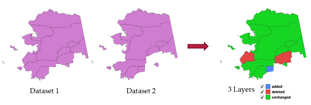
图 27.46 Detect dataset change example
参数
标注 |
名称 |
类型 |
描述 |
|---|---|---|---|
Original layer |
|
[vector: any] |
The vector layer considered as the original version |
Revised layer |
|
[vector: any] |
The revised or modified vector layer |
Attributes to consider for match 可选 |
|
[tablefield: any] [list] |
Attributes to consider for match. By default, all attributes are compared. |
Geometry comparison behavior 可选 |
|
[enumeration] Default: 1 |
Defines the criteria for comparison. Options:
|
Unchanged features 可选 |
|
[vector: same as Original layer] |
Specify the output vector layer containing the unchanged features. One of:
文件编码也可以在此更改。 |
Added features 可选 |
|
[vector: same as Original layer] |
Specify the output vector layer containing the added features. One of:
文件编码也可以在此更改。 |
Deleted features 可选 |
|
[vector: same as Original layer] |
Specify the output vector layer containing the deleted features. One of:
文件编码也可以在此更改。 |
输出
标注 |
名称 |
类型 |
描述 |
|---|---|---|---|
Unchanged features |
|
[vector: same as Original layer] |
Vector layer containing the unchanged features. |
Added features |
|
[vector: same as Original layer] |
Vector layer containing the added features. |
Deleted features |
|
[vector: same as Original layer] |
Vector layer containing the deleted features. |
Count of unchanged features |
|
[数字] |
Count of unchanged features. |
Count of features added in revised layer |
|
[数字] |
Count of features added in revised layer. |
Count of features deleted from original layer |
|
[数字] |
Count of features deleted from original layer. |
Python代码
Algorithm ID: native:detectvectorchanges
import processing
processing.run("algorithm_id", {parameter_dictionary})
当你在数据处理工具箱某个算法前悬停时,算法 id 将会展现。*参数字*将会提供参数的名称与数值。参考详见`数据处理_控制台`以获取如何从Python控制台中运行数据处理算法。
27.1.17.11. Drop geometries
Creates a simple geometryless copy of the input layer attribute table. It keeps the attribute table of the source layer.
If the file is saved in a local folder, you can choose between many file formats.
Allows features in-place modification
of point, line, and polygon features
参数
标注 |
名称 |
类型 |
描述 |
|---|---|---|---|
输入图层 |
|
[vector: any] |
The input vector layer |
Dropped geometries |
|
[table] |
Specify the output geometryless layer. One of:
文件编码也可以在此更改。 |
输出
标注 |
名称 |
类型 |
描述 |
|---|---|---|---|
Dropped geometries |
|
[table] |
The output geometryless layer. A copy of the original attribute table. |
Python代码
Algorithm ID: native:dropgeometries
import processing
processing.run("algorithm_id", {parameter_dictionary})
当你在数据处理工具箱某个算法前悬停时,算法 id 将会展现。*参数字*将会提供参数的名称与数值。参考详见`数据处理_控制台`以获取如何从Python控制台中运行数据处理算法。
27.1.17.12. Execute SQL
Runs a simple or complex query with SQL syntax on the source
layer.
Input datasources are identified with input1, input2... inputN and
a simple query will look like SELECT * FROM input1.
Beside a simple query, you can add expressions or variables within the
SQL query parameter itself. This is particulary useful if this algorithm is
executed within a Processing model and you want to use a model input as a
parameter of the query. An example of a query will then be SELECT * FROM
[% @table %] where @table is the variable that identifies the model input.
The result of the query will be added as a new layer.
参数
标注 |
名称 |
类型 |
描述 |
|---|---|---|---|
Additional input datasources (called input1, .., inputN in the query) |
|
[vector: any] [list] |
List of layers to query. In the SQL editor you can refer these layers with their real name or also with input1, input2, inputN depending on how many layers have been chosen. |
SQL query |
|
[string] |
Type the string of your SQL query, e.g.
|
Unique identifier field 可选 |
|
[string] |
Specify the column with unique ID |
Geometry field 可选 |
|
[string] |
Specify the geometry field |
Geometry type 可选 |
|
[enumeration] Default: 0 |
Choose the geometry of the result. By default the algorithm will autodetect it. One of:
|
CRS 可选 |
|
[crs] |
The CRS to assign to the output layer |
SQL Output |
|
[vector: any] Default: |
Specify the output layer created by the query. One of:
文件编码也可以在此更改。 |
输出
标注 |
名称 |
类型 |
描述 |
|---|---|---|---|
SQL Output |
|
[vector: any] |
Vector layer created by the query |
Python代码
Algorithm ID: qgis:executesql
import processing
processing.run("algorithm_id", {parameter_dictionary})
当你在数据处理工具箱某个算法前悬停时,算法 id 将会展现。*参数字*将会提供参数的名称与数值。参考详见`数据处理_控制台`以获取如何从Python控制台中运行数据处理算法。
27.1.17.13. Export layers to DXF
Exports layers to DXF file. For each layer, you can choose a field whose values are used to split features in generated destination layers in DXF output.
参见
参数
标注 |
名称 |
类型 |
描述 |
|---|---|---|---|
Input layers |
|
[vector: any] [list] |
Input vector layers to export |
Symbology mode |
|
[enumeration] Default: 0 |
Type of symbology to apply to output layers. You can choose between:
|
Symbology scale |
|
[scale] Default: 1:1 000 000 |
Default scale of data export. |
Encoding |
|
[enumeration] |
Encoding to apply to layers. |
CRS |
|
[crs] |
Choose the CRS for the output layer. |
Use layer title as name |
|
[boolean] Default: False |
Name the output layer with the layer title (as set in QGIS) instead of the layer name. |
Force 2D |
|
[boolean] Default: False |
|
Export labels as MTEXT elements |
|
[boolean] Default: False |
Exports labels as MTEXT or TEXT elements |
DXF |
|
[file] 默认: |
Specification of the output DXF file. One of:
|
输出
标注 |
名称 |
类型 |
描述 |
|---|---|---|---|
DXF |
|
[file] |
|
Python代码
Algorithm ID: native:dxfexport
import processing
processing.run("algorithm_id", {parameter_dictionary})
当你在数据处理工具箱某个算法前悬停时,算法 id 将会展现。*参数字*将会提供参数的名称与数值。参考详见`数据处理_控制台`以获取如何从Python控制台中运行数据处理算法。
27.1.17.14. Extract selected features
Saves the selected features as a new layer.
备注
If the selected layer has no selected features, the newly created layer will be empty.
参数
标注 |
名称 |
类型 |
描述 |
|---|---|---|---|
Input Layer |
|
[vector: any] |
Layer to save the selection from |
Selected features |
|
[same as input] Default: |
Specify the vector layer for the selected features. One of:
文件编码也可以在此更改。 |
输出
标注 |
名称 |
类型 |
描述 |
|---|---|---|---|
Selected features |
|
[same as input] |
Vector layer with only the selected features, or no feature if none was selected. |
Python代码
Algorithm ID: native:saveselectedfeatures
import processing
processing.run("algorithm_id", {parameter_dictionary})
当你在数据处理工具箱某个算法前悬停时,算法 id 将会展现。*参数字*将会提供参数的名称与数值。参考详见`数据处理_控制台`以获取如何从Python控制台中运行数据处理算法。
27.1.17.15. Extract Shapefile encoding
Extracts the attribute encoding information embedded in a Shapefile.
Both the encoding specified by an optional .cpg file and
any encoding details present in the .dbf LDID header block are considered.
参数
标注 |
名称 |
类型 |
描述 |
|---|---|---|---|
Input Layer |
|
[vector: any] |
ESRI Shapefile ( |
输出
标注 |
名称 |
类型 |
描述 |
|---|---|---|---|
Shapefile encoding |
|
[string] |
Encoding information specified in the input file |
CPG encoding |
|
[string] |
Encoding information specified in any optional |
LDID encoding |
|
[string] |
Encoding information specified in |
Python代码
Algorithm ID: native:shpencodinginfo
import processing
processing.run("algorithm_id", {parameter_dictionary})
当你在数据处理工具箱某个算法前悬停时,算法 id 将会展现。*参数字*将会提供参数的名称与数值。参考详见`数据处理_控制台`以获取如何从Python控制台中运行数据处理算法。
27.1.17.16. Find projection
Creates a shortlist of candidate coordinate reference systems, for instance for a layer with an unknown projection.
The area that the layer is expected to cover must be specified via the target area parameter. The coordinate reference system for this target area must be known to QGIS.
The algorithm operates by testing the layer's extent in every known reference system and then listing any for which the bounds would be near the target area if the layer was in this projection.
参数
标注 |
名称 |
类型 |
描述 |
|---|---|---|---|
Input Layer |
|
[vector: any] |
Layer with unknown projection |
Target area for layer (xmin, xmax, ymin, ymax) |
|
[范围] |
The area that the layer covers. Available methods are:
|
CRS candidates |
|
[table] Default: |
Specify the table (geometryless layer) for the CRS suggestions (EPSG codes). One of:
文件编码也可以在此更改。 |
输出
标注 |
名称 |
类型 |
描述 |
|---|---|---|---|
CRS candidates |
|
[table] |
A table with all the CRS (EPSG codes) of the matching criteria. |
Python代码
Algorithm ID: qgis:findprojection
import processing
processing.run("algorithm_id", {parameter_dictionary})
当你在数据处理工具箱某个算法前悬停时,算法 id 将会展现。*参数字*将会提供参数的名称与数值。参考详见`数据处理_控制台`以获取如何从Python控制台中运行数据处理算法。
27.1.17.17. Flatten relationship
Flattens a relationship for a vector layer, exporting a single layer containing one parent feature per related child feature. This master feature contains all the attributes for the related features. This allows to have the relation as a plain table that can be e.g. exported to CSV.
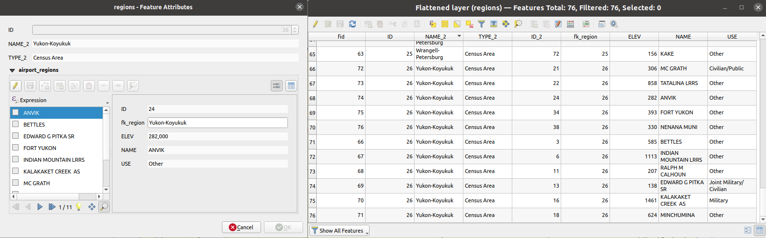
图 27.47 Form of a region with related children (left) - A duplicate region feature for each related child, with joined attributes (right)
参数
标注 |
名称 |
类型 |
描述 |
|---|---|---|---|
Input Layer |
|
[vector: any] |
Layer with the relationship that should be de-normalized |
Flattened Layer 可选 |
|
[same as input] Default: |
Specify the output (flattened) layer. One of:
文件编码也可以在此更改。 |
输出
标注 |
名称 |
类型 |
描述 |
|---|---|---|---|
Flattened layer |
|
[same as input] |
A layer containing master features with all the attributes for the related features |
Python代码
Algorithm ID: native:flattenrelationships
import processing
processing.run("algorithm_id", {parameter_dictionary})
当你在数据处理工具箱某个算法前悬停时,算法 id 将会展现。*参数字*将会提供参数的名称与数值。参考详见`数据处理_控制台`以获取如何从Python控制台中运行数据处理算法。
27.1.17.18. Join attributes by field value
Takes an input vector layer and creates a new vector layer that is an extended version of the input one, with additional attributes in its attribute table.
The additional attributes and their values are taken from a second vector layer. An attribute is selected in each of them to define the join criteria.
参数
标注 |
名称 |
类型 |
描述 |
|---|---|---|---|
Input Layer |
|
[vector: any] |
Input vector layer. The output layer will consist of the features of this layer with attributes from matching features in the second layer. |
Table field |
|
[tablefield: any] |
Field of the source layer to use for the join |
Input layer 2 |
|
[vector: any] |
Layer with the attribute table to join |
Table field 2 |
|
[tablefield: any] |
Field of the second (join) layer to use for the join The type of the field must be equal to (or compatible with) the input table field type. |
Layer 2 fields to copy 可选 |
|
[tablefield: any] [list] |
Select the specific fields you want to add. By default all the fields are added. |
Join type |
|
[enumeration] Default: 1 |
The type of the final joined layer. One of:
|
Discard records which could not be joined |
|
[boolean] Default: True |
Check if you don't want to keep the features that could not be joined |
Joined field prefix 可选 |
|
[string] |
Add a prefix to joined fields in order to easily identify them and avoid field name collision |
Joined layer 可选 |
|
[same as input] Default: |
Specify the output vector layer for the join. One of:
文件编码也可以在此更改。 |
Unjoinable features from first layer 可选 |
|
[same as input] Default: |
Specify the output vector layer for unjoinable features from first layer. One of:
文件编码也可以在此更改。 |
输出
标注 |
名称 |
类型 |
描述 |
|---|---|---|---|
Number of joined features from input table |
|
[数字] |
|
Unjoinable features from first layer 可选 |
|
[same as input] |
Vector layer with the non-matched features |
Joined layer 可选 |
|
[same as input] |
Output vector layer with added attributes from the join |
Number of unjoinable features from input table 可选 |
|
[数字] |
Python代码
Algorithm ID: native:joinattributestable
import processing
processing.run("algorithm_id", {parameter_dictionary})
当你在数据处理工具箱某个算法前悬停时,算法 id 将会展现。*参数字*将会提供参数的名称与数值。参考详见`数据处理_控制台`以获取如何从Python控制台中运行数据处理算法。
27.1.17.19. Join attributes by location
Takes an input vector layer and creates a new vector layer that is an extended version of the input one, with additional attributes in its attribute table.
The additional attributes and their values are taken from a second vector layer. A spatial criteria is applied to select the values from the second layer that are added to each feature from the first layer.
Default menu:
参见
Join attributes by nearest, Join attributes by field value, Join attributes by location (summary)
Exploring spatial relations
Geometric predicates are boolean functions used to determine the spatial relation a feature has with another by comparing whether and how their geometries share a portion of space.
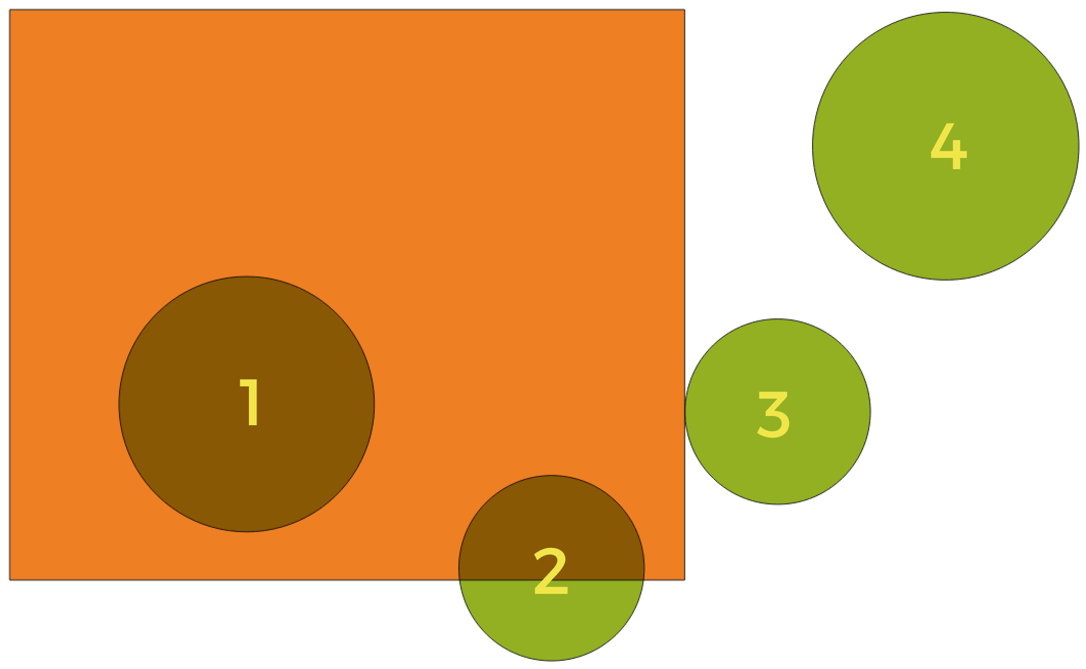
图 27.48 Looking for spatial relations between layers
Using the figure above, we are looking for the green circles by spatially comparing them to the orange rectangle feature. Available geometric predicates are:
- Intersect
Tests whether a geometry intersects another. Returns 1 (true) if the geometries spatially intersect (share any portion of space - overlap or touch) and 0 if they don’t. In the picture above, this will return circles 1, 2 and 3.
- Contain
Returns 1 (true) if and only if no points of b lie in the exterior of a, and at least one point of the interior of b lies in the interior of a. In the picture, no circle is returned, but the rectangle would be if you would look for it the other way around, as it contains circle 1 completely. This is the opposite of are within.
- Disjoint
Returns 1 (true) if the geometries do not share any portion of space (no overlap, not touching). Only circle 4 is returned.
- Equal
Returns 1 (true) if and only if geometries are exactly the same. No circles will be returned.
- Touch
Tests whether a geometry touches another. Returns 1 (true) if the geometries have at least one point in common, but their interiors do not intersect. Only circle 3 is returned.
- Overlap
Tests whether a geometry overlaps another. Returns 1 (true) if the geometries share space, are of the same dimension, but are not completely contained by each other. Only circle 2 is returned.
- Are within
Tests whether a geometry is within another. Returns 1 (true) if geometry a is completely inside geometry b. Only circle 1 is returned.
- Cross
Returns 1 (true) if the supplied geometries have some, but not all, interior points in common and the actual crossing is of a lower dimension than the highest supplied geometry. For example, a line crossing a polygon will cross as a line (true). Two lines crossing will cross as a point (true). Two polygons cross as a polygon (false). In the picture, no circles will be returned.
参数
标注 |
名称 |
类型 |
描述 |
|---|---|---|---|
Join to features in |
|
[vector: any] |
Input vector layer. The output layer will consist of the features of this layer with attributes from matching features in the second layer. |
Where the features |
|
[enumeration] [list] Default: [0] |
Type of spatial relation the source feature should have with the target feature so that they could be joined. One or more of:
If more than one condition is chosen, at least one of them (OR operation) has to be met for a feature to be extracted. |
By comparing to |
|
[vector: any] |
The join layer. Features of this vector layer will add their attributes to the source layer attribute table if they satisfy the spatial relationship. |
Fields to add (leave empty to use all fields) 可选 |
|
[tablefield: any] [list] |
Select the specific fields you want to add from the join layer. By default all the fields are added. |
Join type |
|
[enumeration] |
The type of the final joined layer. One of:
|
Discard records which could not be joined |
|
[boolean] Default: False |
Remove from the output the input layer's features which could not be joined |
Joined field prefix 可选 |
|
[string] |
Add a prefix to joined fields in order to easily identify them and avoid field name collision |
Joined layer 可选 |
|
[same as input] Default: |
Specify the output vector layer for the join. One of:
文件编码也可以在此更改。 |
Unjoinable features from first layer 可选 |
|
[same as input] Default: |
Specify the output vector layer for unjoinable features from first layer. One of:
文件编码也可以在此更改。 |
输出
标注 |
名称 |
类型 |
描述 |
|---|---|---|---|
Number of joined features from input table |
|
[数字] |
|
Unjoinable features from first layer 可选 |
|
[same as input] |
Vector layer of the non-matched features |
Joined layer |
|
[same as input] |
Output vector layer with added attributes from the join |
Python代码
Algorithm ID: native:joinattributesbylocation
import processing
processing.run("algorithm_id", {parameter_dictionary})
当你在数据处理工具箱某个算法前悬停时,算法 id 将会展现。*参数字*将会提供参数的名称与数值。参考详见`数据处理_控制台`以获取如何从Python控制台中运行数据处理算法。
27.1.17.20. Join attributes by location (summary)
Takes an input vector layer and creates a new vector layer that is an extended version of the input one, with additional attributes in its attribute table.
The additional attributes and their values are taken from a second vector layer. A spatial criteria is applied to select the values from the second layer that are added to each feature from the first layer.
The algorithm calculates a statistical summary for the values from matching features in the second layer (e.g. maximum value, mean value, etc).
Exploring spatial relations
Geometric predicates are boolean functions used to determine the spatial relation a feature has with another by comparing whether and how their geometries share a portion of space.
图 27.49 Looking for spatial relations between layers
Using the figure above, we are looking for the green circles by spatially comparing them to the orange rectangle feature. Available geometric predicates are:
- Intersect
Tests whether a geometry intersects another. Returns 1 (true) if the geometries spatially intersect (share any portion of space - overlap or touch) and 0 if they don’t. In the picture above, this will return circles 1, 2 and 3.
- Contain
Returns 1 (true) if and only if no points of b lie in the exterior of a, and at least one point of the interior of b lies in the interior of a. In the picture, no circle is returned, but the rectangle would be if you would look for it the other way around, as it contains circle 1 completely. This is the opposite of are within.
- Disjoint
Returns 1 (true) if the geometries do not share any portion of space (no overlap, not touching). Only circle 4 is returned.
- Equal
Returns 1 (true) if and only if geometries are exactly the same. No circles will be returned.
- Touch
Tests whether a geometry touches another. Returns 1 (true) if the geometries have at least one point in common, but their interiors do not intersect. Only circle 3 is returned.
- Overlap
Tests whether a geometry overlaps another. Returns 1 (true) if the geometries share space, are of the same dimension, but are not completely contained by each other. Only circle 2 is returned.
- Are within
Tests whether a geometry is within another. Returns 1 (true) if geometry a is completely inside geometry b. Only circle 1 is returned.
- Cross
Returns 1 (true) if the supplied geometries have some, but not all, interior points in common and the actual crossing is of a lower dimension than the highest supplied geometry. For example, a line crossing a polygon will cross as a line (true). Two lines crossing will cross as a point (true). Two polygons cross as a polygon (false). In the picture, no circles will be returned.
参数
标注 |
名称 |
类型 |
描述 |
|---|---|---|---|
Join to features in |
|
[vector: any] |
Input vector layer. The output layer will consist of the features of this layer with attributes from matching features in the second layer. |
Where the features |
|
[enumeration] [list] Default: [0] |
Type of spatial relation the source feature should have with the target feature so that they could be joined. One or more of:
If more than one condition is chosen, at least one of them (OR operation) has to be met for a feature to be extracted. |
By comparing to |
|
[vector: any] |
The join layer. Features of this vector layer will add summaries of their attributes to the source layer attribute table if they satisfy the spatial relationship. |
Fields to summarize (leave empty to use all fields) 可选 |
|
[tablefield: any] [list] |
Select the specific fields you want to add from the join layer. By default all the fields are added. |
Summaries to calculate (leave empty to use all fields) 可选 |
|
[enumeration] [list] Default: [] |
For each input feature, statistics are calculated on joined fields of their matching features. One or more of:
|
Discard records which could not be joined |
|
[boolean] Default: False |
Remove from the output the input layer's features which could not be joined |
Joined layer |
|
[same as input] Default: |
Specify the output vector layer for the join. One of:
文件编码也可以在此更改。 |
输出
标注 |
名称 |
类型 |
描述 |
|---|---|---|---|
Joined layer |
|
[same as input] |
Output vector layer with summarized attributes from the join |
Python代码
Algorithm ID: qgis:joinbylocationsummary
import processing
processing.run("algorithm_id", {parameter_dictionary})
当你在数据处理工具箱某个算法前悬停时,算法 id 将会展现。*参数字*将会提供参数的名称与数值。参考详见`数据处理_控制台`以获取如何从Python控制台中运行数据处理算法。
27.1.17.21. Join attributes by nearest
Takes an input vector layer and creates a new vector layer with additional fields in its attribute table. The additional attributes and their values are taken from a second vector layer. Features are joined by finding the closest features from each layer.
By default only the nearest feature is joined, but the join can also join to the k-nearest neighboring features.
If a maximum distance is specified, only features which are closer than this distance will be matched.
参见
Nearest neighbour analysis, Join attributes by field value, Join attributes by location, Distance matrix
参数
标注 |
名称 |
类型 |
描述 |
|---|---|---|---|
输入图层 |
|
[vector: any] |
The input layer. |
Input layer 2 |
|
[vector: any] |
The join layer. |
Layer 2 fields to copy (leave empty to copy all fields) |
|
[fields] |
Join layer fields to copy (if empty, all fields will be copied). |
Discard records which could not be joined |
|
[boolean] Default: False |
Remove from the output the input layer records which could not be joined |
Joined field prefix |
|
[string] |
Joined field prefix |
Maximum nearest neighbors |
|
[数字] Default: 1 |
Maximum number of nearest neighbors |
Maximum distance |
|
[数字] |
Maximum search distance |
Joined layer 可选 |
|
[same as input] Default: |
Specify the vector layer containing the joined features. One of:
文件编码也可以在此更改。 |
Unjoinable features from first layer |
|
[same as input] Default: |
Specify the vector layer containing the features that could not be joined. One of:
文件编码也可以在此更改。 |
输出
标注 |
名称 |
类型 |
描述 |
|---|---|---|---|
Joined layer |
|
[same as input] |
The output joined layer. |
Unjoinable features from first layer |
|
[same as input] |
Layer containing the features from first layer that could not be joined to any features in the join layer. |
Number of joined features from input table |
|
[数字] |
Number of features from the input table that have been joined. |
Number of unjoinable features from input table |
|
[数字] |
Number of features from the input table that could not be joined. |
Python代码
Algorithm ID: native:joinbynearest
import processing
processing.run("algorithm_id", {parameter_dictionary})
当你在数据处理工具箱某个算法前悬停时,算法 id 将会展现。*参数字*将会提供参数的名称与数值。参考详见`数据处理_控制台`以获取如何从Python控制台中运行数据处理算法。
27.1.17.22. Merge vector layers
Combines multiple vector layers of the same geometry type into a single one.
The attribute table of the resulting layer will contain the fields from all input layers. If fields with the same name but different types are found then the exported field will be automatically converted into a string type field. New fields storing the original layer name and source are also added.
If any input layers contain Z or M values, then the output layer will also contain these values. Similarly, if any of the input layers are multi-part, the output layer will also be a multi-part layer.
Optionally, the destination coordinate reference system (CRS) for the merged layer can be set. If it is not set, the CRS will be taken from the first input layer. All layers will be reprojected to match this CRS.
Default menu:
参数
标注 |
名称 |
类型 |
描述 |
|---|---|---|---|
Input Layers |
|
[vector: any] [list] |
The layers that are to be merged into a single layer. Layers should be of the same geometry type. |
Destination CRS 可选 |
|
[crs] |
Choose the CRS for the output layer. If not specified, the CRS of the first input layer is used. |
Merged |
|
[same as input] Default: |
Specify the output vector layer. One of:
文件编码也可以在此更改。 |
输出
标注 |
名称 |
类型 |
描述 |
|---|---|---|---|
Merged |
|
[same as input] |
Output vector layer containing all the features and attributes from the input layers. |
Python代码
Algorithm ID: native:mergevectorlayers
import processing
processing.run("algorithm_id", {parameter_dictionary})
当你在数据处理工具箱某个算法前悬停时,算法 id 将会展现。*参数字*将会提供参数的名称与数值。参考详见`数据处理_控制台`以获取如何从Python控制台中运行数据处理算法。
27.1.17.23. Order by expression
Sorts a vector layer according to an expression: changes the feature index according to an expression.
Be careful, it might not work as expected with some providers, the order might not be kept every time.
参数
标注 |
名称 |
类型 |
描述 |
|---|---|---|---|
Input Layer |
|
[vector: any] |
Input vector layer to sort |
Expression |
|
[expression] |
Expression to use for the sorting |
Sort ascending |
|
[boolean] Default: True |
If checked the vector layer will be sorted from small to large values. |
Sort nulls first |
|
[boolean] Default: False |
If checked, Null values are placed first |
Ordered |
|
[same as input] Default: |
Specify the output vector layer. One of:
文件编码也可以在此更改。 |
输出
标注 |
名称 |
类型 |
描述 |
|---|---|---|---|
Ordered |
|
[same as input] |
Output (sorted) vector layer |
Python代码
Algorithm ID: native:orderbyexpression
import processing
processing.run("algorithm_id", {parameter_dictionary})
当你在数据处理工具箱某个算法前悬停时,算法 id 将会展现。*参数字*将会提供参数的名称与数值。参考详见`数据处理_控制台`以获取如何从Python控制台中运行数据处理算法。
27.1.17.24. Repair Shapefile
Repairs a broken ESRI Shapefile dataset by (re)creating the SHX file.
参数
标注 |
名称 |
类型 |
描述 |
|---|---|---|---|
Input Shapefile |
|
[file] |
Full path to the ESRI Shapefile dataset with a missing or broken SHX file |
输出
标注 |
名称 |
类型 |
描述 |
|---|---|---|---|
Repaired layer |
|
[vector: any] |
The input vector layer with the SHX file repaired |
Python代码
Algorithm ID: native:repairshapefile
import processing
processing.run("algorithm_id", {parameter_dictionary})
当你在数据处理工具箱某个算法前悬停时,算法 id 将会展现。*参数字*将会提供参数的名称与数值。参考详见`数据处理_控制台`以获取如何从Python控制台中运行数据处理算法。
27.1.17.25. Reproject layer
Reprojects a vector layer in a different CRS. The reprojected layer will have the same features and attributes of the input layer.
Allows features in-place modification
of point, line, and polygon features
参数
Basic parameters
标注 |
名称 |
类型 |
描述 |
|---|---|---|---|
Input Layer |
|
[vector: any] |
Input vector layer to reproject |
Target CRS |
|
[crs] Default: |
Destination coordinate reference system |
Reprojected |
|
[same as input] Default: |
Specify the output vector layer. One of:
文件编码也可以在此更改。 |
Advanced parameters
标注 |
名称 |
类型 |
描述 |
|---|---|---|---|
Coordinate Operation 可选 |
|
[string] |
Specific operation to use for a particular reprojection task, instead of always forcing use of the current project's transformation settings. Useful when reprojecting a particular layer and control over the exact transformation pipeline is required. Requires proj version >= 6. Read more at Datum Transformations. |
输出
标注 |
名称 |
类型 |
描述 |
|---|---|---|---|
Reprojected |
|
[same as input] |
Output (reprojected) vector layer |
Python代码
Algorithm ID: native:reprojectlayer
import processing
processing.run("algorithm_id", {parameter_dictionary})
当你在数据处理工具箱某个算法前悬停时,算法 id 将会展现。*参数字*将会提供参数的名称与数值。参考详见`数据处理_控制台`以获取如何从Python控制台中运行数据处理算法。
27.1.17.26. Save vector features to file
Saves vector features to a specified file dataset.
For dataset formats supporting layers, an optional layer name parameter can be used to specify a custom string. Optional GDAL-defined dataset and layer options can be specified. For more information on this, read the online GDAL documentation on the format.
参数
Basic parameters
标注 |
名称 |
类型 |
描述 |
|---|---|---|---|
Vector features |
|
[vector: any] |
Input vector layer. |
Saved features |
|
[same as input] 默认: |
Specify the file to save the features to. One of:
|
Advanced parameters
标注 |
名称 |
类型 |
描述 |
|---|---|---|---|
Layer name 可选 |
|
[string] |
Name to use for the output layer |
GDAL dataset options 可选 |
|
[string] |
GDAL dataset creation options of the output format. Separate individual options with semicolons. |
GDAL layer options 可选 |
|
[string] |
GDAL layer creation options of the output format. Separate individual options with semicolons. |
输出
标注 |
名称 |
类型 |
描述 |
|---|---|---|---|
Saved features |
|
[same as input] |
Vector layer with the saved features. |
File name and path |
|
[string] |
Output file name and path. |
Layer name |
|
[string] |
Name of the layer, if any. |
Python代码
Algorithm ID: native:savefeatures
import processing
processing.run("algorithm_id", {parameter_dictionary})
当你在数据处理工具箱某个算法前悬停时,算法 id 将会展现。*参数字*将会提供参数的名称与数值。参考详见`数据处理_控制台`以获取如何从Python控制台中运行数据处理算法。
27.1.17.27. Set layer encoding
Sets the encoding used for reading a layer's attributes. No permanent changes are made to the layer, rather it affects only how the layer is read during the current session.
备注
Changing the encoding is only supported for some vector layer data sources.
参数
标注 |
名称 |
类型 |
描述 |
|---|---|---|---|
Saved features |
|
[vector: any] |
Vector layer to set the encoding. |
Encoding |
|
[string] |
Text encoding to assign to the layer in the current QGIS session. |
输出
标注 |
名称 |
类型 |
描述 |
|---|---|---|---|
Output layer |
|
[same as input] |
Input vector layer with the set encoding. |
Python代码
Algorithm ID: native:setlayerencoding
import processing
processing.run("algorithm_id", {parameter_dictionary})
当你在数据处理工具箱某个算法前悬停时,算法 id 将会展现。*参数字*将会提供参数的名称与数值。参考详见`数据处理_控制台`以获取如何从Python控制台中运行数据处理算法。
27.1.17.28. Split features by character
Features are split into multiple output features by splitting a field's value at a specified character. For instance, if a layer contains features with multiple comma separated values contained in a single field, this algorithm can be used to split these values up across multiple output features. Geometries and other attributes remain unchanged in the output. Optionally, the separator string can be a regular expression for added flexibility.
Allows
features in-place modification
of point, line, and polygon features
参数
标注 |
名称 |
类型 |
描述 |
|---|---|---|---|
Input Layer |
|
[vector: any] |
Input vector layer |
Split using values in the field |
|
[tablefield: any] |
Field to use for splitting |
Split value using character |
|
[string] |
Character to use for splitting |
Use regular expression separator |
|
[boolean] Default: False |
|
Split |
|
[same as input] Default: |
Specify output vector layer. One of:
文件编码也可以在此更改。 |
输出
标注 |
名称 |
类型 |
描述 |
|---|---|---|---|
Split |
|
[same as input] |
The output vector layer. |
Python代码
Algorithm ID: native:splitfeaturesbycharacter
import processing
processing.run("algorithm_id", {parameter_dictionary})
当你在数据处理工具箱某个算法前悬停时,算法 id 将会展现。*参数字*将会提供参数的名称与数值。参考详见`数据处理_控制台`以获取如何从Python控制台中运行数据处理算法。
27.1.17.29. Split vector layer
Creates a set of vectors in an output folder based on an input layer and an attribute. The output folder will contain as many layers as the unique values found in the desired field.
The number of files generated is equal to the number of different values found for the specified attribute.
It is the opposite operation of merging.
Default menu:
参数
Basic parameters
标注 |
名称 |
类型 |
描述 |
|---|---|---|---|
Input Layer |
|
[vector: any] |
Input vector layer |
Unique ID field |
|
[tablefield: any] |
Field to use for splitting |
Output directory |
|
[folder] Default: |
Specify the directory for the output layers. One of:
|
Advanced parameters
标注 |
名称 |
类型 |
描述 |
|---|---|---|---|
Output file type 可选 |
|
[enumeration] Default: |
Select the extension of the output files. If not specified or invalid, the output files format will be the one set in the "Default output vector layer extension" Processing setting. |
输出
标注 |
名称 |
类型 |
描述 |
|---|---|---|---|
Output directory |
|
[folder] |
The directory for the output layers |
Output layers |
|
[same as input] [list] |
The output vector layers resulting from the split. |
Python代码
Algorithm ID: native:splitvectorlayer
import processing
processing.run("algorithm_id", {parameter_dictionary})
当你在数据处理工具箱某个算法前悬停时,算法 id 将会展现。*参数字*将会提供参数的名称与数值。参考详见`数据处理_控制台`以获取如何从Python控制台中运行数据处理算法。
27.1.17.30. Truncate table
Truncates a layer, by deleting all features from within the layer.
警告
This algorithm modifies the layer in place, and deleted features cannot be restored!
参数
标注 |
名称 |
类型 |
描述 |
|---|---|---|---|
Input Layer |
|
[vector: any] |
Input vector layer |
输出
标注 |
名称 |
类型 |
描述 |
|---|---|---|---|
Truncated layer |
|
[folder] |
The truncated (empty) layer |
Python代码
Algorithm ID: native:truncatetable
import processing
processing.run("algorithm_id", {parameter_dictionary})
当你在数据处理工具箱某个算法前悬停时,算法 id 将会展现。*参数字*将会提供参数的名称与数值。参考详见`数据处理_控制台`以获取如何从Python控制台中运行数据处理算法。