` `
Plug-in Coördinaat klikken
De plug-in Coödinaat klikken is eenvoudig te gebruiken en verschaft de mogelijkheid om coördinaten weer tegeven in het kaartvenster voor twee geselecteerde coördinaten referentie systemen (CRS).
Plug-in Coördinaat klikken
- Start QGIS, select
 Project Properties from the
Settings (KDE, Windows) or File (Gnome, macOS) menu
and click on the Projection tab. As an alternative, you can also
click on the
Project Properties from the
Settings (KDE, Windows) or File (Gnome, macOS) menu
and click on the Projection tab. As an alternative, you can also
click on the  CRS status icon in the lower
right-hand corner of the status bar.
CRS status icon in the lower
right-hand corner of the status bar. Klik op het keuzevak
 Gelijktijdige CRS-transformatie gebruiken en selecteer een geprojecteerd coördinatensysteem van uw keuze (zie ook Werken met projecties).
- Activate the coordinate capture plugin in the Plugin Manager (see
Het dialoogvenster Plug-ins) and ensure that the dialog is visible by going to
View ‣ Panels and ensuring that
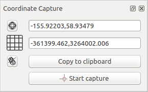
Coordinate Capture is enabled. The coordinate capture dialog
appears as shown in Figure figure_coordinate_capture. Alternatively,
you can also go to Vector ‣ Coordinate Capture and see
if Coordinate Capture is enabled.
Klik op het pictogram
 Klik om het CRS te selecteren voor het tonen van de coördinaten en selecteer een ander CRS dan dat welke u hierboven selecteerde.
- To start capturing coordinates, click on [Start capture]. You can now click anywhere on the map canvas and the plugin will show the coordinates for both of your selected CRS.
Klik op het pictogram
 Muis volgen om het traceren van coördinaten met de muis in te schakelen.
U kunt de geselecteerde coördinaten ook kopiëren naar het klembord.