` `
Práce s projekcemi
QGIS umožňuje uživatelům definovat globální a projektový CRS (souřadnicový referenční systém) pro vrstvy bez předem definovaného CRS. Umožňuje také uživateli definovat vlastní souřadnicové referenční systémy a podporuje projekci vektorových a rastrových vrstev on-the-fly (OTF). Všechny tyto funkce umožňují uživateli zobrazit vrstvy s různými CRS a nechat je správně překrýt.
Přehled projekční podpory
QGIS podporuje zhruba 2 700 známých souřadnicových systémů. Definice pro každý CRS jsou uloženy v databázi SQLite, která je nainstalována s QGIS. Běžný uživatel nemusí přímo manipulovat s databází, to může způsobit selhání projekční podpory. Vlastní CRS jsou uloženy v uživatelské databázi. Viz část: ref: `sec_custom_projections ‘pro informace o správě vašich vlastních souřadnicových referenčních systémů.
Systémy CRS, které jsou k dispozici v systému QGIS, jsou založeny na definicích definovaných Evropskou skupinou pro vyhledávání ropy (EPSG) (Dnes již pod zkratkou EPSG rozumíme Geodetic Parameter Set) a na Národním Institutu Francouzské Geografie (IGNF) a jsou z velké části odvozeny z prostorových referenčních tabulek používaných v GDAL. Identifikátory EPSG jsou v databázi a lze je použít k zadání CRS v QGIS.
In order to use OTF projection, either your data must contain information about its coordinate reference system or you will need to define a global, layer or project-wide CRS. For PostGIS layers, QGIS uses the spatial reference identifier that was specified when the layer was created. For data supported by OGR, QGIS relies on the presence of a recognized means of specifying the CRS. In the case of shapefiles, this means a file containing the well-known text (WKT) specification of the CRS. This projection file has the same base name as the shapefile and a .prj extension. For example, a shapefile named alaska.shp would have a corresponding projection file named alaska.prj.
Whenever you select a new CRS, the layer units will automatically be
changed in the General tab of the  Project Properties dialog under the Project
(or
Project Properties dialog under the Project
(or  Settings) menu.
Specifikace světových projekcí
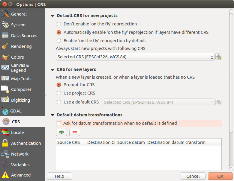
QGIS starts each new project using the global default projection. The global
default CRS is EPSG:4326 - WGS 84 (proj=longlat +ellps=WGS84 +datum=WGS84 +no_defs),
and it comes predefined in QGIS. This default can be changed via the  Select CRS button in the first section, which is used to define the default
coordinate reference system for new projects, as shown in
figure_projection_options. This choice will be saved for use in subsequent QGIS
sessions.
Select CRS button in the first section, which is used to define the default
coordinate reference system for new projects, as shown in
figure_projection_options. This choice will be saved for use in subsequent QGIS
sessions.
Záložka CRS v dialogu nastavení QGIS
Při používání vrstev, které nemají CRS, je třeba definovat, jak QGIS reaguje na tyto vrstvy. Toto lze provést globálně nebo v rámci projektu na CRS záložka Settings ‣ Options.
The options shown in figure_projection_options are:
 :guilabel:` CRS na dotaz `
 Použít CRS projektu
- Použít výchozí CRS zobrazený níže
If you want to define the coordinate reference system for a certain layer without CRS information, you can also do that in the General tab of the raster and vector properties dialog (see General Properties for rasters and General Properties for vectors). If your layer already has a CRS defined, it will be displayed as shown in General tab in vector layers properties dialog.
Tip
CRS in the Layers Panel
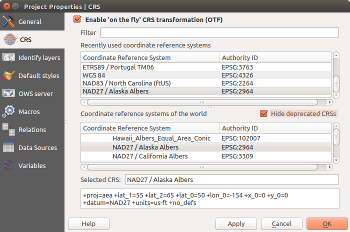
Right-clicking on a layer in the Layers Panel (section Layers Panel) provides two CRS shortcuts. Set layer CRS takes you directly to the Coordinate Reference System Selector dialog (see figure_projection_project). Set project CRS from Layer redefines the project CRS using the layer’s CRS.
Define On The Fly (OTF) CRS Transformation
QGIS supports on the fly CRS transformation for both raster and vector data. However, OTF is not activated by default. When OTF is off, each layer is drawn using the coordinates as read from the data source. When OTF is on, each layer’s coordinates are transformed to the CRS of the project.
There are three ways to enable On The Fly CRS Transformation:
- Select
 Project Properties ‣ CRS from
the Project ( or Settings) menu. You
can then activate the
Project Properties ‣ CRS from
the Project ( or Settings) menu. You
can then activate the  Enable on the fly CRS
transformation (OTF) checkbox in the
Enable on the fly CRS
transformation (OTF) checkbox in the  CRS tab and select
the CRS to use (see Coordinate Reference System Selector)
CRS tab and select
the CRS to use (see Coordinate Reference System Selector) - Click on the
 CRS status icon in the lower right-hand
corner of the status bar, leading you to the previous dialog.
CRS status icon in the lower right-hand
corner of the status bar, leading you to the previous dialog. - Turn OTF on by default in the CRS tab of the
Settings ‣ Options dialog by selecting
Enable ‘on the fly’ reprojection by default or
Automatically enable ‘on the fly’ reprojection if layers have
different CRS.
If you have already loaded a layer and you want to enable OTF reprojection, the
best practice is to open the CRS tab of the Project
Properties dialog, activate the Enable ‘on the fly’
CRS transformation checkbox, and select a CRS.
The CRS status icon will no longer be greyed out, and all
layers will be OTF projected to the CRS shown next to the icon.
Dialog vlastností projektu
Coordinate Reference System Selector
This dialog helps you assign a Coordinate Reference System to a project or a layer, provided a set of projection databases. Items in the dialog are:
- Filter: If you know the EPSG code, the identifier, or the name for a coordinate reference system, you can use the search feature to find it. Enter the EPSG code, the identifier or the name.
- Recently used coordinate reference systems: If you have certain CRSs that you frequently use in your everyday GIS work, these will be displayed in this list. Click on one of these items to select the associated CRS.
- Coordinate reference systems of the world: This is a list of all CRSs supported by QGIS, including Geographic, Projected and Custom coordinate reference systems. To define a CRS, select it from the list by expanding the appropriate node and selecting the CRS. The active CRS is preselected.
- PROJ.4 text: This is the CRS string used by the PROJ.4 projection engine. This text is read-only and provided for informational purposes.
Tip
Looking for a layer CRS? Use the CRS selector.
Sometimes, you receive a layer and you don’t know its projection. Assuming that you have another layer with a valid crs that should overlaps with it, enable the OTF reprojection and, in the General tab of the Layer properties dialog, use the Coordinate Reference System selector to assign a projection. Your layer position is then moved accordingly. You may have to do some trial and error in order to find the right position, hence its original CRS.
Poznámka
When operating across layers, for example, computing intersections between two layers, it is important that both layers have the same CRS. To change the projection of an existing layer, it is insufficient to simply change the CRS in that layer’s properties. Instead you must save the layer as a new layer, and choose the desired CRS for the new layer.
Vlastní souřadnicový referenční systém
Pokud QGIS neposkytuje souřadnicový referenční systém, který potřebujete, můžete definovat vlastní CRS. Chcete-li definovat CRS, zvolte  vlastní CRS... z menu Nastavení. Vlastní uživatelské systémy jsou uloženy ve vaší vlastní uživatelské QGIS databázi. Kromě vašich CRS obsahuje tato databáze vaše prostorové záložky a další vlastní data.
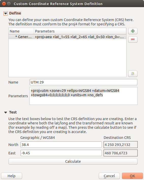
Dialog vlastní CRS
Definování vlastních CRS v QGIS vyžaduje dobrou znalost projekční knihovny PROJ.4. Pro začátek vás odkazujeme na “Cartographic Projection Procedures for the UNIX Environment - A User’s Manual” od Gerald I. Evenden, U.S. Geological Survey Open-File Report 90-284, 1990 (dostupné na ftp://ftp.remotesensing.org/proj/OF90-284.pdf).
Tato příručka popisuje použití nástrojů proj.4``a souvisejících nástrojů příkazové řádky. Kartografické parametry používané s ``proj.4 jsou popsány v uživatelské příručce a jsou stejné jako u QGIS.
Dialog Vlastní definice souřadnicového referenčního systému vyžaduje pouze dva parametry pro definování uživatelského SRS:
Popisný název
Kartografické parametry ve formátu PROJ.4
Chcete-li vytvořit nový CRS, klikněte na tlačítko  :sup:`Přidat nový CRS`a zadejte popisný název a parametry CRS.
Pamatujte, že Parametry musí začínat na blok +proj=, který reprezentuje nový souřadnicový referenční systém.
You can test your CRS parameters to see if they give sane results. To do this, enter known WGS 84 latitude and longitude values in North and East fields, respectively. Click on [Calculate], and compare the results with the known values in your coordinate reference system.
Defaultní transformace
OTF depends on being able to transform data into a ‘default CRS’, and QGIS uses WGS84. For some CRS there are a number of transforms available. QGIS allows you to define the transformation used otherwise QGIS uses a default transformation.
In the CRS tab under Settings ‣
Options you can:
- set QGIS to ask you when it needs define a transformation using
Ask for datum transformation when no default is defined
- edit a list of user defaults for transformations.
QGIS asks which transformation to use by opening a dialogue box
displaying PROJ.4 text describing the source and destination
transforms. Further information may be found by hovering over a
transform. User defaults can be saved by selecting
Remember selection.