Fontos
A fordítás közösségi munka, amihez itt tud csatlakozni. Ennek az oldalnak eddig 50.67%-a van lefordítva.
24.1.21. Raster tools
24.1.21.1. Align raster
Aligns raster by resampling it to the same cell size and reprojecting to the same CRS as a reference raster.
Figyelem
This algorithm is ONLY available in the Model Designer context. For other contexts, use instead Align rasters.
Paraméterek
Címke |
Név |
Típus |
Leírás |
|---|---|---|---|
Bemeneti réteg |
|
[raster] |
Input raster layer to align |
Resampling method |
|
[felsorolás] Alapértelmezett: 0 |
A bemeneti réteg újramintavételezéséhez használt módszer.
|
Rescale values according to the cell size |
|
[logikai] Default: No |
|
Reference layer |
|
[raster] |
A raster layer that will be used to fetch extent, cell size and CRS that will be applied to input layers. |
Override reference CRS Optional |
|
[crs] |
CRS to be used instead of the reference layer’s |
Override reference cell size X Optional |
|
[numerikus: double] |
Cell size in X direction to be used instead of the reference layer’s |
Override reference cell size Y Optional |
|
[numerikus: double] |
Cell size in Y direction to be used instead of the reference layer’s |
Override reference grid offset X Optional |
|
[numerikus: double] |
Offset in X direction to apply to cells grid |
Override reference grid offset Y Optional |
|
[numerikus: double] |
Offset in Y direction to apply to cells grid |
Clip to extent Optional |
|
[terjedelem] |
Specify the extent of the output raster layer. It will internally be extended to a multiple of the tile size. A rendelkezésre álló módszerek a következők:
|
Aligned raster |
|
[raster] |
output raster with pixels resampled |
Kimenetek
Címke |
Név |
Típus |
Leírás |
|---|---|---|---|
Aligned raster |
|
[raster] |
output raster with pixels resampled |
Python kód
Algorithm ID: native:alignsingleraster
import processing
processing.run("algorithm_id", {parameter_dictionary})
Az algoritmus azonosító akkor jelenik meg, ha az egérmutatót az algoritmus fölé viszi a Feldolgozás eszköztáron. A paraméterszótár tartalmazza a paraméter NAME-eket és érékeket. A feldolgozási algoritmusok Python konzolról történő futtatásával kapcsolatos részletekért lásd a Using processing algorithms from the console fejezetet.
24.1.21.2. Align rasters
Aligns rasters by resampling them to the same cell size and reprojecting to the same CRS as a reference raster.
Figyelem
This algorithm is NOT available in the Model Designer context. Use instead Align raster.
Paraméterek
Címke |
Név |
Típus |
Leírás |
|---|---|---|---|
Bemeneti rétegek |
|
[raster] [list] |
List of input raster layers with resampling options associated
(filled as a
Rescale values according to the cell size [boolean] ( |
Reference layer |
|
[raster] |
A raster layer that will be used to fetch extent, cell size and CRS that will be applied to input layers. |
Override reference CRS Optional |
|
[crs] |
CRS to be used instead of the reference layer’s |
Override reference cell size X Optional |
|
[numerikus: double] |
Cell size in X direction to be used instead of the reference layer’s |
Override reference cell size Y Optional |
|
[numerikus: double] |
Cell size in Y direction to be used instead of the reference layer’s |
Override reference grid offset X Optional |
|
[numerikus: double] |
Offset in X direction to apply to cells grid |
Override reference grid offset Y Optional |
|
[numerikus: double] |
Offset in Y direction to apply to cells grid |
Clip to extent Optional |
|
[terjedelem] |
Specify the extent of the output raster layer. It will internally be extended to a multiple of the tile size. A rendelkezésre álló módszerek a következők:
|
Kimenetek
Címke |
Név |
Típus |
Leírás |
|---|---|---|---|
Aligned rasters |
|
[raster] [list] |
output rasters with pixels resampled |
Python kód
Algorithm ID: native:alignrasters
import processing
processing.run("algorithm_id", {parameter_dictionary})
Az algoritmus azonosító akkor jelenik meg, ha az egérmutatót az algoritmus fölé viszi a Feldolgozás eszköztáron. A paraméterszótár tartalmazza a paraméter NAME-eket és érékeket. A feldolgozási algoritmusok Python konzolról történő futtatásával kapcsolatos részletekért lásd a Using processing algorithms from the console fejezetet.
24.1.21.3. Convert map to raster
Creates a raster image of map canvas content.
A map theme can be selected to render a predetermined set of layers with a defined style for each layer.
Alternatively, a single layer can be selected if no map theme is set.
If neither map theme nor layer is set, the current map content will be rendered. The minimum extent entered will internally be extended to be a multiple of the tile size.
Paraméterek
Címke |
Név |
Típus |
Leírás |
|---|---|---|---|
Minimum extent to render (xmin, xmax, ymin, ymax) |
|
[terjedelem] |
Specify the extent of the output raster layer. It will internally be extended to a multiple of the tile size. A rendelkezésre álló módszerek a következők:
|
Tile size |
|
[numerikus: egész szám] Default: 1024 |
Size of the tile of the output raster layer. Minimum value: 64. |
Map units per pixel |
|
[numerikus: double] Default: 100.0 |
Pixel size (in map units). Minimum value: 0.0 |
Make background transparent |
|
[logikai] Alapértelmezett: Hamis |
Allows exporting the map with a transparent background.
Outputs an RGBA (instead of RGB) image if set to |
Map theme to render Optional |
|
[felsorolás] |
Use an existing map theme for the rendering. |
Single layer to render Optional |
|
[felsorolás] |
Choose a single layer for the rendering |
Output layer |
|
[raster] Alapértelmezett: |
Specification of the output raster. One of:
|
Kimenetek
Címke |
Név |
Típus |
Leírás |
|---|---|---|---|
Output layer |
|
[raster] |
Output raster layer |
Python kód
Algorithm ID: native:rasterize
import processing
processing.run("algorithm_id", {parameter_dictionary})
Az algoritmus azonosító akkor jelenik meg, ha az egérmutatót az algoritmus fölé viszi a Feldolgozás eszköztáron. A paraméterszótár tartalmazza a paraméter NAME-eket és érékeket. A feldolgozási algoritmusok Python konzolról történő futtatásával kapcsolatos részletekért lásd a Using processing algorithms from the console fejezetet.
24.1.21.4. Fill NoData cells
Resets the NoData values in the input raster to a chosen value, resulting in raster dataset with no NoData pixels.
The algorithm respects the input raster data type, e.g. a floating point fill value will be truncated when applied to an integer raster.
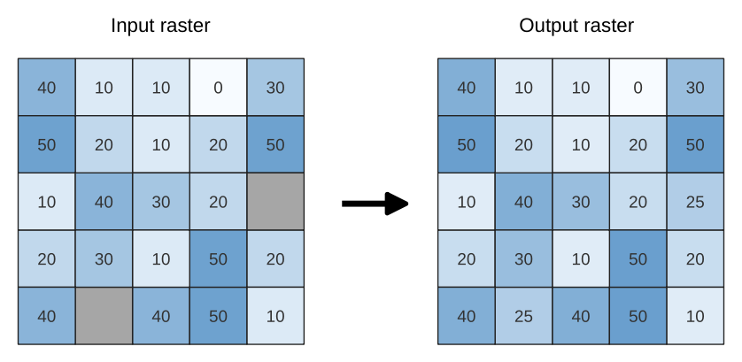
24.80. ábra Filling NoData values (in grey) of a raster
Paraméterek
Alapvető paraméterek
Címke |
Név |
Típus |
Leírás |
|---|---|---|---|
Input raster |
|
[raster] |
The raster to process. |
Band number |
|
[raster band] Default: 1 |
The band of the raster |
Fill value |
|
[numerikus: double] Default: 1.0 |
Set the value to use for the NoData pixels |
Output raster |
|
[raster] Alapértelmezett: |
Specification of the output raster. One of:
|
Speciális paraméterek
Címke |
Név |
Típus |
Leírás |
|---|---|---|---|
Creation options Optional
|
|
[karakterlánc] Default: «» |
For adding one or more creation options that control the raster to be created (colors, block size, file compression…). For convenience, you can rely on predefined profiles (see GDAL driver options section). Batch Process and Model Designer: separate multiple options with a pipe
character ( |
Kimenetek
Címke |
Név |
Típus |
Leírás |
|---|---|---|---|
Output raster |
|
[raster] |
The output raster layer with filled data cells. |
Python kód
Algorithm ID: native:fillnodata
import processing
processing.run("algorithm_id", {parameter_dictionary})
Az algoritmus azonosító akkor jelenik meg, ha az egérmutatót az algoritmus fölé viszi a Feldolgozás eszköztáron. A paraméterszótár tartalmazza a paraméter NAME-eket és érékeket. A feldolgozási algoritmusok Python konzolról történő futtatásával kapcsolatos részletekért lásd a Using processing algorithms from the console fejezetet.
24.1.21.5. Generate XYZ tiles (Directory)
Generates raster “XYZ” tiles using the current QGIS project as individual images to a directory structure.
Optionally, a Leaflet HTML output file using the generated tiles as a map layer could be created.
Paraméterek
Alapvető paraméterek
Címke |
Név |
Típus |
Leírás |
|---|---|---|---|
Extent (xmin, xmax, ymin, ymax) |
|
[terjedelem] |
Specify the extent of the tiles. It will internally be extended to a multiple of the tile size. A rendelkezésre álló módszerek a következők:
|
Minimum zoom |
|
[numerikus: egész szám] Default: 12 |
Minimum 0, maximum 25. |
Maximum zoom |
|
[numerikus: egész szám] Default: 12 |
Minimum 0, maximum 25. |
DPI |
|
[numerikus: egész szám] Default: 96 |
Minimum 48, maximum 600. |
Background color Optional |
|
[color] Default: QColor(0, 0, 0, 0) |
Choose the background color for the tiles |
Enable antialiasing |
|
[logikai] Alapértelmezett: Igaz |
Determines if antialiasing should be enabled |
Tile format |
|
[felsorolás] Alapértelmezett: 0 |
One of:
|
Quality (JPG only) Optional |
|
[numerikus: egész szám] Default: 75 |
Minimum 1, maximum 100. |
Metatile size Optional |
|
[numerikus: egész szám] Default: 4 |
Specify a custom metatile size when generating XYZ tiles. Larger values may speed up the rendering of tiles and provide better labelling (fewer gaps without labels) at the expense of using more memory. Minimum 1, maximum 20. |
Tile width Optional |
|
[numerikus: egész szám] Default: 256 |
Minimum 1, maximum 4096. |
Tile height Optional |
|
[numerikus: egész szám] Default: 256 |
Minimum 1, maximum 4096. |
Use inverted tile Y axis (TMS conventions) |
|
[logikai] Alapértelmezett: Hamis |
|
Kimeneti könyvtár |
|
[mappa] Default: |
Specification of the output directory (for the tiles). One of:
|
Output html (Leaflet) Optional |
|
[html] Alapértelmezett: |
Specification of the output HTML file. One of:
|
Speciális paraméterek
Címke |
Név |
Típus |
Leírás |
|---|---|---|---|
Leaflet HTML output title Optional
|
|
[karakterlánc] Alapértelmezett: nincs beállítva |
HTML <title>-tag used for the Leaflet HTML output file. |
Leaflet HTML output attribution Optional
|
|
[karakterlánc] Alapértelmezett: nincs beállítva |
Custom map attribution used for the Leaflet HTML output file. HTML links are possible. |
Include OpenStreetMap basemap in Leaflet HTML output
|
|
[logikai] Alapértelmezett: Hamis |
An OpenStreetMap basemap layer (source: https://tile.openstreetmap.org) is included in the Leaflet HTML output file. Proper map attribution is added automatically. |
Kimenetek
Címke |
Név |
Típus |
Leírás |
|---|---|---|---|
Kimeneti könyvtár |
|
[mappa] |
Output directory (for the tiles) |
Output html (Leaflet) |
|
[html] |
The output HTML (Leaflet) file |
Python kód
Algorithm ID: native:tilesxyzdirectory
import processing
processing.run("algorithm_id", {parameter_dictionary})
Az algoritmus azonosító akkor jelenik meg, ha az egérmutatót az algoritmus fölé viszi a Feldolgozás eszköztáron. A paraméterszótár tartalmazza a paraméter NAME-eket és érékeket. A feldolgozási algoritmusok Python konzolról történő futtatásával kapcsolatos részletekért lásd a Using processing algorithms from the console fejezetet.
24.1.21.6. Generate XYZ tiles (MBTiles)
Generates raster “XYZ” tiles using the current QGIS project as a single file in the “MBTiles” format.
Paraméterek
Címke |
Név |
Típus |
Leírás |
|---|---|---|---|
Extent (xmin, xmax, ymin, ymax) |
|
[terjedelem] |
Specify the extent of the tiles. It will internally be extended to a multiple of the tile size. A rendelkezésre álló módszerek a következők:
|
Minimum zoom |
|
[numerikus: egész szám] Default: 12 |
Minimum 0, maximum 25. |
Maximum zoom |
|
[numerikus: egész szám] Default: 12 |
Minimum 0, maximum 25. |
DPI |
|
[numerikus: egész szám] Default: 96 |
Minimum 48, maximum 600. |
Background color Optional |
|
[color] Default: QColor(0, 0, 0, 0) |
Choose the background color for the tiles |
Enable antialiasing |
|
[logikai] Alapértelmezett: Igaz |
Determines if antialiasing should be enabled |
Tile format |
|
[felsorolás] Alapértelmezett: 0 |
One of:
|
Quality (JPG only) Optional |
|
[numerikus: egész szám] Default: 75 |
Minimum 1, maximum 100. |
Metatile size Optional |
|
[numerikus: egész szám] Default: 4 |
Specify a custom metatile size when generating XYZ tiles. Larger values may speed up the rendering of tiles and provide better labelling (fewer gaps without labels) at the expense of using more memory. Minimum 1, maximum 20. |
Output file (for MBTiles) |
|
[fájl] Alapértelmezett: |
Specification of the output file. One of:
|
Kimenetek
Címke |
Név |
Típus |
Leírás |
|---|---|---|---|
Output file (for MBTiles) |
|
[fájl] |
The output file. |
Python kód
Algorithm ID: native:tilesxyzmbtiles
import processing
processing.run("algorithm_id", {parameter_dictionary})
Az algoritmus azonosító akkor jelenik meg, ha az egérmutatót az algoritmus fölé viszi a Feldolgozás eszköztáron. A paraméterszótár tartalmazza a paraméter NAME-eket és érékeket. A feldolgozási algoritmusok Python konzolról történő futtatásával kapcsolatos részletekért lásd a Using processing algorithms from the console fejezetet.