重要
翻訳は あなたが参加できる コミュニティの取り組みです。このページは現在 100.00% 翻訳されています。
20.1. GNSS/GPSデータの導入
20.1.1. GPSとは?
GPS、全地球測位システム、は、衛星型のシステムであり、GPS受信機さえあれば、世界中どこでも自分の正確な位置を知ることができます。GPSは航法の補助として、例えば飛行機やボート、ハイカーなどに利用されています。GPS受信機は、衛星からの信号を使って緯度、経度、(場合によっては)標高を算出します。ほとんどの受信機は次を保存する機能も持っています:
場所(ウェイポイント として知られています)
計画した 経路 を構成する場所の順序
そして受信機の異動の経時的な トラック ログ。
ウェイポイント、経路及びトラックは、GPSデータにおける三つの基本的な地物型です。QGISはウェイポイントをポイントレイヤに表示し、経路とトラックはラインストリングレイヤに表示されます。
注釈
QGISはGNSS受信機もサポートしています。しかし、この文書の作成ではGPSという用語を使っています。
20.1.2. GPSデータを転送又は読み込む
20.1.2.1. GPXファイルを読み込む
GPSデータを格納するためのファイル形式はいくつもあります。QGISが使用する形式はGPX(GPS交換フォーマット)と呼ばれ、同じファイルに任意の数のウェイポイント、ルート、トラックを含むことができる、標準の交換フォーマットです。
GPX ファイルを読み込むには:
データソースマネージャ ダイアログの GPS タブを開きます、つまり:
ツールバーの
 データソースマネージャを開く ボタンをクリックし(または Ctrl+L を押し)、目標のタブを有効にします
又は、
 を選択します
GPXデータセット オプションの隣にある ... ブラウズ ボタンを使ってGPXファイルを選びます
ファイルから読み込む 地物の型 を選ぶにはチェックボックスを使います。それぞれの地物の型(ウェイポイント、トラック 又は ルート)は別々のレイヤに読み込まれます。
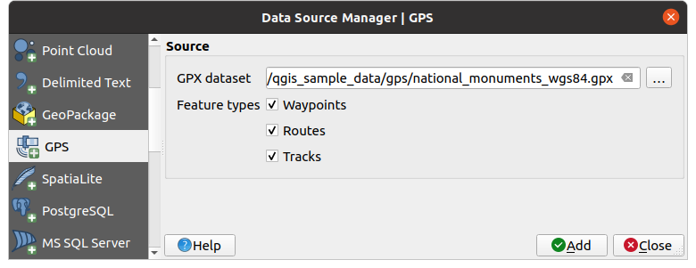
図 20.1 GPSデータの読み込みダイアログ
20.1.2.2. デバイスへ、またはデバイスから読み込む
GPSデバイスや形式には多くの種類があります。QGISはGPXファイルを使うので、他のGPSファイル形式をGPXに変換する方法が必要です。QGISはそれをフリーのプログラム GPSBabel を使ってすることができます。GPSBabelは、GarminやMagellanのような一般的なGPS受信機、Google EarthやBasecampのようなマッピングプログラムの間で、ウェイポイント、トラック、ルートを変換するのを助けてくれます。文字通り何百ものGPSレシーバーとプログラムがサポートされています。また、コンピュータとGPSデバイス間でGPSデータを転送することもできます。

 の下でQGISは独自のデバイスタイプを定義し、後で Processing GPS algorithms から使用できる変換パラメータを設定することができます。
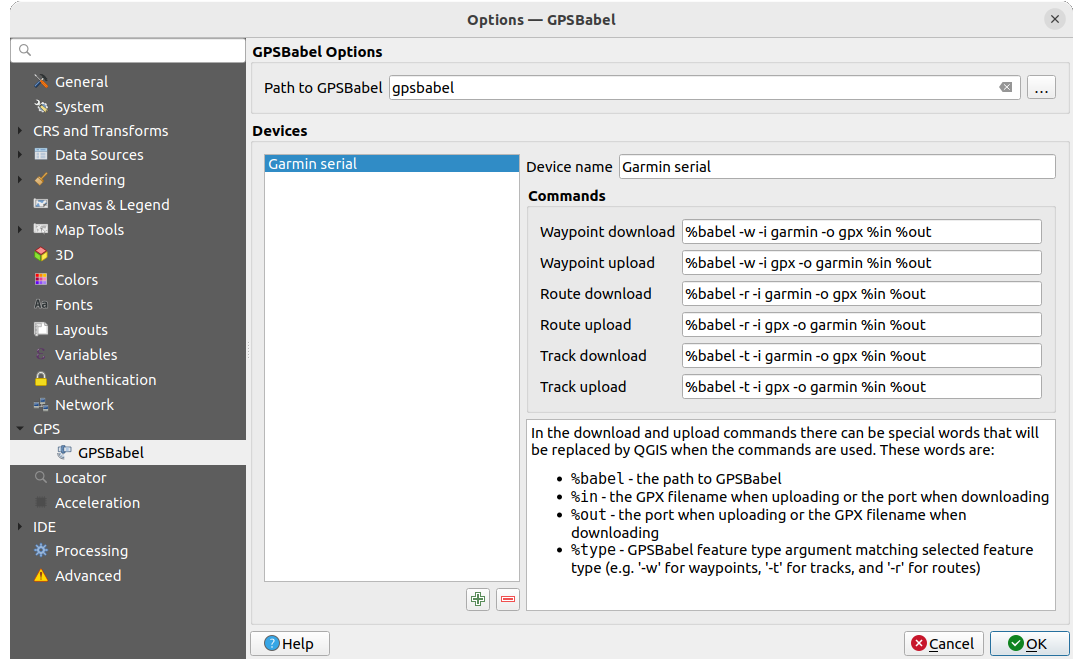
図 20.2 GPS Babelの設定
最初に、 GPSBabel のパス で、GPSBabelのバイナリへのパスを定義する必要があります。
次に、デバイスを追加します。デバイスのリストは
 新規デバイスを追加 ボタンや
  デバイスを削除 ボタンを使用して更新できます。
各デバイスについて、以下の設定ができます:
デバイス名 の設定
QGISがデバイスとのやり取りに使用するさまざまな コマンド の設定。例えば:
デバイスから ウェイポイントをダウンロード
デバイスへ ウェイポイントをアップロード
デバイスから ルートをダウンロード
デバイスへ ルートをアップロード
デバイスから トラックをダウンロード
デバイスへ トラックをアップロード
コマンドは通常、GPSBabelのコマンドですが、GPXファイルを作成することのできるその他のコマンドラインプログラムを使用することもできます。QGISはコマンドを実行する際に
%type、%in、%outのキーワードを置き換えます。例えば、ダウンロードコマンド
gpsbabel %type -i garmin -o gpx %in %outでデバイスタイプを作成し、それを使用してポート/dev/ttyS0からファイルoutput.gpxにウェイポイントをダウンロードすると、QGISはキーワードを置き換えて、コマンドgpsbabel -w -i garmin -o gpx /dev/ttyS0 output.gpxを実行します。自身のユースケースに特有のコマンドラインオプションについては、GPSBabel のマニュアルを確認してください。
新しいデバイスタイプを作成することができたら、GPSのダウンロード・アップロードアルゴリズムのデバイスリストに表示されます。
注釈
GPSユニットでは、異なる座標系でデータを保存できます。GPXファイルを(GPSユニットまたはウェブサイトから)ダウンロードし、QGISで読み込む場合は、GPXファイルに保存されているデータがWGS 84(緯度経度)を使用していることを確認してください。QGISはこれを期待しており、公式なGPX仕様です。GPX 1.1 Schema Documentation <https://www.topografix.com/GPX/1/1/>`_ を参照してください。