Ważne
Tłumaczenie jest wysiłkiem społeczności QGISa przyłącz się. Ta strona jest obecnie przetłumaczona w 62.55%.
24.1.15. Point Cloud Conversion
Uwaga
Running these algorithms requires QGIS installed with PDAL >= 2.5.0 (see menu).
24.1.15.1. Konwertuj format
Added in 3.32
Converts a point cloud to a different file format, e.g. creates a compressed .LAZ.
Parametry
Etykieta |
Nazwa |
Typ |
Opis |
|---|---|---|---|
Warstwa wejściowa |
|
[point cloud] |
Input point cloud layer to convert |
Przekonwertowany |
|
[point cloud] Domyślnie: |
Specify the point cloud file to use as output. One of:
|
Wyniki
Etykieta |
Nazwa |
Typ |
Opis |
|---|---|---|---|
Przekonwertowany |
|
[point cloud] |
Output point cloud layer in a modified file format.
Currently supported formats are |
Kod pythona
ID algorytmu: pdal:convertformat
import processing
processing.run("algorithm_id", {parameter_dictionary})
The algorithm id is displayed when you hover over the algorithm in the Processing Toolbox. The parameter dictionary provides the parameter NAMEs and values. See Using processing algorithms from the console for details on how to run processing algorithms from the Python console.
24.1.15.2. Export to raster
Added in 3.32
Exports point cloud data to a 2D raster grid having cell size of given resolution, writing values from the specified attribute.
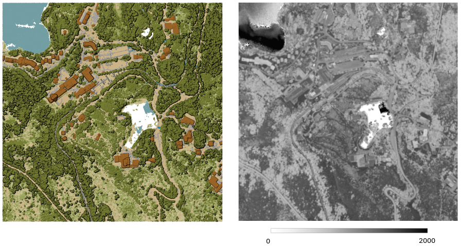
Rys. 24.41 Raster output using Intensity attribute of points
Parametry
Parametry podstawowe
Etykieta |
Nazwa |
Typ |
Opis |
|---|---|---|---|
Warstwa wejściowa |
|
[point cloud] |
Input point cloud layer to export |
Atrybut |
|
[field] [enumeration] |
A Field of the point cloud layer to extract the values from |
Resolution of the density raster |
|
[numeric: double] Domyślnie: 1.0 |
Cell size of the output raster |
Tile size for parallel runs |
|
[numeric: integer] Domyślnie: 1000 |
|
Wyeksportowane |
|
[raster] Domyślnie: |
Specify the raster file to export the data to. One of:
|
Parametry zaawansowane
Etykieta |
Nazwa |
Typ |
Opis |
|---|---|---|---|
Filter expression Opcjonalne |
|
[wyrażenie] |
A PDAL expression for selecting a subset of features in the point cloud data |
Cropping extent Opcjonalne |
|
[zasięg] |
A map extent for selecting a subset of features in the point cloud data Available methods are:
|
X origin of a tile for parallel runs Opcjonalne |
|
[numeric: double] |
|
Y origin of a tile for parallel runs Opcjonalne |
|
[numeric: double] |
Wyniki
Etykieta |
Nazwa |
Typ |
Opis |
|---|---|---|---|
Wyeksportowane |
|
[raster] |
Output raster layer features of the point cloud layer are exported to.
Currently supported format is |
Kod pythona
ID algorytmu: pdal:exportraster
import processing
processing.run("algorithm_id", {parameter_dictionary})
The algorithm id is displayed when you hover over the algorithm in the Processing Toolbox. The parameter dictionary provides the parameter NAMEs and values. See Using processing algorithms from the console for details on how to run processing algorithms from the Python console.
24.1.15.3. Export to raster (using triangulation)
Added in 3.32
Exports point cloud data to a 2D raster grid using a triangulation of points and then interpolating cell values from triangles.
Informacja
Using this algorithm can be slower if you are dealing with a large dataset. If your point cloud is dense, you can export your ground points as a raster using the Export to raster algorithm.

Rys. 24.42 Terrain raster output generated by point cloud triangulation
Parametry
Parametry podstawowe
Etykieta |
Nazwa |
Typ |
Opis |
|---|---|---|---|
Warstwa wejściowa |
|
[point cloud] |
Input point cloud layer to export |
Resolution of the density raster |
|
[numeric: double] Domyślnie: 1.0 |
Cell size of the output raster |
Tile size for parallel runs |
|
[numeric: integer] Domyślnie: 1000 |
|
Wyeksportowane |
|
[raster] Domyślnie: |
Specify the raster file to export the data to. One of:
|
Parametry zaawansowane
Etykieta |
Nazwa |
Typ |
Opis |
|---|---|---|---|
Filter expression Opcjonalne |
|
[wyrażenie] |
A PDAL expression for selecting a subset of features in the point cloud data |
Cropping extent Opcjonalne |
|
[zasięg] |
A map extent for selecting a subset of features in the point cloud data Available methods are:
|
X origin of a tile for parallel runs Opcjonalne |
|
[numeric: double] |
|
Y origin of a tile for parallel runs Opcjonalne |
|
[numeric: double] |
Wyniki
Etykieta |
Nazwa |
Typ |
Opis |
|---|---|---|---|
Exported (using triangulation) |
|
[raster] |
Output raster layer features of the point cloud layer are exported to.
Currently supported format is |
Kod pythona
ID algorytmu: pdal:exportrastertin
import processing
processing.run("algorithm_id", {parameter_dictionary})
The algorithm id is displayed when you hover over the algorithm in the Processing Toolbox. The parameter dictionary provides the parameter NAMEs and values. See Using processing algorithms from the console for details on how to run processing algorithms from the Python console.
24.1.15.4. Export to vector
Added in 3.32
Exports point cloud data to a vector layer with 3D points (a GeoPackage), optionally with extra attributes.
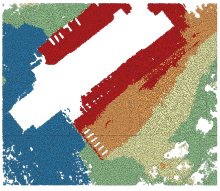
Rys. 24.43 Exporting point cloud (ground points) to a vector layer styled based on the elevation
Parametry
Parametry podstawowe
Etykieta |
Nazwa |
Typ |
Opis |
|---|---|---|---|
Warstwa wejściowa |
|
[point cloud] |
Input point cloud layer to export |
Atrybut Opcjonalne |
|
[field] [list] |
One or more fields of the point cloud layer to export with the points. |
Wyeksportowane |
|
[wektor] Domyślnie: |
Specify the vector file to export the data to. One of:
|
Parametry zaawansowane
Etykieta |
Nazwa |
Typ |
Opis |
|---|---|---|---|
Filter expression Opcjonalne |
|
[wyrażenie] |
A PDAL expression for selecting a subset of features in the point cloud data |
Cropping extent Opcjonalne |
|
[zasięg] |
A map extent for selecting a subset of features in the point cloud data Available methods are:
|
Wyniki
Etykieta |
Nazwa |
Typ |
Opis |
|---|---|---|---|
Wyeksportowane |
|
[wektor] |
Output vector layer features of the point cloud layer are exported to.
Currently supported format is |
Kod pythona
ID algorytmu: pdal:exportvector
import processing
processing.run("algorithm_id", {parameter_dictionary})
The algorithm id is displayed when you hover over the algorithm in the Processing Toolbox. The parameter dictionary provides the parameter NAMEs and values. See Using processing algorithms from the console for details on how to run processing algorithms from the Python console.