Svarbu
Vertimas yra bendruomenės pastangos, prie kurių jūs galite prisijungti. Šis puslapis šiuo metu išverstas 36.54%.
23.2. Apdorojimo karkaso konfigūravimas
Apdorojimo parinkčių meniu (  Apdorojimas kortelė) leidžia jums konfigūruoti, kaip veikia algoritmai. Konfigūracijos parametrų struktūroje yra atskiri blokai, kuriuos jūs galite parinkti kairėje dialogo pusėje.
23.2.1. Bendra
Skiltyje Bendra yra numatytieji nustatymai, valdantys algoritmų dialogų bei įvesties ar išvesties parametrų elgseną. Kai kuriuos nustatymus visgi galima permušti algoritmų lygyje konkrečiam algoritmo paleidimui ar individualiems parametrams.
Numatytas išvesties rastro sluoksnio išplėtimas pagal nutylėjimą yra
tifNumatytasis išvesties vektoriaus sluoksnio išplėtimas pagal nutylėjimą yra
gpkgNeteisingų geoobjektų filtravimas vykdant algoritmą:
Nefiltruoti (geresnė greitaveika): apdorojami visi geoobjektai (su tinkamomis ir netinkamomis geometrijomis), bet rezultatas gali būti klaidingas priklausomai nuo to, kaip geometrijos netinkamumas įtakoja veiksmus
Praleisti (ignoruoti) geoobjektus su netinkamomis geometrijomis, tai reiškia, kad bus apdorotas tik jūsų duomenų aibės poaibis (geoobjektai su tinkama geometrija)
Stabdyti algoritmo vykdymą, kai geometrija yra netinkama: jums reikės sekti ir taisyti netinkamas geometrijas, jei norėsite, kad algoritmas apdorotų visą sluoksnį. Algoritmai, tokie kaip Tikrinti tvarkingumą ar Fix geometries jums gali padėti tai padaryti.
Netinkamų geoobjektų filtravimo nustatymą galima permušti algoritmo vykdymo metu kiekvienam įvesties rinkiniui.
Palikti dialogą atvertą po algoritmo įvykdymo. Kai algoritmo vykdymas baigiamas ir jo išvesties sluoksniai įkeliami į QGIS projektą, algoritmo dialogas uždaromas. Įjunkite šią parinktį, jei norite, kad jis liktų atvertas (kad dar kartą paleistumėte algoritmą su kitokiais parametrais ar įdėmiau peržvelgtumėte išvestį žurnalo kortelėje).
Maksimalus gijų skaičius
Output folder for non temporary outputs: If no folder path is provided for the Processing execution outputs, this is the folder in which they will be saved. Default is
processingunder the user home directory (e.g.,C:\Users\<YOURUSERNAME>\processing\on Windows).
Override temporary output folder path: Temporary outputs are saved by default in the
tmpfolder on the machine. This option helps you set a different place for storage.Pre-execution script and Post-execution script. These parameters point to files that contain scripts written using the processing scripting functionality, explained in the section covering scripting and the console.
Prefer output filename for layer names. The name of each resulting layer created by an algorithm is defined by the algorithm itself. In some cases, a fixed name might be used, meaning that the same output name will be used, no matter which input layer is used. In other cases, the name might depend on the name of the input layer or some of the parameters used to run the algorithm. If this checkbox is checked, the name will be taken from the output filename instead. Notice that, if the output is saved to a temporary file, the filename of this temporary file is usually a long and meaningless one intended to avoid collision with other already existing filenames.
Results group name. If you want to obtain all processing result layers in a group in the Layers panel, set a group name for this parameter. The group may exist already or not. QGIS will add all output layers to such a group. By default, this parameter is empty, so all output layers are added to different places in the Layers panel, depending on the item that is active when running an algorithm. Note that output layers will be loaded to the Layers panel only if Open output file after running algorithm is checked in the algorithm dialog.
Show algorithms with known issues: By default, QGIS avoids display of broken algorithms (generally from third-party providers). If checked, they will be available in the Processing toolbox, with a warning icon and a tooltip explaining they have issues. Use at your own risks.
Show feature count for output vector layers. Since calculating the feature count might take some time in certain data formats, this option is off by default.
Show layer CRS definition in selection boxes
Show tooltip when there are disabled providers
Style for line layers, Style for point layers, Style for polygons layers and Style for raster layers are used for setting the default rendering style for output layers (that is, layers generated by processing algorithms). Just create the style you want using QGIS, save it to a file, and then enter the path to that file in the settings so the algorithms can use it. Whenever a layer is loaded by Processing and added to the QGIS canvas, it will be rendered with that style.
Rendering styles can be configured individually for each algorithm and each one of its outputs. Just right-click on the name of the algorithm in the toolbox and select Edit rendering styles for outputs. You will see a dialog like the one shown next.
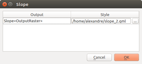
Fig. 23.5 Rendering Styles
Select the style file (
.qml) that you want for each output and press OK.Warn before executing if parameter CRS’s do not match: By default, QGIS native algorithms (i.e. the ones listed under the
 group)
transparently reproject the input layers to the first one’s CRS before execution.
Check this option to get a notification from the other tools that do not suppport reprojection,
when the inputs CRS are not identical.
Third-party providers are not concerned.
group)
transparently reproject the input layers to the first one’s CRS before execution.
Check this option to get a notification from the other tools that do not suppport reprojection,
when the inputs CRS are not identical.
Third-party providers are not concerned.
23.2.2. Menus
The Menus block controls whether an algorithm, script or
model (built-in or provided by plugins) should be made available
through a dedicated menu or toolbar (along with the Processing Toolbox).
For each item of each provider, you can:
Add button in toolbar, making it available in the Processing Algorithms toolbar
assign an Icon to the algorithm
set a Menu path: the algorithm will then be available through an existing or a custom menu, e.g.
Vect&or/MyTopAlgorithmswill add a shortcut in a sub-menu of the default menu.
Restart QGIS to apply the settings. At any time, your changes can be Reset to defaults.
23.2.3. Models and Scripts
In the  Models and
  Scripts blocks,
a default path, set under the active User profile folder,
is provided for storing models and scripts respectively.
As for the other options, you can modify the path, e.g., to lead to a remote or shared folder
for all your users.
Scripts blocks,
a default path, set under the active User profile folder,
is provided for storing models and scripts respectively.
As for the other options, you can modify the path, e.g., to lead to a remote or shared folder
for all your users.
23.2.4. Providers
You will also find a block for algorithm Providers.
This is the place where installed providers expose their settings.
By default, QGIS is installed with two algorithm providers:
GDAL whose algorithms you may Activate (or not) in this dialog. Read more about the GDAL algorithms.
GRASS whose algorithms require the installation of the GRASS GIS Processing Provider from the Plugins Manager. You could then set some dedicated settings such as:
 For raster layers, use r.external (faster) instead of r.in.gdal
- For vector layers, use v.external (faster) instead of v.in.ogr
Location of GRASS docs: by default, and depending on your OS, QGIS utilizes a hardcoded list of paths for finding the local GRASS documentation and opening it whenever you hit the Help button of a GRASS algorithm dialog. Filling this option will override the default path, allowing you to use a custom location, or remote documentation.
- Log console output
- Log execution commands
Installed plugins that provide Processing algorithms may also have their provider listed in this group, with custom settings.