23.1.14. Vector general
23.1.14.1. Assign projection
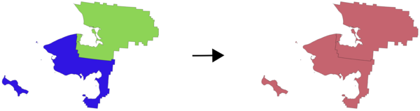
Assigns a new projection to a vector layer.
It creates a new layer with the exact same features and geometries as the input one, but assigned to a new CRS. The geometries are not reprojected, they are just assigned to a different CRS.
This algorithm can be used to repair layers which have been assigned an incorrect projection.
Attributes are not modified by this algorithm.
23.1.14.1.1. Parameters
Label |
Name |
Type |
Description |
|---|---|---|---|
Input layer |
|
[vector: any] |
Vector layer with wrong or missing CRS |
Assigned CRS |
|
[crs] Default: |
Select the new CRS to assign to the vector layer |
Assigned CRS (Optional) |
|
[same as input] Default: |
Specify the output layer containing only the duplicates. One of:
The file encoding can also be changed here. |
23.1.14.1.2. Outputs
Label |
Name |
Type |
Description |
|---|---|---|---|
Assigned CRS |
|
[same as input] |
Vector layer with assigned projection |
23.1.14.1.3. Python code
Algorithm ID: qgis:assignprojection
import processing
processing.run("algorithm_id", {parameter_dictionary})
The algorithm id is displayed when you hover over the algorithm in the Processing Toolbox. The parameter dictionary provides the parameter NAMEs and values. See Using processing algorithms from the console for details on how to run processing algorithms from the Python console.
23.1.14.2. Build virtual vector
Creates a virtual vector layer that contains a set of vector layer. The output virtual vector layer will not be open in the current project.
This algorithm is especially useful in case another algorithm needs multiple
layers but accept only one vrt in which the layers are specified.
23.1.14.2.1. Parameters
Label |
Name |
Type |
Description |
|---|---|---|---|
Input datasources |
|
[vector: any] [list] |
Select the vector layers you want to use to build the virtual vector |
Create “unioned” VRT |
|
[boolean] Default: False |
Check if you want to unite all the vectors in a
single |
Virtual vector |
|
[same as input] Default: |
Specify the output layer containing only the duplicates. One of:
The file encoding can also be changed here. |
23.1.14.2.2. Outputs
Label |
Name |
Type |
Description |
|---|---|---|---|
Virtual vector |
|
[vector: any] |
The output virtual vector made from the chosen sources |
23.1.14.3. Convert layer to spatial bookmarks
Creates spatial bookmarks corresponding to the extent of features contained in a layer.
23.1.14.3.1. Parameters
Label |
Name |
Type |
Description |
|---|---|---|---|
Input Layer |
|
[vector: line, polygon] |
The input vector layer |
Bookmark destination |
|
[enumeration] Default: 0 |
Select the destination for the bookmarks. One of:
|
Name field |
|
[expression] |
Field or expression that will give names to the generated bookmarks |
Group field |
|
[expression] |
Field or expression that will provide groups for the generated bookmarks |
23.1.14.3.2. Outputs
Label |
Name |
Type |
Description |
|---|---|---|---|
Count of bookmarks added |
|
[number] |
23.1.14.3.3. Python code
Algorithm ID: qgis:layertobookmarks
import processing
processing.run("algorithm_id", {parameter_dictionary})
The algorithm id is displayed when you hover over the algorithm in the Processing Toolbox. The parameter dictionary provides the parameter NAMEs and values. See Using processing algorithms from the console for details on how to run processing algorithms from the Python console.
23.1.14.4. Convert spatial bookmarks to layer
Creates a new layer containing polygon features for stored spatial bookmarks. The export can be filtered to only bookmarks belonging to the current project, to all user bookmarks, or a combination of both.
23.1.14.4.1. Parameters
Label |
Name |
Type |
Description |
|---|---|---|---|
Bookmark source |
|
[enumeration] [list] Default: [0,1] |
Select the source(s) of the bookmarks. One or more of:
|
Output CRS |
|
[crs] Default: |
The CRS of the output layer |
Output |
|
[vector: polygon] Default: |
Specify the output layer. One of:
The file encoding can also be changed here. |
23.1.14.4.2. Outputs
Label |
Name |
Type |
Description |
|---|---|---|---|
Output |
|
[vector: polygon] |
The output (bookmarks) vector layer |
23.1.14.4.3. Python code
Algorithm ID: qgis:bookmarkstolayer
import processing
processing.run("algorithm_id", {parameter_dictionary})
The algorithm id is displayed when you hover over the algorithm in the Processing Toolbox. The parameter dictionary provides the parameter NAMEs and values. See Using processing algorithms from the console for details on how to run processing algorithms from the Python console.
23.1.14.5. Create attribute index
Creates an index against a field of the attribute table to speed up queries. The support for index creation depends on both the layer’s data provider and the field type.
No outputs are created: the index is stored on the layer itself.
23.1.14.5.1. Parameters
Label |
Name |
Type |
Description |
|---|---|---|---|
Input Layer |
|
[vector: any] |
Select the vector layer you want to create an attribute index for |
Attribute to index |
|
[tablefield: any] |
Field of the vector layer |
23.1.14.5.2. Outputs
Label |
Name |
Type |
Description |
|---|---|---|---|
Indexed layer |
|
[same as input] |
A copy of the input vector layer with an index for the specified field |
23.1.14.5.3. Python code
Algorithm ID: qgis:createattributeindex
import processing
processing.run("algorithm_id", {parameter_dictionary})
The algorithm id is displayed when you hover over the algorithm in the Processing Toolbox. The parameter dictionary provides the parameter NAMEs and values. See Using processing algorithms from the console for details on how to run processing algorithms from the Python console.
23.1.14.6. Create spatial index
Creates an index to speed up access to the features in a layer based on their spatial location. Support for spatial index creation is dependent on the layer’s data provider.
No new output layers are created.
Default menu:
23.1.14.6.1. Parameters
Label |
Name |
Type |
Description |
|---|---|---|---|
Input Layer |
|
[vector: any] |
Input vector layer |
23.1.14.6.2. Outputs
Label |
Name |
Type |
Description |
|---|---|---|---|
Indexed layer |
|
[same as input] |
A copy of the input vector layer with a spatial index |
23.1.14.6.3. Python code
Algorithm ID: qgis:createspatialindex
import processing
processing.run("algorithm_id", {parameter_dictionary})
The algorithm id is displayed when you hover over the algorithm in the Processing Toolbox. The parameter dictionary provides the parameter NAMEs and values. See Using processing algorithms from the console for details on how to run processing algorithms from the Python console.
23.1.14.7. Define Shapefile projection
Sets the CRS (projection) of an existing Shapefile format dataset to
the provided CRS.
It is very useful when a Shapefile format dataset is missing the
prj file and you know the correct projection.
Contrary to the Assign projection algorithm, it modifies the current layer and will not output a new layer.
Note
For Shapefile datasets, the .prj and .qpj files will
be overwritten - or created if missing - to match the provided CRS.
Default menu:
See also
23.1.14.7.1. Parameters
Label |
Name |
Type |
Description |
|---|---|---|---|
Input layer |
|
[vector: any] |
Vector layer with missing projection information |
CRS |
|
[crs] |
Select the CRS to assign to the vector layer |
23.1.14.7.2. Outputs
Label |
Name |
Type |
Description |
|---|---|---|---|
|
[same as input] |
The input vector layer with the defined projection |
23.1.14.7.3. Python code
Algorithm ID: qgis:definecurrentprojection
import processing
processing.run("algorithm_id", {parameter_dictionary})
The algorithm id is displayed when you hover over the algorithm in the Processing Toolbox. The parameter dictionary provides the parameter NAMEs and values. See Using processing algorithms from the console for details on how to run processing algorithms from the Python console.
23.1.14.8. Delete duplicate geometries
Finds and removes duplicated geometries.
Attributes are not checked, so in case two features have identical geometries but different attributes, only one of them will be added to the result layer.
23.1.14.8.1. Parameters
Label |
Name |
Type |
Description |
|---|---|---|---|
Input layer |
|
[vector: any] |
The layer with duplicate geometries you want to clean |
Cleaned |
|
[same as input] Default: |
Specify the output layer. One of:
The file encoding can also be changed here. |
23.1.14.8.2. Outputs
Label |
Name |
Type |
Description |
|---|---|---|---|
Count of discarded duplicate records |
|
[number] |
Count of discarded duplicate records |
Cleaned |
|
[same as input] |
The output layer without any duplicated geometries |
Count of retained records |
|
[number] |
Count of unique records |
23.1.14.8.3. Python code
Algorithm ID: qgis:deleteduplicategeometries
import processing
processing.run("algorithm_id", {parameter_dictionary})
The algorithm id is displayed when you hover over the algorithm in the Processing Toolbox. The parameter dictionary provides the parameter NAMEs and values. See Using processing algorithms from the console for details on how to run processing algorithms from the Python console.
23.1.14.9. Delete duplicates by attribute
Deletes duplicate rows by only considering the specified field / fields. The first matching row will be retained, and duplicates will be discarded.
Optionally, these duplicate records can be saved to a separate output for analysis.
See also
23.1.14.9.1. Parameters
Label |
Name |
Type |
Description |
|---|---|---|---|
Input layer |
|
[vector: any] |
The input layer |
Fields to match duplicates by |
|
[tablefield: any] [list] |
Fields defining duplicates. Features with identical values for all these fields are considered duplicates. |
Filtered (no duplicates) |
|
[same as input] Default: |
Specify the output layer containing the unique features. One of:
The file encoding can also be changed here. |
Filtered (duplicates) (Optional) |
|
[same as input] Default: |
Specify the output layer containing only the duplicates. One of:
The file encoding can also be changed here. |
23.1.14.9.2. Outputs
Label |
Name |
Type |
Description |
|---|---|---|---|
Filtered (duplicates) Optional |
|
[same as input] Default: |
Vector layer containing the removed features.
Will not be produced if not specified (left as
|
Count of discarded duplicate records |
|
[number] |
Count of discarded duplicate records |
Filtered (no duplicates) |
|
[same as input] |
Vector layer containing the unique features. |
Count of retained records |
|
[number] |
Count of unique records |
23.1.14.9.3. Python code
Algorithm ID: qgis:deleteduplicatesbyattribute
import processing
processing.run("algorithm_id", {parameter_dictionary})
The algorithm id is displayed when you hover over the algorithm in the Processing Toolbox. The parameter dictionary provides the parameter NAMEs and values. See Using processing algorithms from the console for details on how to run processing algorithms from the Python console.
23.1.14.10. Drop geometries
Creates a simple geometryless copy of the input layer attribute table. It keeps the attribute table of the source layer.
If the file is saved in a local folder, you can choose between many file formats.
 Allows features in-place modification
23.1.14.10.1. Parameters
Label |
Name |
Type |
Description |
|---|---|---|---|
Input layer |
|
[vector: any] |
The input vector layer |
Dropped geometries |
|
[table] |
Specify the output geometryless layer. One of:
The file encoding can also be changed here. |
23.1.14.10.2. Outputs
Label |
Name |
Type |
Description |
|---|---|---|---|
Dropped geometries |
|
[table] |
The output geometryless layer. A copy of the original attribute table. |
23.1.14.10.3. Python code
Algorithm ID: qgis:dropgeometries
import processing
processing.run("algorithm_id", {parameter_dictionary})
The algorithm id is displayed when you hover over the algorithm in the Processing Toolbox. The parameter dictionary provides the parameter NAMEs and values. See Using processing algorithms from the console for details on how to run processing algorithms from the Python console.
23.1.14.11. Execute SQL
Runs a simple or complex query with SQL syntax on the source
layer.
Input datasources are identified with input1, input2… inputN and
a simple query will look like SELECT * FROM input1.
Beside a simple query, you can add expressions or variables within the
SQL query parameter itself. This is particulary useful if this algorithm is
executed within a Processing model and you want to use a model input as a
parameter of the query. An example of a query will then be SELECT * FROM
[% @table %] where @table is the variable that identifies the model input.
The result of the query will be added as a new layer.
See also
23.1.14.11.1. Parameters
Label |
Name |
Type |
Description |
|---|---|---|---|
Additional input datasources (called input1, .., inputN in the query) |
|
[vector: any] [list] |
List of layers to query. In the SQL editor you can refer these layers with their real name or also with input1, input2, inputN depending on how many layers have been chosen. |
SQL query |
|
[string] |
Type the string of your SQL query, e.g.
|
Unique identifier field Optional |
|
[string] |
Specify the column with unique ID |
Geometry field Optional |
|
[string] |
Specify the geometry field |
Geometry type Optional |
|
[enumeration] Default: 0 |
Choose the geometry of the result. By default the algorithm will autodetect it. One of:
|
CRS Optional |
|
[crs] |
The CRS to assign to the output layer |
SQL Output |
|
[vector: any] Default: |
Specify the output layer created by the query. One of:
The file encoding can also be changed here. |
23.1.14.11.2. Outputs
Label |
Name |
Type |
Description |
|---|---|---|---|
SQL Output |
|
[vector: any] |
Vector layer created by the query |
23.1.14.11.3. Python code
Algorithm ID: qgis:executesql
import processing
processing.run("algorithm_id", {parameter_dictionary})
The algorithm id is displayed when you hover over the algorithm in the Processing Toolbox. The parameter dictionary provides the parameter NAMEs and values. See Using processing algorithms from the console for details on how to run processing algorithms from the Python console.
23.1.14.12. Extract selected features
Saves the selected features as a new layer.
Note
If the selected layer has no selected features, the newly created layer will be empty.
23.1.14.12.1. Parameters
Label |
Name |
Type |
Description |
|---|---|---|---|
Input Layer |
|
[vector: any] |
Layer to save the selection from |
Selected features |
|
[same as input] Default: |
Specify the vector layer for the selected features. One of:
The file encoding can also be changed here. |
23.1.14.12.2. Outputs
Label |
Name |
Type |
Description |
|---|---|---|---|
Selected features |
|
[same as input] |
Vector layer with only the selected features, or no feature if none was selected. |
23.1.14.12.3. Python code
Algorithm ID: qgis:saveselectedfeatures
import processing
processing.run("algorithm_id", {parameter_dictionary})
The algorithm id is displayed when you hover over the algorithm in the Processing Toolbox. The parameter dictionary provides the parameter NAMEs and values. See Using processing algorithms from the console for details on how to run processing algorithms from the Python console.
23.1.14.13. Find projection
Creates a shortlist of candidate coordinate reference systems, for instance for a layer with an unknown projection.
The area that the layer is expected to cover must be specified via the target area parameter. The coordinate reference system for this target area must be known to QGIS.
The algorithm operates by testing the layer’s extent in every known reference system and then listing any for which the bounds would be near the target area if the layer was in this projection.
23.1.14.13.1. Parameters
Label |
Name |
Type |
Description |
|---|---|---|---|
Input Layer |
|
[vector: any] |
Layer with unknown projection |
Target area for layer (xmin, xmax, ymin, ymax) |
|
[extent] |
The area that the layer covers. The options for specifying the extent are:
It is also possible to provide the extent coordinates directly (xmin, xmax, ymin, ymax). |
CRS candidates |
|
[table] Default: |
Specify the table (geometryless layer) for the CRS suggestions (EPSG codes). One of:
The file encoding can also be changed here. |
23.1.14.13.2. Outputs
Label |
Name |
Type |
Description |
|---|---|---|---|
CRS candidates |
|
[table] |
A table with all the CRS (EPSG codes) of the matching criteria. |
23.1.14.13.3. Python code
Algorithm ID: qgis:findprojection
import processing
processing.run("algorithm_id", {parameter_dictionary})
The algorithm id is displayed when you hover over the algorithm in the Processing Toolbox. The parameter dictionary provides the parameter NAMEs and values. See Using processing algorithms from the console for details on how to run processing algorithms from the Python console.
23.1.14.14. Join attributes by field value
Takes an input vector layer and creates a new vector layer that is an extended version of the input one, with additional attributes in its attribute table.
The additional attributes and their values are taken from a second vector layer. An attribute is selected in each of them to define the join criteria.
23.1.14.14.1. Parameters
Label |
Name |
Type |
Description |
|---|---|---|---|
Input Layer |
|
[vector: any] |
Input vector layer. The output layer will consist of the features of this layer with attributes from matching features in the second layer. |
Table field |
|
[tablefield: any] |
Field of the source layer to use for the join |
Input layer 2 |
|
[vector: any] |
Layer with the attribute table to join |
Table field 2 |
|
[tablefield: any] |
Field of the second (join) layer to use for the join The type of the field must be equal to (or compatible with) the input table field type. |
Layer 2 fields to copy Optional |
|
[tablefield: any] [list] |
Select the specific fields you want to add. By default all the fields are added. |
Join type |
|
[enumeration] Default: 1 |
The type of the final joined layer. One of:
|
Discard records which could not be joined |
|
[boolean] Default: True |
Check if you don’t want to keep the features that could not be joined |
Joined field prefix Optional |
|
[string] |
Add a prefix to joined fields in order to easily identify them and avoid field name collision |
Joined layer |
|
[same as input] Default: |
Specify the output vector layer for the join. One of:
The file encoding can also be changed here. |
Unjoinable features from first layer |
|
[same as input] Default: |
Specify the output vector layer for unjoinable features from first layer. One of:
The file encoding can also be changed here. |
23.1.14.14.2. Outputs
Label |
Name |
Type |
Description |
|---|---|---|---|
Number of joined features from input table |
|
[number] |
|
Unjoinable features from first layer Optional |
|
[same as input] |
Vector layer with the non-matched features |
Joined layer |
|
[same as input] |
Output vector layer with added attributes from the join |
Number of unjoinable features from input table Optional |
|
[number] |
23.1.14.14.3. Python code
Algorithm ID: qgis:joinattributestable
import processing
processing.run("algorithm_id", {parameter_dictionary})
The algorithm id is displayed when you hover over the algorithm in the Processing Toolbox. The parameter dictionary provides the parameter NAMEs and values. See Using processing algorithms from the console for details on how to run processing algorithms from the Python console.
23.1.14.15. Join attributes by location
Takes an input vector layer and creates a new vector layer that is an extended version of the input one, with additional attributes in its attribute table.
The additional attributes and their values are taken from a second vector layer. A spatial criteria is applied to select the values from the second layer that are added to each feature from the first layer.
Default menu:
See also
Join attributes by nearest, Join attributes by field value, Join attributes by location (summary)
23.1.14.15.1. Parameters
Label |
Name |
Type |
Description |
|---|---|---|---|
Input Layer |
|
[vector: any] |
Input vector layer. The output layer will consist of the features of this layer with attributes from matching features in the second layer. |
Join layer |
|
[vector: any] |
The attributes of this vector layer will be added to the source layer attribute table. |
Geometric predicate |
|
[enumeration] [list] Default: [0] |
Select the geometric criteria. One or more of:
|
Fields to add (leave empty to use all fields) Optional |
|
[tablefield: any] [list] |
Select the specific fields you want to add. By default all the fields are added. |
Join type |
|
[enumeration] |
The type of the final joined layer. One of:
|
Discard records which could not be joined |
|
[boolean] Default: False |
Remove from the output the input layer records which could not be joined |
Joined field prefix Optional |
|
[string] |
Add a prefix to joined fields in order to easily identify them and avoid field name collision |
Joined layer |
|
[same as input] Default: |
Specify the output vector layer for the join. One of:
The file encoding can also be changed here. |
Unjoinable features from first layer |
|
[same as input] Default: |
Specify the output vector layer for unjoinable features from first layer. One of:
The file encoding can also be changed here. |
23.1.14.15.2. Outputs
Label |
Name |
Type |
Description |
|---|---|---|---|
Number of joined features from input table |
|
[number] |
|
Unjoinable features from first layer Optional |
|
[same as input] |
Vector layer of the non-matched features |
Joined layer |
|
[same as input] |
Output vector layer with added attributes from the join |
23.1.14.15.3. Python code
Algorithm ID: qgis:joinattributesbylocation
import processing
processing.run("algorithm_id", {parameter_dictionary})
The algorithm id is displayed when you hover over the algorithm in the Processing Toolbox. The parameter dictionary provides the parameter NAMEs and values. See Using processing algorithms from the console for details on how to run processing algorithms from the Python console.
23.1.14.16. Join attributes by location (summary)
Takes an input vector layer and creates a new vector layer that is an extended version of the input one, with additional attributes in its attribute table.
The additional attributes and their values are taken from a second vector layer. A spatial criteria is applied to select the values from the second layer that are added to each feature from the first layer.
The algorithm calculates a statistical summary for the values from matching features in the second layer (e.g. maximum value, mean value, etc).
See also
23.1.14.16.1. Parameters
Label |
Name |
Type |
Description |
|---|---|---|---|
Input Layer |
|
[vector: any] |
Input vector layer. The output layer will consist of the features of this layer with attributes from matching features in the second layer. |
Join layer |
|
[vector: any] |
The attributes of this vector layer will be added to the source layer attribute table. |
Geometric predicate |
|
[enumeration] [list] Default: [0] |
Select the geometric criteria. One or more of:
|
Fields to summarize (leave empty to use all fields) Optional |
|
[tablefield: any] [list] |
Select the specific fields you want to add and summarize. By default all the fields are added. |
Summaries to calculate (leave empty to use all fields) Optional |
|
[enumeration] [list] Default: [] |
Choose which type of summary you want to add to each field and for each feature. One or more of:
|
Discard records which could not be joined |
|
[boolean] Default: False |
Remove from the output the input layer records which could not be joined |
Joined layer |
|
[same as input] Default: |
Specify the output vector layer for the join. One of:
The file encoding can also be changed here. |
23.1.14.16.2. Outputs
Label |
Name |
Type |
Description |
|---|---|---|---|
Joined layer |
|
[same as input] |
Output vector layer with summarized attributes from the join |
23.1.14.16.3. Python code
Algorithm ID: qgis:joinbylocationsummary
import processing
processing.run("algorithm_id", {parameter_dictionary})
The algorithm id is displayed when you hover over the algorithm in the Processing Toolbox. The parameter dictionary provides the parameter NAMEs and values. See Using processing algorithms from the console for details on how to run processing algorithms from the Python console.
23.1.14.17. Join attributes by nearest
Takes an input vector layer and creates a new vector layer with additional fields in its attribute table. The additional attributes and their values are taken from a second vector layer. Features are joined by finding the closest features from each layer.
By default only the nearest feature is joined, but the join can also join to the k-nearest neighboring features.
If a maximum distance is specified, only features which are closer than this distance will be matched.
See also
Nearest neighbour analysis, Join attributes by field value, Join attributes by location, Distance matrix
23.1.14.17.1. Parameters
Label |
Name |
Type |
Description |
|---|---|---|---|
Input layer |
|
[vector: any] |
The input layer. |
Input layer 2 |
|
[vector: any] |
The join layer. |
Layer 2 fields to copy (leave empty to copy all fields) |
|
[fields] |
Join layer fields to copy (if empty, all fields will be copied). |
Discard records which could not be joined |
|
[boolean] Default: False |
Remove from the output the input layer records which could not be joined |
Joined field prefix |
|
[string] |
Joined field prefix |
Maximum nearest neighbors |
|
[number] Default: 1 |
Maximum number of nearest neighbors |
Maximum distance |
|
[number] |
Maximum search distance |
Joined layer |
|
[same as input] Default: |
Specify the vector layer containing the joined features. One of:
The file encoding can also be changed here. |
Unjoinable features from first layer |
|
[same as input] Default: |
Specify the vector layer containing the features that could not be joined. One of:
The file encoding can also be changed here. |
23.1.14.17.2. Outputs
Label |
Name |
Type |
Description |
|---|---|---|---|
Joined layer |
|
[same as input] |
The output joined layer. |
Unjoinable features from first layer |
|
[same as input] |
Layer containing the features from first layer that could not be joined to any features in the join layer. |
Number of joined features from input table |
|
[number] |
Number of features from the input table that have been joined. |
Number of unjoinable features from input table |
|
[number] |
Number of features from the input table that could not be joined. |
23.1.14.17.3. Python code
Algorithm ID: qgis:joinbynearest
import processing
processing.run("algorithm_id", {parameter_dictionary})
The algorithm id is displayed when you hover over the algorithm in the Processing Toolbox. The parameter dictionary provides the parameter NAMEs and values. See Using processing algorithms from the console for details on how to run processing algorithms from the Python console.
23.1.14.18. Merge vector layers
Combines multiple vector layers of the same geometry type into a single one.
If attributes tables are different, the attribute table of the resulting layer will contain the attributes from all input layers. Non-matching fields will be appended at the end of the attribute table.
If any input layers contain Z or M values, then the output layer will also contain these values. Similarly, if any of the input layers are multi-part, the output layer will also be a multi-part layer.
Optionally, the destination coordinate reference system (CRS) for the merged layer can be set. If it is not set, the CRS will be taken from the first input layer. All layers will be reprojected to match this CRS.
Default menu:
See also
23.1.14.18.1. Parameters
Label |
Name |
Type |
Description |
|---|---|---|---|
Input Layers |
|
[vector: any] [list] |
The layers that are to be merged into a single layer. Layers should be of the same geometry type. |
Destination CRS Optional |
|
[crs] |
Choose the CRS for the output layer. If not specified, the CRS of the first input layer is used. |
Merged |
|
[same as input] Default: |
Specify the output vector layer. One of:
The file encoding can also be changed here. |
23.1.14.18.2. Outputs
Label |
Name |
Type |
Description |
|---|---|---|---|
Merged |
|
[same as input] |
Output vector layer containing all the features and attributes from the input layers. |
23.1.14.18.3. Python code
Algorithm ID: qgis:mergevectorlayers
import processing
processing.run("algorithm_id", {parameter_dictionary})
The algorithm id is displayed when you hover over the algorithm in the Processing Toolbox. The parameter dictionary provides the parameter NAMEs and values. See Using processing algorithms from the console for details on how to run processing algorithms from the Python console.
23.1.14.19. Order by expression
Sorts a vector layer according to an expression: changes the feature index according to an expression.
Be careful, it might not work as expected with some providers, the order might not be kept every time.
23.1.14.19.1. Parameters
Label |
Name |
Type |
Description |
|---|---|---|---|
Input Layer |
|
[vector: any] |
Input vector layer to sort |
Expression |
|
[expression] |
Expression to use for the sorting |
Sort ascending |
|
[boolean] Default: True |
If checked the vector layer will be sorted from small to large values. |
Sort nulls first |
|
[boolean] Default: False |
If checked, Null values are placed first |
Ordered |
|
[same as input] Default: |
Specify the output vector layer. One of:
The file encoding can also be changed here. |
23.1.14.19.2. Outputs
Label |
Name |
Type |
Description |
|---|---|---|---|
Ordered |
|
[same as input] |
Output (sorted) vector layer |
23.1.14.19.3. Python code
Algorithm ID: qgis:orderbyexpression
import processing
processing.run("algorithm_id", {parameter_dictionary})
The algorithm id is displayed when you hover over the algorithm in the Processing Toolbox. The parameter dictionary provides the parameter NAMEs and values. See Using processing algorithms from the console for details on how to run processing algorithms from the Python console.
23.1.14.20. Reproject layer
Reprojects a vector layer in a different CRS. The reprojected layer will have the same features and attributes of the input layer.
Allows features in-place modification
23.1.14.20.1. Parameters
Label |
Name |
Type |
Description |
|---|---|---|---|
Input Layer |
|
[vector: any] |
Input vector layer to reproject |
Target CRS |
|
[crs] Default: |
Destination coordinate reference system |
Reprojected |
|
[same as input] Default: |
Specify the output vector layer. One of:
The file encoding can also be changed here. |
23.1.14.20.2. Outputs
Label |
Name |
Type |
Description |
|---|---|---|---|
Reprojected |
|
[same as input] |
Output (reprojected) vector layer |
23.1.14.20.3. Python code
Algorithm ID: qgis:reprojectlayer
import processing
processing.run("algorithm_id", {parameter_dictionary})
The algorithm id is displayed when you hover over the algorithm in the Processing Toolbox. The parameter dictionary provides the parameter NAMEs and values. See Using processing algorithms from the console for details on how to run processing algorithms from the Python console.
23.1.14.21. Set style for vector layer
Sets the style of a vector layer. The style must be defined in a QML file.
No new output are created: the style is immediately assigned to the vector layer.
See also
23.1.14.21.1. Parameters
Label |
Name |
Type |
Description |
|---|---|---|---|
Input Layer |
|
[vector: any] |
Input vector layer you want to set the style for |
Style file |
|
[file] |
|
23.1.14.21.2. Outputs
Label |
Name |
Type |
Description |
|---|---|---|---|
Input Layer |
|
[same as input] |
The input vector layer with the new style |
23.1.14.21.3. Python code
Algorithm ID: qgis:setstyleforvectorlayer
import processing
processing.run("algorithm_id", {parameter_dictionary})
The algorithm id is displayed when you hover over the algorithm in the Processing Toolbox. The parameter dictionary provides the parameter NAMEs and values. See Using processing algorithms from the console for details on how to run processing algorithms from the Python console.
23.1.14.22. Split features by character
Features are split into multiple output features by splitting a field’s value at a specified character. For instance, if a layer contains features with multiple comma separated values contained in a single field, this algorithm can be used to split these values up across multiple output features. Geometries and other attributes remain unchanged in the output. Optionally, the separator string can be a regular expression for added flexibility.
23.1.14.22.1. Parameters
Label |
Name |
Type |
Description |
|---|---|---|---|
Input Layer |
|
[vector: any] |
Input vector layer |
Split using values in the field |
|
[tablefield: any] |
Field to use for splitting |
Split value using character |
|
[string] |
Character to use for splitting |
Use regular expression separator |
|
[boolean] Default: False |
|
Split |
|
[same as input] Default: |
Specify output vector layer. One of:
The file encoding can also be changed here. |
23.1.14.22.2. Outputs
Label |
Name |
Type |
Description |
|---|---|---|---|
Split |
|
[same as input] |
The output vector layer. |
23.1.14.22.3. Python code
Algorithm ID: qgis:splitfeaturesbycharacter
import processing
processing.run("algorithm_id", {parameter_dictionary})
The algorithm id is displayed when you hover over the algorithm in the Processing Toolbox. The parameter dictionary provides the parameter NAMEs and values. See Using processing algorithms from the console for details on how to run processing algorithms from the Python console.
23.1.14.23. Split vector layer
Creates a set of vectors in an output folder based on an input layer and an attribute. The output folder will contain as many layers as the unique values found in the desired field.
The number of files generated is equal to the number of different values found for the specified attribute.
It is the opposite operation of merging.
Default menu:
See also
23.1.14.23.1. Parameters
Label |
Name |
Type |
Description |
|---|---|---|---|
Input Layer |
|
[vector: any] |
Input vector layer |
Unique ID field |
|
[tablefield: any] |
Field to use for splitting |
Output directory |
|
[folder] Default: |
Specify the directory for the output layers. One of:
The file encoding can also be changed here. |
23.1.14.23.2. Outputs
Label |
Name |
Type |
Description |
|---|---|---|---|
Output directory |
|
[folder] |
The directory for the output layers |
Output layers |
|
[same as input] [list] |
The output vector layers resulting from the split. |
23.1.14.23.3. Python code
Algorithm ID: qgis:splitvectorlayer
import processing
processing.run("algorithm_id", {parameter_dictionary})
The algorithm id is displayed when you hover over the algorithm in the Processing Toolbox. The parameter dictionary provides the parameter NAMEs and values. See Using processing algorithms from the console for details on how to run processing algorithms from the Python console.
23.1.14.24. Truncate table
Truncates a layer, by deleting all features from within the layer.
Warning
This algorithm modifies the layer in place, and deleted features cannot be restored!
23.1.14.24.1. Parameters
Label |
Name |
Type |
Description |
|---|---|---|---|
Input Layer |
|
[vector: any] |
Input vector layer |
23.1.14.24.2. Outputs
Label |
Name |
Type |
Description |
|---|---|---|---|
Truncated layer |
|
[folder] |
The truncated (empty) layer |
23.1.14.24.3. Python code
Algorithm ID: qgis:truncatetable
import processing
processing.run("algorithm_id", {parameter_dictionary})
The algorithm id is displayed when you hover over the algorithm in the Processing Toolbox. The parameter dictionary provides the parameter NAMEs and values. See Using processing algorithms from the console for details on how to run processing algorithms from the Python console.