Fontos
A fordítás közösségi munka eredménye, amelyhez itt tudsz csatlakozni <https://qgis.org/en/site/getinvolved/translate.html#becoming-a-translator>`_. Ennek az oldalnak eddig a 49.20% részét fordítottuk le.
28.1.14. Point Cloud Extraction
NEW in 3.32
28.1.14.1. Boundary
Exports a polygon file containing point cloud layer boundary. It may contain holes and it may be a multi-part polygon.
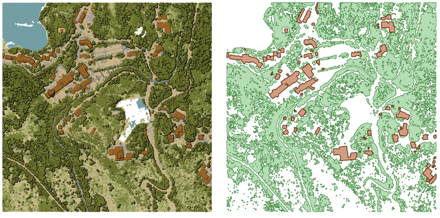
28.16. ábra Extracting high vegetation and building polygons from an input point cloud layer
Paraméterek
Alapvető paraméterek
Címke |
Név |
Típus |
Leírás |
|---|---|---|---|
Input réteg |
|
[point cloud] |
Input point cloud layer to calculate boundary for |
Resolution of cells used to calculate boundary Optional |
|
[szám] |
Resolution of cells used to calculate boundary |
Minimal number of points in a cell to consider cell occupied Optional |
|
[szám] |
Minimal number of points in a cell to consider cell occupied |
Boundary |
|
[vector: polygon] Alapértelmezett: |
Specify the point cloud file to use as output. One of:
|
Speciális paraméterek
Címke |
Név |
Típus |
Leírás |
|---|---|---|---|
Filter expression Optional |
|
[expression] |
A PDAL expression for selecting a subset of features in the point cloud data |
Cropping extent Optional |
|
[terjedelem] |
A map extent for selecting a subset of features in the point cloud data Available methods are:
|
Eredmények
Címke |
Név |
Típus |
Leírás |
|---|---|---|---|
Boundary |
|
[vector: polygon] |
Output polygon vector layer with the point cloud boundary.
Currently supported format is |
Python kód
Algorithm ID: pdal:boundary
import processing
processing.run("algorithm_id", {parameter_dictionary})
Az algoritmus azonosító akkor jelenik meg, ha az egérmutatót az algoritmus fölé viszi a Feldolgozás eszköztáron. A paraméterszótár tartalmazza a paraméter NAME-eket és érékeket. A feldolgozási algoritmusok Python konzolról történő futtatásával kapcsolatos részletekért lásd a Using processing algorithms from the console fejezetet.
28.1.14.2. Density
Exports a raster file based on the number of points within each raster cell - useful for quality checking of point cloud datasets.
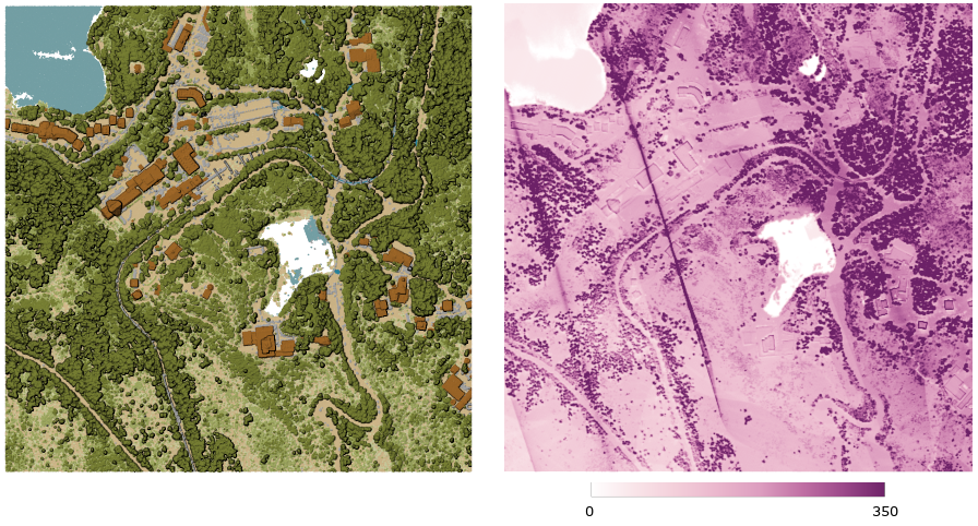
28.17. ábra Point density (number of points per 2x2 m) as a raster
Paraméterek
Alapvető paraméterek
Címke |
Név |
Típus |
Leírás |
|---|---|---|---|
Input réteg |
|
[point cloud] |
Input point cloud layer to export |
Resolution of the density raster |
|
[szám] Default: 1.0 |
Cell size of the output raster |
Tile size for parallel runs |
|
[szám] Default: 1000 |
Size of the tiles to split the data into for parallel runs |
Density |
|
[raster] Alapértelmezett: |
Specify the raster file to export the data to. One of:
|
Speciális paraméterek
Címke |
Név |
Típus |
Leírás |
|---|---|---|---|
Filter expression Optional |
|
[expression] |
A PDAL expression for selecting a subset of features in the point cloud data |
Cropping extent Optional |
|
[terjedelem] |
A map extent for selecting a subset of features in the point cloud data Available methods are:
|
X origin of a tile for parallel runs Optional |
|
[szám] |
|
Y origin of a tile for parallel runs Optional |
|
[szám] |
Eredmények
Címke |
Név |
Típus |
Leírás |
|---|---|---|---|
Density |
|
[raster] |
Output raster layer with number of points within each cell.
Currently supported format is |
Python kód
Algorithm ID: pdal:density
import processing
processing.run("algorithm_id", {parameter_dictionary})
Az algoritmus azonosító akkor jelenik meg, ha az egérmutatót az algoritmus fölé viszi a Feldolgozás eszköztáron. A paraméterszótár tartalmazza a paraméter NAME-eket és érékeket. A feldolgozási algoritmusok Python konzolról történő futtatásával kapcsolatos részletekért lásd a Using processing algorithms from the console fejezetet.
28.1.14.3. filter
Extracts point from the input point cloud which match PDAL expression and/or are inside of a cropping rectangle.
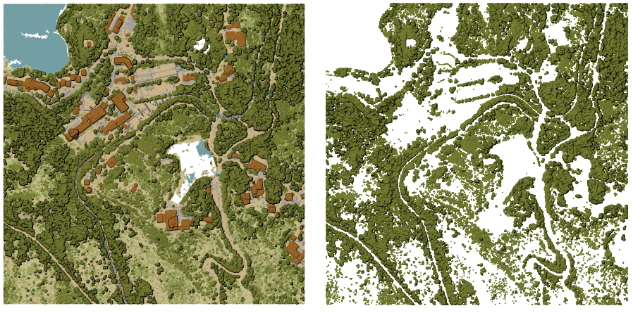
28.18. ábra Filtering of high vegetation class from an input point cloud layer
Paraméterek
Címke |
Név |
Típus |
Leírás |
|---|---|---|---|
Input réteg |
|
[point cloud] |
Input point cloud layer to export |
Filter expression Optional |
|
[expression] |
A PDAL expression for selecting a subset of features in the point cloud data |
Cropping extent Optional |
|
[terjedelem] |
A map extent for selecting a subset of features in the point cloud data Available methods are:
|
Filtered |
|
[point cloud] Alapértelmezett: |
Specify the point cloud file to export the data to. One of:
|
Eredmények
Címke |
Név |
Típus |
Leírás |
|---|---|---|---|
Filtered |
|
[point cloud] |
Output point cloud layer with the filtered features of the input point cloud layer.
Currently supported formats are |
Python kód
Algorithm ID: pdal:filter
import processing
processing.run("algorithm_id", {parameter_dictionary})
Az algoritmus azonosító akkor jelenik meg, ha az egérmutatót az algoritmus fölé viszi a Feldolgozás eszköztáron. A paraméterszótár tartalmazza a paraméter NAME-eket és érékeket. A feldolgozási algoritmusok Python konzolról történő futtatásával kapcsolatos részletekért lásd a Using processing algorithms from the console fejezetet.