Svarbu
Vertimas yra bendruomenės pastangos, prie kurių jūs galite prisijungti. Šis puslapis šiuo metu išverstas 75.92%.
24.1.27. Vektorių persidengimai
24.1.27.1. Apkirpti
Apkerpa vektorinį sluoksnį naudojant geoobjektus iš papildomo poligonų sluoksnio.
Į rezultatų sluoksnį bus įtrauktos tik tos pradinio sluoksnio geoobjektų dalys, kurios patenka į persidengimo sluoksnio poligonus.
Įspėjimas
Keičiama tik geometrija
Šis veiksmas keičia tik geoobjekto geometriją. Geoobjektų atributų reikšmės nekeičiamos, nors geoobjektų savybės, tokios kaip plotas ar ilgis, gali pasikeisti. Jei šios savybės laikomos atributuose, juos reikės pakeisti rankiniu būdu.
Šis algoritmas naudoja tiekėjų erdvinius indeksus, paruoštas geometrijas ir apkarpymo veiksmą taiko tik jei geometrija nepatenka pilnai į slėpimo geometriją.
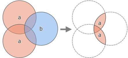
Fig. 24.162 Karpymo veiksmas su dviejų geoobjektų įvesties sluoksniu „a“ ir vieno geoobjekto perdengimo sluoksniu „b“ (kairėje) - gaunamas naujas sluoksnis su pakeistais „a“ geoobjektais (dešinėje)
 Leidžia taškų, linijų ir poligonų geoobjektus keisti vietoje
Numatytas meniu:
Taip pat žiūrėkite
Parametrai
Užrašas |
Pavadinimas |
Tipas |
Aprašymas |
|---|---|---|---|
Įvesties sluoksnis |
|
[vektorius: geometrija] |
Sluoksnis su apkerpamais geoobjektais |
Perdengimo sluoksnis |
|
[vektorius: poligonas] |
Sluoksnis su apkirpimo geoobjektais |
Apkirpta |
|
[toks pat, kaip įvestis] Numatytas: |
Nurodykite sluoksnį, kuriame turės būti įvesties sluoksnio geoobjektai, kurie yra perdangos (apkarpymo) sluoksnio viduje. Vienas iš:
Čia taipogi galima pakeisti failo koduotę. |
Išvestys
Užrašas |
Pavadinimas |
Tipas |
Aprašymas |
|---|---|---|---|
Apkirpta |
|
[toks pat, kaip įvestis] |
Sluoksnis su geoobjektais iš įvesties sluoksnio, padalintais perdengimo sluoksniu. |
Pythono kodas
Algorithm ID: native:clip
import processing
processing.run("algorithm_id", {parameter_dictionary})
algoritmo id rodomas, kai užvedate pelę virš algoritmo apdorojimo įrankinėje. parametrų žodynas teikia parametrų pavadinimus ir reikšmes. Daugiau informacijos apie tai, kaip vykdyti apdorojimo algoritmus Pythono konsolėje rasite skyriuje Using processing algorithms from the console.
24.1.27.2. Skirtumas
Ištraukia iš įvesties sluoksnio geoobjektus, kurie nepatenka į persidengimo sluoksnio ribas.
Įvesties sluoksnio geoobjektai, kurie dalinai kertasi su persidengimo sluoksnio geoobjektu(ais) padalinami pagal tų objektų ribą ir paliekamos tik tos dalys, kurios yra už persidengimo sluoksnio objektų.
Įspėjimas
Keičiama tik geometrija
Šis veiksmas keičia tik geoobjekto geometriją. Geoobjektų atributų reikšmės nekeičiamos, nors geoobjektų savybės, tokios kaip plotas ar ilgis, gali pasikeisti. Jei šios savybės laikomos atributuose, juos reikės pakeisti rankiniu būdu.
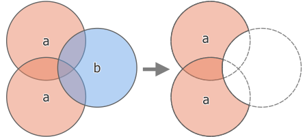
Fig. 24.163 Skirtumo veiksmas su dviem geoobjektais įvesties sluoksnyje „a“ ir vienu geoobjektu persidengimo sluoksnyje „b“ (kairėje) - gaunamas naujas sluoksnis su modifikuotais „a“ geoobjektais (dešinėje)
Leidžia taškų, linijų ir poligonų geoobjektus keisti vietoje
Numatytas meniu:
Taip pat žiūrėkite
Parametrai
Baziniai parametrai
Užrašas |
Pavadinimas |
Tipas |
Aprašymas |
|---|---|---|---|
Įvesties sluoksnis |
|
[vektorius: geometrija] |
Sluoksnis, iš kurio reikia ištraukti geoobjektus (ar jų dalis). |
Perdengimo sluoksnis |
|
[vektorius: geometrija] |
Sluoksnis su geometrijomis, kurios bus atimamos iš įvesties sluoksnio geometrijų. Tikimasi, kad jame bus bent tiek matmenų (taškai: 0D, linijos: 1D, poligonai: 2D, tūris: 3D), kiek įvesties sluoksnio geometrijose. |
Skirtumas |
|
[toks pat, kaip įvestis] Numatytas: |
Nurodykite sluoksnį, kuriame turės būti įvesties sluoksnio geoobjektai (jų dalys), kurie nėra perdangos (apkarpymo) sluoksnio viduje. Vienas iš:
Čia taipogi galima pakeisti failo koduotę. |
Išmanesni parametrai
Užrašas |
Pavadinimas |
Tipas |
Aprašymas |
|---|---|---|---|
Tinklelio dydis Pasirinktinis |
|
[skaičius: slankaus kablelio] Numatytas: jokio |
If provided, the input geometries are snapped to a grid of the given size, and the result vertices are computed on that same grid. |
Išvestys
Užrašas |
Pavadinimas |
Tipas |
Aprašymas |
|---|---|---|---|
Skirtumas |
|
[toks pat, kaip įvestis] |
Sluoksnis su geoobjektais (ar jų dalimis) iš įvesties sluoksnio, nepersidengiančiais su persidengimo sluoksniu. |
Pythono kodas
Algorithm ID: native:difference
import processing
processing.run("algorithm_id", {parameter_dictionary})
algoritmo id rodomas, kai užvedate pelę virš algoritmo apdorojimo įrankinėje. parametrų žodynas teikia parametrų pavadinimus ir reikšmes. Daugiau informacijos apie tai, kaip vykdyti apdorojimo algoritmus Pythono konsolėje rasite skyriuje Using processing algorithms from the console.
24.1.27.3. Skirtumas (keli)
Ištraukia išvesties sluoksnio geoobjektus, kurie yra pilnai už arba dalinai dengia persidengimo sluoksnio(ių) geoobjektus.
Skirtumas kiekvienam persidengimo sluoksniui skaičiuojamas tarp visų ankstesnių skirtumo veiksmų rezultato ir perdangos sluoksnio. Įvesties sluoksnių geoobjektai, kurie dalinai dengia geoobjektą(us) perdengimo sluoksnyje, padalinami ties tų geoobjektų riba ir tik paliekamos tik tos jų dalys, kurios yra už perdengimo sluoksnio geoobjektų.
Įspėjimas
Keičiama tik geometrija
Šis veiksmas keičia tik geoobjekto geometriją. Geoobjektų atributų reikšmės nekeičiamos, nors geoobjektų savybės, tokios kaip plotas ar ilgis, gali pasikeisti. Jei šios savybės laikomos atributuose, juos reikės pakeisti rankiniu būdu.
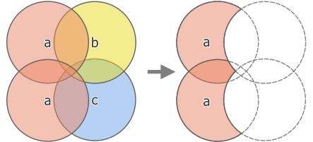
Fig. 24.164 Skirtumo veiksmas tarp dviejų geoobjektų įvesties sluoksnio „a“ ir vieno geoobjekto perdengimo sluoksnių „b“ ir „c“ (kairėje) - gauname nauje sluoksnį su pakeistais „a“ geoobjektais (dešinėje)
Taip pat žiūrėkite
Parametrai
Užrašas |
Pavadinimas |
Tipas |
Aprašymas |
|---|---|---|---|
Įvesties sluoksnis |
|
[vektorius: geometrija] |
Sluoksnis, iš kurio reikia ištraukti geoobjektus (ar jų dalis). |
Perdengimo sluoksniai |
|
[vektorius: geometrija] [sąrašas] |
Sąrašas sluoksnų su geometrijomis, kurios bus atimamos iš įvesties sluoksnio geometrijų. Tikimasi, kad juose bus bent tiek matmenų (taškai: 0D, linijos: 1D, poligonai: 2D, tūris: 3D), kiek įvesties sluoksnio geometrijose. |
Skirtumas |
|
[toks pat, kaip įvestis] Numatytas: |
Nurodykite sluoksnį, kuriame bus įvesties sluoksnio geoobjektai (ar jų dalys), kurie nesidengia su persidengimo sluoksnių geoobjektais. Vienas iš:
Čia taipogi galima pakeisti failo koduotę. |
Išvestys
Užrašas |
Pavadinimas |
Tipas |
Aprašymas |
|---|---|---|---|
Skirtumas |
|
[toks pat, kaip įvestis] |
Sluoksnis su įvesties sluoksnio geoobjektais (ar jų dalimis), kurie nesidengia su persidengimo sluoksnio geoobjektais. |
Pythono kodas
Algorithm ID: native:multidifference
import processing
processing.run("algorithm_id", {parameter_dictionary})
algoritmo id rodomas, kai užvedate pelę virš algoritmo apdorojimo įrankinėje. parametrų žodynas teikia parametrų pavadinimus ir reikšmes. Daugiau informacijos apie tai, kaip vykdyti apdorojimo algoritmus Pythono konsolėje rasite skyriuje Using processing algorithms from the console.
24.1.27.4. Extract/clip by extent
Creates a new vector layer that only contains features which fall within a specified extent. Any features which intersect the extent will be included by default.
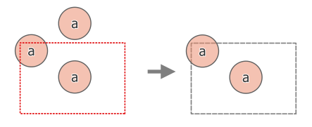
Fig. 24.165 Extract operation between a three-feature input layer ‚a‘ and a dashed extent (left) - resulting features with dashed extent for reference (right)
Optionally, feature geometries can also be clipped to the extent.
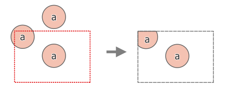
Fig. 24.166 Extract operation between a three-feature input layer ‚a‘ and a dashed extent (left) - resulting features with dashed extent for reference (right)
Taip pat žiūrėkite
Parametrai
Užrašas |
Pavadinimas |
Tipas |
Aprašymas |
|---|---|---|---|
Įvesties sluoksnis |
|
[vektorius: geometrija] |
Sluoksnis, iš kurio reikia ištraukti geoobjektus (ar jų dalis). |
Apimtis (xmin, xmax, ymin, ymax) |
|
[apimtis] |
Extent for clipping. Galimi metodai yra:
|
Clip features to extent |
|
[boolean] Numatytas: ne |
If checked, the geometries will be clipped to the extent chosen instead of taking the whole geometry as output. Moreover, output geometries will be automatically converted to multi geometries to ensure uniform output types. |
Extracted |
|
[toks pat, kaip įvestis] Numatytas: |
Specify the layer to contain the features from the input layer that are inside the clip extent. One of:
Čia taipogi galima pakeisti failo koduotę. |
Išvestys
Užrašas |
Pavadinimas |
Tipas |
Aprašymas |
|---|---|---|---|
Extracted |
|
[toks pat, kaip įvestis] |
Layer containing the clipped features. |
Pythono kodas
Algorithm ID: native:extractbyextent
import processing
processing.run("algorithm_id", {parameter_dictionary})
algoritmo id rodomas, kai užvedate pelę virš algoritmo apdorojimo įrankinėje. parametrų žodynas teikia parametrų pavadinimus ir reikšmes. Daugiau informacijos apie tai, kaip vykdyti apdorojimo algoritmus Pythono konsolėje rasite skyriuje Using processing algorithms from the console.
24.1.27.5. Intersection
Extracts the portions of features from the input layer that overlap features in the overlay layer.
Features in the intersection layer are assigned the attributes of the overlapping features from both the input and overlay layers.
Įspėjimas
Keičiama tik geometrija
Šis veiksmas keičia tik geoobjekto geometriją. Geoobjektų atributų reikšmės nekeičiamos, nors geoobjektų savybės, tokios kaip plotas ar ilgis, gali pasikeisti. Jei šios savybės laikomos atributuose, juos reikės pakeisti rankiniu būdu.
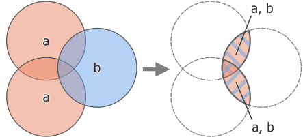
Fig. 24.167 Intersection operation between a two-feature input layer ‚a‘ and a single feature overlay layer ‚b‘ (left) - overlapping areas become a new two-feature layer with both layers‘ attributes (right)
Numatytas meniu:
Įspėjimas
Šis algoritmas išmeta esamus pirminius raktus ar FID reikšmes ir perkuria jas išvesties sluoksniuose.
Taip pat žiūrėkite
Parametrai
Baziniai parametrai
Užrašas |
Pavadinimas |
Tipas |
Aprašymas |
|---|---|---|---|
Įvesties sluoksnis |
|
[vektorius: geometrija] |
Sluoksnis, iš kurio reikia ištraukti geoobjektus (ar jų dalis). |
Perdengimo sluoksnis |
|
[vektorius: geometrija] |
Layer containing the features to check for overlap. Its features‘ geometry is expected to have at least as many dimensions (point: 0D, line: 1D, polygon: 2D, volume: 3D) as the input layer’s. |
Input fields to keep (leave empty to keep all fields) Pasirinktinis |
|
[lentelės laukas: bet koks] [sąrašas] Numatytas: jokio |
Field(s) of the input layer to keep in the output. If no fields are chosen all fields are taken. |
Overlay fields to keep (leave empty to keep all fields) Pasirinktinis |
|
[lentelės laukas: bet koks] [sąrašas] Numatytas: jokio |
Field(s) of the overlay layer to keep in the output. If no fields are chosen all fields are taken. Duplicate field names will be appended a count suffix to avoid collision. |
Intersection |
|
[toks pat, kaip įvestis] Numatytas: |
Specify the layer to contain (the parts of) the features from the input layer that overlap one or more features from the overlay layer. One of:
Čia taipogi galima pakeisti failo koduotę. |
Išmanesni parametrai
Užrašas |
Pavadinimas |
Tipas |
Aprašymas |
|---|---|---|---|
Overlay fields prefix Pasirinktinis |
|
[tekstas] |
Add a prefix to identify fields of the overlay layer. Duplicate field names will be appended a count suffix to avoid collision. |
Tinklelio dydis Pasirinktinis |
|
[skaičius: slankaus kablelio] Numatytas: jokio |
If provided, the input geometries are snapped to a grid of the given size, and the result vertices are computed on that same grid. |
Išvestys
Užrašas |
Pavadinimas |
Tipas |
Aprašymas |
|---|---|---|---|
Intersection |
|
[toks pat, kaip įvestis] |
Layer containing (parts of) features from the input layer that overlap the overlay layer. |
Pythono kodas
Algorithm ID: native:intersection
import processing
processing.run("algorithm_id", {parameter_dictionary})
algoritmo id rodomas, kai užvedate pelę virš algoritmo apdorojimo įrankinėje. parametrų žodynas teikia parametrų pavadinimus ir reikšmes. Daugiau informacijos apie tai, kaip vykdyti apdorojimo algoritmus Pythono konsolėje rasite skyriuje Using processing algorithms from the console.
24.1.27.6. Intersection (multiple)
Extracts the overlapping portions of features in the input and all overlay layers.
Features in the output layer are assigned the attributes of the overlapping features from both the input and overlay layers.
Įspėjimas
Keičiama tik geometrija
Šis veiksmas keičia tik geoobjekto geometriją. Geoobjektų atributų reikšmės nekeičiamos, nors geoobjektų savybės, tokios kaip plotas ar ilgis, gali pasikeisti. Jei šios savybės laikomos atributuose, juos reikės pakeisti rankiniu būdu.
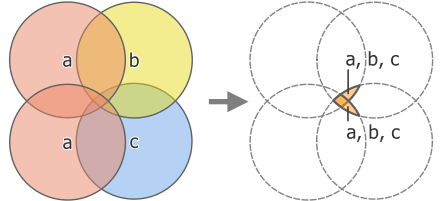
Fig. 24.168 Intersection operation between a two-feature input layer ‚a‘ and single feature overlay layers ‚b‘ and ‚c‘ (left) - overlapping areas become a new two-feature layer with all layers‘ attributes (right)
Įspėjimas
This algorithm drops existing primary keys or FID values and regenerate them in output layers.
Taip pat žiūrėkite
Parametrai
Baziniai parametrai
Užrašas |
Pavadinimas |
Tipas |
Aprašymas |
|---|---|---|---|
Įvesties sluoksnis |
|
[vektorius: geometrija] |
Sluoksnis, iš kurio reikia ištraukti geoobjektus (ar jų dalis). |
Perdengimo sluoksniai |
|
[vektorius: geometrija] [sąrašas] |
Layers containing the features to check for overlap. The features‘ geometry is expected to have at least as many dimensions (point: 0D, line: 1D, polygon: 2D, volume: 3D) as the input layer’s. |
Išmanesni parametrai
Užrašas |
Pavadinimas |
Tipas |
Aprašymas |
|---|---|---|---|
Overlay fields prefix Pasirinktinis |
|
[tekstas] |
Add a prefix to identify fields of the overlay layers. Duplicate field names will be appended a count suffix to avoid collision. |
Išvestys
Užrašas |
Pavadinimas |
Tipas |
Aprašymas |
|---|---|---|---|
Intersection |
|
[toks pat, kaip įvestis] |
Layer containing (parts of) features from the input layer that overlap all the overlay layers. |
Pythono kodas
Algorithm ID: native:multiintersection
import processing
processing.run("algorithm_id", {parameter_dictionary})
algoritmo id rodomas, kai užvedate pelę virš algoritmo apdorojimo įrankinėje. parametrų žodynas teikia parametrų pavadinimus ir reikšmes. Daugiau informacijos apie tai, kaip vykdyti apdorojimo algoritmus Pythono konsolėje rasite skyriuje Using processing algorithms from the console.
24.1.27.7. Line intersections
Creates point features where the lines from the two layers intersect.
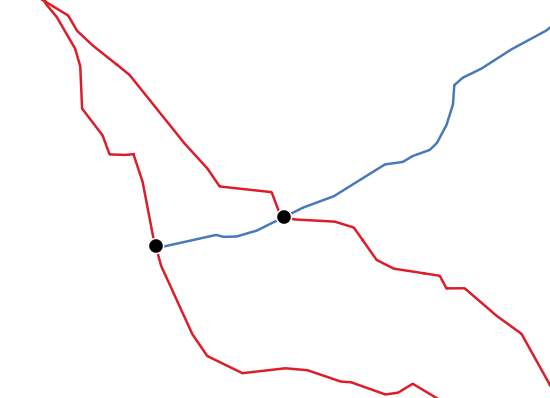
Fig. 24.169 Points of intersection
Numatytas meniu:
Įspėjimas
This algorithm drops existing primary keys or FID values and regenerate them in output layers.
Parametrai
Baziniai parametrai
Užrašas |
Pavadinimas |
Tipas |
Aprašymas |
|---|---|---|---|
Įvesties sluoksnis |
|
[vektorius: linija] |
Input line layer. |
Intersect layer |
|
[vektorius: linija] |
Layer to use to find line intersections. |
Input fields to keep (leave empty to keep all fields) Pasirinktinis |
|
[lentelės laukas: bet koks] [sąrašas] Numatytas: jokio |
Field(s) of the input layer to keep in the output. If no fields are chosen all fields are taken. |
Intersect fields to keep (leave empty to keep all fields) Pasirinktinis |
|
[lentelės laukas: bet koks] [sąrašas] Numatytas: jokio |
Field(s) of the intersect layer to keep in the output. If no fields are chosen all fields are taken. Duplicate field names will be appended a count suffix to avoid collision. |
Intersection |
|
[vektorius: taškas] Numatytas: |
Specify the layer to contain the intersection points of the lines from the input and overlay layers. One of:
Čia taipogi galima pakeisti failo koduotę. |
Išmanesni parametrai
Užrašas |
Pavadinimas |
Tipas |
Aprašymas |
|---|---|---|---|
Intersect fields prefix Pasirinktinis |
|
[tekstas] |
Add a prefix to identify fields of the intersect layer. |
Išvestys
Užrašas |
Pavadinimas |
Tipas |
Aprašymas |
|---|---|---|---|
Intersections |
|
[vektorius: taškas] |
Point vector layer of the lines intersections, with both layers‘ attributes. |
Pythono kodas
Algorithm ID: native:lineintersections
import processing
processing.run("algorithm_id", {parameter_dictionary})
algoritmo id rodomas, kai užvedate pelę virš algoritmo apdorojimo įrankinėje. parametrų žodynas teikia parametrų pavadinimus ir reikšmes. Daugiau informacijos apie tai, kaip vykdyti apdorojimo algoritmus Pythono konsolėje rasite skyriuje Using processing algorithms from the console.
24.1.27.8. Split with lines
Splits the lines or polygons in one layer using the lines or polygon rings in another layer to define the breaking points. Intersection between geometries in both layers are considered as split points.
Output will contain multi geometries for split features.
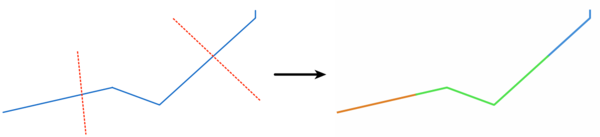
Fig. 24.170 Split lines
Allows features in-place modification
of line and polygon features
Įspėjimas
This algorithm drops existing primary keys or FID values and regenerate them in output layers.
Parametrai
Užrašas |
Pavadinimas |
Tipas |
Aprašymas |
|---|---|---|---|
Įvesties sluoksnis |
|
[vektorius: linija, poligonas] |
Layer containing the lines or polygons to split. |
Split layer |
|
[vektorius: linija, poligonas] |
Layer whose lines or rings are used to define the breaking points. |
Split |
|
[toks pat, kaip įvestis] Numatytas: |
Specify the layer to contain the split (in case they are intersected by a line in the split layer) line/polygon features from the input layer. One of:
Čia taipogi galima pakeisti failo koduotę. |
Išvestys
Užrašas |
Pavadinimas |
Tipas |
Aprašymas |
|---|---|---|---|
Split |
|
[toks pat, kaip įvestis] |
Output vector layer with split lines or polygons from input layer. |
Pythono kodas
Algorithm ID: native:splitwithlines
import processing
processing.run("algorithm_id", {parameter_dictionary})
algoritmo id rodomas, kai užvedate pelę virš algoritmo apdorojimo įrankinėje. parametrų žodynas teikia parametrų pavadinimus ir reikšmes. Daugiau informacijos apie tai, kaip vykdyti apdorojimo algoritmus Pythono konsolėje rasite skyriuje Using processing algorithms from the console.
24.1.27.9. Symmetrical difference
Creates a layer containing features from both the input and overlay layers but with the overlapping areas between the two layers removed.
The attribute table of the symmetrical difference layer contains attributes and fields from both the input and overlay layers.
Įspėjimas
Keičiama tik geometrija
Šis veiksmas keičia tik geoobjekto geometriją. Geoobjektų atributų reikšmės nekeičiamos, nors geoobjektų savybės, tokios kaip plotas ar ilgis, gali pasikeisti. Jei šios savybės laikomos atributuose, juos reikės pakeisti rankiniu būdu.
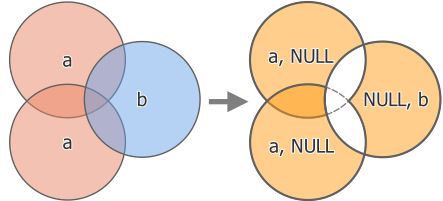
Fig. 24.171 Symmetrical difference operation between a two-features input layer ‚a‘ and a single feature overlay layer ‚b‘ (left) - resulting three-feature layer with both layers‘ attributes (right)
Numatytas meniu:
Įspėjimas
This algorithm drops existing primary keys or FID values and regenerate them in output layers.
Taip pat žiūrėkite
Parametrai
Baziniai parametrai
Užrašas |
Pavadinimas |
Tipas |
Aprašymas |
|---|---|---|---|
Įvesties sluoksnis |
|
[vektorius: geometrija] |
First layer to extract (parts of) features from. |
Perdengimo sluoksnis |
|
[vektorius: geometrija] |
Second layer to extract (parts of) features from. Ideally the geometry type should be the same as input layer. |
Symmetrical difference |
|
[toks pat, kaip įvestis] Numatytas: |
Specify the layer to contain (the parts of) the features from the input and overlay layers that do not overlap features from the other layer. One of:
Čia taipogi galima pakeisti failo koduotę. |
Išmanesni parametrai
Užrašas |
Pavadinimas |
Tipas |
Aprašymas |
|---|---|---|---|
Overlay fields prefix Pasirinktinis |
|
[tekstas] |
Add a prefix to identify fields of the overlay layer. Duplicate field names will be appended a count suffix to avoid collision. |
Tinklelio dydis Pasirinktinis |
|
[skaičius: slankaus kablelio] Numatytas: jokio |
If provided, the input geometries are snapped to a grid of the given size, and the result vertices are computed on that same grid. |
Išvestys
Užrašas |
Pavadinimas |
Tipas |
Aprašymas |
|---|---|---|---|
Symmetrical difference |
|
[toks pat, kaip įvestis] |
Layer containing (parts of) features from each layer not overlapping the other layer, with both layers‘ attributes. |
Pythono kodas
Algorithm ID: native:symmetricaldifference
import processing
processing.run("algorithm_id", {parameter_dictionary})
algoritmo id rodomas, kai užvedate pelę virš algoritmo apdorojimo įrankinėje. parametrų žodynas teikia parametrų pavadinimus ir reikšmes. Daugiau informacijos apie tai, kaip vykdyti apdorojimo algoritmus Pythono konsolėje rasite skyriuje Using processing algorithms from the console.
24.1.27.10. Union
Checks overlaps between features within the input layer and creates separate features for overlapping and non-overlapping parts. The area of overlap will create as many identical overlapping features as there are features that participate in that overlap.
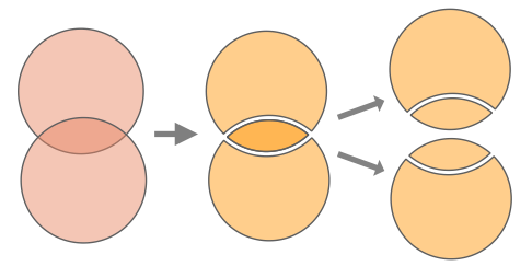
Fig. 24.172 Union operation with a single input layer with two overlapping features (left) - resulting in four features (middle) - features moved for clarity (right)
An overlay layer can also be used, in which case features from each layer are split at their overlap with features from the other one, creating a layer containing all the portions from both input and overlay layers. Features on the same layer will not split each other. The attribute table of the union layer is filled with attribute values from the respective original layer for non-overlapping features, and attribute values from both layers for overlapping features.
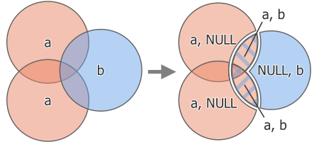
Fig. 24.173 Union operation between a two-feature input layer ‚a‘ and a single feature overlay layer ‚b‘ (left) - resulting five-feature layer with attributes from both layers (right)
Pastaba
With an overlay layer, features on the same layer will not split each other. If you want to split overlaps on the same layer as well as other layers, first run the algorithm with multiple layers then run the algorithm again with only the previous output.
Numatytas meniu:
Įspėjimas
This algorithm drops existing primary keys or FID values and regenerate them in output layers.
Taip pat žiūrėkite
Parametrai
Baziniai parametrai
Užrašas |
Pavadinimas |
Tipas |
Aprašymas |
|---|---|---|---|
Įvesties sluoksnis |
|
[vektorius: geometrija] |
Input vector layer to split at any intersections. |
Perdengimo sluoksnis Pasirinktinis |
|
[vektorius: geometrija] |
Layer that will be combined to the first one. Ideally the geometry type should be the same as input layer. |
Union |
|
[toks pat, kaip įvestis] Numatytas: |
Specify the layer to contain the (split and duplicated) features from the input layer and the overlay layer. One of:
Čia taipogi galima pakeisti failo koduotę. |
Išmanesni parametrai
Užrašas |
Pavadinimas |
Tipas |
Aprašymas |
|---|---|---|---|
Overlay fields prefix Pasirinktinis |
|
[tekstas] |
Add a prefix to identify fields of the overlay layer. Duplicate field names will be appended a count suffix to avoid collision. |
Tinklelio dydis Pasirinktinis |
|
[skaičius: slankaus kablelio] Numatytas: jokio |
If provided, the input geometries are snapped to a grid of the given size, and the result vertices are computed on that same grid. |
Išvestys
Užrašas |
Pavadinimas |
Tipas |
Aprašymas |
|---|---|---|---|
Union |
|
[toks pat, kaip įvestis] |
Layer containing all the overlapping and non-overlapping parts from the processed layer(s). |
Pythono kodas
Algorithm ID: native:union
import processing
processing.run("algorithm_id", {parameter_dictionary})
algoritmo id rodomas, kai užvedate pelę virš algoritmo apdorojimo įrankinėje. parametrų žodynas teikia parametrų pavadinimus ir reikšmes. Daugiau informacijos apie tai, kaip vykdyti apdorojimo algoritmus Pythono konsolėje rasite skyriuje Using processing algorithms from the console.
24.1.27.11. Union (multiple)
Checks overlaps between features within the input layer and creates separate features for overlapping and non-overlapping parts. The area of overlap will create as many identical overlapping features as there are features that participate in that overlap.
Fig. 24.174 Union operation with a single input layer with two overlapping features (left) - resulting in four features (middle) - features moved for clarity (right)
Multiple overlay layers can also be used, in which case features from each layer are split at their overlap with features from all other layers, creating a layer containing all the portions from both input and overlay layers. Features on the same layer will not split each other. The attribute table of the Union layer is filled with attribute values from the respective original layer for non-overlapping features, and attribute values from overlay layers for overlapping features.
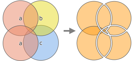
Fig. 24.175 Union operation between a two-feature input layer ‚a‘ and single feature overlay layers ‚b‘ and ‚c‘ (left) - resulting eleven-feature layer with attributes from all layers (right)
Pastaba
With an overlay layer, features on the same layer will not split each other. If you want to split overlaps on the same layer as well as other layers, first run the algorithm with multiple layers then run the algorithm again with only the previous output.
Įspėjimas
This algorithm drops existing primary keys or FID values and regenerate them in output layers.
Taip pat žiūrėkite
Parametrai
Baziniai parametrai
Užrašas |
Pavadinimas |
Tipas |
Aprašymas |
|---|---|---|---|
Įvesties sluoksnis |
|
[vektorius: geometrija] |
Input vector layer to split at any intersections. |
Perdengimo sluoksniai Pasirinktinis |
|
[vektorius: geometrija] [sąrašas] |
Layers that will be combined to the first one. Ideally the geometry type should be the same as input layer. |
Union |
|
[toks pat, kaip įvestis] Numatytas: |
Specify the layer to contain the (split and duplicated) features from the input layer and the overlay layers. One of:
Čia taipogi galima pakeisti failo koduotę. |
Išmanesni parametrai
Užrašas |
Pavadinimas |
Tipas |
Aprašymas |
|---|---|---|---|
Overlay fields prefix Pasirinktinis |
|
[tekstas] |
Add a prefix to identify fields of the overlay layers. Duplicate field names will be appended a count suffix to avoid collision. |
Išvestys
Užrašas |
Pavadinimas |
Tipas |
Aprašymas |
|---|---|---|---|
Union |
|
[toks pat, kaip įvestis] |
Layer containing all the overlapping and non-overlapping parts from the processed layer(s), with all layers‘ attributes. |
Pythono kodas
Algorithm ID: native:multiunion
import processing
processing.run("algorithm_id", {parameter_dictionary})
algoritmo id rodomas, kai užvedate pelę virš algoritmo apdorojimo įrankinėje. parametrų žodynas teikia parametrų pavadinimus ir reikšmes. Daugiau informacijos apie tai, kaip vykdyti apdorojimo algoritmus Pythono konsolėje rasite skyriuje Using processing algorithms from the console.