Ważne
Tłumaczenie jest wysiłkiem społeczności QGISa przyłącz się. Ta strona jest obecnie przetłumaczona w 70.54%.
3.4. Web Coverage Service (WCS)
The 1.0.0 and 1.1.1 WCS standards implemented in QGIS Server provide a HTTP interface to access raster data, referred to as coverage, coming from a QGIS project.
Specyfikacje:
Standardowe żądania dostarczane przez QGIS Server :
Zapytanie |
Opis |
|---|---|
Zwraca metadane XML zawierające informacje o serwerze |
|
Retrieves XML document about additional information about coverages |
|
Retrieves coverage |
3.4.1. GetCapabilities
Standard parameters for the GetCapabilities request according to the OGC WCS 1.1.1 specifications:
Parametr |
Wymagany |
Opis |
|---|---|---|
Tak |
Name of the service (WCS) |
|
Tak |
Nazwa zapytania (GetCapabilities) |
|
Nie |
Version of the service |
Oprócz standardowych parametrów, QGIS Server obsługuje następujące parametry dodatkowe:
Parametr |
Wymagany |
Opis |
|---|---|---|
Tak |
Plik projektu QGIS |
Przykład URL:
http://localhost/qgisserver?
SERVICE=WCS
&VERSION=1.1.1
&REQUEST=GetCapabilities
XML document example when a single raster layer (named
T20QPD_20171123T144719_TCI) is published in the QGIS project for the WCS
service:
<WCS_Capabilities xmlns="http://www.opengis.net/wcs" xmlns:xlink="http://www.w3.org/1999/xlink" xmlns:gml="http://www.opengis.net/gml" xmlns:xsi="http://www.w3.org/2001/XMLSchema-instance" version="1.0.0" updateSequence="0" xsi:schemaLocation="http://www.opengis.net/wcs http://schemas.opengis.net/wcs/1.0.0/wcsCapabilities.xsd">
  <Service>
    ...
  </Service>
  <Capability>
    ...
  </Capability>
  <ContentMetadata>
    <CoverageOfferingBrief>
      <name>T20QPD_20171123T144719_TCI</name>
      <label>T20QPD_20171123T144719_TCI</label>
      <lonLatEnvelope srsName="urn:ogc:def:crs:OGC:1.3:CRS84">
        <gml:pos>-61.585973 16.331189</gml:pos>
        <gml:pos>-61.52537 16.400376</gml:pos>
      </lonLatEnvelope>
    </CoverageOfferingBrief>
  </ContentMetadata>
</WCS_Capabilities>
VERSION
This parameter allows to specify the version of the service to use. Currently,
the version values is not internally used and always fallback to 1.1.1.
3.4.2. DescribeCoverage
This request allows to retrieve additional information about coverages like the format of the underlying datasource, the number of bands, … Standard parameters for the DescribeCoverage request according to the OGC WCS 1.1.1 specifications:
Parametr |
Wymagany |
Opis |
|---|---|---|
Tak |
Name of the service (WCS) |
|
Tak |
Name of the request (DescribeCoverage) |
|
Nie |
Version of the service |
|
Nie |
Specify coverage layers (WCS 1.0.0) |
|
Nie |
Specify coverage layers (WCS 1.1.1) |
Oprócz standardowych parametrów, QGIS Server obsługuje następujące parametry dodatkowe:
Parametr |
Wymagany |
Opis |
|---|---|---|
Tak |
Plik projektu QGIS |
The XML document for a 3 bands GeoTIFF raster layer looks like:
<CoverageDescription xmlns:xlink="http://www.w3.org/1999/xlink" xmlns="http://www.opengis.net/wcs" xmlns:gml="http://www.opengis.net/gml" xmlns:xsi="http://www.w3.org/2001/XMLSchema-instance" updateSequence="0" version="1.0.0" xsi:schemaLocation="http://www.opengis.net/wcs http://schemas.opengis.net/wcs/1.0.0/describeCoverage.xsd">
  <CoverageOffering>
    <name>T20QPD_20171123T144719_TCI</name>
    <label>T20QPD_20171123T144719_TCI</label>
    <lonLatEnvelope srsName="urn:ogc:def:crs:OGC:1.3:CRS84">
      ...
    </lonLatEnvelope>
    <domainSet>
      ...
    </domainSet>
    <rangeSet>
      <RangeSet>
        <name>Bands</name>
        <label>Bands</label>
        <axisDescription>
          <AxisDescription>
            <name>bands</name>
            <label>bands</label>
            <values>
              <singleValue>1</singleValue>
              <singleValue>2</singleValue>
              <singleValue>3</singleValue>
            </values>
          </AxisDescription>
        </axisDescription>
      </RangeSet>
    </rangeSet>
    <supportedCRSs>
    ...
    </supportedCRSs>
    <supportedFormats nativeFormat="raw binary">
      <formats>GeoTIFF</formats>
    </supportedFormats>
  </CoverageOffering>
</CoverageDescription>
COVERAGE
This parameter, defined in WCS 1.0.0, allows to specify the layers to query
for additional information. Names have to be separated by a comma.
In addition, QGIS Server introduced an option to select layers by its short name. The short name of a layer may be configured through in layer menu. If the short name is defined, then it’s used by default instead of the layer’s name:
http://localhost/qgisserver?
SERVICE=WCS
&REQUEST=DescribeCoverage
&COVERAGE=mylayer1name,mylayer2shortname
Informacja
COVERAGE is mandatory if IDENTIFIER is not set.
IDENTIFIER
This parameter replaces the COVERAGE
parameter in WCS 1.1.1. But QGIS Server does not filter according to the
VERSION parameter so IDENTIFIER and COVERAGE have the same effect.
Informacja
IDENTIFIER is mandatory if COVERAGE is not set. If both
IDENTIFIER and COVERAGE parameters are defined, COVERAGE is
always used in priority.
3.4.3. GetCoverage
This request allows to retrieve the coverage according to specific constraints like the extent or the CRS. Standard parameters for the DescribeCoverage request according to the OGC WCS 1.1.1 specifications:
Parametr |
Wymagany |
Opis |
|---|---|---|
Tak |
Name of the service (WCS) |
|
Tak |
Name of the request (GetCoverage) |
|
Nie |
Version of the service |
|
Nie |
Specify coverage layers (WCS 1.0.0) |
|
Nie |
Specify coverage layers (WCS 1.1.1) |
|
Tak |
Width of the response in pixels |
|
Tak |
Height of the response in pixels |
|
Tak |
Map extent in CRS units |
|
Tak |
Coordinate reference system of the extent |
|
Nie |
Coordinate reference system of the response |
Oprócz standardowych parametrów, QGIS Server obsługuje następujące parametry dodatkowe:
Parametr |
Wymagany |
Opis |
|---|---|---|
Tak |
Plik projektu QGIS |
BBOX
This parameter allows to specify the map extent in the units of the current
CRS. Coordinates have to be separated by a comma. The BBOX parameter is
formed like minx,miny,maxx,maxy.
Przykład URL:
http://localhost/qgisserver?
SERVICE=WCS
&REQUEST=GetCoverage
&IDENTIFIER=T20QPD_20171123T144719_TCI
&BBOX=647533,1805950,660987,1813940
&CRS=EPSG:32620
CRS
This parameter allows to indicate the Spatial Reference System of the BBOX
parameter and has to be formed like EPSG:XXXX.
RESPONSE_CRS
This parameter allows to indicate the output response Spatial Reference System
and has to be formed like EPSG:XXXX. The CRS of the corresponding coverage
layer is used by default.
WIDTH
This parameter allows to specify the width in pixels of the output image. The resolution of the response image depends on this value.
HEIGHT
This parameter allows to specify the height in pixels of the output image. The resolution of the response image depends on this value.
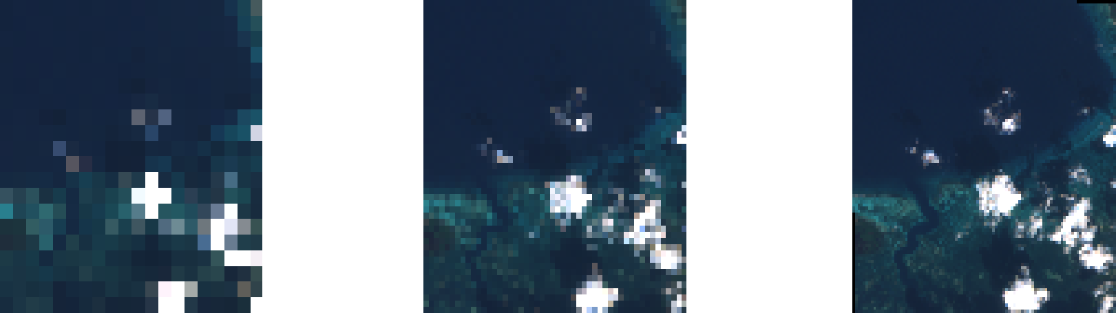
Rys. 3.24 From left to right: WIDTH=20&HEIGHT=20, WIDTH=50&HEIGHT=50, WIDTH=100&HEIGHT=100