18.3. Lesson: Working with SpatiaLite databases in QGIS
While PostGIS is generally used on a server to provide spatial database capabilities to multiple users at the same time, QGIS also supports the use of a file format called SpatiaLite that is a lightweight, portable way to store an entire spatial database in a single file. Obviously, these 2 types of spatial databases should be used for different purposes, but the same basic principles and techniques apply to both. Let's create a new SpatiaLite database and explore the functionality provided to work with these databases in QGIS.
The goal for this lesson: To learn how to interact with SpatiaLite databases using the QGIS Browser interface.
18.3.1.  Follow Along: Creating a SpatiaLite database with the Browser
Using the Browser panel, we can create a new SpatiaLite database and get it setup for use in QGIS.
Right click on the SpatiaLite entry in the Browser tree and select Create Database.
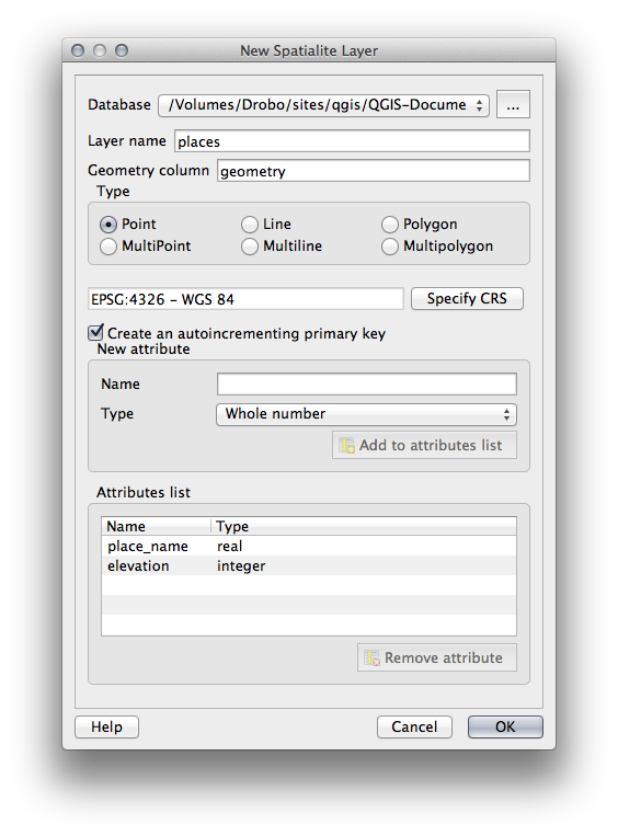
Specify where on your filesystem you want to store the file and name it
qgis-sl.db.Again right click on the SpatiaLite entry in the Browser tree and now select the New Connection item. Find the file you created in the last step and open it.
これでブラウザツリーに新しいデータベースが構成され, その下には何も持たないことから, 行える操作は削除できることだけだということがわかります.このデータベースには何のテーブルも追加していないのでこれは当然です. それでは先に進んでみましょう.
Find the button to create a new layer and use the dropdown to create a new SpatiaLite layer, or select
 .
.前の手順で作成したデータベースをドロップダウン内から選択します.
Give the layer the name
places.次に 自動増分の主キーを作成する のチェックボックスを選択します.
Add two attributes as shown in below
OK をクリックしてテーブルを作成します.
Click the refresh button at the top of the Browser and you should now see your
placestable listed.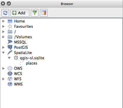
テーブルを右クリックして, 前のレッスンで行ったようにプロパティを表示することができます.
ここから編集のセッションを開始して直接新しいデータベースにデータを追加することができます.
We also learned about how to import data into a database using the DB Manager and you can use this same technique to import data into your new SpatiaLite DB.
18.3.2. In Conclusion
You have seen how to create SpatiaLite databases, add tables to them and use these tables as layers in QGIS.