` `
ジオメトリチェッカープラグイン
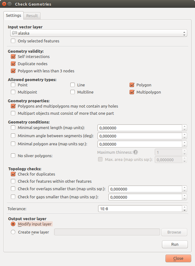
Geometry Checker is a powerful core plugin to check and fix the geometry validity of a layer. The Geometry Checker dialog show differents grouped settings in the first tab (Settings):
- Input vector layer: to select the layer to check. A
 Only selected features checkbox can filter the geometry to the
one selected.
 - Geometry validity: give to the user the choice between Self intersections, Duplicate nodes, Polygon with less than 3 nodes.
可能なジオメトリタイプ :ポイント、マルチポイント、ライン、マルチライン、ポリゴンとマルチポリゴンのようないくつかのジオメトリタイプだけを許可します。
- Geometry properties displays
 Polygons and
multipolygons may not contain any holes and
  Multipart
objects must consist of more than one part.
 ジオメトリ条件 :ユーザーが最小セグメント長、セグメント間の最小角度、最小多角形領域とスライバポリゴン検出と形状を検証するために、いくつかの条件を追加できます。
- Topology checks: checks for duplicates, for features within other features, overlaps smaller than a number, for gaps smaller than a number.
- Tolerance: you can define here the tolerance for the check.
- Output vector layer gives the choice to the user how get the result between modifiy the current layer and create a new layer.
After you are happy with the configuration, you can click on the [Run] button.
The results appear in the second tab and as an overview layer of the errors in the canvas (its name is checker). A table list the geometry check result with one error by row: the first row is an ID, the second the reason of the error, then the coordinates of the error, a value (depending on the type of the error) and finally the resolution column which indicates the resolution of the error. At the bottom of this table, you can export the error into a shapefile. At the left, you have the number of the errors and the fixed errors.

ジオメトリチェッカープラグイン
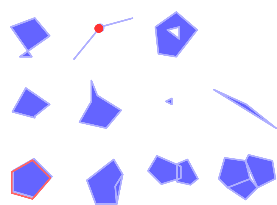
ジオメトリチェッカープラグイン では以下のエラーを探せます:
- Self intersections: a polygon with a self intersection,
- Duplicate nodes: two duplicates nodes in a segment
- Holes: hole in a polygon,
- Segment length: a segment length lower than a threshold,
- Minimum angle: two segments with an angle lower than a threshold,
- Minimum area: polygon area lower than a treshold,
- Silver polygon: this error come from very small polygon (with small area) with a large perimeter,
- Duplicates features,
- Feature within feature,
- Overlaps: polygon overlapping,
- Gaps: gaps between polygons
次の図は、プラグインによって作られた別のチェックを示しています。

The Differents checks supported by the plugin
You can select a row to see the localisation of the error. You can change this
behaviour by selecting another action between error (default),
Feature, Don’t move, and  Highlight contour
of selected features.
Below the zoom action when clicking on the table row, you can Show the selected features in attribute table, Fix selected errors using default resolution and Fix selected errors, prompt for resolution method. In the latter, you will see a window to choose the resolution’s method among which:
- Merge with neighboring polygon with longest shared edge,
- Merge with neighboring polygon with largest area,
- Merge with neighboring polygon identical attribute value,if any, or leave as it
- Delete feature
- No action
ちなみに
複数のエラーを修正する
CTRL+クリック 操作によってテーブルで複数の行を選択することで、複数のエラーを修正できます。
The default action could be changed with the last icon Error resolution settings. For some type of errors, you can change the default action between some specific action or No action.
最後に、 属性[値]で地物をマージするのに使用する属性 がどれか選択できます